Items Similar to Antique Map of Epirus 'Albania, Greece' by J. Janssonius, circa 1650


Want more images or videos?
Request additional images or videos from the seller
1 of 9
Antique Map of Epirus 'Albania, Greece' by J. Janssonius, circa 1650
About the Item
This map covers the northwestern coast of Greece and part of present-day Albania. The map was drawn by Johannes Wilhelm Laurenberg, a mathematician and historian who produced several atlases of Greece and worked with both Blaeu and Hondius/Jansson. The large title cartouche features a shepherd and shepherdess with their livestock.
- Dimensions:Height: 20.79 in (52.8 cm)Width: 25.04 in (63.6 cm)Depth: 0.02 in (0.5 mm)
- Materials and Techniques:
- Period:Mid-17th Century
- Date of Manufacture:circa 1650
- Condition:Minor fading. Some minor staining and folding. Please study image carefully.
- Seller Location:Langweer, NL
- Reference Number:Seller: BG-092011stDibs: LU305439945051
About the Seller
5.0
Platinum Seller
These expertly vetted sellers are 1stDibs' most experienced sellers and are rated highest by our customers.
Established in 2009
1stDibs seller since 2017
1,948 sales on 1stDibs
Typical response time: <1 hour
- ShippingRetrieving quote...Ships From: Langweer, Netherlands
- Return PolicyA return for this item may be initiated within 14 days of delivery.
Auctions on 1stDibs
Our timed auctions are an opportunity to bid on extraordinary design. We do not charge a Buyer's Premium and shipping is facilitated by 1stDibs and/or the seller. Plus, all auction purchases are covered by our comprehensive Buyer Protection. Learn More
More From This SellerView All
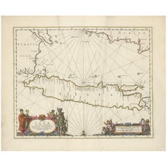
- Antique Map of Java by Janssonius, circa 1650Located in Langweer, NLAntique map titled 'Insulae Iavae cum parte insularum Borneo Sumatrae, et circumjacentium insularum novissima delineatio'. Beautiful map of Java and parts of Bali, Borneo, Sumatra an...Category
Antique Mid-17th Century Maps
MaterialsPaper
- Antique Map of France by Janssonius, c.1650Located in Langweer, NLAntique map titled 'Gallia Vetus'. Beautiful map of France based on Caesar's De Bello Gallico. In the columns to the left and right important tribes and people are described. Art...Category
Antique 17th Century Maps
MaterialsPaper
- Antique Map of the Vermandois Region by Janssonius, circa 1650By Johannes JanssoniusLocated in Langweer, NLAntique map titled 'Vermandois'. Old map of the Vermandois region, France. Vermandois was a French County that appeared in the Merovingian period. Its na...Category
Antique Mid-17th Century Maps
MaterialsPaper
- Antique Map of the Region of Touraine by Janssonius 'circa 1650'By Johannes JanssoniusLocated in Langweer, NLAntique map of France titled 'Touraine - Turonensis Ducatus'. Decorative map of the Touraine region, France. It shows the cities of Tours, Amboise and others. Published by J. Jansson...Category
Antique Mid-17th Century Maps
MaterialsPaper
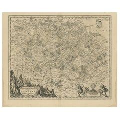
- Antique Map of the Region of Maine by Janssonius, circa 1650By Johannes JanssoniusLocated in Langweer, NLAntique map of France titled 'Diocese du Mans vulgo le Mains'. Decorative map of the region of Maine, France. Published by J. Janssonius.Category
Antique Mid-17th Century Maps
MaterialsPaper
- Antique Map of the Region of Franche-Comté by Janssonius, circa 1650Located in Langweer, NLAntique map titled 'Burgundiae Comitatus Franche Comté'. Old map of the historical and former region of Franche-Comté, France. As a region, it encompasse...Category
Antique Mid-17th Century Maps
MaterialsPaper


You May Also Like
- 17th Century Hand-Colored Map of a Region in West Germany by JanssoniusBy Johannes JanssoniusLocated in Alamo, CAThis attractive highly detailed 17th century original hand-colored map is entitled "Archiepiscopatus Maghdeburgensis et Anhaltinus Ducatus cum terris adjacentibus". It was published ...Category
Antique Mid-17th Century Dutch Maps
MaterialsPaper
- Prussia, Poland, N. Germany, Etc: A Hand-colored 17th Century Map by JanssoniusBy Johannes JanssoniusLocated in Alamo, CAThis is an attractive hand-colored copperplate engraved 17th century map of Prussia entitled "Prussia Accurate Descripta a Gasparo Henneberg Erlichensi", published in Amsterdam by Joannes Janssonius in 1664. This very detailed map from the golden age of Dutch cartography includes present-day Poland, Latvia, Lithuania, Estonia and portions of Germany. This highly detailed map is embellished by three ornate pink, red, mint green and gold...Category
Antique Mid-17th Century Dutch Maps
MaterialsPaper
- Antique Map of Italy by Andriveau-Goujon, 1843By Andriveau-GoujonLocated in New York, NYAntique Map of Italy by Andriveau-Goujon, 1843. Map of Italy in two parts by Andriveau-Goujon for the Library of Prince Carini at Palazzo Carini i...Category
Antique 1840s French Maps
MaterialsLinen, Paper
- Antique Map of Principality of MonacoBy Antonio Vallardi EditoreLocated in Alessandria, PiemonteST/619 - "Old Geographical Atlas of Italy - Topographic map of ex-Principality of Monaco" - ediz Vallardi - Milano - A somewhat special edition ---Category
Antique Late 19th Century Italian Other Prints
MaterialsPaper
- Greece, "Graeciae Antiquae"" A 17th Century Hand-colored Map by SansonBy Nicolas SansonLocated in Alamo, CAThis is an original 17th century hand colored copperplate engraved map of Greece entitled "Graeciae Antiquae Tabula Hanc Geographicam" by Nicolas d'Abbeville Sanson, engraved and pub...Category
Antique Mid-17th Century French Maps
MaterialsPaper
- Southern Greece: A Large 17th C. Hand-colored Map by Sanson and JaillotBy Nicolas SansonLocated in Alamo, CAThis large original hand-colored copperplate engraved map of southern Greece and the Pelopponese Peninsula entitled "La Moree Et Les Isles De Zante, Cefalonie, Ste. Marie, Cerigo & C...Category
Antique 1690s French Maps
MaterialsPaper


Recently Viewed
View AllMore Ways To Browse
The Shepherdess
Shepherd And Shepherdess
Albanian Antique
Albania Antique Map
Albania Map
Antique Fireplaces And Ranges
Antique Florida Collectibles
Antique Victoria Australia
Map Berlin
Antique Sailing Maps
Berlin Maps
Antique Sailing Map
West Coat Of Arms
World Map Copper
Bay Area Antique Furniture
Antique Map Of Portugal
Antique Map Portugal
Antique Map Egypt