
World Map Copper

2
134
5
to
11
113
25
139
139
139
7
6
3
1
1
1
1
1
94
19
21
5
1
7
6
1
4
3
4
1
116
27
16
16
8
55
24
11
9
8
6
4
4
2
2
Sort By
Colored wall map of the WORLD
By Chambon
Located in ZWIJNDRECHT, NL
huge wall map of the world in two hemispheres printed on two sheets, depicting the Eastern and Western
Category

Antique Mid-18th Century French French Provincial Maps

Materials

Wood, Paper

Colored wall map of the WORLD
Free Shipping
H 45 in W 57 in D 0.8 in
Decorative Ancient World Map with Large Parts of the World Still Unknown, c 1731
Located in Langweer, NL
Interesting ancient map of the world, based upon Strabo. The Southern tip of Africa is undiscovered
Category

Antique 1730s Maps

Materials

Paper

Original Antique Map of The World by Thomas Clerk, 1817
Located in St Annes, Lancashire
Great map of The Eastern and Western Hemispheres On 2 sheets Copper-plate engraving Drawn
Category

Antique 1810s English Maps

Materials

Paper

Original Antique Map of The World by Thomas Clerk, 1817
No Reserve
H 10.25 in W 8.25 in D 0.07 in
Antique Copper Engraved Map of Gloucestershire in England, 1637
Located in Langweer, NL
Antique map titled 'Glocestriae comitatus olim sedes Dobunorum'. Map of Gloucestershire, England
Category

Antique 17th Century Maps

Materials

Paper

Detailed Copper Engraved City Map of Enkuizen, the Netherlands, c.1620
By L. Guicciardini
Located in Langweer, NL
Antique map titled 'Die stadt Enchuijsen.' Detailed copper engraved city map of Enkuizen, the
Category

Antique 17th Century Maps

Materials

Paper

Antique Copper Engraved Map of Germany in the Early 18th Century, c.1740
Located in Langweer, NL
original antique maps to collectors, historians, educators and interior decorators all over the world. Our
Category

Antique 18th Century Maps

Materials

Paper

Antique Map of New Jersey
Located in Langweer, NL
Antique map titled 'Colton's New Jersey'. This rare hand colored map of New Jersey is a copper
Category

Antique Mid-19th Century Maps

Materials

Paper

Antique Map of New Jersey
H 17.52 in W 13.59 in D 0.02 in
German Antique Map of Southeastern Australia, 1904
Located in Langweer, NL
chromolithography, rather than copper plate engraving, but reproducing the maps from zinc plates that were etched in
Category

20th Century Maps

Materials

Paper

Antique Map of the Netherlands by Guicciardini, 1582
Located in Langweer, NL
Antique map titled 'Hollandiae Cattorum Regionis Typus'. Early copper engraving of the Netherlands
Category

Antique 16th Century Maps

Materials

Paper

Antique Map of Central Asia and India, 1904
Located in Langweer, NL
antique maps to collectors, historians, educators and interior decorators all over the world. Our
Category

20th Century Maps

Materials

Paper

Antique Map of Central Asia and India, 1904
H 22.09 in W 17.45 in D 0.01 in
Antique Map of New Zealand and Tasmania, 1904
Located in Langweer, NL
chromolithography, rather than copper plate engraving, but reproducing the maps from zinc plates that were etched in
Category

20th Century Maps

Materials

Paper

Antique Map of France with Decorative Border, 1766
Located in Langweer, NL
over the world. Our collection includes a wide range of authentic antique maps from the 16th to the
Category

Antique 18th Century Maps

Materials

Paper

Antique Map of Southern India by Andree, 1904
Located in Langweer, NL
"Antique map titled 'Vorderindien, sudlicher Teil'. Map of India, southern part. This map
Category

20th Century Maps

Materials

Paper

Antique Map of the Low Countries by Brué, 1822
Located in Langweer, NL
over the world. Our collection includes a wide range of authentic antique maps from the 16th to the
Category

Antique 19th Century Maps

Materials

Paper

Antique Map of Celebes 'Sulawesi', Island in Indonesia, 1754
By Jacques-Nicolas Bellin
Located in Langweer, NL
Antique map titled 'Carte De L'Isle Celebes ou Macassar'. Detailed copper engraved map of Celebes
Category

Antique 18th Century Maps

Materials

Paper

Road Map, John Ogilby, No 54, London, Yarmouth, Britannia
By John Ogilby
Located in BUNGAY, SUFFOLK
-sixth year, as a publisher of maps and geographical accounts. Ogilby was born outside Dundee, in
Category

Antique 1670s English Baroque Maps

Materials

Paper

Antique Map of Westfriesland in Ancient Times by Alting, 1697
Located in Langweer, NL
Westfriesland in ancient times. This copper engraved map shows part of Holland as it was in ancient times. It
Category

Antique 17th Century Maps

Materials

Paper

Antique Map of Vlaams-Brabant by Homann Heirs, c.1720
By Homann Heirs
Located in Langweer, NL
Antique map titled 'Ducatus Brabantiae Nova Tabula in qua (..).' Fully engraved copper plate map
Category

Antique 18th Century Maps

Materials

Paper

Antique Map of Celebes 'Sulawesi', Island in Indonesia, c.1750
By Jacques-Nicolas Bellin
Located in Langweer, NL
Antique map titled 'Carte De L'Isle Celebes ou Macassar'. Detailed copper engraved map of Celebes
Category

Antique 18th Century Maps

Materials

Paper

Antique Map of Drenthe, a Province in The Netherlands, 1658
Located in Langweer, NL
Antique map titled 'Drentia comitatus (..)'. Copper engraved contemp. hand coloured map of Drenthe
Category

Antique 17th Century Maps

Materials

Paper

Antique Map of Burma and the Malayan Peninsula by Andree, 1904
Located in Langweer, NL
, rather than copper plate engraving, but reproducing the maps from zinc plates that were etched in relief
Category

20th Century Maps

Materials

Paper

Antique Map of the City of Hindeloopen by Braun & Hogenberg, c.1598
Located in Langweer, NL
world. Our collection includes a wide range of authentic antique maps from the 16th to the 20th
Category

Antique 16th Century Maps

Materials

Paper

Antique Map of Cayenne and Cassepouri, French Guinea, South America, c.1730
Located in Langweer, NL
Antique map titled 'A Map of the Island Cayenne (..)’. A set of interesting copper engravings of
Category

Antique 18th Century Maps

Materials

Paper

Cartographic Elegance: The Art and Science of 17th-Century Asian Maps, ca.1681
Located in Langweer, NL
the map onto a copper plate, which is then used to print the image onto paper. The addition of color
Category

Antique 1680s Maps

Materials

Paper

Captain Cook's Exploration of Tahiti 18th C. Hand-Colored Map by Bellin
By Jacques-Nicolas Bellin
Located in Alamo, CA
This beautiful 18th century hand-colored copper plate engraved map is entitled "Carte de l'Isle de
Category

Antique Mid-18th Century French Maps

Materials

Paper

Map Road Strip Britannia Sheet 2 John Ogilby London Aberistwith Islip Bramyard
By John Ogilby
Located in BUNGAY, SUFFOLK
of England and Wales. Strip map Islip to Bramyard, on a scale of approximately one inch to the mile
Category

Antique 17th Century English Baroque Maps

Materials

Paper

Map Road John Ogilby Britannia No 74 Ipswich to Norwich Cromer Framed
By John Ogilby
Located in BUNGAY, SUFFOLK
his sixty-sixth year, as a publisher of maps and geographical accounts. Ogilby was born outside
Category

Antique 1670s English Baroque Maps

Materials

Paper

Road Map John Ogilby No 75 Kings Lyn Harwich, Britannia Framed Wallhanging
By John Ogilby
Located in BUNGAY, SUFFOLK
, as a publisher of maps and geographical accounts. Ogilby was born outside Dundee, in 1600, the
Category

Antique 1670s European Baroque Maps

Materials

Paper

Antique Map of the City of Bolsward, Friesland in The Netherlands, c.1598
Located in Langweer, NL
Cologne/Germany. He was a prolific copper engraver and etching artist of maps and town views. In
Category

Antique 16th Century Maps

Materials

Paper

Antique Map of Great Britain and Ireland by Brion de la Tour, 1766
Located in Langweer, NL
the world. Our collection includes a wide range of authentic antique maps from the 16th to the 20th
Category

Antique 18th Century Maps

Materials

Paper

Antique Map of 'African' Islands in the Mediterranean Sea and The Atlantic, 1747
Located in Langweer, NL
and the Dutch fortress. Repair in the map of the Cap Verde Islands. The images on the copper plate
Category

Antique 18th Century Maps

Materials

Paper

Early Map of Puerto Rico Printed in Venice by G. F. Camocio in 1571
Located in Langweer, NL
World), this map made its debut in the 16th century and remained a significant inclusion in several
Category

Antique 16th Century Maps

Materials

Paper

Road Map No43 London to Kings Lynn, Royston to Downham, John Ogilby, Britannia
By John Ogilby
Located in BUNGAY, SUFFOLK
John Ogilby (British 1600-1676) Cosmographer and Geographick Printer to Charles II. A road map
Category

Antique Late 17th Century British Charles II Maps

Materials

Paper

Road Map John Ogilby London St David's Britannia No 15 Abingdon Monmouth Framed
By John Ogilby
Located in BUNGAY, SUFFOLK
John Ogilby (British 1600-1676) Cosmographer and Geographick Printer to Charles II. A road map from
Category

Antique 1670s English Baroque Maps

Materials

Paper

Handsome Old Detailed Map of the Low Countries by Famous Mapmaker Blaeu, ca.1635
Located in Langweer, NL
sought after- detailed map of the Low Countries by the world most famous map maker Blaeu. With beautiful
Category

Antique 1630s Maps

Materials

Paper

Road Map Britannia No 32 the Road from London to Barnstable John Ogilby Framed
By John Ogilby
Located in BUNGAY, SUFFOLK
A road map from Britannia, by John Ogilby Esq., Cosmographer and Geographick Printer to Charles II
Category

Antique Late 17th Century English Charles II Maps

Materials

Paper

Road Map Britannia No 15 London to St Davids John Ogilby Brown Gilt Frame
By John Ogilby
Located in BUNGAY, SUFFOLK
Lechlade, to Fairford, to Barnsley to Gloucester showing Monmouth as the destination. A road map from
Category

Antique Late 17th Century British Charles II Maps

Materials

Paper

City View of Nuremberg, Germany: An 18th Century Hand-Colored Map by M. Seutter
By Matthew Seutter
Located in Alamo, CA
prominent area of German text occupies the lower right corner. This large colorful copper-plate hand
Category

Antique Mid-18th Century German Maps

Materials

Paper

Road Map Britannia No 25 London to the Lands End, John Ogilby Brown Gilded Frame
By John Ogilby
Located in BUNGAY, SUFFOLK
Senan in Cornwall. By John Ogilby His Majesties Cosmographer. A road map from Britannia, 1675/6. No 25
Category

Antique Late 17th Century British Charles II Maps

Materials

Paper

Road Map Britannia 1675/6 No 5 Road London to Barwick, London Stilton Grey Frame
By John Ogilby
Located in BUNGAY, SUFFOLK
John Ogilby (British 1600-1676) cosmographer and geographick printer to Charles II. A road map from
Category

Antique Late 17th Century British Charles II Maps

Materials

Paper

Comore Island Original Antique Engraving by Van Schley, 1749
Located in Langweer, NL
Antique map titled 'Carte des Isles de Comore Johanna ou Anouan Mohilla ou Moaly et Mayote
Category

Antique 18th Century Maps

Materials

Paper

Comore Island Original Antique Engraving by Van Schley, 1749
Free Shipping
H 10.24 in W 11.3 in D 0 in
Duchy of Brunswick-Lüneburg, 1595: A Renaissance Cartographic Masterpiece
Located in Langweer, NL
exquisite example of Abraham Ortelius’s cartographic craftsmanship: an original antique copper engraving
Category

Antique 16th Century Maps

Materials

Paper

Large Sea Chart of the Zuyder Zee & The Northsea with the Wadden Islands, 1773
By H. van Loon
Located in Langweer, NL
The copper engraving by Herman van Loon, published by Pieter Mortier in 'Le Neptune François' in
Category

Antique Late 18th Century Maps

Materials

Paper

1800s French Map of the World in Two Hemispheres - Le Dictionnaire Géographique
Located in Montréal, CA
of Publication: Paris Date: 1819 Paper Dimensions: 8 x 14 7/8 inches. Medium: Copper engraving
Category

Antique Early 19th Century French Prints

Materials

Paper

Original Vintage World War Two French Wine Vineyard Copper Recycling WWII Design
By Rene Ravo
Located in London, GB
Original vintage World War Two era propaganda poster - French vineyards are in peril To sulfate our
Category

Vintage 1940s French Posters

Materials

Paper

Jacques Nicolas Bellin, St Lucia, West Indies, Hand Colored Map
By Jacques-Nicolas Bellin
Located in Norwich, GB
Carte De L’Isle De Sainte Lucie Detailed copper engraved map of Saint Lucia by Jacques Nicolas
Category

Antique 1770s Dutch Georgian Prints

Materials

Paper

Rare Copper Engraving of Female with Five Breasts Lactating onto Others, 1686
Located in Langweer, NL
folio world atlas, the first in over 60 years to publish a new set of folio county maps, the first to
Category

Antique 1680s Religious Items

Materials

Paper

Earthly Treasures No 23 a Horse Chestnut & Mineral Sculpture by Morrison Thomas
By Morrison Thomas
Located in London, GB
made from burred Horse Chestnut inlaid with Native Copper, Malachite & Chrysocolla. Morrison turns
Category

2010s British Organic Modern Abstract Sculptures

Materials

Malachite, Copper

Earthly Treasures No 25, an Acacia & Mixed Mineral Sculpture by Morrison Thomas
By Morrison Thomas
Located in London, GB
made from burred Acacia inlaid with Native Copper, Malachite, Gold, Chrysocolla & Turquoise
Category

2010s British Organic Modern Natural Specimens

Materials

Malachite, Copper, Gold Leaf

Antique Print of Deer Hunting, circa 1680
Located in Langweer, NL
Copper engraving depicting a stag hunt. It shows deer hunting. Source unknown, to be determined
Category

Antique 17th Century Prints

Materials

Paper

Antique Print of a Shipwreck Near Arrakan in India, 1775
Located in Langweer, NL
Antique print titled 'Schipbreuk van 't Jagt Coromandel'. Copper engraving of a VOC shipwreck near
Category

Antique 18th Century Prints

Materials

Paper

Antique Print of a Winter House in Greenland, 1768
By Prevost
Located in Langweer, NL
Antique print titled 'Coupe sur la longueur d'une Maison d'Hiver (..)'. Copper engraving of a house
Category

Antique 18th Century Prints

Materials

Paper

Antique Print of Castle Batestein in Vianen, the Netherlands, 1749
Located in Langweer, NL
the world. Our collection includes a wide range of authentic antique maps from the 16th to the 20th
Category

Antique 18th Century Prints

Materials

Paper

Antique Print of a Cave near the Yenisei River in Siberia, Russia, 1768
Located in Langweer, NL
Antique print titled 'Grotte remplie d'Idoles'. Copper engraving of the cave filled with idols on
Category

Antique 18th Century Prints

Materials

Paper

Antique Print of Castle Batestein in Vianen, the Netherlands
Located in Langweer, NL
world. Our collection includes a wide range of authentic antique maps from the 16th to the 20th
Category

Antique 18th Century Prints

Materials

Paper

Antique Print of a Chinese Temple and Chinese deity Calamija by Valentijn, 1726
Located in Langweer, NL
the world. Our collection includes a wide range of authentic antique maps from the 16th to the 20th
Category

Antique 18th Century Prints

Materials

Paper

Antique Print of a Chinese Temple and Chinese deity Calamija by Valentijn, 1726
Located in Langweer, NL
interior decorators all over the world. Our collection includes a wide range of authentic antique maps from
Category

Antique 18th Century Prints

Materials

Paper

Antique Print of a Yurt and Natives of Kamchatka, Russia, 1770
By Prevost
Located in Langweer, NL
Antique print titled 'Iourte ou Habitation Souterraine (..)'. Copper engraving of a yurt and
Category

Antique 18th Century Prints

Materials

Paper

Antique Print of Darts for Fishing and Kayak, 1768
Located in Langweer, NL
Antique print titled 'Dards pour la Pêche (..)'. Copper engraving of darts for fishing and a kayak
Category

Antique 18th Century Prints

Materials

Paper

Antique Engraving of Animals of Siberia, 1768
Located in Langweer, NL
interior decorators all over the world. Our collection includes a wide range of authentic antique maps from
Category

Antique 18th Century Prints

Materials

Paper

  • 1
Get Updated with New Arrivals
Save "World Map Copper", and we’ll notify you when there are new listings in this category.

World Map Copper For Sale on 1stDibs

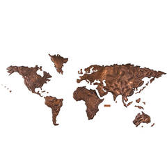
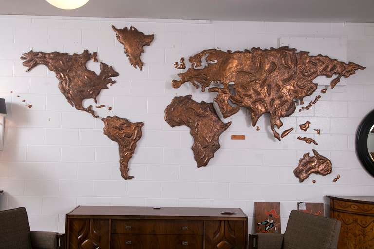
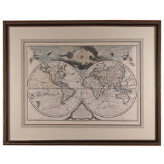
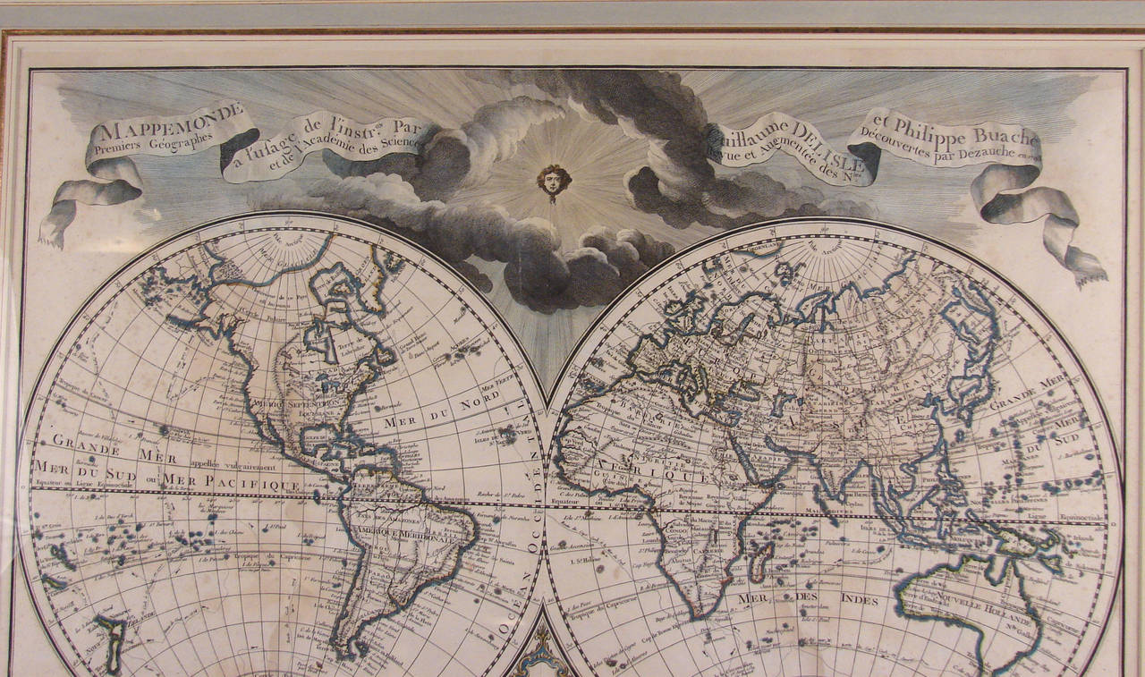
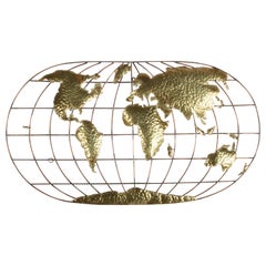
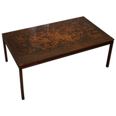
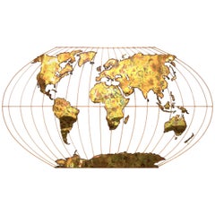
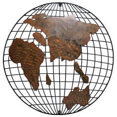
Find many varieties of an authentic world map copper available at 1stDibs. Each world map copper for sale was constructed with extraordinary care, often using paper, metal and 
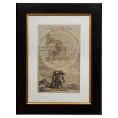
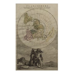
wood. If you’re shopping for a world map copper, we have 65 options in-stock, while there are 4 modern editions to choose from as well. There are many kinds of the world map copper you’re looking for, from those produced as long ago as the 18th Century to those made as recently as the 21st Century. Each world map copper bearing Baroque or Georgian hallmarks is very popular. Jacques-Nicolas Bellin, Morrison Thomas and Prevost each produced at least one beautiful world map copper that is worth considering.

How Much is a World Map Copper?

A world map copper can differ in price owing to various characteristics — the average selling price 1stDibs is $439, while the lowest priced sells for $79 and the highest can go for as much as $238,935.