Items Similar to Jacques Nicolas Bellin, St Lucia, West Indies, Hand Colored Map


Want more images or videos?
Request additional images or videos from the seller
1 of 5
Jacques Nicolas Bellin, St Lucia, West Indies, Hand Colored Map
About the Item
Carte De L’Isle De Sainte Lucie
Detailed copper engraved map of Saint Lucia by Jacques Nicolas Bellin.
This map was completed by Krevely 1775 for for the rare Dutch edition of "Histoire Generale Des Voyages”.
Copper engraving, 20.5 x 30 cm, original hand-colour, blank verso.
Bellin (1703 - 1772), a French mapmaker, was named the hydrographer (chief cartographer) to the French Navy, and later, the Official Hydrographer to the French King. During his term as Official Hydrographer, the Depot was the single most active center for the production of sea charts and maps, including a large folio format sea-chart of France, the Neptune Francois. He also produced a number of sea-atlases of the world, e.g., the Atlas Maritime and the Hydrographie Francaise. These gained fame, distinction, and respect all over Europe and were republished throughout the 18th and even in the succeeding century.
- Creator:Jacques-Nicolas Bellin (Artist)
- Dimensions:Height: 8.08 in (20.5 cm)Width: 11.82 in (30 cm)Depth: 0.04 in (1 mm)
- Style:Georgian (Of the Period)
- Materials and Techniques:
- Place of Origin:
- Period:1770-1779
- Date of Manufacture:1775
- Condition:Wear consistent with age and use.
- Seller Location:Norwich, GB
- Reference Number:1stDibs: LU7031229958032

Jacques-Nicolas Bellin
Jacques Nicolas Bellin (1703 –1772) was a French hydrographer (official cartographer) and a geographer. While still a teenager he became the chief cartographer to the French Navy and later to the king of France. Bellin created a large number of maps for Antoine François Prévost's (L'Abbe Prevost) 'Histoire Generale des Voyages', which was a 25 volume publication focused on 17th and 18th century exploration.It was published in French, Dutch and German. He also contributed maps and articles to the 35-volume Encyclopédie edited by Denis Diderot and Jean le Rond d'Alembert. He was part of the group called Philosophes, which included many of the great intellectuals of the Age of Enlightenment, including Voltaire, Rousseau and Montesquieu. Bellin died at Versailles in 1772.
About the Seller
No Reviews Yet
Vetted Seller
These experienced sellers undergo a comprehensive evaluation by our team of in-house experts.
Established in 1992
1stDibs seller since 2022
9 sales on 1stDibs
- ShippingRetrieving quote...Ships From: Norwich, United Kingdom
- Return PolicyA return for this item may be initiated within 14 days of delivery.
More From This SellerView All
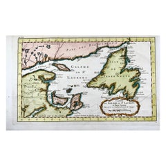
- Bellin, Canada, Gulf of Saint Lawrence, Hand Coloured EngravingBy Jacques-Nicolas BellinLocated in Norwich, GBJ.V. Schley after Bellin ‘Carte du Golphe de St. Laurent et Pays Voisins’ Size: 14.2 x 8.6 inches 36.1 x 21.8 cm First state of this nice copper engraved map of St. Lawrence Bay with Anticosti Island, Prince Edward Island, Cape Breton...Category
Antique 1780s French Prints
MaterialsPaper
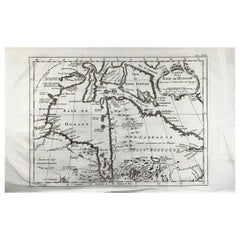
- Bellin, map, Hudson Bay, Canada, James Bay, LabradorLocated in Norwich, GB“Carte de la Baye de Hudson” Map of the Hudson Bay area of Northern Canada. Shows Hudson Bay, James Bay, Labrador (previously called New Brittany by the Fr...Category
Antique 1880s American Prints
MaterialsPaper
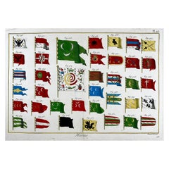
- Marine Pavillons, Flags, Folio in Original Hand ColorBy Jacques-Nicolas BellinLocated in Norwich, GBTableau des Pavillons Que la Plupart des Nations Arborent a La Mer- Marine Flags After Jacques-Nicolas Bellin. Copperplate engraving and et...Category
Antique 1780s French Georgian Prints
MaterialsPaper
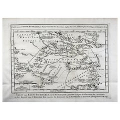
- Schley, Xinjiang Uygur Zizhiqu, Tien Shan, Sinkiang, Map of ChinaBy Jacques-Nicolas BellinLocated in Norwich, GBJ.V. Schley Carte de la petite Bukharie et pays voisins ; Kaart van Klyn-Bukharia, en de nabuurige landen Xinjiang Uygur Zizhiqu (China), Tien Shan, Sinkiang. Relief shown pict...Category
Antique 1740s Dutch Prints
MaterialsPaper
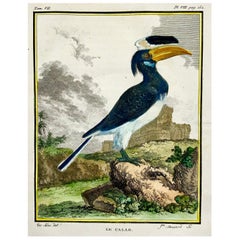
- Calao, Hornbill, Fine Quarto Hand Colored Copper EngravingBy Jacques Eustache de SeveLocated in Norwich, GBEngraving on hand laid (verge) paper. Issued for the famed First Edition in quarto of the “Histoire naturelle des oiseaux.”, by Georges-Louis Leclerc, Comte de Buffon, ed. published in Paris ca 1775. Made by ‘Mansard’ after ‘Jacques de Seve...Category
Antique 1770s French Georgian Prints
MaterialsPaper
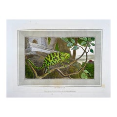
- 1807 William Daniell, Chameleon, Reptile, Hand Colored AquatintBy William DaniellLocated in Norwich, GBDesigned and engraved by William Daniell for his work “Interesting Selections from Animated Nature.” Published by Cadell & Davies, London. Aquatint...Category
Antique Early 1800s English Georgian Prints
MaterialsPaper
You May Also Like
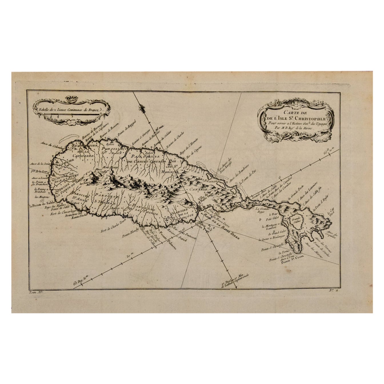
- St. Christophe 'St. Kitts' Island: An 18th Century Hand-colored Map by BellinBy Jacques-Nicolas BellinLocated in Alamo, CAJacques Bellin's copper-plate map of the Caribbean island of Saint Kitts entitled "Carte De De l'Isle St. Christophe Pour servir á l'Histoire Genle. des V...Category
Antique Mid-18th Century French Maps
MaterialsPaper
- Captain Cook's Exploration of Tahiti 18th C. Hand-Colored Map by BellinBy Jacques-Nicolas BellinLocated in Alamo, CAThis beautiful 18th century hand-colored copper plate engraved map is entitled "Carte de l'Isle de Taiti, par le Lieutenant J. Cook" was created by Jacques Nicolas Bellin and publish...Category
Antique Mid-18th Century French Maps
MaterialsPaper
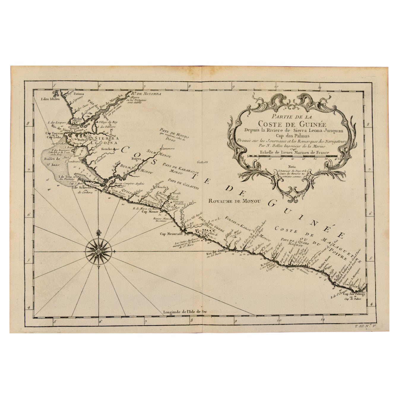
- West Coast of Africa, Guinea & Sierra Leone: An 18th Century Map by BellinBy Jacques-Nicolas BellinLocated in Alamo, CAJacques Bellin's copper-plate map entitled "Partie de la Coste de Guinee Dupuis la Riviere de Sierra Leona Jusquau Cap das Palmas", depicting the coast of Guinea and Sierra Leone in ...Category
Antique Mid-18th Century French Maps
MaterialsPaper
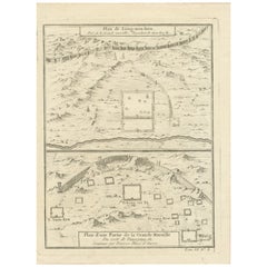
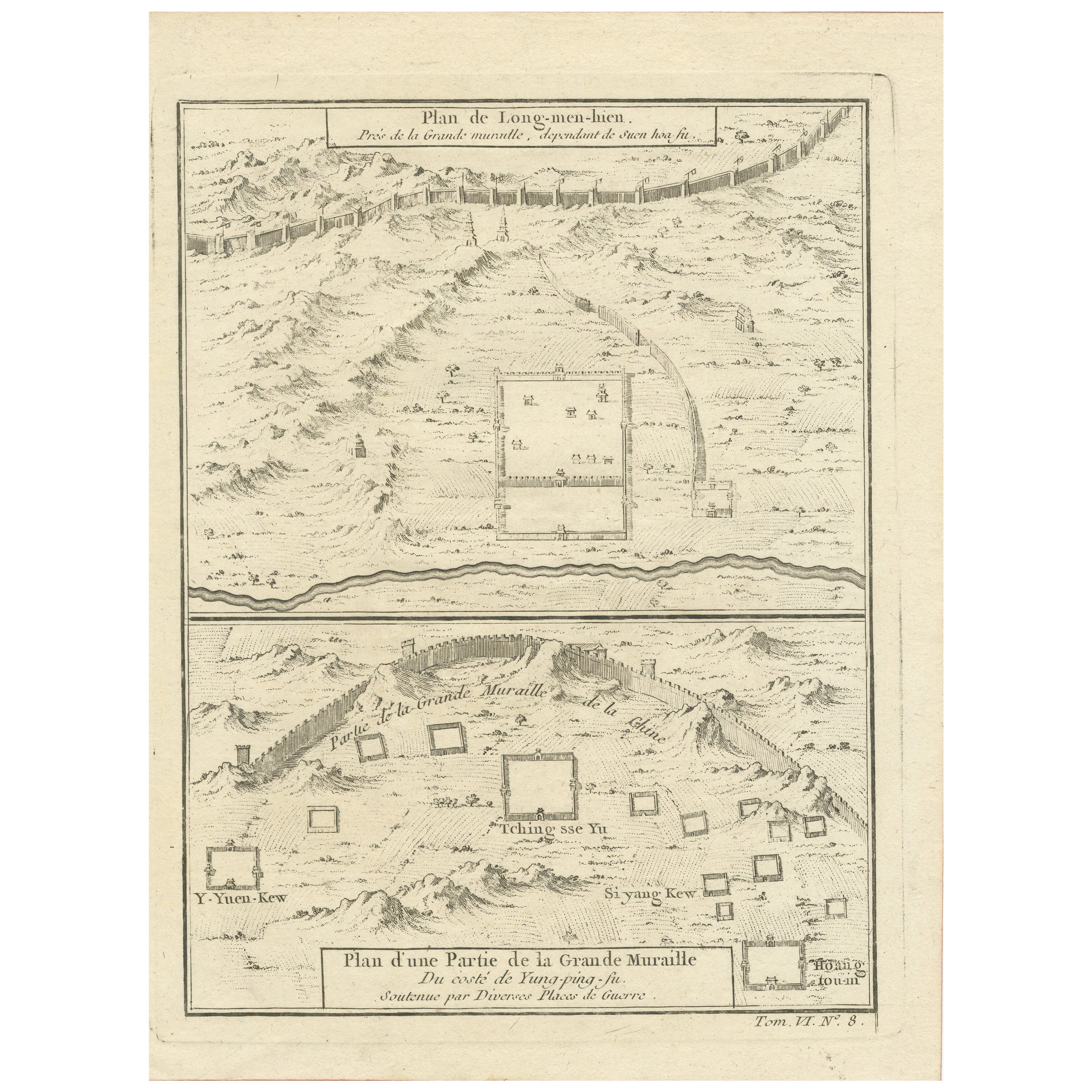
- 1749 Jacques Nicolas Bellin Map of the Great Wall of China Near Kiang-nan fuLocated in Langweer, NLThis original antique image is an historical map by Jacques Nicolas Bellin, depicting the Great Wall of China as it was understood in the mid-18th century. The map includes French ...Category
Antique 1750s Prints
MaterialsPaper
- Antique Map of Celebes 'Sulawesi, Indonesia' by Bellin, ciarca 1755By Jacques-Nicolas BellinLocated in Langweer, NLAntique map titled 'Carte de l'Isle Celebes ou Macassar'. Map of Celebes (Sulawesi, Indonesia), showing Makassar, which was the most important trading city of eastern Indonesia in th...Category
Antique Mid-18th Century European Maps
MaterialsPaper
- Antique Map of Tartary and Northeast Asia by Bellin, circa 1750By Jacques-Nicolas BellinLocated in Langweer, NLAntique map titled 'Carte de la Tartarie Occidentale'. Map of Tartary and northeast Asia, from Lake Baykal, Partie du Siberia in the north, Pays des Kalkas at the center, as well as ...Category
Antique Mid-18th Century European Maps
MaterialsPaper