Items Similar to Bellin, map, Hudson Bay, Canada, James Bay, Labrador


Want more images or videos?
Request additional images or videos from the seller
1 of 7
Bellin, map, Hudson Bay, Canada, James Bay, Labrador
About the Item
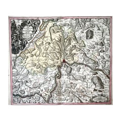
“Carte de la Baye de Hudson”
Map of the Hudson Bay area of Northern Canada. Shows Hudson Bay, James Bay, Labrador (previously called New Brittany by the French).
One area of Quebec labelled ‘Esquimaux’. Parts of present day Manitoba labelled ‘Land entirely Unknown’.
This fine, original copper-plate engraved antique map by Jacques Nicolas Bellin.
24.7 x 37.3 cm
Excellent condition. Old folds flattened.
- Dimensions:Height: 24.8 in (63 cm)Width: 23.8 in (60.46 cm)Depth: 0.1 in (2.54 mm)
- Materials and Techniques:
- Place of Origin:
- Period:
- Date of Manufacture:1880
- Condition:Wear consistent with age and use.
- Seller Location:Norwich, GB
- Reference Number:1stDibs: LU7031230733022
About the Seller
No Reviews Yet
Vetted Seller
These experienced sellers undergo a comprehensive evaluation by our team of in-house experts.
Established in 1992
1stDibs seller since 2022
8 sales on 1stDibs
- ShippingRetrieving quote...Ships From: Norwich, United Kingdom
- Return PolicyA return for this item may be initiated within 14 days of delivery.
More From This SellerView All
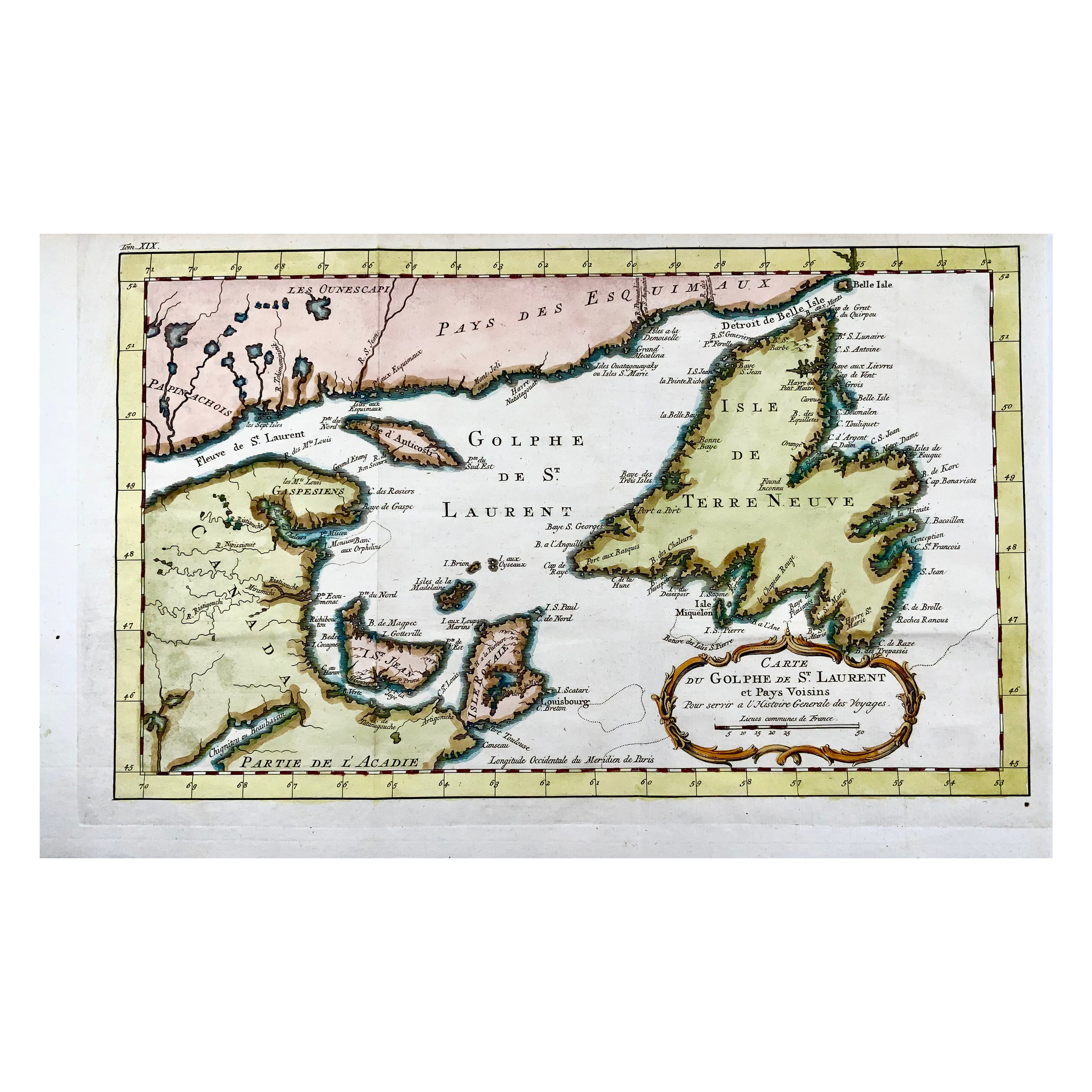
- Bellin, Canada, Gulf of Saint Lawrence, Hand Coloured EngravingBy Jacques-Nicolas BellinLocated in Norwich, GBJ.V. Schley after Bellin ‘Carte du Golphe de St. Laurent et Pays Voisins’ Size: 14.2 x 8.6 inches 36.1 x 21.8 cm First state of this nice copper engraved map of St. Lawrence Bay with Anticosti Island, Prince Edward Island, Cape Breton...Category
Antique 1780s French Prints
MaterialsPaper
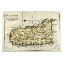
- Jacques Nicolas Bellin, St Lucia, West Indies, Hand Colored MapBy Jacques-Nicolas BellinLocated in Norwich, GBCarte De L’Isle De Sainte Lucie Detailed copper engraved map of Saint Lucia by Jacques Nicolas Bellin. This map was completed by Krevely 1775 for for the rare Dutch edition of ...Category
Antique 1770s Dutch Georgian Prints
MaterialsPaper
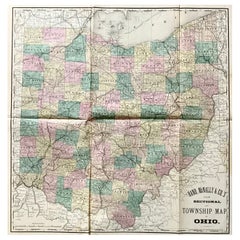
- Hardesty, Sectional & Township Map of Ohio, Very LargeLocated in Norwich, GBRand, McNally & Co.'s New Sectional And Township Map of Ohio 24.8 x 24.3 inches folding into 6 sections. Colour printed in part. Chicago, 1880. Scale: 1:633,600 Fine early large scale map...Category
Antique 1880s American Prints
MaterialsPaper
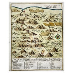
- Map of Indonesia, Semarang, Kartasoera, Soerabaya by SchleyBy Jakob van der SchleyLocated in Norwich, GB'Carte du Chemin entre Samarang et Cartasoera, kaart van den weg tusschen Samarang en Cartasoera' Map of the Road between Semarang and Kartasura by Van Schley. Published 1763. ...Category
Antique 1760s Indonesian Georgian Prints
MaterialsPaper
- 1750 Schaffhausen, Seutter, Large and Detailed Map SwitzerlandBy Matthew SeutterLocated in Norwich, GBSandrart Joachim, von (1606-1688) Effigies antiquae Romae. redacta a Pyrrho Ligorio Romano, per XIIII Regiones, in quas Urbem divisit Imp. Caesar August. Nuremberg, Germany, pu...Category
Antique 1670s Italian Baroque Prints
MaterialsPaper
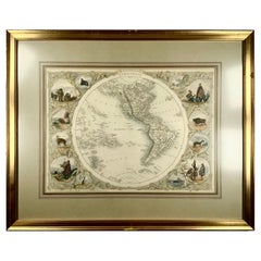
- 1850c J. & F. Tallis, Western Hemisphere Map, Fine Hand Color, FramedBy Philippe TallisLocated in Norwich, GBWestern Hemisphere - America Framed in relatively modern gilt frame and matting. Tallis' decorative maps provided up-to-date geographical knowledge, but also used vignette view...Category
Antique 1850s British High Victorian Prints
MaterialsPaper

You May Also Like
- Antique Map of Siberia by Bellin, 1754Located in Langweer, NLAntique map titled 'Carte de la Siberie'. Detailed map of Siberia, extending from the White Sea and the Caspian Sea in the west to Irkuckoi Province, Jakutky on the Lena River and regions just to the east. Centered on the Jenisi River. Originates from Prévost's 'Histoire Générale des Voyages'. Artists and Engravers: Jacques-Nicolas Bellin (1703-1772) was among the most important mapmakers of the eighteenth century. In 1721, at age 18, he was appointed hydrographer (chief cartographer) to the French Navy. In August 1741, he became the first Ingénieur de la Marine of the Depot des cartes...Category
Antique 18th Century Maps
MaterialsPaper
- Antique Map of Japan by J.N. Bellin, 1752Located in Langweer, NLBellin's wonderfully detailed map of Japan from the atlas of Prevost d'Exiles' influential collection of travel narratives, Histoire Generale des Voyages. Considered the best general...Category
Antique Mid-18th Century Maps
MaterialsPaper
- Antique Map of Eastern Siberia by Bellin '1768'Located in Langweer, NLAntique map titled 'Suite de la Carte de la Siberie et le Pays de Kamtchatka'. Original antique map of the eastern portion of Siberia, centered on eastern Russia and the Mer d'Ochozk (Sea of Okhotsk) showing the Kamchatka Peninsula and I. de Beringe and I. Sagalin. The map shows the tracks of Russian ships...Category
Antique Mid-18th Century Maps
MaterialsPaper
- Antique Map of Boulogne-sur-Mer by Bellin '1764'Located in Langweer, NLAntique map titled 'Plan de la Ville de Boulogne'. Original antique map of Boulogne-sur-Mer, France. This map originates from 'Le petit atlas maritime: recueil de cartes et plans des...Category
Antique Mid-18th Century Maps
MaterialsPaper
- Antique Map of the Arabian Peninsula by Bellin 'c.1740'Located in Langweer, NLAntique map titled 'Carte de la Coste d'Arabie, Mer Rouge et Golfe de Perse'. Original antique map of the Arabian Peninsula, labes both Mecca and Med...Category
Antique Mid-18th Century Maps
MaterialsPaper
- Antique Map of Celebes 'Sulawesi, Indonesia' by Bellin, ciarca 1755By Jacques-Nicolas BellinLocated in Langweer, NLAntique map titled 'Carte de l'Isle Celebes ou Macassar'. Map of Celebes (Sulawesi, Indonesia), showing Makassar, which was the most important trading city of eastern Indonesia in th...Category
Antique Mid-18th Century European Maps
MaterialsPaper


Recently Viewed
View AllMore Ways To Browse
Antique French Canadian Furniture
French Canadian Antique Furniture
Brittany France Antiques
Antique Brittany
Northern France Map
Hudson Bay Furniture
Canada Map
Maps Canada
Map Of Canada
Bay Area Antique Furniture
Antique Maps Canada
Antique Map Canada
Canada Antique Map
Antique Maps Of Canada
Antique Labrador
Labrador Antique
Antique Hudson Bay
Antique Canadian Maps