Items Similar to 1850c J. & F. Tallis, Western Hemisphere Map, Fine Hand Color, Framed


Want more images or videos?
Request additional images or videos from the seller
1 of 9
1850c J. & F. Tallis, Western Hemisphere Map, Fine Hand Color, Framed
About the Item
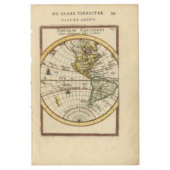
Western Hemisphere - America
Framed in relatively modern gilt frame and matting.
Tallis' decorative maps provided up-to-date geographical knowledge, but also used vignette views within the map's design to show the native people and their occupations, cities and points of interest. The maps hark back to a cartographic tradition from the Dutch mapmakers of the seventeenth century with finely engraved decorative borders. The maps were drawn and engraved by John Rapkin with views drawn and engraved by a number of prominent artists. The maps were issued as a complete volume from 1851 until about 1865.
- Creator:Philippe Tallis (Artist)
- Dimensions:Height: 15.75 in (40 cm)Width: 19.49 in (49.5 cm)Depth: 1.58 in (4 cm)
- Style:High Victorian (Of the Period)
- Materials and Techniques:
- Place of Origin:
- Period:
- Date of Manufacture:1850
- Condition:Wear consistent with age and use. Minor marginal edge wear. Minor wear to frame.
- Seller Location:Norwich, GB
- Reference Number:1stDibs: LU7031229565912
About the Seller
No Reviews Yet
Vetted Seller
These experienced sellers undergo a comprehensive evaluation by our team of in-house experts.
Established in 1992
1stDibs seller since 2022
9 sales on 1stDibs
- ShippingRetrieving quote...Ships From: Norwich, United Kingdom
- Return PolicyA return for this item may be initiated within 14 days of delivery.
More From This SellerView All
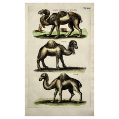
- 1657 Matthaus Merian, Dromedary Camels, Fine Folio in Hand ColorBy Matthäus Merian the ElderLocated in Norwich, GBFine folio engraving in hand color. This rare antique engraving was published in the series: 'Historiae Naturalis' by John Johnston, published and engraved by Matthias Merian in 1657. Matthaus Merian...Category
Antique 1650s German Baroque Prints
MaterialsPaper
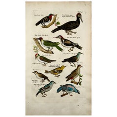
- 1657 Matthaus Merian, Woodpeckers Picus, Birds, Fine Folio in Hand ColorBy Matthäus Merian the ElderLocated in Norwich, GBFine folio engraving in hand color. This rare antique engraving was published in the series: 'Historiae Naturalis De Avibus Libri VI' by John Johnston, published and engraved by Matthias Merian in 1657. Matthaus Merian...Category
Antique 1650s German Baroque Prints
MaterialsPaper
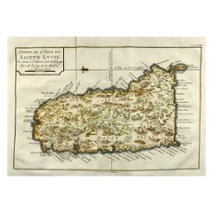
- Jacques Nicolas Bellin, St Lucia, West Indies, Hand Colored MapBy Jacques-Nicolas BellinLocated in Norwich, GBCarte De L’Isle De Sainte Lucie Detailed copper engraved map of Saint Lucia by Jacques Nicolas Bellin. This map was completed by Krevely 1775 for for the rare Dutch edition of ...Category
Antique 1770s Dutch Georgian Prints
MaterialsPaper
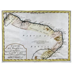
- Krevelt, Map, Coast of Brazil, South America, Amazon, Hand ColouredLocated in Norwich, GBCarte Du Bresil Prem. Partie Depuis la Riviere des Amazones jusqu' à la Baie de Tous les Saints Pour servir à l'Histoire des Etablissemens Europeens. A. v. Krevelt, sculpsit, ...Category
Antique Late 18th Century French Prints
MaterialsPaper
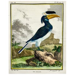
- Calao, Hornbill, Fine Quarto Hand Colored Copper EngravingBy Jacques Eustache de SeveLocated in Norwich, GBEngraving on hand laid (verge) paper. Issued for the famed First Edition in quarto of the “Histoire naturelle des oiseaux.”, by Georges-Louis Leclerc, Comte de Buffon, ed. published in Paris ca 1775. Made by ‘Mansard’ after ‘Jacques de Seve...Category
Antique 1770s French Georgian Prints
MaterialsPaper
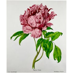
- 1860c Anton Hartinger, Paeonia Rose, Stone Lithograph with Hand Colored, FolioBy Anton HartingerLocated in Norwich, GBLithograph in the Crayon Manier with vibrant hand colour. Published ca 1860. Anton Hartinger was born in Vienna. He was a member of the Academy of Fine Arts Vienna from 1843 to...Category
Antique 1860s Dutch High Victorian Prints
MaterialsPaper
You May Also Like
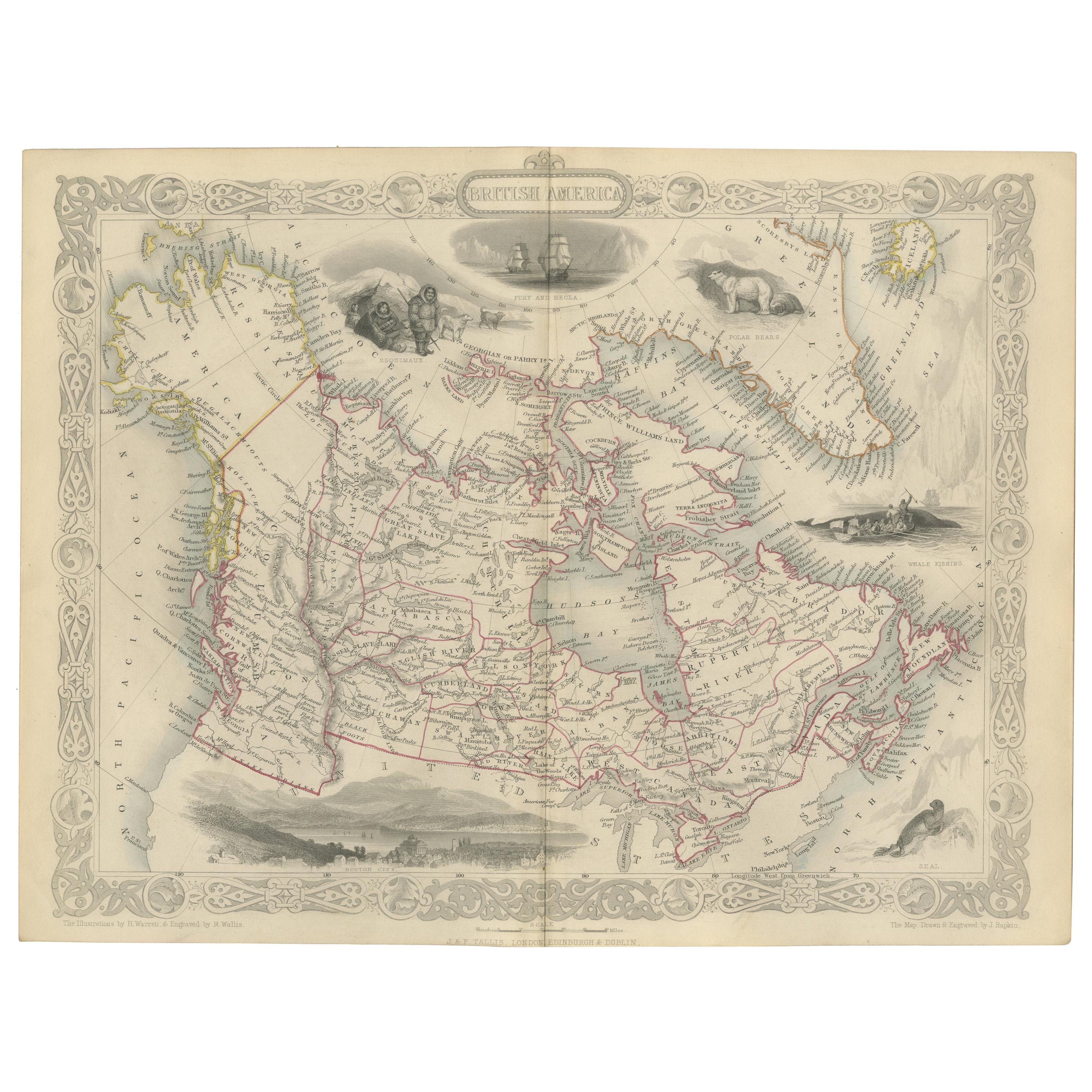
- Antique Map of British America by Tallis 'c.1850'Located in Langweer, NLAntique map titled 'British America'. Decorative map of British America, with vignettes showing Whale Fishing, Montreal, Fury and Hecla ships asail. Thi...Category
Antique Mid-19th Century Maps
MaterialsPaper
- Antique Map of West Canada by Tallis 'c.1850'Located in Langweer, NLAntique map titled 'West Canada'. Original antique map of West Canada, with decorative vignettes titled Kingston and Falls of Niagara. This map originates from 'The History and Topog...Category
Antique Mid-19th Century Maps
MaterialsPaper
- Antique Map of the Western Hemisphere by Wyld '1845'Located in Langweer, NLAntique map titled 'Western Hemisphere'. Original antique map of the western hemisphere. This map originates from 'An Atlas of the World, Comprehending Separate Maps of its...Category
Antique Mid-19th Century Maps
MaterialsPaper
- Original Antique Map of Belgium by Tallis, Circa 1850Located in St Annes, LancashireGreat map of Belgium Steel engraving Many lovely vignettes Published by London Printing & Publishing Co. ( Formerly Tallis ), C.1850 Origin...Category
Antique 1850s English Maps
MaterialsPaper
- Original Antique Map / City Plan of Brussels by Tallis, circa 1850Located in St Annes, LancashireGreat map of Brussels. Steel engraving. Published by London Printing & Publishing Co. (Formerly Tallis), C.1850 Free shipping.Category
Antique 1850s English Maps
MaterialsPaper
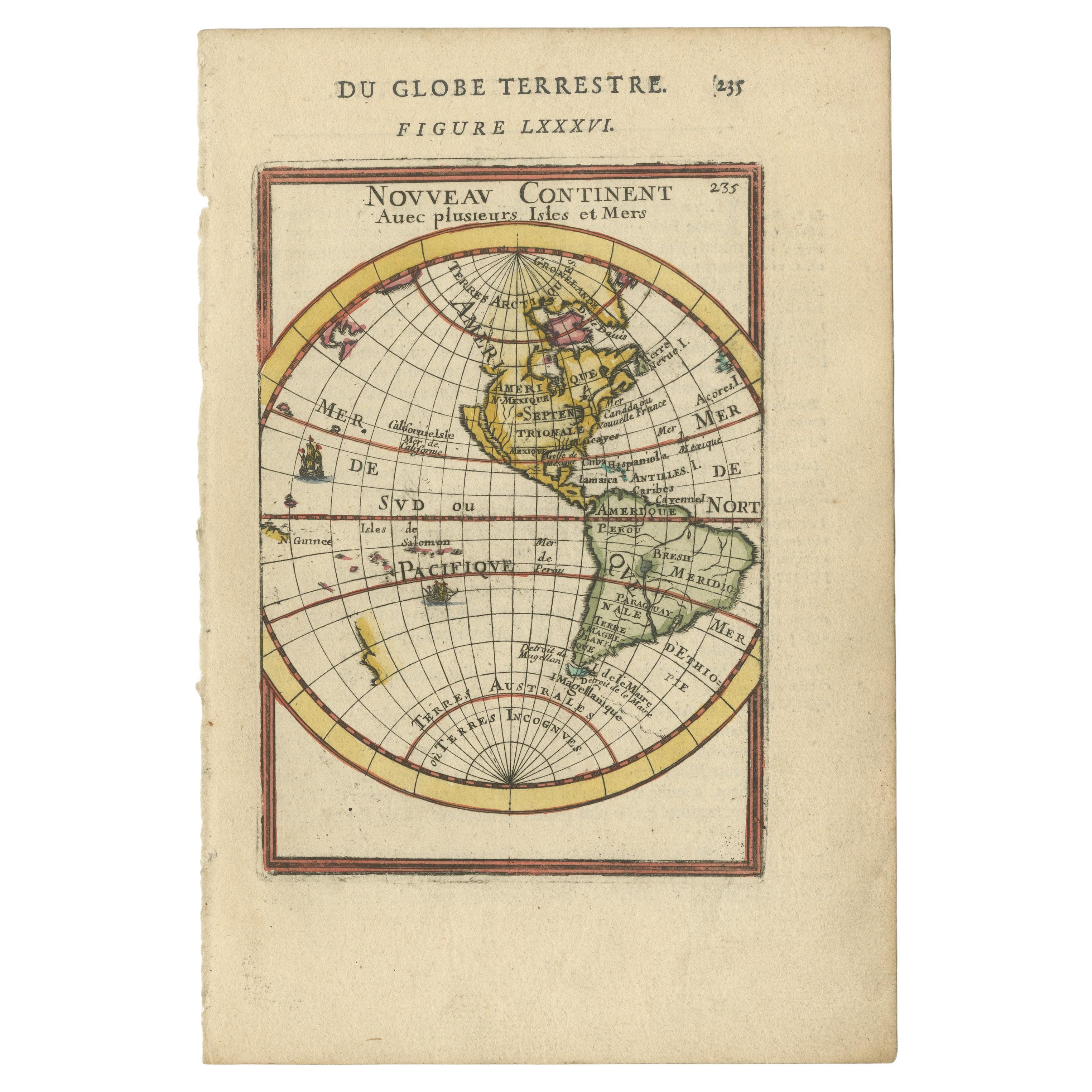
- Antique Miniature Map of the Western Hemisphere, with California as an IslandLocated in Langweer, NLAntique miniature map titled 'Nouveau Continent avec plusieurs Isles et Mers'. Decorative map of the Western Hemisphere, published by Alain Manesson Mallet. The map shows California as an Island...Category
Antique Late 17th Century Maps
MaterialsPaper


Recently Viewed
View AllMore Ways To Browse
Maps Tallis
Glass Store Cabinets
Metal Wall Sculpture Original
China Cabinet Drawer
Antique Tall Displays
Hardwood Door Used
Cream Drawers
Modern Chest Drawers Oak
Two Pairs Of Antique Doors
Pair Antique Shelves
French Canadian Antique
18th Century Painted Wood Panels
Swedish Gustavian Chests And Commodes
Modern Cabinet With Painted Drawers
Pair Double Doors
Clamp On
Antique French Painted Doors
Corner Cabinet Glass Door