Items Similar to Antique Map of British America by Tallis 'c.1850'


Want more images or videos?
Request additional images or videos from the seller
1 of 7
Antique Map of British America by Tallis 'c.1850'
About the Item
Antique map titled 'British America'. Decorative map of British America, with vignettes showing Whale Fishing, Montreal, Fury and Hecla ships asail. This map originates from 'The History and Topography of the United States of America: edited by John Howard Hinton, A.M'. Printed and published by John Tallis and Company, London and New York. Published circa 1850.
- Dimensions:Height: 10.44 in (26.5 cm)Width: 13.78 in (35 cm)Depth: 0.02 in (0.5 mm)
- Materials and Techniques:
- Period:
- Date of Manufacture:circa 1850
- Condition:General age-related toning, original folding line. Minor wear, blank verso. Please study image carefully.
- Seller Location:Langweer, NL
- Reference Number:
About the Seller
5.0
Platinum Seller
These expertly vetted sellers are 1stDibs' most experienced sellers and are rated highest by our customers.
Established in 2009
1stDibs seller since 2017
1,919 sales on 1stDibs
Typical response time: <1 hour
- ShippingRetrieving quote...Ships From: Langweer, Netherlands
- Return PolicyA return for this item may be initiated within 14 days of delivery.
More From This SellerView All
- Antique Map of West Canada by Tallis 'c.1850'Located in Langweer, NLAntique map titled 'West Canada'. Original antique map of West Canada, with decorative vignettes titled Kingston and Falls of Niagara. This map originates from 'The History and Topog...Category
Antique Mid-19th Century Maps
MaterialsPaper
- Antique Map of Switzerland by J. Tallis, circa 1851Located in Langweer, NLA decorative and detailed mid-19th century map of Switzerland which was drawn and engraved by J. Rapkin (vignettes by A. H. Wray & J. B. Allen) and published in John Tallis's Illustr...Category
Antique Mid-19th Century Maps
MaterialsPaper
- Antique Map of Belgium by J. Tallis, circa 1851Located in Langweer, NLA highly decorative and detailed mid-19th century map of Belgium which was drawn and engraved by J. Rapkin (vignettes by J. Marchant and J. B. Allen) an...Category
Antique Mid-19th Century Maps
MaterialsPaper
- Antique Map of the Northern Part of South America by J. Tallis, circa 1851Located in Langweer, NLA decorative and detailed mid-19th century map of the northern part of South America (including modern day Venezuela, Colombia, Ecuador, Guyana, Suriname and French Guiana) which was drawn and engraved by J. Rapkin (vignettes by H. Winkles & W. Lacey) and published in John Tallis & Co.'s The Illustrated Atlas (London & New York: circa 1851). The Illustrated Atlas, published from 1849 onwards, was the last decorative world atlas. The 'Venezuela, New Granada...' map was typical of the many Fine ones which appeared in this work with its decorative border and attractive vignettes. Illustrated are views of Mount Chimborazo, Ecuador; the 'Fall of the Bagota' (Tequendama Falls, Colombia); Rheas and a prospect of Paramaribo Harbour (Dutch Guiana...Category
Antique Mid-19th Century Maps
MaterialsPaper
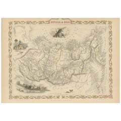
- Antique Map of Russia in Asia by Tallis, '1851'Located in Langweer, NLAntique map titled 'Russia in Asia'. Map of Russia in Asia. Showing vignettes of a polar hunting scene, Skorskarskoi Pagost, Troitsk and Kamchatkan Dogs. Originates from 'The Illustr...Category
Antique Mid-19th Century Maps
MaterialsPaper
- Antique Map of Russia in Europe by Tallis, '1851'Located in Langweer, NLAntique map titled 'Russia in Europe'. Map of European Russia. Showing vignettes of the Neoskoi Prospect, St. Petersburg, Polish Captives on their way to Siberia, a Russian Bear...Category
Antique Mid-19th Century Maps
MaterialsPaper


You May Also Like
- Original Antique Map of Belgium by Tallis, Circa 1850Located in St Annes, LancashireGreat map of Belgium Steel engraving Many lovely vignettes Published by London Printing & Publishing Co. ( Formerly Tallis ), C.1850 Origin...Category
Antique 1850s English Maps
MaterialsPaper
- Original Antique Map / City Plan of Brussels by Tallis, circa 1850Located in St Annes, LancashireGreat map of Brussels. Steel engraving. Published by London Printing & Publishing Co. (Formerly Tallis), C.1850 Free shipping.Category
Antique 1850s English Maps
MaterialsPaper
- Large Antique 1859 Map of North AmericaLocated in Sag Harbor, NYThis Map was made by Augustus Mitchell in 1859 It is in amazing condition for being 163 years old. This price is for the rolled up easy to ship version of this piece. I will be Frami...Category
Antique Mid-19th Century American Maps
MaterialsCanvas, Paper

- Original Antique Map of South America. C.1780Located in St Annes, LancashireGreat map of South America Copper-plate engraving Published C.1780 Two small worm holes to left side of map Unframed.Category
Antique Early 1800s English Georgian Maps
MaterialsPaper
- Original Antique Map of South America by Thomas Clerk, 1817Located in St Annes, LancashireGreat map of South America Copper-plate engraving Drawn and engraved by Thomas Clerk, Edinburgh. Published by Mackenzie And Dent, 1817 Unframed.Category
Antique 1810s English Maps
MaterialsPaper
- Original Antique Map of South America, circa 1830Located in St Annes, LancashireGreat map of South America Copper plate engraving Published by Butterworth, Livesey & Co., circa 1830 Unframed.Category
Antique Early 1800s English Other Maps
MaterialsPaper


