Items Similar to Comore Island Original Antique Engraving by Van Schley, 1749
Want more images or videos?
Request additional images or videos from the seller
1 of 5
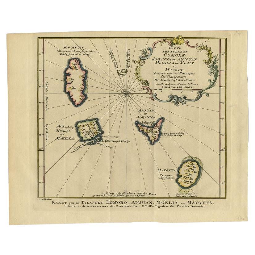
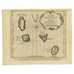
Comore Island Original Antique Engraving by Van Schley, 1749
About the Item
Antique map titled 'Carte des Isles de Comore Johanna ou Anouan Mohilla ou Moaly et Mayote (..) - Kaart van de Eilanden Komoro, Anjuan, Moelia, en Mayotta (..)'. Copper engraving of the Comoro Islands or Comoros. This map originates from 'Historische beschryving der reizen, of Nieuwe en volkoome verzameling van de aller-waardigste en zeldsaamste Zee- en Landtogten' by P. de Hondt.
Artists and Engravers: Engraved by Jakob van der Schley (Amsterdam 1715-1779), a Dutch draughtsman and engraver. He studied under Bernard Picart and became heavily influenced by his style.
We sell original antique maps to collectors, historians, educators and interior decorators all over the world. Our collection includes a wide range of authentic antique maps from the 16th to the 20th centuries. Buying and collecting antique maps is a tradition that goes back hundreds of years. Antique maps have proved a richly rewarding investment over the past decade, thanks to a growing appreciation of their unique historical appeal. Today the decorative qualities of antique maps are widely recognized by interior designers who appreciate their beauty and design flexibility. Depending on the individual map, presentation, and context, a rare or antique map can be modern, traditional, abstract, figurative, serious or whimsical. We offer a wide range of authentic antique maps for any budget.
- Dimensions:Height: 10.24 in (26 cm)Width: 11.3 in (28.7 cm)Depth: 0 in (0.01 mm)
- Materials and Techniques:Paper,Engraved
- Period:
- Date of Manufacture:1749
- Condition:Condition: Good, given age. Original folds as issued. General age-related toning and/or occasional minor defects from handling. Spot at the bottom of the print. Please study scan carefully.
- Seller Location:Langweer, NL
- Reference Number:
About the Seller
5.0
Platinum Seller
These expertly vetted sellers are 1stDibs' most experienced sellers and are rated highest by our customers.
Established in 2009
1stDibs seller since 2017
1,933 sales on 1stDibs
Typical response time: <1 hour
- ShippingRetrieving quote...Ships From: Langweer, Netherlands
- Return PolicyA return for this item may be initiated within 14 days of delivery.
More From This SellerView All
- Antique Map of the Main Comoro Islands by Van Schley, 1749By Jakob van der SchleyLocated in Langweer, NLAntique map titled ‘Carte des Isles de Comore (..) - Kaart van de Eilanden Komoro (..)’. Original antique map of the main Comoro Islands or Comoros including Comore, Mohéli, Anjouan ...Category
Antique 18th Century Maps
MaterialsPaper
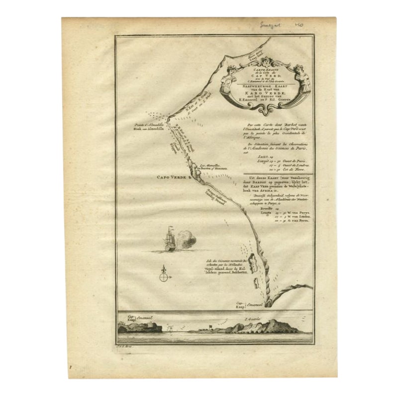
- The Cape Verde Islands Coast Antique Engraving by Van Schley, 1747Located in Langweer, NLAntique map titled ‘Carte Exacte de la cote du Cap Verd (..) - Naauwkeurige Kaart van de Kust van Kabo Verde (..)'. Original antique map of the coast of the Cape Verde Islands. This ...Category
Antique 18th Century Maps
MaterialsPaper
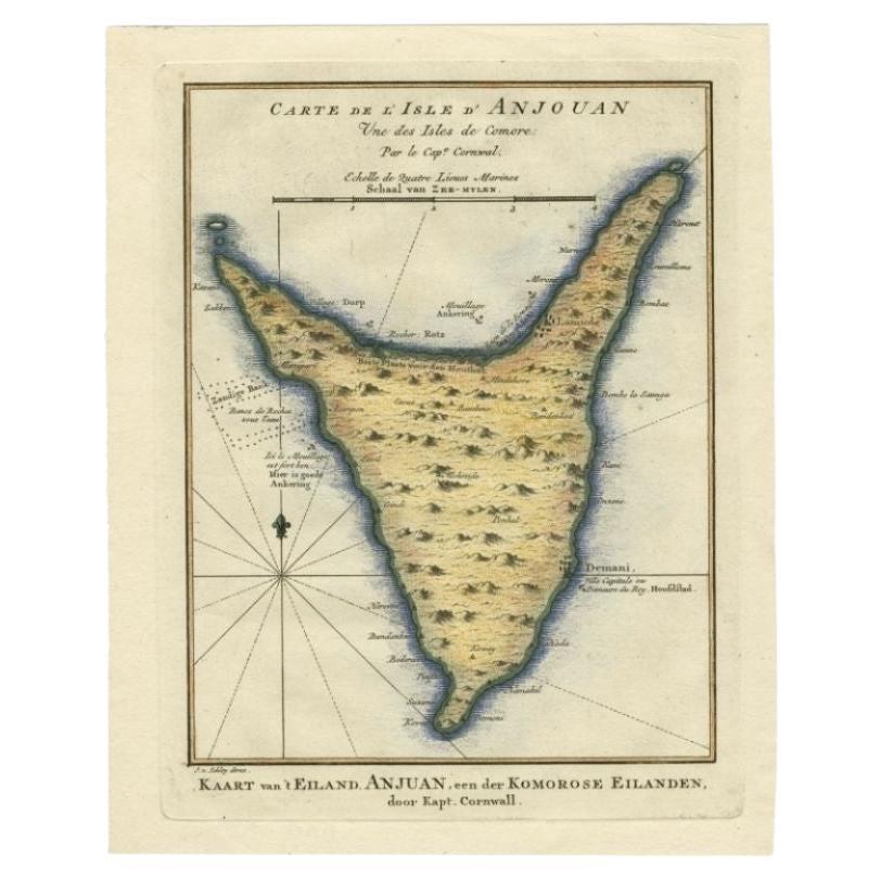
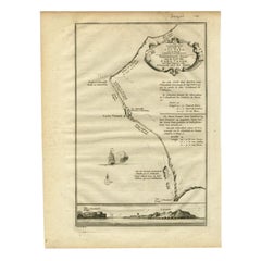
- Antique Map of the Island Anjouan by Van Schley, c.1750Located in Langweer, NLAntique map titled 'Carte de l'Isle d'Anjouan une des Isles de Comore'. Striking map of the Island Anjouan, part of the Comoros in the Indian Ocean by Nicolas Bellin. Source unknown,...Category
Antique 18th Century Maps
MaterialsPaper
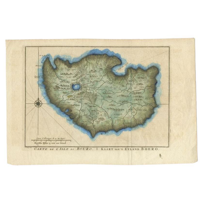
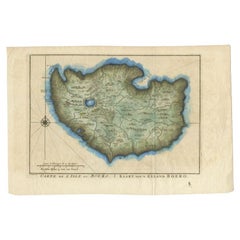
- Antique Map of the Island of Buru by Van Schley, 1755Located in Langweer, NLAntique map titled 'Carte de L'Isle de Bouro - Kaart van 't Eyland Boero'. This map depicts the island of Buru, Maluku, Indonesia. Originates from the Dutch edition of 'Histoire Gene...Category
Antique 18th Century Maps
MaterialsPaper
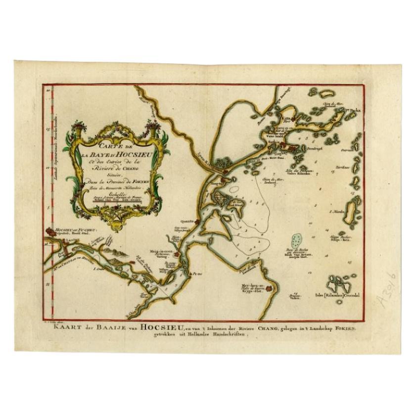
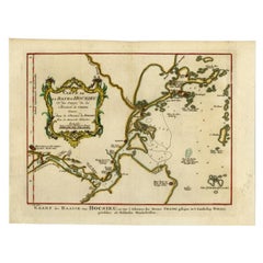
- Antique Map of the Bay Near Huchou Island by Van Schley, 1758Located in Langweer, NLAntique map titled 'Carte de la Baye d' Hocsieu et des entrees de la Riviere de Chang situees dans la Province de Foyken.' Original antique map of the bay nea...Category
Antique 18th Century Maps
MaterialsPaper
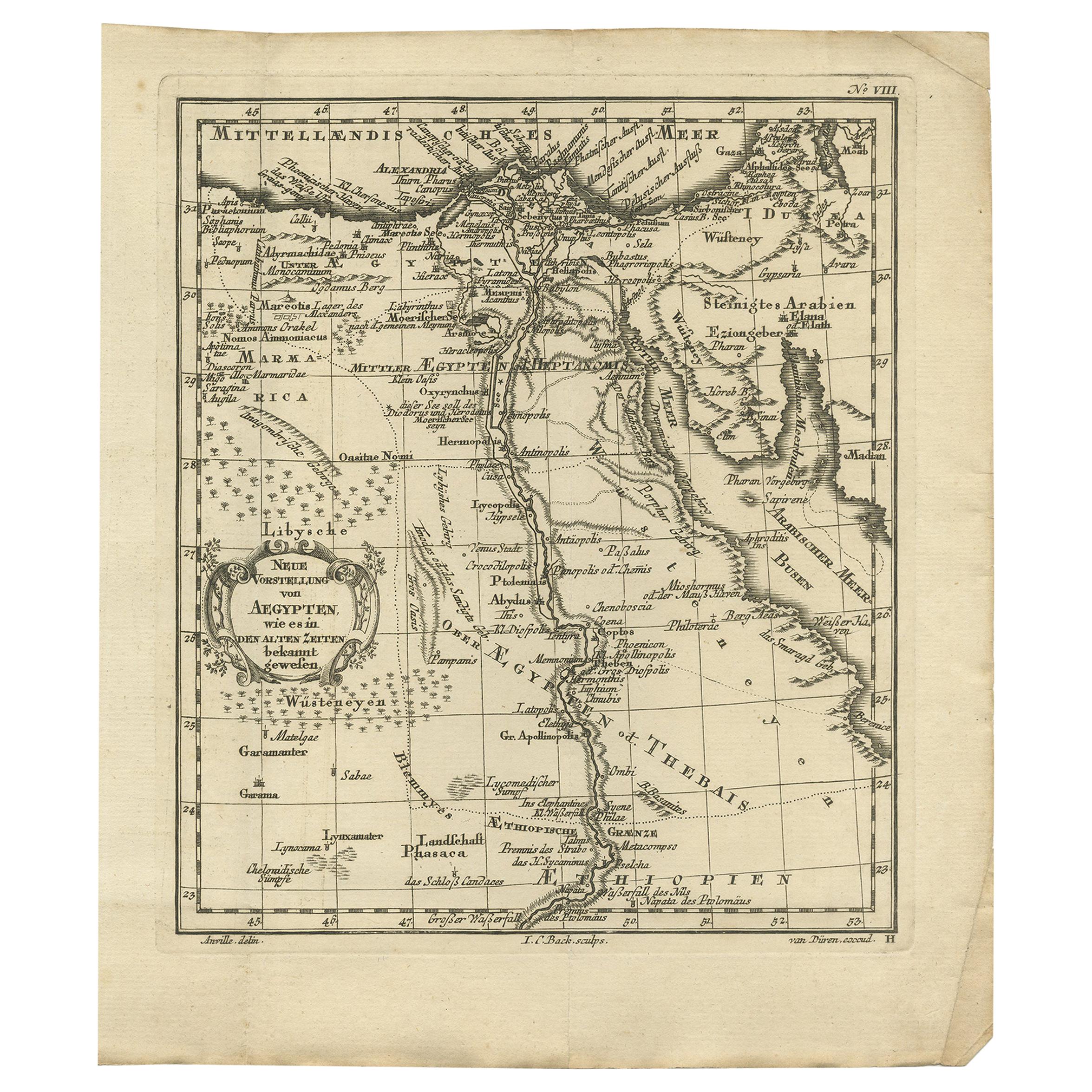
- Original Antique Map of Egypt by Van Dùren '1749'Located in Langweer, NLDecorative German antique engraving with titled 'Neue Vorstellung von Aegypten (..)'. It concerns a rare original antique map of Egypt. This map o...Category
Antique Mid-18th Century Maps
MaterialsPaper


You May Also Like
- Large Original Antique Map of Rhode Island, USA, C.1900Located in St Annes, LancashireFabulous map of Rhode Island Original color Engraved and printed by the George F. Cram Company, Indianapolis. Published, C.1900 Unframed Free ...Category
Antique 1890s American Maps
MaterialsPaper
- 1864 "Proclamation of Emancipation, " Antique Engraving by Charles ShoberLocated in Colorado Springs, COThis 1865 engraving features the Emancipation Proclamation in elaborate calligraphic text, with five patriotic vignettes and a small portrait...Category
Antique 1860s American Historical Memorabilia
MaterialsPaper
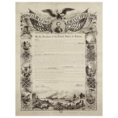
- 1864 Abraham Lincoln's Emancipation Proclamation, Antique Engraving by W RobertsLocated in Colorado Springs, COPresented is a Proclamation of Emancipation wood engraving by W. Roberts. The engraving was published in 1864, just one year after President Abraham Lincoln signed the original Proclamation. W. Roberts was the artist and engraver and Corydon Alexis Alvord was the printer. The engraving was published by R. A Dimmick, in New York, 1864. The text of the Proclamation is set in a variety of typefaces, which is encased in a pictorial border. The border is decorated with a portrait of Abraham Lincoln and seven other vignettes, including the horrors of slavery at left, the bombardment of Fort Sumter at bottom, and scenes from a prosperous and united nation at right. On September 22, 1862, five days after the Union victory at the Battle of Antietam, Lincoln issued a preliminary decree stating that, unless the rebellious states returned to the Union by January 1, freedom would be granted to slaves within those states. No Confederate states took the offer, and on January 1, 1863 Lincoln presented the Emancipation Proclamation...Category
Antique 1860s American Historical Memorabilia
MaterialsPaper
- Antique Lithograph of Christ on the Cross, Original Painting by Anthony Van DyckLocated in Lisse, NLAmazing lithograph of a 1630 van Dyck painting by lithographer L. van den Wildenbergh (1803-1857). The original painting of this rare antique lithograph (in its original early 19t...Category
Antique Early 19th Century Belgian Empire Revival Drawings
MaterialsWrought Iron, Copper
- George Washington by Henry Sadd, Antique Engraving, circa 1844Located in Colorado Springs, COThis is an 1844 engraving of President George Washington. The print was issued by G. Stuart in Albion, New York and engraved by H. S. Sadd. This standing portrait shows President George Washington in front of neoclassical columns. In his right hand, he holds a dress sword...Category
Antique 1840s American Prints
MaterialsPaper
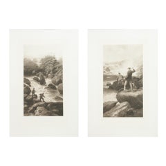
- Antique Pair of Salmon Fishing Engravings by George EarlBy George EarlLocated in Oxfordshire, GBPair of salmon fishing pictures, fishing & poaching. A large pair of goupilgravures, fishing and poaching, by George Earl. The pair of angling pictures ti...Category
Antique Early 1900s English Sporting Art Sports Equipment and Memorabilia
MaterialsPaper


Recently Viewed
View AllMore Ways To Browse
Antique Dutch Copper
World Maps Antique Style
World Map Antique Style
Antique Style Map Of The World
World Map Copper
Scan Style
Van Der Zee
Rare Johanna
Premier Antiques
18th Century Compass
Compass 18th Century
Antique Furniture Building Plans
Antique Spain Map
Large City Maps
Spain Antique Map
Military Map
Antique Maps Of Spain
Antique Map Of Spain