Items Similar to Antique Map of the City of Hindeloopen by Braun & Hogenberg, c.1598

Want more images or videos?
Request additional images or videos from the seller
1 of 5
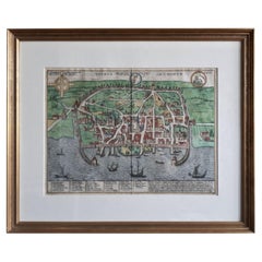
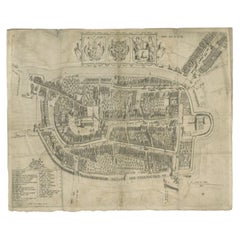
Antique Map of the City of Hindeloopen by Braun & Hogenberg, c.1598
About the Item
Antique map titled 'Hindelopia'. Original antique map of the city of Hindeloopen, Friesland, the Netherlands. Originally published on one sheet together with other Frisian cities, trimmed. This print originates from the town atlas by Braun and Hogenberg.
Artists and Engravers: Georg Braun (1542-1622), a German publisher and Frans Hogenberg issued the famous six volume town book ""Civitates Orbis Terrarum"" between 1572 and 1618. The volumes originally published in Latin, follow by German and French translations. Franz Hogenberg (1533-1588) was the son of a Munich engraver who settled in Malines. He engraved most of the plates for Ortelius' Theatrum and the majority of those in the Civitates, and may have been responsible for originating the project. Worked and died in Cologne/Germany. He was a prolific copper engraver and etching artist of maps and town views. In cooperation with Georg Braun he created the first four volumes of the Civitates Orbis Terrarum in 1572.
Condition: Good, general age-related toning. Passe-partout/matting included. Please study image carefully.
Date: c.1598
Overall size: 28.3 x 25.2 cm.
We sell original antique maps to collectors, historians, educators and interior decorators all over the world. Our collection includes a wide range of authentic antique maps from the 16th to the 20th centuries. Buying and collecting antique maps is a tradition that goes back hundreds of years. Antique maps have proved a richly rewarding investment over the past decade, thanks to a growing appreciation of their unique historical appeal. Today the decorative qualities of antique maps are widely recognized by interior designers who appreciate their beauty and design flexibility. Depending on the individual map, presentation, and context, a rare or antique map can be modern, traditional, abstract, figurative, serious or whimsical. We offer a wide range of authentic antique maps for any budget
- Dimensions:Height: 9.93 in (25.2 cm)Width: 11.15 in (28.3 cm)Depth: 0 in (0.01 mm)
- Materials and Techniques:
- Period:
- Date of Manufacture:circa 1598
- Condition:
- Seller Location:Langweer, NL
- Reference Number:
About the Seller
5.0
Platinum Seller
These expertly vetted sellers are 1stDibs' most experienced sellers and are rated highest by our customers.
Established in 2009
1stDibs seller since 2017
1,932 sales on 1stDibs
Typical response time: <1 hour
- ShippingRetrieving quote...Ships From: Langweer, Netherlands
- Return PolicyA return for this item may be initiated within 14 days of delivery.
More From This SellerView All
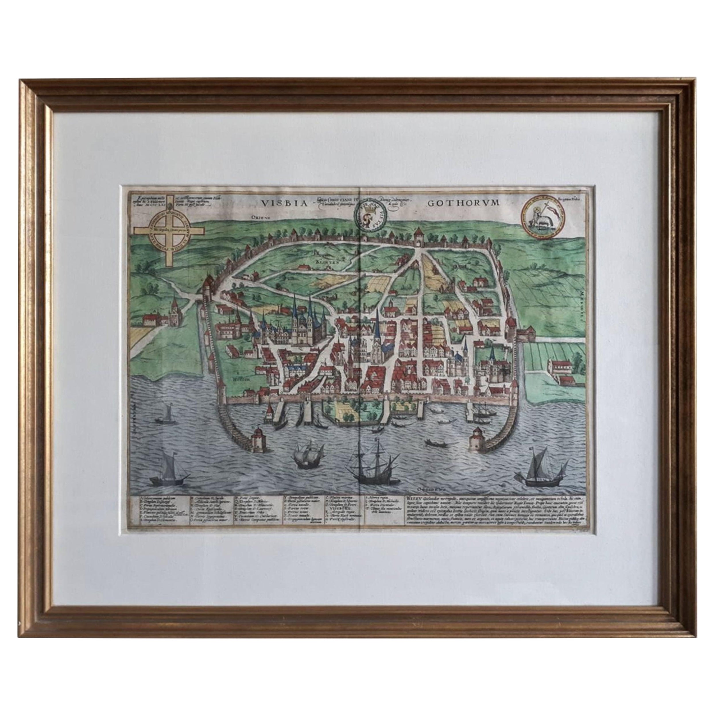
- Antique Map of the City of Visby 'Sweden' by F. Hogenberg, 1598Located in Langweer, NLThis is a wonderful bird's-eye plan/view of the oldest city in Sweden. Visby, the largest city on the island of Gotland was an important Viking city and the main centre of the Ha...Category
Antique 16th Century Maps
MaterialsPaper
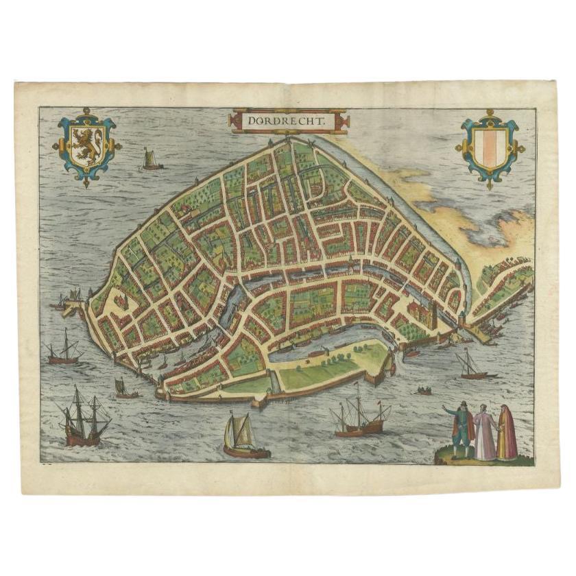
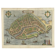
- Antique Map of the City of Dordrecht by Braun & Hogenberg, c.1581Located in Langweer, NLAntique map titled 'Dordrecht'. Map of the city of Dordrecht, the Netherlands. Bird's-eye plan view of the city, with many ships and two coats of arms in upper corners. This map orig...Category
Antique 16th Century Maps
MaterialsPaper
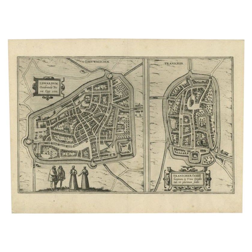
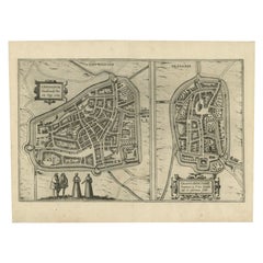
- Antique Map of the City of Leeuwarden and Franeker by Braun & Hogenberg, 1580Located in Langweer, NLAntique map titled 'Lewardum Occidentlis Frisiae Opp: 1580, Franicher Nobiliu hominum, in Frisia Occidentali, ut plurimum saedes'. This sheet contains two very detailed bird’s-eye pl...Category
Antique 16th Century Maps
MaterialsPaper
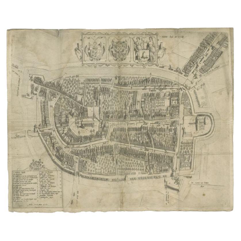
- Antique Map of the City of Franeker by Bast, 1598Located in Langweer, NLAntique map titled 'Franeker'. Very rare and early map of the city of Franeker, Friesland. With decorative cartouche and Dutch legend. Artists and Engravers: Pieter Bast (1550-1605) ...Category
Antique 16th Century Maps
MaterialsPaper
- Antique Map of Douai 'France' by Braun & Hogenberg, circa 1575Located in Langweer, NLBeautiful map in excellent condition. This map depicts the city of Douai (France) and originates from 'Civitates Orbis Terrarum'.Category
Antique 16th Century Maps
MaterialsPaper
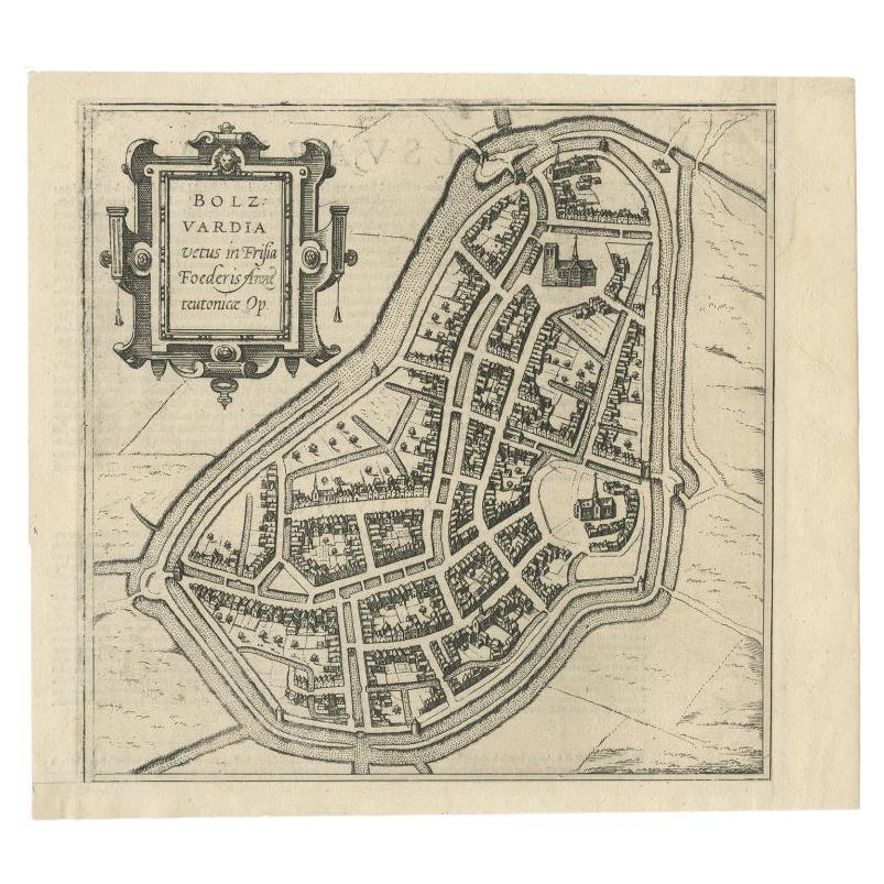
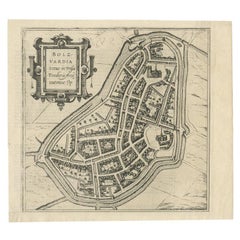
- Antique Map of the City of Bolsward, Friesland in The Netherlands, c.1598Located in Langweer, NLAntique map titled ‘Bolzvardia vetus in Frisia Foederis (..)’. Old map of the city of Bolsward, Friesland. Originally part of a sheet together with the cities of Stavoren, Harlingen ...Category
Antique 16th Century Maps
MaterialsPaper

You May Also Like
- 1840 Map of the City of Washington Published by William M. MorrisonLocated in Colorado Springs, COThis map, printed in 1840, is a detailed representation of Washington, D.C. in the mid-19th century. The map shows block numbers, wards, and government buildings as well as details o...Category
Antique 1840s American Federal Maps
MaterialsPaper
- 1861 Topographical Map of the District of Columbia, by Boschke, Antique MapLocated in Colorado Springs, COPresented is an original map of Albert Boschke's extremely sought-after "Topographical Map of the District of Columbia Surveyed in the Years 1856 ...Category
Antique 1860s American Historical Memorabilia
MaterialsPaper
- Antique Map of American Cities, Vignette of New York City, circa 1920Located in St Annes, LancashireGreat maps of American Cities Unframed Original color By John Bartholomew and Co. Edinburgh Geographical Institute Published, circa 1920Category
Vintage 1920s British Maps
MaterialsPaper
- Original Antique Map / City Plan of Brussels by Tallis, circa 1850Located in St Annes, LancashireGreat map of Brussels. Steel engraving. Published by London Printing & Publishing Co. (Formerly Tallis), C.1850 Free shipping.Category
Antique 1850s English Maps
MaterialsPaper
- Italian Parchment Map of the City of Pisa Dated, 1640By Matthäus Merian the ElderLocated in Roma, ITAn antique map of the Tuscan city of Pisa engraved for The 'Itinerarium Italiæ Nov-antiquæ' by Matthäus Merian the Elder and printed in 1640....Category
Antique 1640s Italian Maps
MaterialsPaper
- Italian Parchment Map of the City of Lucca Dated 1640By Matthäus Merian the ElderLocated in Roma, ITAn antique map of the Tuscan city of Lucca engraved for The 'Itinerarium Italiæ Nov-antiquæ' by Matthäus Merian the Elder and printed in 1640...Category
Antique 1640s Italian Maps
MaterialsParchment Paper, Paper


Recently Viewed
View AllMore Ways To Browse
Antique City Views
Copper Map Plate
French Matting
Latin Book
Braun Modern
Braun Germany
World Map Copper
Orbis Copper
Antique Maps Ortelius
Antique Map Ortelius
Hindeloopen Furniture
Tree Bag
16th Century Scotland
Great Britain Maps
Used Furniture Depot
World Map British
Copper Map Plate
Swiss Antiques And Collectables