Items Similar to Antique Map of Great Britain and Ireland by Brion de la Tour, 1766


Want more images or videos?
Request additional images or videos from the seller
1 of 5
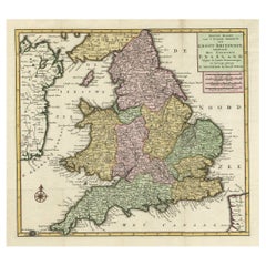
Antique Map of Great Britain and Ireland by Brion de la Tour, 1766
About the Item
Antique map titled 'Les Isles Britanniques (..).'
Attractive map of Great Britain surrounded by an engraved border printed from a separate copper plate.
Source unknown, to be determined. Artists and Engravers: Made by 'Louis Brion de la Tour' after 'Louis Charles Desnos'. Made by 'Louis Brion de la Tour ' after 'Louis-Charles Desnos'. Louis Brion de la Tour (1756 - 1823) was a Ingenieur-Geographe du Roi. De la Tour was one of the leading cartographers, his work was produced in collaboration with Louis-Charles Desnos (1750-1790) a Danish royal cartographer publisher.
Artist: Made by 'Louis Brion de la Tour' after 'Louis Charles Desnos'. Made by 'Louis Brion de la Tour ' after 'Louis-Charles Desnos'. Louis Brion de la Tour (1756 - 1823) was a Ingenieur-Geographe du Roi. De la Tour was one of the leading cartographers, his work was produced in collaboration with Louis-Charles Desnos (1750-1790) a Danish royal cartographer publisher.
Condition: Good, given age. Light browning and some spots in the margins. Original middle fold as issued. General age-related toning and/or occasional minor defects from handling. Please study image carefully.
Date: 1766
Overall size: 38 x 29.3 cm.
Image size: 30 x 27.5 cm.
We sell original antique maps to collectors, historians, educators and interior decorators all over the world. Our collection includes a wide range of authentic antique maps from the 16th to the 20th centuries. Buying and collecting antique maps is a tradition that goes back hundreds of years. Antique maps have proved a richly rewarding investment over the past decade, thanks to a growing appreciation of their unique historical appeal. Today the decorative qualities of antique maps are widely recognized by interior designers who appreciate their beauty and design flexibility. Depending on the individual map, presentation, and context, a rare or antique map can be modern, traditional, abstract, figurative, serious or whimsical. We offer a wide range of authentic antique maps for any budget.
- Dimensions:Height: 11.54 in (29.3 cm)Width: 14.97 in (38 cm)Depth: 0 in (0.01 mm)
- Materials and Techniques:
- Period:
- Date of Manufacture:1766
- Condition:
- Seller Location:Langweer, NL
- Reference Number:
About the Seller
5.0
Platinum Seller
These expertly vetted sellers are 1stDibs' most experienced sellers and are rated highest by our customers.
Established in 2009
1stDibs seller since 2017
1,919 sales on 1stDibs
Typical response time: <1 hour
- ShippingRetrieving quote...Ships From: Langweer, Netherlands
- Return PolicyA return for this item may be initiated within 14 days of delivery.
More From This SellerView All
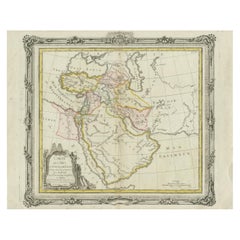
- Antique Map of the Middle East by Brion de la Tour '1772'Located in Langweer, NLAntique map titled 'Carte des Pays et Principaux Lieux (..)'. Original antique map of Middle East, extending to the Red Sea, Egypt, the Eastern Medi...Category
Antique Late 18th Century Maps
MaterialsPaper
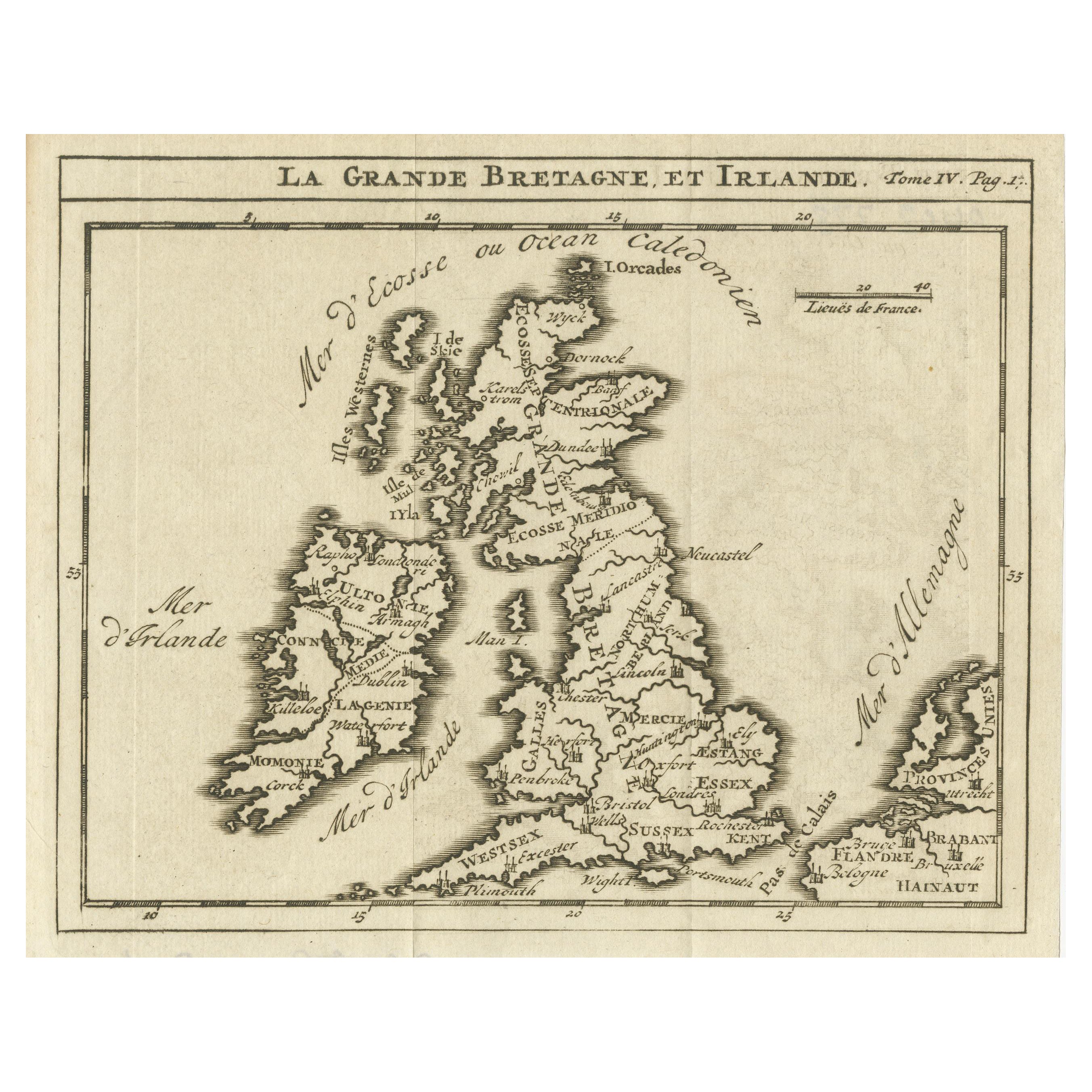
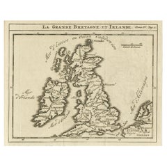
- Rare Small Antique Map of Great Britain and IrelandLocated in Langweer, NLAntique map titled 'La Grande Bretagne et Irlande'. Small antique map of Great Britain and Ireland. Source unknown, to be determined. Publ...Category
Antique Mid-18th Century Maps
MaterialsPaper
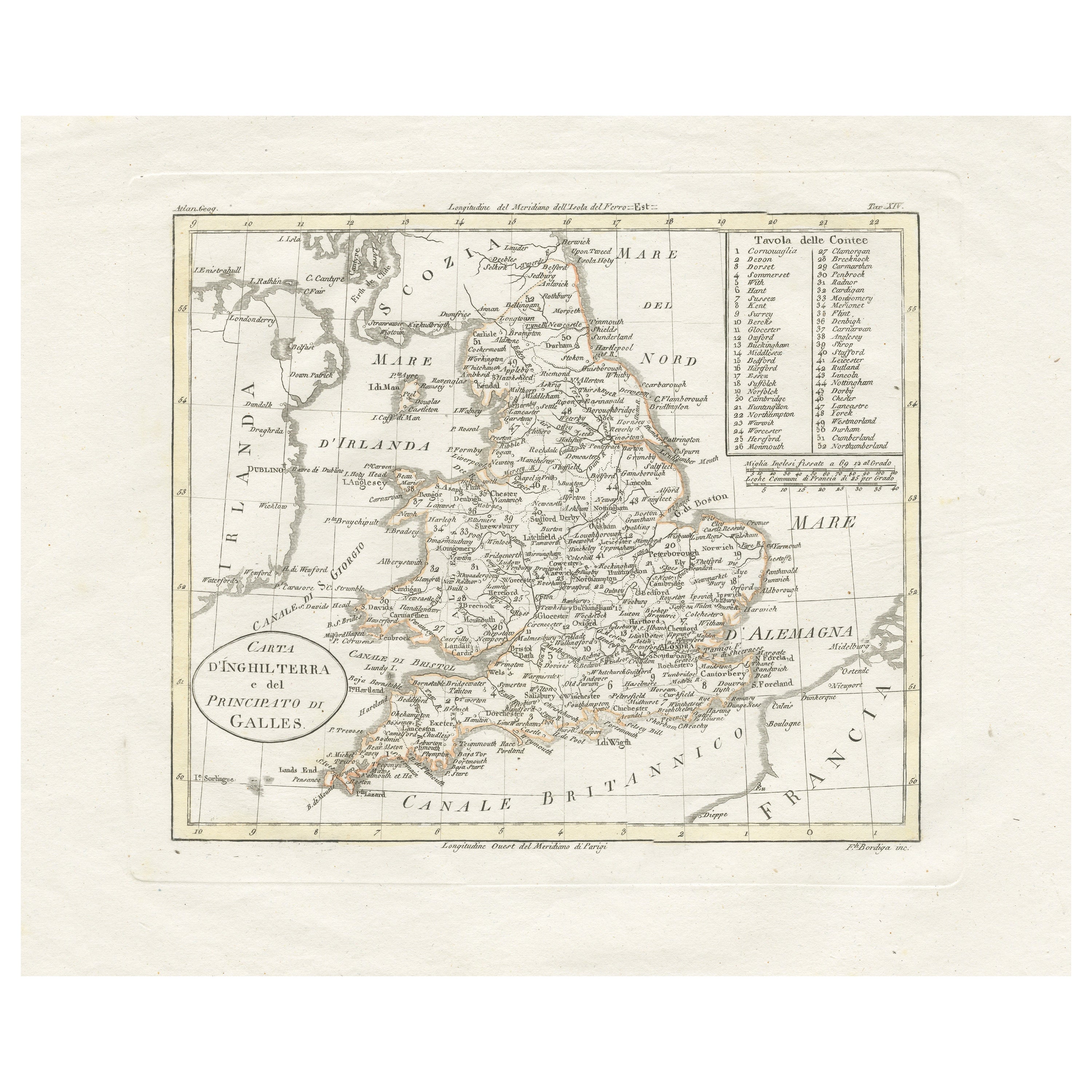
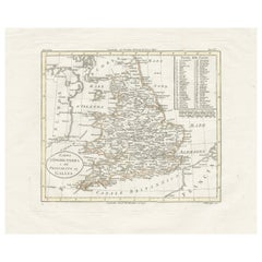
- Detailed Antique Map of Britain, Wales and the Coast of IrelandLocated in Langweer, NLAntique map titled 'Carta d'Inghilterra e del Principato di Galles'. Detailed map of Britain, Wales and the coast of Ireland with a list of counties. This map originates from 'Nuovo ...Category
Antique Mid-19th Century Maps
MaterialsPaper
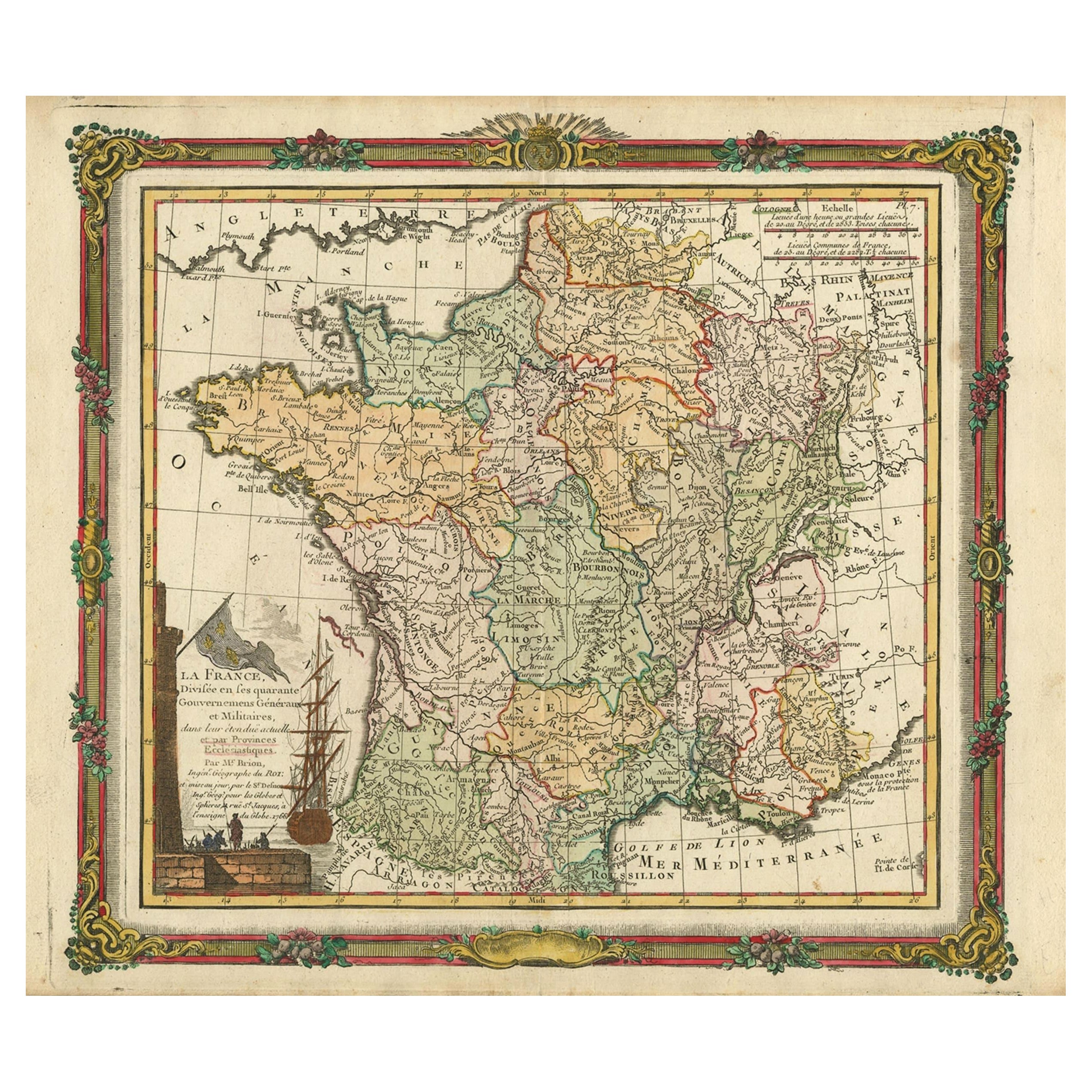
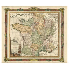
- Antique Map of France with Decorative Border, 1766Located in Langweer, NLAntique map titled 'La France, divisée en ses quarante Gouvernemens Généraux.' Attractive map of France by Brion de la Tour, published by Desnos. The decorative border was printed fr...Category
Antique 18th Century Maps
MaterialsPaper
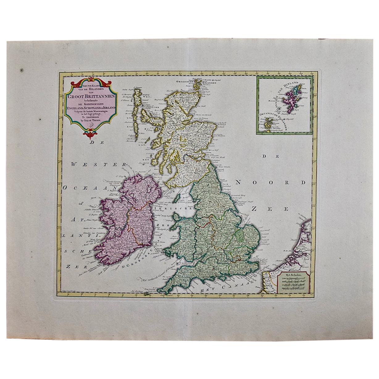
- Antique Map of the South Part of Great Britain by Tirion, c.1750By Isaak TirionLocated in Langweer, NLAntique map titled 'Nieuwe Kaart van 'T Zuider Gedeelte van Groot Britannie behelzende Het Koningryk Engeland (..).' Attractive map showing the south part of Great Britain; the K...Category
Antique 18th Century Maps
MaterialsPaper
- Antique Map of South America by De la Harpe '1780'Located in Langweer, NLAntique map titled 'Carte de l'Amerique Méridionale'. Original antique map of South America. Note the 'Laguna de Xarayes' is illustrated as the source of the Paraguay river. The laguna is now known as Pantanal, world's largest tropical wetland area. This map orginates from 'Abrégé de l'histoire générale des Voyages' by J.F. de la Harpe.Category
Antique Late 18th Century Maps
MaterialsPaper

You May Also Like
- England, Scotland & Ireland: A Hand Colored Map of Great Britain by TirionBy Isaak TirionLocated in Alamo, CAThis is a hand-colored double page copperplate map of Great Britain entitled "Nieuwe Kaart van de Eilanden van Groot Brittannien Behelzende de Kon...Category
Antique Mid-18th Century Dutch Maps
MaterialsPaper
- Original Antique Map of Ireland- Tipperary and Waterford. C.1840Located in St Annes, LancashireGreat map of Tipperary and Waterford Steel engraving Drawn under the direction of A.Adlard Published by How and Parsons, C.1840 Unframed.Category
Antique 1840s English Maps
MaterialsPaper
- Original Antique Map of Ireland- Kerry. C.1840Located in St Annes, LancashireGreat map of Kerry Steel engraving Drawn under the direction of A.Adlard Published by How and Parsons, C.1840 Unframed.Category
Antique 1840s English Maps
MaterialsPaper
- Large 17th Century Hand Colored Map of England and the British Isles by de WitBy Frederick de WitLocated in Alamo, CAA large hand colored 17th century map of England and the British Isles by Frederick de Wit entitled "Accuratissima Angliæ Regni et Walliæ Principatus", published in Amsterdam in 1680. It is a highly detailed map of England, Scotland, the Scottish Isles...Category
Antique Late 17th Century Dutch Maps
MaterialsPaper
- Map of the Holy Land "Carte de la Syrie et de l'Egypte" by Pierre M. LapieBy Pierre M. LapieLocated in Alamo, CAAn early 19th century map of ancient Syria and Egypt entitled "Carte de la Syrie et de l'Egypte anciennes/dressée par M. Lapie, Colonel d'Etat Major, et...Category
Antique Early 19th Century French Maps
MaterialsPaper
- Southeastern Ireland: A 17th Century Hand Colored Map by Mercator and HondiusBy Gerard MercatorLocated in Alamo, CAA 17th century copperplate hand-colored map entitled "The Second Table of Ireland, Udrone" by Gerard Mercator and Jodocus Hondius, published in Amsterdam in 1635 in 'Cosmographicall ...Category
Antique Mid-17th Century Dutch Maps
MaterialsPaper


Recently Viewed
View AllMore Ways To Browse
Antique British Plates
Danish Modern La
Royal British Antiques
Ireland Plate
Irish Plates
Antique British Maps
Antique Maps Of Britain
Great Britain Maps
World Map British
Copper Map Plate
Antique Britain Map
Antique Map Britain
18th Century British Antique Print
Denmark Maps
Denmark Map
Ireland Map
Irish Map
Map Of Ireland