Items Similar to Handsome Old Detailed Map of the Low Countries by Famous Mapmaker Blaeu, ca.1635


Want more images or videos?
Request additional images or videos from the seller
1 of 5
Handsome Old Detailed Map of the Low Countries by Famous Mapmaker Blaeu, ca.1635
About the Item
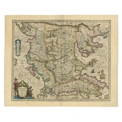
Antique map titled 'Novus XVII Inferioris Germaniae Provinciarum Typus'.
Handsome - and much sought after- detailed map of the Low Countries by the world most famous map maker Blaeu. With beautiful cartouches, coat of arms, compass rose, scale and many ships on the North Sea. Willem Blaeu published this map in 1608 as a wall map with figured borders. Later, in 1630, he needed a general map of the Netherlands for his first atlas, the Appendix, the decoration in the borders was sacrificed: the borders of the copper plates were cut off. It is one of the most decorative maps of present Netherlands, Belgium and Luxembourg. Still with the signature of "Willem Janszoon op't Water in de Vergulde Zonnewyzer." Spanish text on verso. Published circa 1635.
Artists and Engravers: The Blaeu firm was founded in 1596 by Willem Janzoon Blaeu (1571-1638). It was in this initial period, from 1596 to 1672, under the leadership of Willem Blaeu and with this assistance of his two talented sons Cornelius (1616-1648) and Johannis (1596-1673), that the firm was most active. Their greatest cartographic achievement was the publication of the magnificent multi-volume Atlas Major.
Condition: Good, given age. Minimal paper separation bottom middle fold, not affecting image. Some spots in the margins. Original middle fold as issued. General age-related toning and/or occasional minor defects from handling. Spanish text on verso. Please study image carefully.
- Dimensions:Height: 17.72 in (45 cm)Width: 23.12 in (58.7 cm)Depth: 0 in (0.02 mm)
- Materials and Techniques:
- Period:1630-1639
- Date of Manufacture:circa 1635
- Condition:
- Seller Location:Langweer, NL
- Reference Number:
About the Seller
5.0
Platinum Seller
These expertly vetted sellers are 1stDibs' most experienced sellers and are rated highest by our customers.
Established in 2009
1stDibs seller since 2017
1,932 sales on 1stDibs
Typical response time: <1 hour
- ShippingRetrieving quote...Ships From: Langweer, Netherlands
- Return PolicyA return for this item may be initiated within 14 days of delivery.
More From This SellerView All
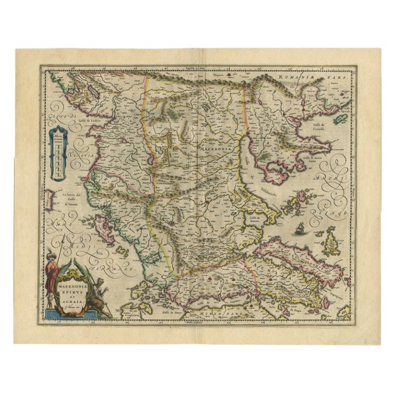
- Antique Map of Macedonia by the Famous Mapmaker Blaeu, c.1650Located in Langweer, NLAntique map titled 'Macedonia, Epirus et Achaia'. Ornated with a nice allegoric cartouche, one ship and a milage scale. Macedonia is shown in the centre of the map. With many detai...Category
Antique 17th Century Maps
MaterialsPaper
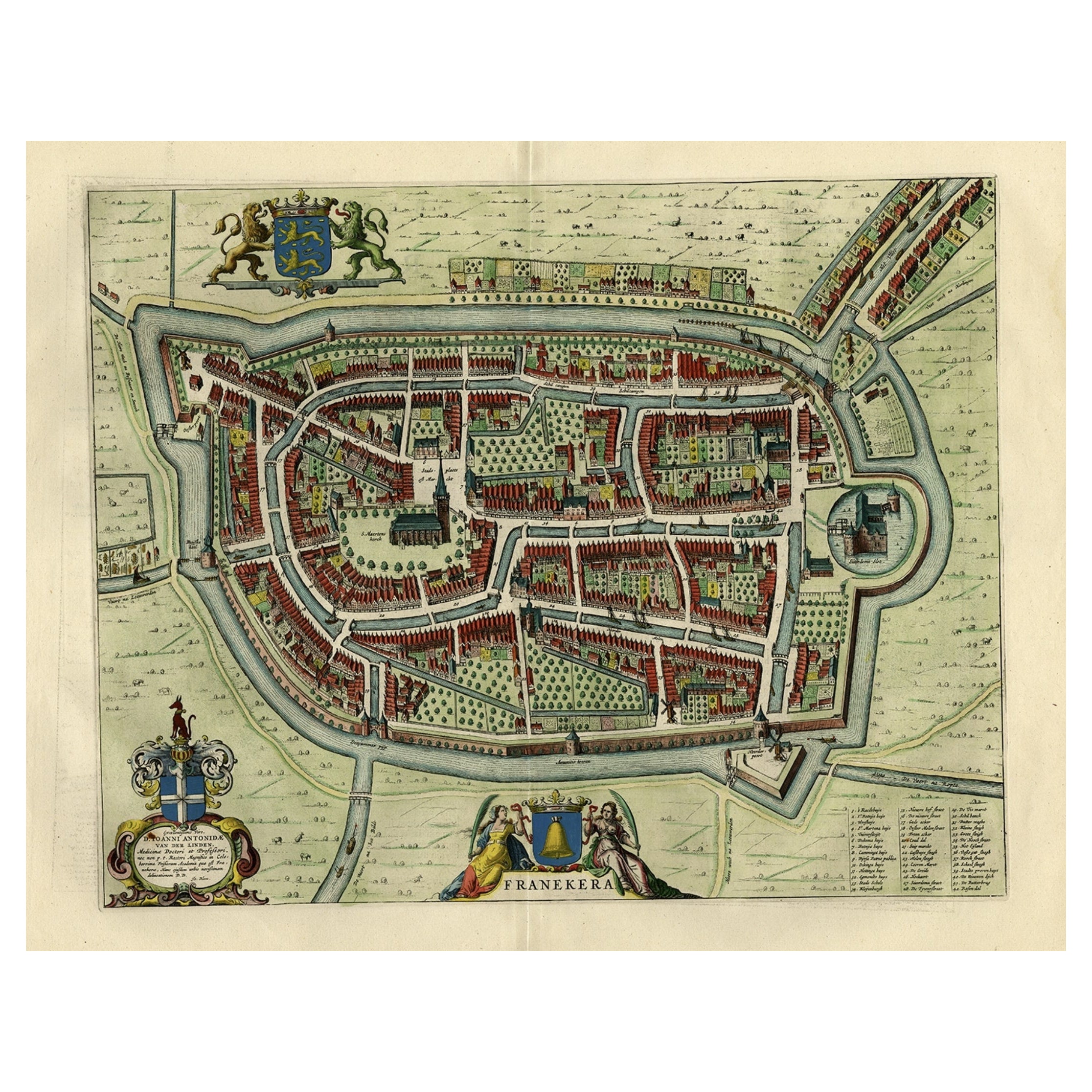
- Old Map of the City of Franeker, Friesland by the Famous Mapmaker Blaeu, 1652Located in Langweer, NLAntique map titled 'Franekera'. Old map of the city of Franeker, Friesland. Also shows two cartouches, coats of arms and legend. This map originates from a Latin edition of the town ...Category
Antique 1650s Maps
MaterialsPaper
- Antique Map of Lower Silesia of The Famous Mapmaker Blaeu, c.1650Located in Langweer, NLAntique map titled 'Ducatus Silesiae Wolanus'. \ Antique map depicting lower Silesia with the cities of Wolow (Wohlau), Winsko (Winzig), Herrnstadt, Chobie (Koben), Lubin (Lüben), R...Category
Antique 17th Century Maps
MaterialsPaper
- Antique Map of Artois in the North of France by Famous Mapmaker Blaeu, c.1640Located in Langweer, NLAntique map titled 'Artesia Comitatus Artois'. Map of Artois or Artesia, France. Artois is former province located in the northwestern part of France, boarding Belgium (Flanders) on ...Category
Antique 17th Century Maps
MaterialsPaper
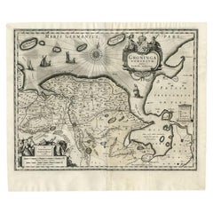
- Antique Map of the Province of Groningen by Blaeu, 1635Located in Langweer, NLAntique map titled 'Groninga Dominium.' A map of the Dutch province Groningen. This includes the Wadden islands Schiermonnikoog, Rottumeroog (Rottumerplaat) and Borkum. With compass ...Category
Antique 17th Century Maps
MaterialsPaper
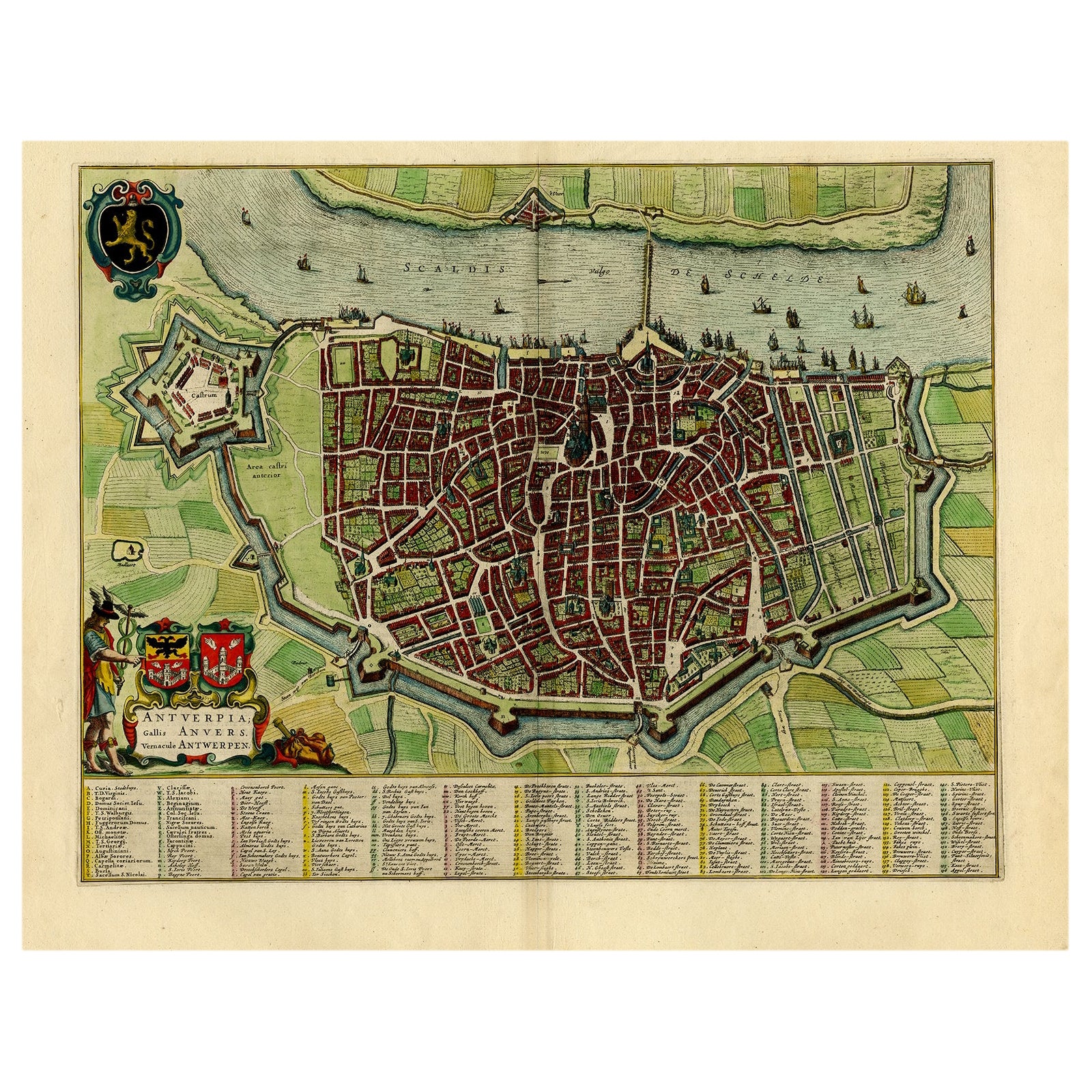
- Beautiful Original Antique Map of Antwerp, Belgium by Mapmaker Blaeu, ca.1652Located in Langweer, NLDescription: Antique map titled 'Antverpia; Gallis Anvers. Vernacule Antwerpen.' A very nicely coloured plan of Antwerp in Flanders, Belgium. West-oriented, with the river Scheld...Category
Antique 1650s Maps
MaterialsPaper
You May Also Like
- World Map Silver Leaf Print Based on Original Willem Blaeu Wall Map 1571-1638Located in GBWe are delighted to offer for sale this lovely Antique style pictorial plan map of the globe based on the original Willem Blaeu 1571-1638 engraved in silver leaf foil This is a v...Category
20th Century English Campaign Maps
MaterialsSilver Leaf
- Gold Leaf Foil Pictorial Plan Map of the West Country of England Antique StyleLocated in GBWe are delighted to offer for sale this lovely Antique style pictorial plan map of the West Country of England etched in gold leaf foil This is a very interesting and decorative p...Category
20th Century English Adam Style Maps
MaterialsGold Leaf
- Large Original Antique Map of The West Indies by Sidney Hall, 1847Located in St Annes, LancashireGreat map of The West Indies Drawn and engraved by Sidney Hall Steel engraving Original colour outline Published by A & C Black. 1847 Unframed Free shipping.Category
Antique 1840s Scottish Maps
MaterialsPaper
- Original Antique Map of the American State of Washington, 1889Located in St Annes, LancashireGreat map of Washington Drawn and Engraved by W. & A.K. Johnston Published By A & C Black, Edinburgh. Original colour Unframed.Category
Antique 1880s Scottish Victorian Maps
MaterialsPaper
- Original Antique Map of the American State of Nevada, 1889Located in St Annes, LancashireGreat map of Nevada Drawn and Engraved by W. & A.K. Johnston Published By A & C Black, Edinburgh. Original colour Unframed.Category
Antique 1880s Scottish Victorian Maps
MaterialsPaper
- Original Antique Map of the American State of Oregon, 1889Located in St Annes, LancashireGreat map of Oregon Drawn and Engraved by W. & A.K. Johnston Published By A & C Black, Edinburgh. Original colour Unframed.Category
Antique 1880s Scottish Victorian Maps
MaterialsPaper


Recently Viewed
View AllMore Ways To Browse
Map Wall
Old Antique Scales
Low Country Furniture
Antique Wall Map
Antique Wall Maps
World Map Wall
Collectable Wall Plates
Map Spain
Maps Spain
Map Of Spain
Antique Wall World Map
Antique Wall Maps Of The World
Coat Arms Spain
Belgium Map
Spanish Coat Of Arms
Coat Of Arms Spain
Antique Compass Rose
Compass Rose Antique