Items Similar to Duchy of Brunswick-Lüneburg, 1595: A Renaissance Cartographic Masterpiece

Want more images or videos?
Request additional images or videos from the seller
1 of 7
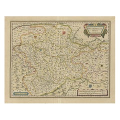
Duchy of Brunswick-Lüneburg, 1595: A Renaissance Cartographic Masterpiece
About the Item
Title: "Braunschweig and Lüneburg Duchies: Authentic Depiction by Abraham Ortelius"
This is an exquisite example of Abraham Ortelius’s cartographic craftsmanship: an original antique copper engraving depicting the Duchies of Braunschweig (Brunswick) and Lüneburg. Dated to 1595 and published in Antwerp, this map is hand-colored in outline, capturing the geographical nuances of the region during the Renaissance.
Stretching northward to the Elbe River and encompassing the notable city of Hamburg, the map is meticulously annotated with place names, including villages, rivers, woodlands, and other significant topographical features. Each engraved name and icon is a testament to the thorough surveying methods of the era and Ortelius's attention to detail.
A notable feature of this piece is the Renaissance title cartouche in the upper right corner, which is both an ornamental and a symbolic representation of the period's aesthetic. In the lower right, a mileage scale rendered in the map's color palette serves a practical purpose, guiding the measurements of distance with historical accuracy.
The reverse side of the map holds Latin text, offering additional context and scholarly content to this cartographic masterpiece. As a work of Abraham Ortelius, a renowned figure in the development of early modern cartography, this map holds significant value for collectors, historians, and enthusiasts of geographical history. It is a splendid reflection of the era's cartographic elegance and an enduring piece of Renaissance artistry.
Abraham Ortelius (1527–1598) was a notable figure in the history of cartography, credited with creating the first modern atlas. He was a Flemish cartographer and geographer, recognized as the 'father of modern geography' by many historians.
Here are some key points about his life and work:
1. **Early Life and Career**: Ortelius was born in Antwerp, which was part of the Habsburg Netherlands during a period known as the Dutch Golden Age. He began his career as a map engraver and dealer. He traveled extensively across Europe, gathering geographical information and establishing connections with other scholars.
2. **Theatrum Orbis Terrarum**: Ortelius's most famous contribution to cartography was the "Theatrum Orbis Terrarum" (Theatre of the World), first published in 1570. This is considered the first true modern atlas in that it was a systematically collected and standardized set of maps, all of similar size, and bound together into a book.
3. **Cartographic Advances**: Ortelius is known for hypothesizing that the continents were once joined together before drifting apart, a notion that would much later be developed into the theory of continental drift. His work often included maps from other cartographers, which he compiled and sometimes improved upon based on the latest geographical knowledge.
4. **Impact and Legacy**: The "Theatrum Orbis Terrarum" went through numerous editions and was published in several languages, reflecting its wide-reaching impact. Ortelius was appointed as the Royal Geographer to King Philip II of Spain, a position that reflected the respect he commanded in his field.
5. **Collaborations**: Ortelius also maintained a network of correspondents across Europe, including prominent figures such as Gerardus Mercator. This network was crucial for the exchange of cartographic knowledge and discoveries.
6. **Death and Commemoration**: After his death, Ortelius was hailed for his contributions to geography and cartography. His work was carried on by others, including his nephew, who continued to publish editions of the "Theatrum."
Ortelius's work not only marked a significant advancement in map-making but also reflected the broader cultural and scientific developments of the Renaissance. His atlas helped lay the foundation for the way we think about maps and geography today.
- Dimensions:Height: 16.93 in (43 cm)Width: 11.03 in (28 cm)Depth: 0 in (0.02 mm)
- Materials and Techniques:Paper,Engraved
- Period:
- Date of Manufacture:1595
- Condition:Repaired: A tear in the top is professionally closed and the right border has been strengthened. Good. Soiling and offset and scattered minor browning. A larger dirt spot in the top edge, far outside the image. Study the images carefully.
- Seller Location:Langweer, NL
- Reference Number:
About the Seller
5.0
Platinum Seller
These expertly vetted sellers are 1stDibs' most experienced sellers and are rated highest by our customers.
Established in 2009
1stDibs seller since 2017
1,919 sales on 1stDibs
Typical response time: <1 hour
- ShippingRetrieving quote...Ships From: Langweer, Netherlands
- Return PolicyA return for this item may be initiated within 14 days of delivery.
More From This SellerView All
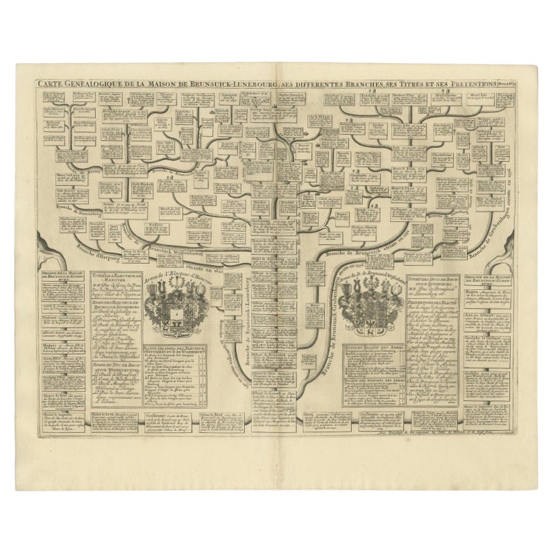
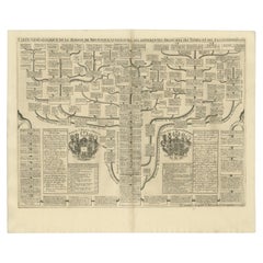
- Antique Genealogy Chart of the Duchy of Brunswick-Luneburg, Germany, 1732Located in Langweer, NLAntique print titled 'Carte Genealogique de la Maison de Brunsuick-Lunebourg'. Genealogy of the Duchy of Brunswick-Luneburg. With coats of arms of the Elector of Hannover and the Duc...Category
Antique 18th Century Prints
MaterialsPaper
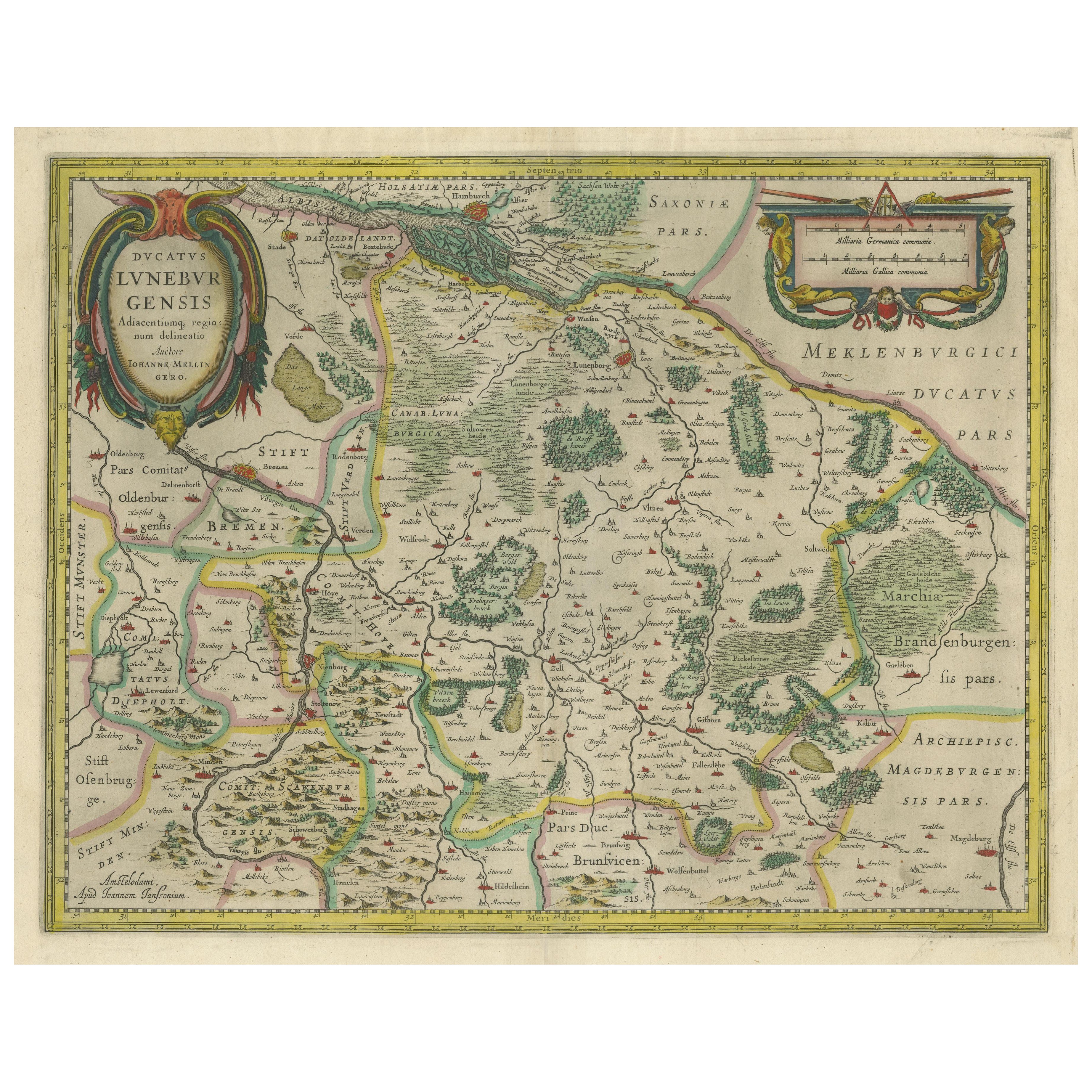
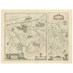
- Antique Map of the Duchy of Lüneburg, Lower Saxony, GermanyLocated in Langweer, NLAntique map titled 'Ducatus Luneburgensis (..)'. Map of the Duchy of Lüneburg in Lower Saxony, Germany. Published by J. Janssonius, circa 1664. Jan Janssonius (also known as Johann ...Category
Antique Mid-17th Century Maps
MaterialsPaper
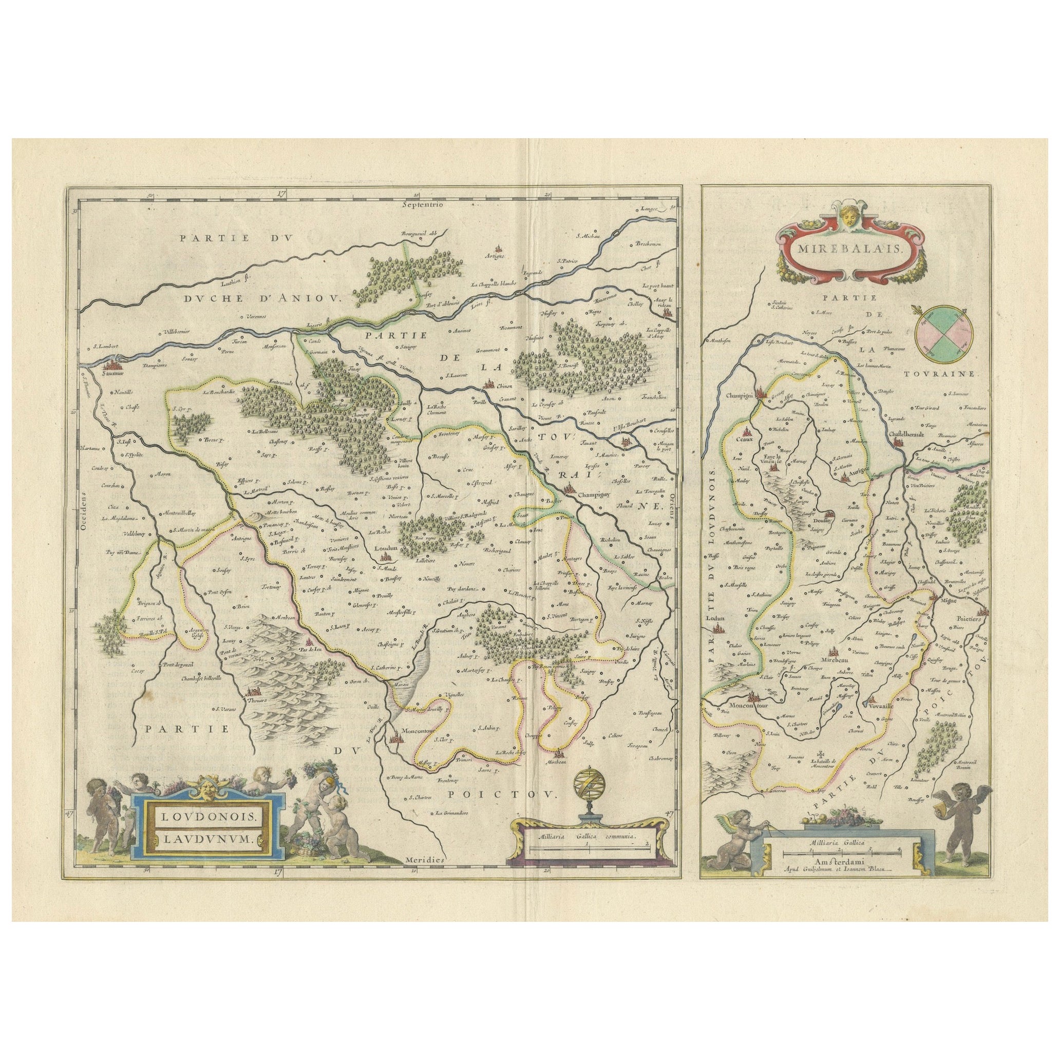
- Loudun and Mirebeau: A Cartographic Masterpiece of 17th Century France by BlaeuLocated in Langweer, NLCartography, 17th century. Willem (1571-1638) and Joan Blaeu (1596-1673), Theatrum Orbis Terrarum sive Atlas Novus..., 1635. Figure: Loudonois. Laudunum (Loudun); Mirebalais (Mirebea...Category
Antique 1650s Maps
MaterialsPaper
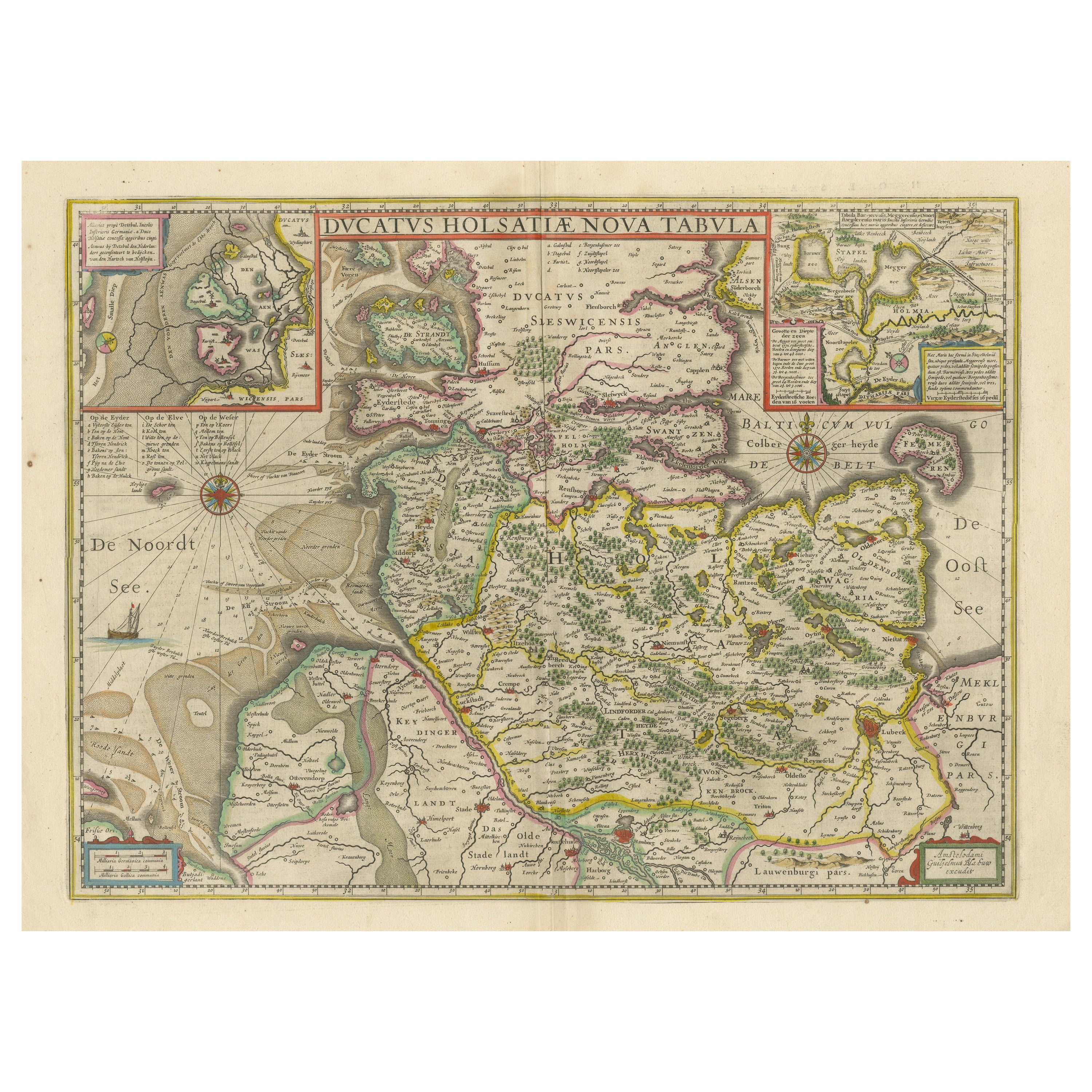
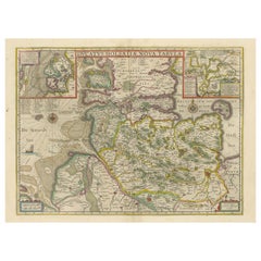
- Original Antique Map of the Duchy of HolsteinBy Willem BlaeuLocated in Langweer, NLAntique map titled 'Ducatus Holsatiae Nova Tabula'. Original old map of the Duchy of Holstein, the northernmost territory of the Holy Roman Empire, from the mid-17th Century. To the ...Category
Antique Mid-17th Century Maps
MaterialsPaper
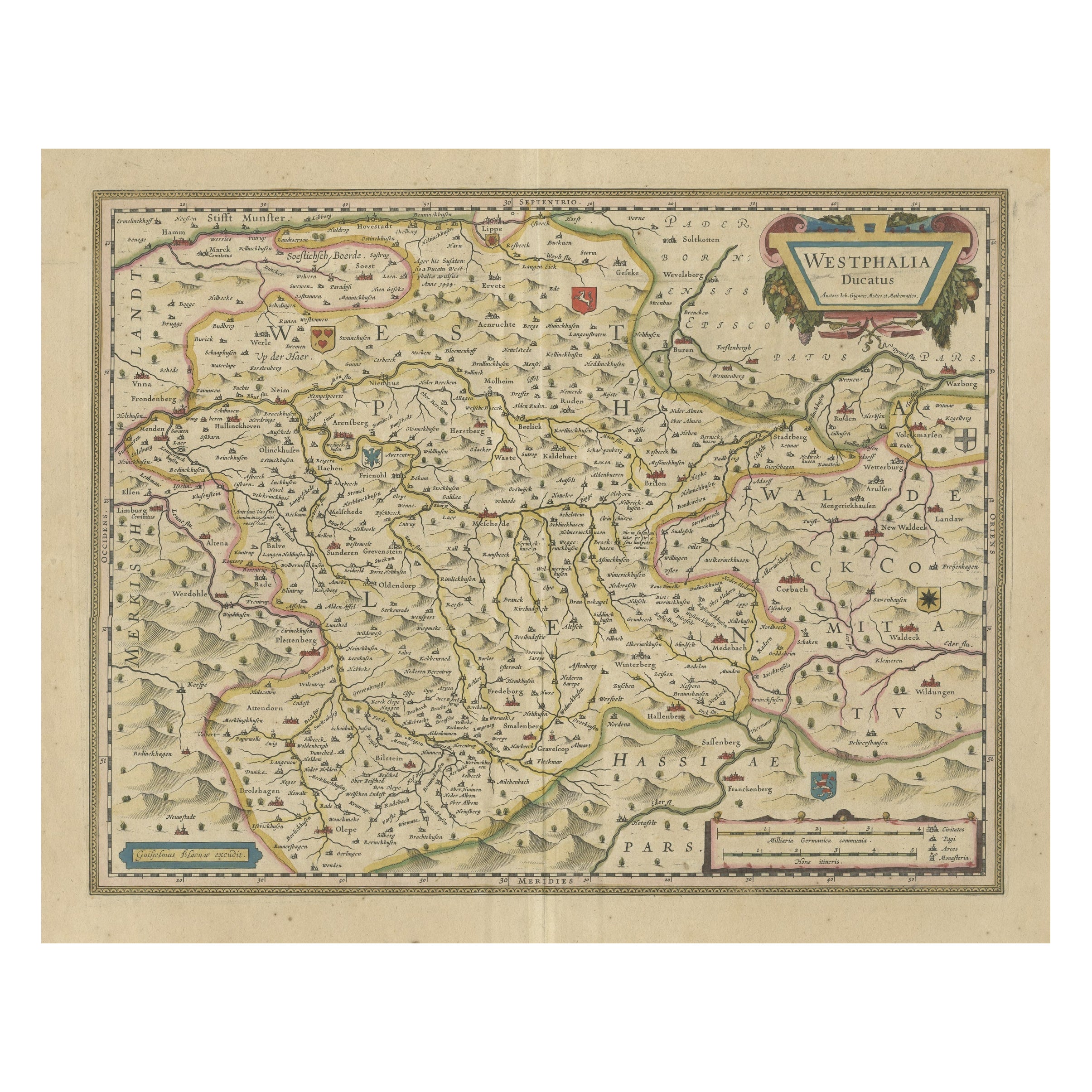
- Antique Map of the Duchy of Westphalia, GermanyLocated in Langweer, NLOriginal antique map titled 'Westphalia Ducatus'. Fine map of the Duchy of Westphalia, Germany. The map is centered on Meschede and includes Arensberg, Beelick, and Brilon. Published...Category
Antique Mid-17th Century Maps
MaterialsPaper
- Antique Map of East Frisia by Ortelius, c.1595Located in Langweer, NLAntique print, titled: 'Frisia Orientalis.' Map of East Frisia originating from 'Theatrum Orbis Terrarum'. It is based on the manuscript map by Jon Bloe...Category
Antique 16th Century Maps
MaterialsPaper


You May Also Like
- "The Masterpieces of Engraving"By Eugene Maxime ValléeLocated in Alessandria, PiemonteO/7821 - interesting French book that I saved from ruin: they are usually dismembered to make prints to sell individually. This one is intact, with its 24 printed plates. Nice to ...Category
Antique Mid-19th Century French Other Books
MaterialsPaper
- Masterpieces of Modern ArchitectureLocated in Bradenton, FLMasterpieces of Modern Architecture. Published by Barnes & Noble of New York in 2006. Hardcover book with dustjacket. 303 pages.Category
21st Century and Contemporary Books
MaterialsPaper
- Antique Lithography Map of Cheshire, English, Framed, Cartography, VictorianLocated in Hele, Devon, GBThis is an antique lithography map of Cheshire. An English, framed atlas engraving of cartographic interest, dating to the mid 19th century and lat...Category
Antique Mid-19th Century British Victorian Maps
MaterialsWood
- Sun and Moon a Story of Astronomy, Photography and CartographyLocated in New York City, NYA unique pictorial history of astronomical exploration from the earliest Prehistoric observatories to the latest satellite images with 280 spectacular images and an inspiring story i...Category
21st Century and Contemporary European Books
MaterialsPaper
- Vincent Van Gogh Masterpieces of ArtBy Vincent van GoghLocated in North Hollywood, CAVincent Van Gogh Masterpieces of Art by Stephanie Cotela Tanner. Hardcover Art Book Page count:128 Published:June 12, 2014 Contributor:Susie Hodge Format:Hardcover Publisher:Flame Tree Publishing Language:English Author:Stephanie Cotela Tanner Part of a new series of beautiful gift art books, Van Gogh Masterpieces of Art features all of the best-known works of one of the most famous artists in the world, preceded by a fresh and thoughtful introduction providing lively commentary on his life, society, places and style and techniques, including the powerful animation of his strident brushwork. "He did not paint his pictures; it was like he exhaled them in a gasping, boiling breath," one German critic aptly wrote of Van Gogh. Reminiscences of the artist by friends and passing acquaintances, letters from his brother Theo and appreciations by critics and artists make up the text of this handsomely packaged potpourri. For Margritte, the blind force of Van Gogh's obsessions made the tortured artist an unfree man. To Kokoschka, the tension in the painter's famous sunflowers and undulating cypresses speak of the fragility of an easygoing lifestyle in a mechanized age. Each artist seems to confront his or her own concerns when analyzing Van Gogh. Jean Renoir, Francoise Gilot, Gauguin and Klee are among the commentators. One hundred twenty-five superior color reproductions and 103 halftones remind us that Van Gogh could do a very formal Still Life with Coffeepot, a street scene ablaze with fauve-like color or the solemn, biblical Raising of Lazarus...Category
21st Century and Contemporary Dutch Expressionist Books
MaterialsPaper
- Antique Lithography Map, Isle of Wight, English, Framed, Engraving, CartographyLocated in Hele, Devon, GBThis is an antique lithography map of the Isle of Wight. An English, framed atlas engraving of cartographic interest, dating to the early 19th century and later. Superb lithography ...Category
Antique Early 19th Century British Regency Maps
MaterialsWood


Recently Viewed
View AllMore Ways To Browse
La Syrie Antique
Laos Antique Map
Moravia Map
Nova Totius
Antique Indiana Map
Antique Map Delaware
Antique Maps Rhode Island
Antique Map Of North And East Asia 1751
Republic Of Texas Map
Vintage Road Maps Collectables
Astrological Map
Astrology Map
Atlas Indu
English County Maps By Blaeu
Kiels Antiques
Mauritius Antique Map
Old Cypriot Maps
Tanzania Antique Map