Items Similar to Antique Map of the Routes of Jean-françois de Galaup to Asia, 1787

Want more images or videos?
Request additional images or videos from the seller
1 of 5
Antique Map of the Routes of Jean-françois de Galaup to Asia, 1787
$325.69
$407.1120% Off
£240.76
£300.9520% Off
€272
€34020% Off
CA$442.96
CA$553.7020% Off
A$496.34
A$620.4220% Off
CHF 258.36
CHF 322.9520% Off
MX$6,071.93
MX$7,589.9220% Off
NOK 3,279.44
NOK 4,099.3020% Off
SEK 3,097.39
SEK 3,871.7420% Off
DKK 2,071.15
DKK 2,588.9320% Off
Shipping
Retrieving quote...The 1stDibs Promise:
Authenticity Guarantee,
Money-Back Guarantee,
24-Hour Cancellation
About the Item
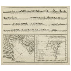
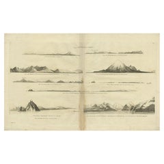
Antique map titled 'Suite de la Route des Vaisseaux Francois'. Antique map of the routes of Jean-François de Galaup to Asia (Jakarta, Indonesia). This map originates from 'World atlas for the study of geography and ancient and modern history', Paris 1787, showing the route along the north coast of Java.
Artists and Engravers: Etienne Andre Philippe de Pretot (1708-1787), French cartographer.
Condition: Good, general age-related toning. Minor fading, please study image carefully.
Date: 1787
Overall size: 45 x 29 cm.
Image size: 26 x 17 cm.
We sell original antique maps to collectors, historians, educators and interior decorators all over the world. Our collection includes a wide range of authentic antique maps from the 16th to the 20th centuries. Buying and collecting antique maps is a tradition that goes back hundreds of years. Antique maps have proved a richly rewarding investment over the past decade, thanks to a growing appreciation of their unique historical appeal. Today the decorative qualities of antique maps are widely recognized by interior designers who appreciate their beauty and design flexibility. Depending on the individual map, presentation, and context, a rare or antique map can be modern, traditional, abstract, figurative, serious or whimsical. We offer a wide range of authentic antique maps for any budget.
- Dimensions:Height: 11.42 in (29 cm)Width: 17.72 in (45 cm)Depth: 0 in (0.01 mm)
- Materials and Techniques:
- Period:
- Date of Manufacture:1787
- Condition:Condition: Good, general age-related toning. Minor fading, please study image carefully.
- Seller Location:Langweer, NL
- Reference Number:Seller: BG-079431stDibs: LU3054327912872
About the Seller
5.0
Recognized Seller
These prestigious sellers are industry leaders and represent the highest echelon for item quality and design.
Platinum Seller
Premium sellers with a 4.7+ rating and 24-hour response times
Established in 2009
1stDibs seller since 2017
2,494 sales on 1stDibs
Typical response time: 1 hour
- ShippingRetrieving quote...Shipping from: Langweer, Netherlands
- Return Policy
Authenticity Guarantee
In the unlikely event there’s an issue with an item’s authenticity, contact us within 1 year for a full refund. DetailsMoney-Back Guarantee
If your item is not as described, is damaged in transit, or does not arrive, contact us within 7 days for a full refund. Details24-Hour Cancellation
You have a 24-hour grace period in which to reconsider your purchase, with no questions asked.Vetted Professional Sellers
Our world-class sellers must adhere to strict standards for service and quality, maintaining the integrity of our listings.Price-Match Guarantee
If you find that a seller listed the same item for a lower price elsewhere, we’ll match it.Trusted Global Delivery
Our best-in-class carrier network provides specialized shipping options worldwide, including custom delivery.More From This Seller
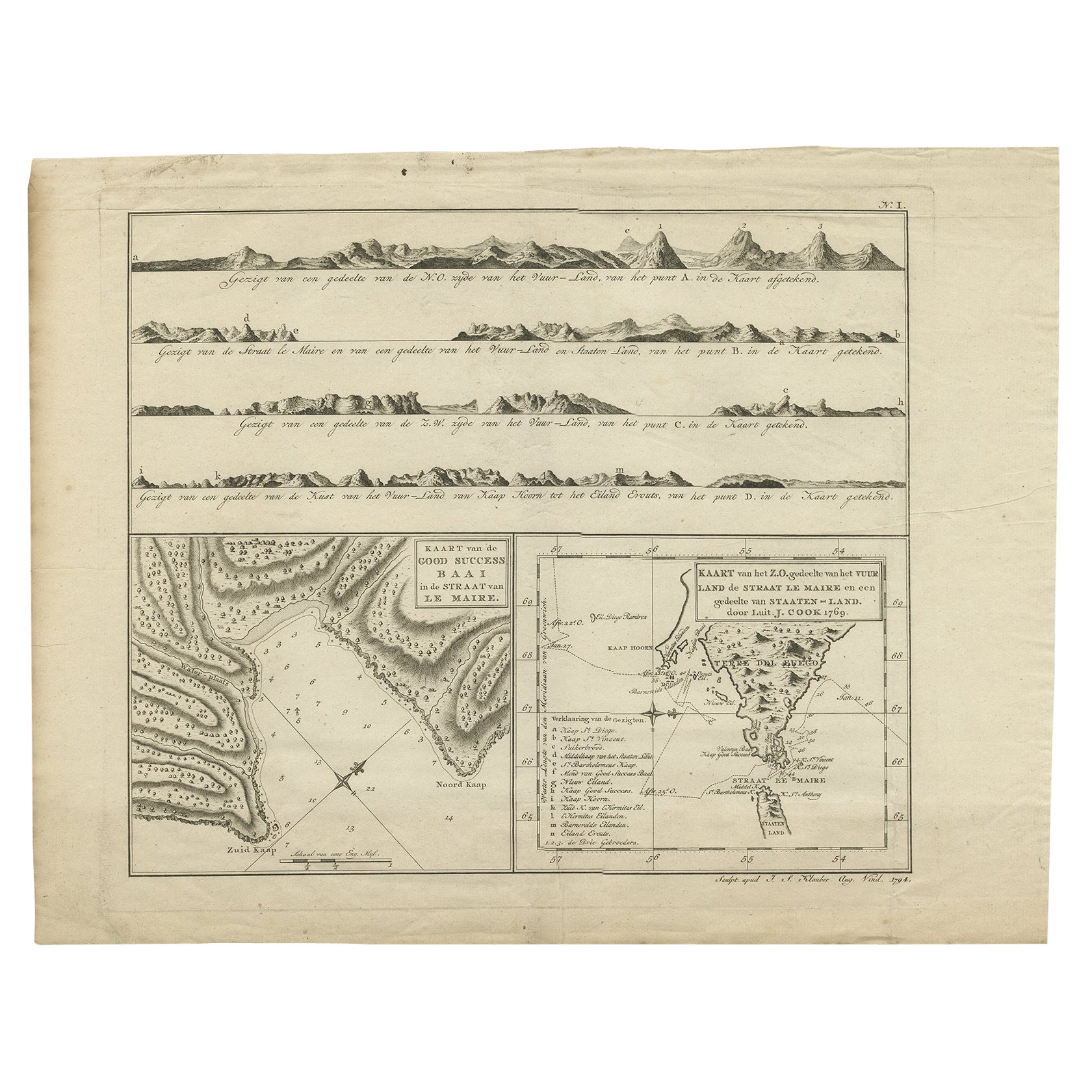
View AllAntique Map of the Strait of Le Maire by Cook, 1803
Located in Langweer, NL
Antique map titled 'Kaart van de Good Success Baai in de Straat van Le Maire (..)'. Antique map of the Strait of Le Maire between Terra Fuego and Staten Island. On top, various coast...
Category
Antique 19th Century Maps
Materials
Paper

$603 Sale Price
20% Off
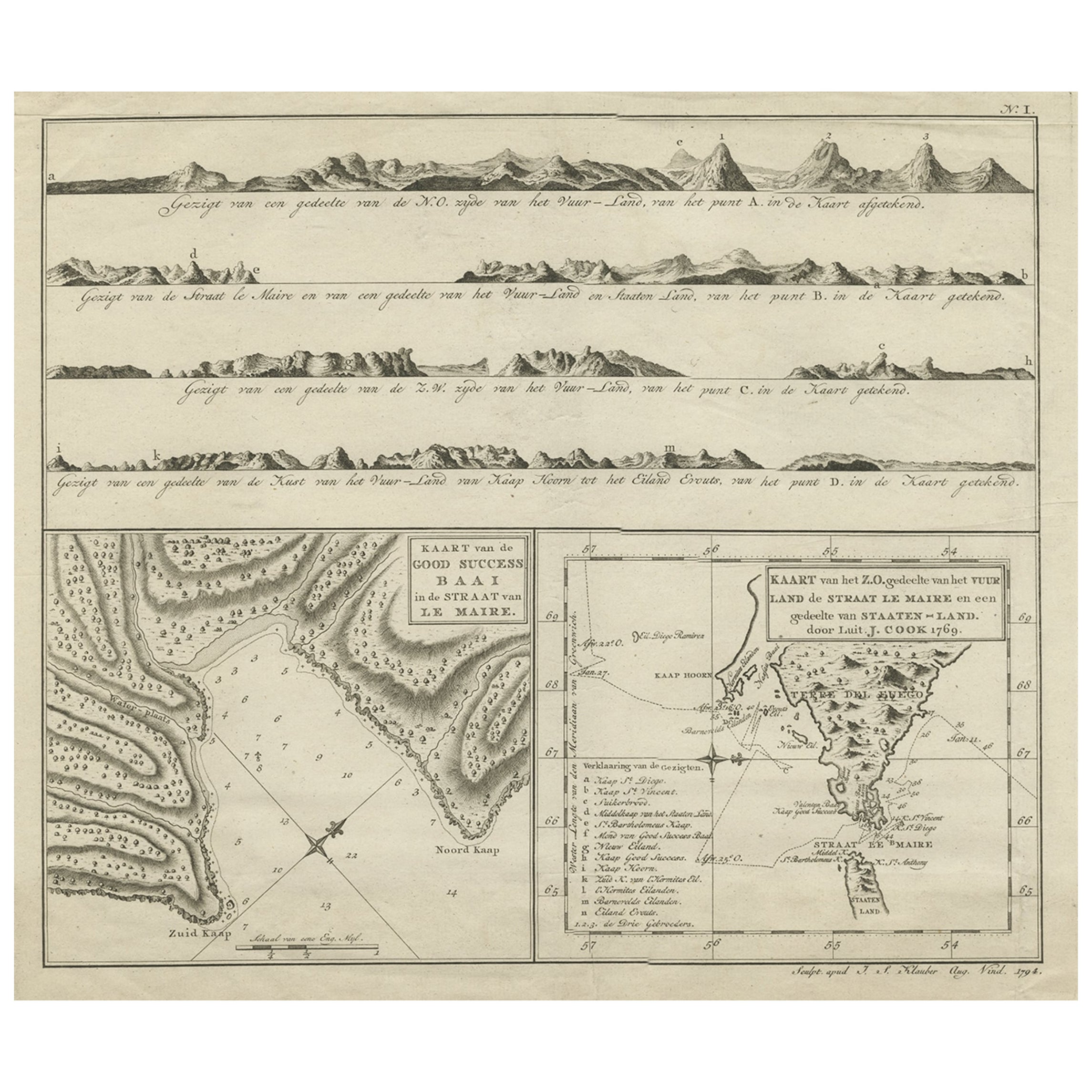
Antique Map of the Strait of Le Maire Between Terra Fuego & Staten Island, 1803
Located in Langweer, NL
Antique map titled 'Kaart van de Good Success Baai in de Straat van Le Maire (..)'.
Antique map of the Strait of Le Maire between Terra Fuego and Staten Island. On top, various c...
Category
Antique Early 1800s Maps
Materials
Paper
$603 Sale Price
20% Off
Antique Map of Port Pallisers & Kersmis by Cook, c.1781
Located in Langweer, NL
Antique map Kerguelen titled 'Sketch of Port Palliser on Kerguelen's Land (..)'. Antique map of Port Pallisers & Kersmis, Kerguelen or Desolation Islands. Originates from an edition ...
Category
Antique 18th Century Maps
Materials
Paper

$220 Sale Price
20% Off
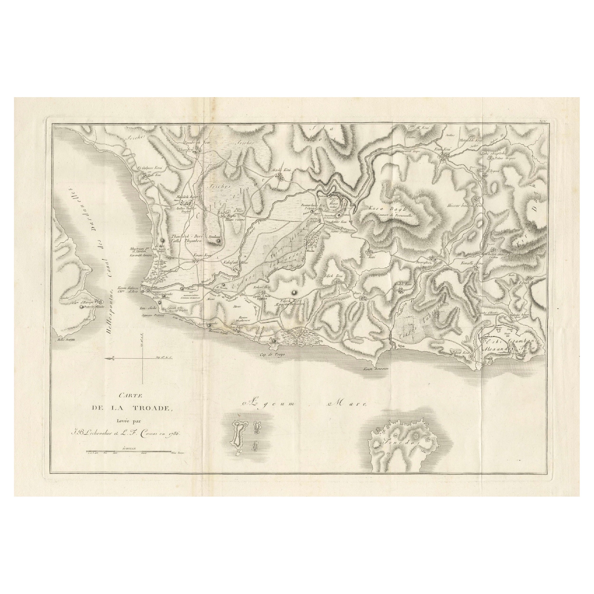
Circa 1802 Map of the Troad Region by Tardieu – From the Voyage de la Troade
Located in Langweer, NL
This is a large fold-out map titled *Carte de la Troade*, measuring approximately 53.5 x 68 cm, engraved by Tardieu, and extracted from the atlas of *Voyage de la Troade, fait dans l...
Category
Antique Early 1800s Maps
Materials
Paper
$239 Sale Price
20% Off
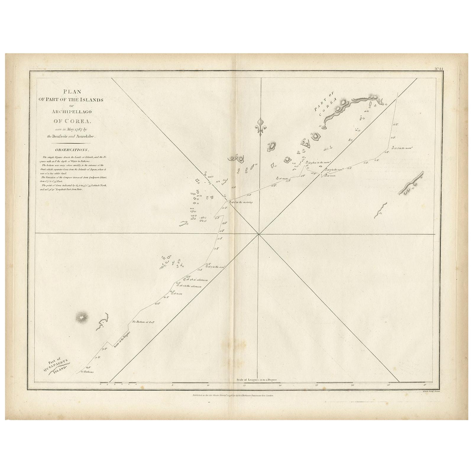
Antique Map of Part of the Korean Archipelago, 1798
Located in Langweer, NL
Antique map titled 'Plan of Part of the Islands or Archipellago of Corea'. This map depicts part of the Korean Archipelago and originates from Charts and Plates to La Pérouse...
Category
Antique Late 18th Century Maps
Materials
Paper
$526 Sale Price
20% Off
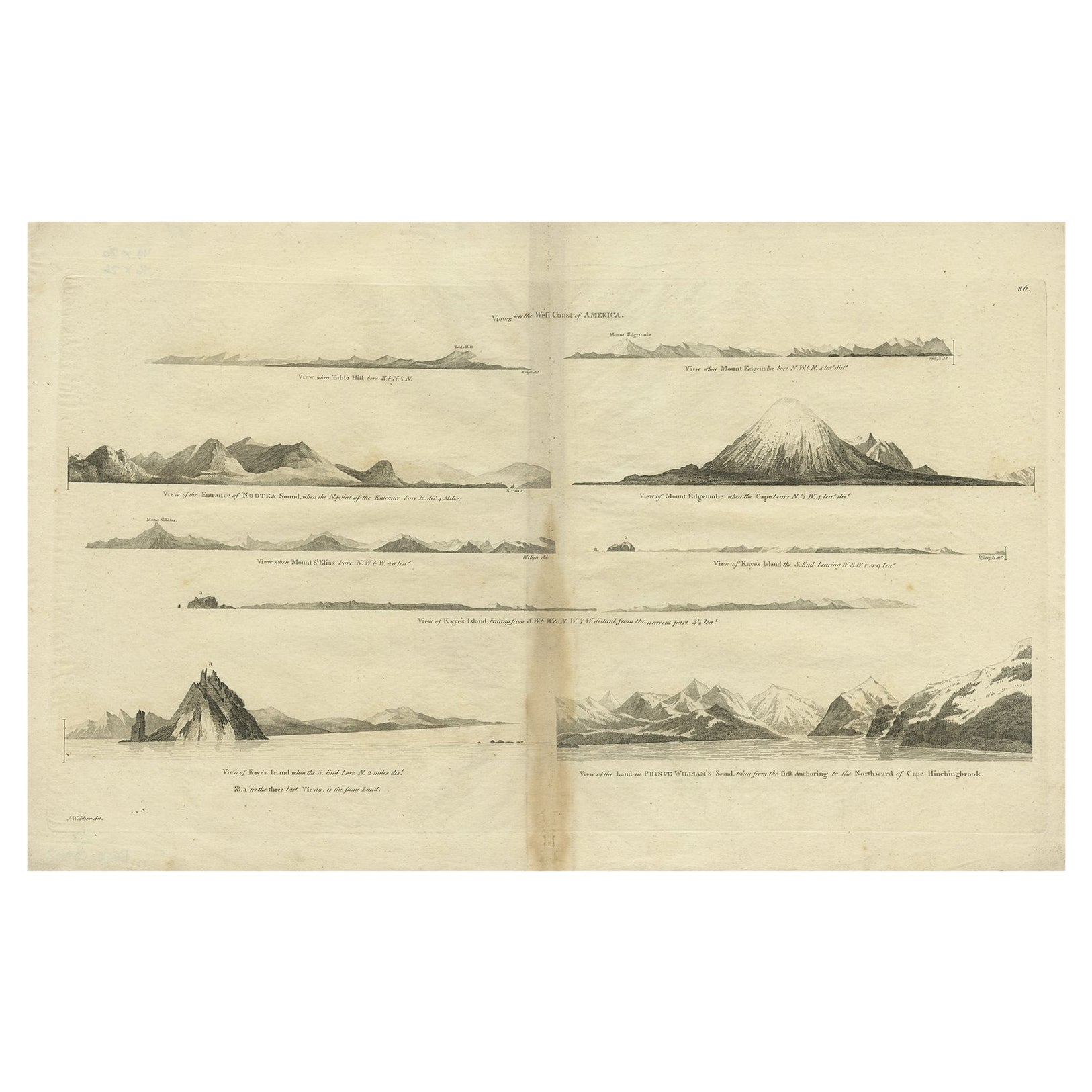
Antique Map of the West Coast of America with Island Views, ca.1784
Located in Langweer, NL
Antique print titled 'Views on the West Coast of America (..)'.
Coastal views of various islands of the American coast. Originates from an edition of Cook's Voyages.
Artists ...
Category
Antique 1780s Maps
Materials
Paper
$431 Sale Price
20% Off
You May Also Like
Antique French Map of Asia Including China Indoneseia India, 1783
Located in Amsterdam, Noord Holland
Very nice map of Asia. 1783 Dedie au Roy.
Additional information:
Country of Manufacturing: Europe
Period: 18th century Qing (1661 - 1912)
Condition: Overall Condition B (Good Used)...
Category
Antique 18th Century European Maps
Materials
Paper

$648 Sale Price
20% Off
West Coast of Africa, Guinea & Sierra Leone: An 18th Century Map by Bellin
By Jacques-Nicolas Bellin
Located in Alamo, CA
Jacques Bellin's copper-plate map entitled "Partie de la Coste de Guinee Dupuis la Riviere de Sierra Leona Jusquau Cap das Palmas", depicting the coast of Guinea and Sierra Leone in ...
Category
Antique Mid-18th Century French Maps
Materials
Paper

1814 Map of "Russian Empire" Ric.r032
Located in Norton, MA
1814 Map of
"Russian Empire"
Ric.r032
Russian Empire. Description: This is an 1814 John Thomson map of the Russian Empire. The map depicts the region from the Baltic Sea, Prussia, and Sweden to the Aleutian Islands and from the Arctic Ocean to the Yellow River. Highly detailed, myriad cities, towns, and villages are labeled throughout, including St. Petersburg, Moscow, Minsk, Kiev, and Kharkov. Rivers and mountain ranges are also identified, as are islands and numerous locations along the coastlines. It is important to note that the long-disputed sea between Korea and Japan is identified as the 'Sea of Japan.
Historical Context:
In 1815, Tsarist Russia emerged from the Napoleonic Wars economically insolvent and politically fearful of the Revolutionary fervor that had just swept through Europe. In order to shore up Russia's economic position, the Tsars began an aggressive series of expansions into the Caucuses and Central Asia that would vastly increase the landmass of the Russian Empire.
Publication History
Thomson maps are known for their stunning color, awe inspiring size, and magnificent detail. Thomson's work, including this map, represents some of the finest cartographic art...
Category
Antique 19th Century Unknown Maps
Materials
Paper

Antique 1803 Italian Map of Asia Including China Indoneseia India
Located in Amsterdam, Noord Holland
Antique 1803 Italian Map of Asia Including China Indoneseia India
Very nice map of Asia. 1803.
Additional information:
Type: Map
Country of Manufacturing: Europe
Period: 19th centu...
Category
Antique 19th Century European Maps
Materials
Paper

$584 Sale Price
20% Off
California, Alaska and Mexico: 18th Century Hand-Colored Map by de Vaugondy
By Didier Robert de Vaugondy
Located in Alamo, CA
This is an 18th century hand-colored map of the western portions of North America entitled "Carte de la Californie et des Pays Nord-Ouest separés de l'Asie par le détroit d'Anian, ex...
Category
Antique 1770s French Maps
Materials
Paper

Super Rare Antique French Map of Chine and the Chinese Empire, 1780
Located in Amsterdam, Noord Holland
Super Rare Antique French Map of Chine and the Chinese Empire, 1780
Very nice map of Asia. 1780 Made by Bonne.
Additional information:
Type: Map
...
Category
Antique 18th Century European Maps
Materials
Paper

$584 Sale Price
33% Off
More Ways To Browse
Antique Map Of Colombia
Antique Map Palestine
Vintage Wooden Roller
Antique Constellation Map
Antique Maps Of Cape Of Good Hope
Caucasus Map
Map Of Puerto Rico
Nevada Antique Map
Shetland Map
Antique Chicago Maps
Kolkata Antique Furniture
Antique Bermuda Furniture
Antique Dairy Collectibles
Antique Map Of Cuba
Antique Map Of Yorkshire
Antique Map Vietnam
Antique Maps Massachusetts
Guyana Antique Map