Items Similar to Antique Map of Southeastern France by Vaugondy, c.1790

Want more images or videos?
Request additional images or videos from the seller
1 of 5
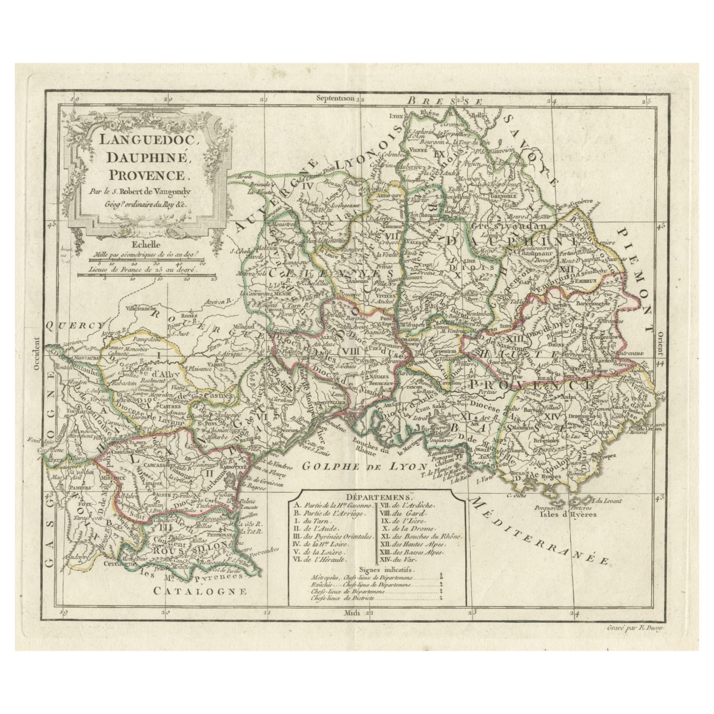
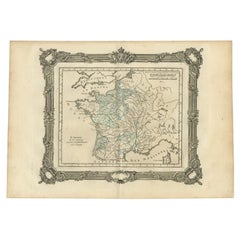
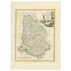
Antique Map of Southeastern France by Vaugondy, c.1790
$153.49
$191.8720% Off
£114.18
£142.7320% Off
€128
€16020% Off
CA$210.19
CA$262.7320% Off
A$233.70
A$292.1220% Off
CHF 122.02
CHF 152.5320% Off
MX$2,844.69
MX$3,555.8620% Off
NOK 1,556.98
NOK 1,946.2320% Off
SEK 1,458.82
SEK 1,823.5320% Off
DKK 974.39
DKK 1,217.9920% Off
Shipping
Retrieving quote...The 1stDibs Promise:
Authenticity Guarantee,
Money-Back Guarantee,
24-Hour Cancellation
About the Item
"Antique map titled 'Languedoc, Dauphiné, Province'. Beautiful antique map of Southeastern France with decorative cartouche. Map includes topographical detail as well as a reference to the departments at the time of publication. Artists and Engravers: Gilles Robert de Vaugondy (1688-1766), also known as Le Sieur or Monsieur Robert, and his son, Didier Robert de Vaugondy (c.1723-1786), were leading cartographers in France during the 18th century.
Artist: Gilles Robert de Vaugondy (1688-1766), also known as Le Sieur or Monsieur Robert, and his son, Didier Robert de Vaugondy (c.1723-1786), were leading cartographers in France during the 18th century.
Condition: Very good, contemporary hand coloring. Please study image carefully.
Date: c.1790
Overall size: 41.5 x 29 cm.
Image size: 0.001 x 29 x 24 cm.
Antique prints have long been appreciated for both their aesthetic and investment value. They were the product of engraved, etched or lithographed plates. These plates were handmade out of wood or metal, which required an incredible level of skill, patience and craftsmanship. Whether you have a house with Victorian furniture or more contemporary decor an old engraving can enhance your living space. We offer a wide range of authentic antique prints for any budget.".
- Dimensions:Height: 11.42 in (29 cm)Width: 16.34 in (41.5 cm)Depth: 0 in (0.01 mm)
- Materials and Techniques:
- Period:
- Date of Manufacture:circa 1790
- Condition:
- Seller Location:Langweer, NL
- Reference Number:Seller: BG-005171stDibs: LU3054327659902
About the Seller
5.0
Recognized Seller
These prestigious sellers are industry leaders and represent the highest echelon for item quality and design.
Platinum Seller
Premium sellers with a 4.7+ rating and 24-hour response times
Established in 2009
1stDibs seller since 2017
2,510 sales on 1stDibs
Typical response time: <1 hour
- ShippingRetrieving quote...Shipping from: Langweer, Netherlands
- Return Policy
Authenticity Guarantee
In the unlikely event there’s an issue with an item’s authenticity, contact us within 1 year for a full refund. DetailsMoney-Back Guarantee
If your item is not as described, is damaged in transit, or does not arrive, contact us within 7 days for a full refund. Details24-Hour Cancellation
You have a 24-hour grace period in which to reconsider your purchase, with no questions asked.Vetted Professional Sellers
Our world-class sellers must adhere to strict standards for service and quality, maintaining the integrity of our listings.Price-Match Guarantee
If you find that a seller listed the same item for a lower price elsewhere, we’ll match it.Trusted Global Delivery
Our best-in-class carrier network provides specialized shipping options worldwide, including custom delivery.More From This Seller
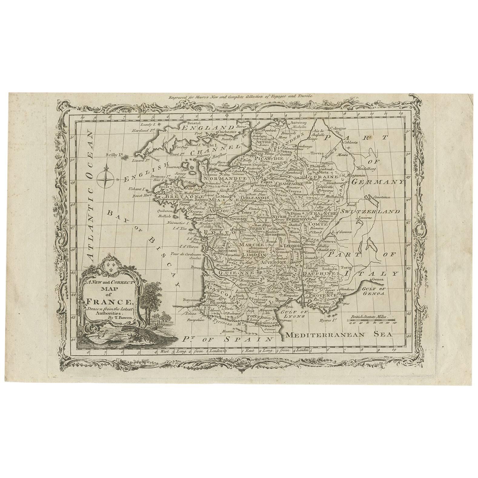
View AllAntique Map of France by T. Bowen, 1785
Located in Langweer, NL
Decorative antique map of France titled 'A new and accurate map of France, Drawn from the latest Authorities by T. Bowen'. Engraved for Moore’s new and complete collection of Voyages...
Category
Antique Late 18th Century Maps
Materials
Paper
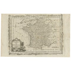
$153 Sale Price
20% Off
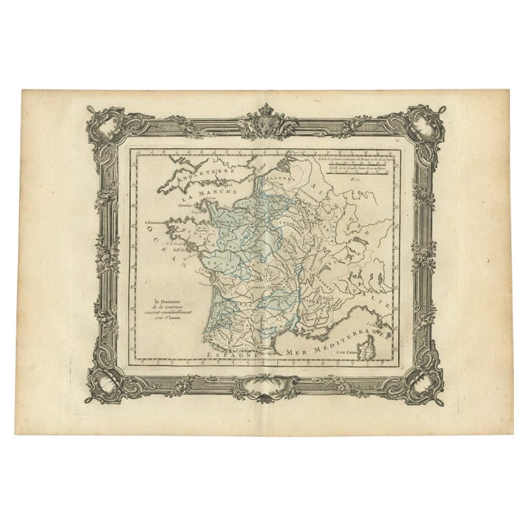
Antique Map of France under the Reign of St. Louis by Zannoni, 1765
Located in Langweer, NL
Antique map France titled 'Le Domaine de la Couronne (..)'. Beautiful old map of France. This map originates from 'Atlas Historique de la France Ancienne et Moderne' by M. Rizzi Zann...
Category
Antique 18th Century Maps
Materials
Paper
$143 Sale Price
20% Off
Beautiful Antique Map of Southeastern France with Decorative Cartouche, ca.1790
Located in Langweer, NL
Antique map titled 'Languedoc, Dauphiné, Province'.
Beautiful antique map of Southeastern France with decorative cartouche. Map includes topographical detail as well as a referen...
Category
Antique 1790s Maps
Materials
Paper
$364 Sale Price
20% Off
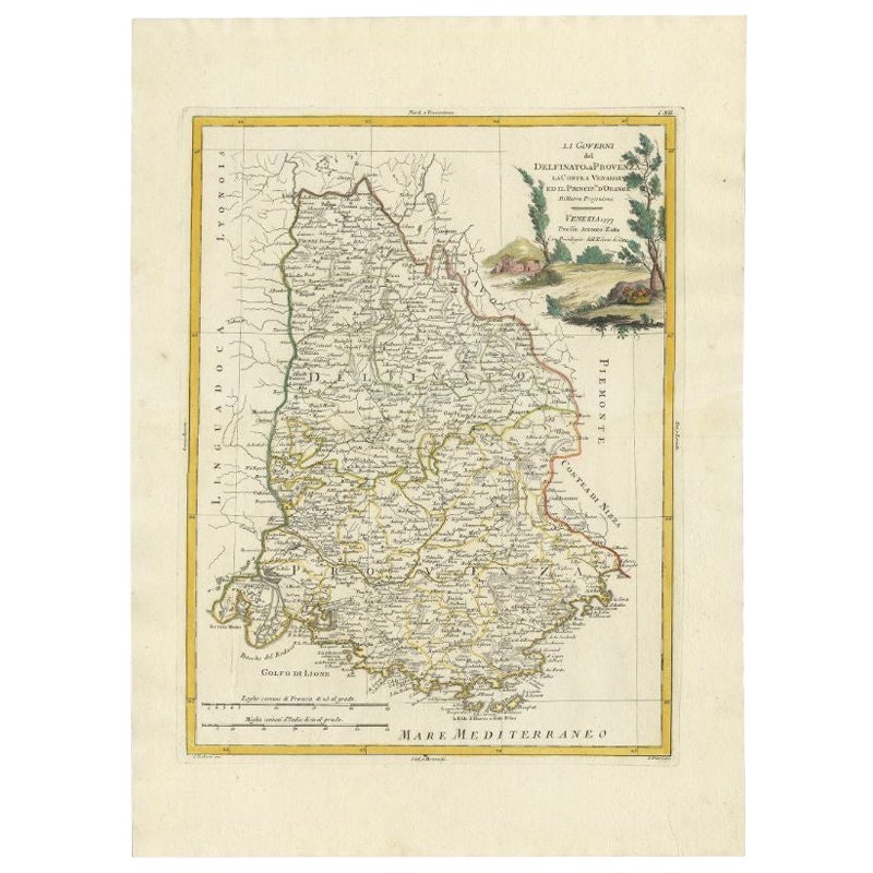
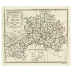
Antique Map of the Region of Dauphiné by Zatta, 1779
Located in Langweer, NL
Antique map titled 'Li Governi del Delfinato e di Provenza la Contea Venaissin ed il Princie d'Orange'. Old map of France showing the province of Dauphiné. This map originates from '...
Category
Antique 18th Century Maps
Materials
Paper
Antique Map of ancient France by Zannoni, 1765
Located in Langweer, NL
Antique map France titled 'Galliae Veteris (..)'. Beautiful old map of France. This map originates from 'Atlas Historique de la France Ancienne et Moderne' ...
Category
Antique 18th Century Maps
Materials
Paper

$306 Sale Price
20% Off
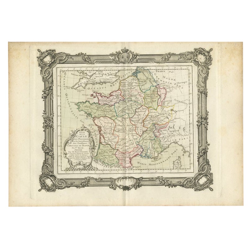
Antique Map of France in the 5th Century by Zannoni, 1765
Located in Langweer, NL
Antique map France titled 'Etat de la Gaule (..)'.
Beautiful old map of France. This map originates from 'Atlas Historique de la France Ancienne et Moderne' by M. Rizzi Zannoni. ...
Category
Antique 18th Century Maps
Materials
Paper
$152 Sale Price
20% Off
You May Also Like
1771 Bonne Map of Poitou, Touraine and Anjou, France, Ric.a015
Located in Norton, MA
1771 Bonne Map of Poitou,
Touraine and Anjou, France
Ric.a015
1771 Bonne map of Potiou, Touraine and Anjou entitled "Carte des Gouvernements D'Anjou et du Saumurois, de la Touraine, du Poitou,du Pays d'aunis, Saintonge?Angoumois,"
Carte des gouvernements d'Anjou et du Saumurois, de la Touraine, du Poitou, du Pays d'Aunis, Saintonge-Angoumois. Projettee et assujettie au ciel par M. Bonne, Hyd. du Roi. A Paris, Chez Lattre, rue St. Jacques a la Ville de Bord(ea)ux. Avec priv. du Roi. 1771. Arrivet inv. & sculp., Atlas moderne ou collection de cartes sur toutes...
Category
Antique 17th Century Unknown Maps
Materials
Paper

1752 Vaugoundy Map of Flanders : Belgium, France, and the Netherlands, Ric.a002
Located in Norton, MA
Large Vaugoundy Map of Flanders:
Belgium, France, and the Netherlands
Colored -1752
Ric.a002
Description: This is a 1752 Didier Robert de Vaugondy map of Flanders. The map de...
Category
Antique 17th Century Unknown Maps
Materials
Paper

Map of France - Etching - 1820
Located in Roma, IT
Map of France is an Original Etching realized by an unknown artist of 19th century in 1820.
Very good condition on two sheets of white paper joined at t...
Category
1820s Modern Figurative Prints
Materials
Etching

1751 Map of Spain Castilla Robert De Vaugondy 1st Edition, Ric.a001
Located in Norton, MA
Large Spain Castilla Robert De Vaugondy
1751 1st Edition
-Colored- Ric.a001
Coming from a family of cartographers, a descendant of the famous Nicolas Sanson and ordinary geographer of the king, Gilles Robert de Vaugondy makes himself known by his maps of the French provinces.
He published an Essay on the History of Geography (1755) from which he excluded the physical geography "too systematic". After a Small Atlas (1748), he draws a universal Atlas (1758), a portable Atlas (1762).
His Atlas of the revolutions of the globe remains unpublished. His warnings and prefaces, his book reviews reveal a Cartesian mind and solid knowledge.
Very early, he associates with his works his son Didier who publishes, since 1742, the methodical tables of Nicolas Sanson, two Globes, one terrestrial, the other celestial (1752).
He is credited with a map of Poland...
Category
Antique 18th Century Unknown Maps
Materials
Paper

Large 19th Century Map of France
Located in Pease pottage, West Sussex
Large 19th Century Map of France.
Remarkable condition, with a pleasing age worn patina.
Recently framed.
France Circa 1874.
Category
Antique Late 19th Century French Maps
Materials
Linen, Paper

1839 Map of Karte Des "Russischen Reiches in Europa Und Asien" Ric.R0013
Located in Norton, MA
1839 map of Karte Des
"Russischen Reiches in Europa and Asien"
Ric.r013
Map of the European and Asian parts of Russian Empire. Karte der Russischen Reiches in Europa und Asien...
Category
Antique 19th Century Unknown Maps
Materials
Paper

More Ways To Browse
Wood And Sons Plate
18th Century French Lithograph
Ipswich Antique Furniture
Maps Balkans
Missouri Map
Antique Maps Of Texas
Antique Maps Virginia
Antique Railroad Scale
Jamaican Antique
Hindeloopen Furniture
Romania Map
Stanford Antique Furniture
Sardinia Map
Victorian Staircase
Nantucket Map
Afghanistan Antique Map
Antique Map Of Hawaii
Antique Florida Map