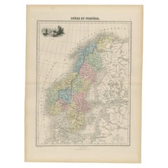
Items Similar to Antique Map of Sweden and Norway by Mitchell, 1846


Want more images or videos?
Request additional images or videos from the seller
1 of 5
Antique Map of Sweden and Norway by Mitchell, 1846
$114.65
$143.3220% Off
£86.47
£108.0920% Off
€98.40
€12320% Off
CA$158.52
CA$198.1520% Off
A$177.57
A$221.9620% Off
CHF 93.27
CHF 116.5820% Off
MX$2,159.19
MX$2,698.9920% Off
NOK 1,181.05
NOK 1,476.3120% Off
SEK 1,121.14
SEK 1,401.4220% Off
DKK 749.09
DKK 936.3620% Off
About the Item
Antique map titled 'Sweden & Norway'. Old map of Sweden and Norway. This map originates from 'A New Universal Atlas Containing Maps of the various Empires, Kingdoms, States and Republics Of The World (..) by S.A. Mitchell. Artists and Engravers: Samuel Augustus Mitchell was an American geographer. Mitchell worked as a teacher before turning to publishing geography textbooks and maps. He became involved in geography after teaching and realizing that there were so many poor quality geographical resources available to teachers. He was in Philadelphia when he founded his company. His son, S. Augustus Mitchell, became owner in 1860. Their publications covered all genres of geography: maps, travel guides, textbooks, and more.
Artist: Samuel Augustus Mitchell was an American geographer. Mitchell worked as a teacher before turning to publishing geography textbooks and maps. He became involved in geography after teaching and realizing that there were so many poor quality geographical resources available to teachers. He was in Philadelphia when he founded his company. His son, S. Augustus Mitchell, became owner in 1860. Their publications covered all genres of geography: maps, travel guides, textbooks, and more.
Condition: Good, original/contemporary hand coloring. Age-related toning and some wear, mainly in margins. Blank verso, please study image carefully.
Date: 1846
Overall size: 35 x 43.5 cm.
Image size: 0.001 x 24.5 x 30 cm.
Antique prints have long been appreciated for both their aesthetic and investment value. They were the product of engraved, etched or lithographed plates. These plates were handmade out of wood or metal, which required an incredible level of skill, patience and craftsmanship. Whether you have a house with Victorian furniture or more contemporary decor an old engraving can enhance your living space. We offer a wide range of authentic antique prints for any budget.
- Dimensions:Height: 17.13 in (43.5 cm)Width: 13.78 in (35 cm)Depth: 0 in (0.01 mm)
- Materials and Techniques:
- Period:
- Date of Manufacture:1846
- Condition:
- Seller Location:Langweer, NL
- Reference Number:Seller: BG-12418-311stDibs: LU3054327772332
About the Seller
5.0
Recognized Seller
These prestigious sellers are industry leaders and represent the highest echelon for item quality and design.
Platinum Seller
Premium sellers with a 4.7+ rating and 24-hour response times
Established in 2009
1stDibs seller since 2017
2,517 sales on 1stDibs
Typical response time: <1 hour
- ShippingRetrieving quote...Shipping from: Langweer, Netherlands
- Return Policy
Authenticity Guarantee
In the unlikely event there’s an issue with an item’s authenticity, contact us within 1 year for a full refund. DetailsMoney-Back Guarantee
If your item is not as described, is damaged in transit, or does not arrive, contact us within 7 days for a full refund. Details24-Hour Cancellation
You have a 24-hour grace period in which to reconsider your purchase, with no questions asked.Vetted Professional Sellers
Our world-class sellers must adhere to strict standards for service and quality, maintaining the integrity of our listings.Price-Match Guarantee
If you find that a seller listed the same item for a lower price elsewhere, we’ll match it.Trusted Global Delivery
Our best-in-class carrier network provides specialized shipping options worldwide, including custom delivery.More From This Seller
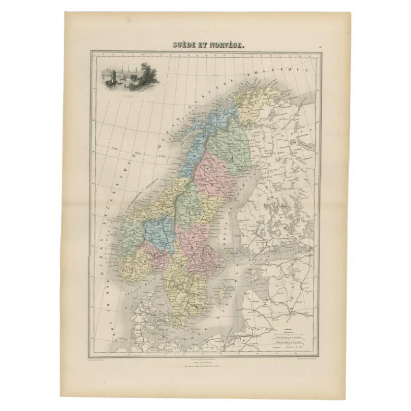
View AllAntique Map of Sweden and Norway by Migeon, 1880
Located in Langweer, NL
Antique map titled 'Suède et Norvége'. Old map of Sweden and Norway. With decorative vignette of Stockholm. This map originates from 'Géographie Universe...
Category
Antique 19th Century Maps
Materials
Paper
$102 Sale Price
20% Off
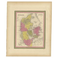
Antique Map of Scandinavia by Lapie, 1842
Located in Langweer, NL
Antique map titled 'Carte de la Scandinavie comprenant les Royaumes de Suède de Norwege et de Danemark'. Map of Scandinavia including Sweden, Norway and Denma...
Category
Antique Mid-19th Century Maps
Materials
Paper

$512 Sale Price
20% Off
Antique Map of Sweden and Norway by Petri, 1852
Located in Langweer, NL
Antique map titled 'Zweden en Noorwegen'. Map of Sweden and Norway. This map originates from 'School-Atlas van alle deelen der Aarde' by Otto Petri. Artists...
Category
Antique 19th Century Maps
Materials
Paper

$111 Sale Price
20% Off
Antique Map of Sweden and Norway by Petri, c.1873
Located in Langweer, NL
Antique map titled 'Zweden en Noorwegen'. Old map depicting Sweden and Norway. This map originates from 'School-Atlas van alle Deelen der Aarde'. Artists and Engravers: Published by ...
Category
Antique 19th Century Maps
Materials
Paper

$109 Sale Price
20% Off
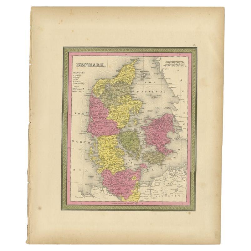
Antique Map of Denmark, Original and Decorative, c.1846
Located in Langweer, NL
Antique map titled 'Denmark'. Old map of Denmark. This map originates from 'A New Universal Atlas Containing Maps of the various Empires, Kingdoms, States and Republics Of The World ...
Category
Antique 19th Century Maps
Materials
Paper
$186 Sale Price
20% Off
Map of Scandinavia – Antique Atlas Map by A. Levasseur, France, 1875
Located in Langweer, NL
Map of Scandinavia – Antique Atlas Map by A. Levasseur, France, 1875
This elegant 19th-century map titled Carte des Royaumes de Suède, de Norvège et de Danem...
Category
Antique Late 19th Century French Maps
Materials
Paper

$378 Sale Price
35% Off
You May Also Like
Original Antique Map of Sweden, Engraved by Barlow, 1806
Located in St Annes, Lancashire
Great map of Sweden
Copper-plate engraving by Barlow
Published by Brightly & Kinnersly, Bungay, Suffolk. 1806
Unframed.
Category
Antique Early 1800s English Maps
Materials
Paper

Sweden & Adjacent Portions of Scandinavia: A Hand-Colored 18th C. Map by Homann
By Johann Baptist Homann
Located in Alamo, CA
This hand-colored map of Sweden and adjacent portions of Scandinavia entitled "Regni Sueciae in Omnes suas Subjacentes Provincias accurate divisi Tabula Generalis" was created by Joh...
Category
Antique 1720s German Maps
Materials
Paper

Large Original Vintage Map of Sweden and Norway circa 1920
Located in St Annes, Lancashire
Great map of Sweden and Norway
Original color. Good condition
Published by Alexander Gross
Unframed.
Category
Vintage 1920s English Victorian Maps
Materials
Paper

Ancient Map of Denmark and Sweden - Original Etching - 19th Century
By Giuseppe Malandrino
Located in Roma, IT
This Map of Denmark and Sweden is an etching realized by an anonymous artist.
The state of preservation of the artwork is good with some small diffused stains.
Sheet dimension: 27x...
Category
Late 19th Century Modern Figurative Prints
Materials
Etching

Scandinavia & Portions of Eastern Europe: 18th Century Hand-Colored Homann Map
By Johann Baptist Homann
Located in Alamo, CA
An early 18th century hand-colored copper-plate map entitled "Regni Sueciae in omnes suas Subjacentes Provincias accurate divisi Tabula Generalis" by Johann Baptist Homann (1663-1724...
Category
Antique Early 18th Century German Maps
Materials
Paper

1849 Map of "Europaische Russland", 'Meyer Map of European Russia', Ric. R017
Located in Norton, MA
1849 Map of
"Europaische Russland"
( Meyer Map of European Russia)
Ric.r017
A lovely map of European Russia dating to 1849 by Joseph Meyer. It covers the European portions of...
Category
Antique 19th Century Unknown Maps
Materials
Paper

More Ways To Browse
Wood And Sons Plate
Norway 19th Century
Norway Plate
Norwegian Decor
Sardinia Map
Victorian Staircase
Nantucket Map
Afghanistan Antique Map
Antique Map Of Hawaii
Antique Florida Map
Map Of Syria
Napoleon Map
South Arabian
Antique Geological Maps
French School Map
Nova Scotia Antique Furniture
Richard Wentworth
Antique Mace