Items Similar to Antique Map of Tartary – Hand-Colored Lithograph of Central Asia, 1827


Want more images or videos?
Request additional images or videos from the seller
1 of 10
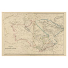
Antique Map of Tartary – Hand-Colored Lithograph of Central Asia, 1827
$428.32
£320.60
€360
CA$588.31
A$657.80
CHF 345.05
MX$7,967.59
NOK 4,355.53
SEK 4,114.92
DKK 2,740.78
About the Item
Antique Map of Tartary – Hand-Colored Lithograph of Central Asia, 1827
This original antique map, titled "Partie de la Tartarie" (No. 42), is an exceptional example of early 19th-century cartography by Philippe Marie Vandermaelen. It focuses on a largely uncharted region of Central Asia during the 1820s, covering parts of what is now southern Kazakhstan, stretching from the vicinity east of the Aral Sea toward the western extremities of Lake Balkhash.
Drawn at an impressively detailed uniform scale of 1:1,641,836, this lithographed map is part of Vandermaelen’s monumental Atlas Universel, one of the earliest atlases to use lithography and the first to map the entire known world on such a consistent scale. This map includes geographic and hydrographic features such as rivers, lakes, steppes, mountain ranges, and caravan routes, as well as settlements like Turkestan, Tashkent, and Khodjend. Prominent annotations include "Grande Horde de Kirghises" (Great Horde of the Kirghiz) and "Montagnes de Tarbagataï," reflecting contemporary European knowledge and nomenclature of this remote area.
Each sheet of Vandermaelen’s atlas was designed to fit together to form a massive globe over seven meters in diameter, making this work not just a scientific achievement but a grand geographical vision. This map's fine lithographic lines, delicately hand-colored borders, and meticulous detailing make it a historically rich and visually striking piece.
The map was produced at the Établissement Géographique de Bruxelles, Vandermaelen’s own printing and research facility, a pioneering center for geography, printing, and public education in Belgium. Its publication in 1827 places it among the earliest modern attempts to standardize and democratize global geographic knowledge.
Condition: Good condition with original hand-color in outline. Light age-toning and some marginal creases consistent with age. No tears or repairs. Strong paper quality with a clear plate impression.
Framing tips: Best displayed in a walnut or dark oak frame with a cream or light tan mat to enhance the subtle hand coloring. A minimalist or antique-style frame will emphasize the map’s historical character.
Technique: Lithograph with original hand color
Maker: Philippe Marie Vandermaelen, Brussels, 1827
- Dimensions:Height: 18.51 in (47 cm)Width: 20.28 in (51.5 cm)Depth: 0.01 in (0.2 mm)
- Materials and Techniques:Paper,Engraved
- Place of Origin:
- Period:
- Date of Manufacture:1827
- Condition:Condition: Good condition with original hand-color in outline. Light age-toning and some marginal creases consistent with age. No tears or repairs. Strong paper quality with a clear plate impression. Folding line as issued.
- Seller Location:Langweer, NL
- Reference Number:Seller: BG-13457-61stDibs: LU3054346159062
About the Seller
5.0
Recognized Seller
These prestigious sellers are industry leaders and represent the highest echelon for item quality and design.
Platinum Seller
Premium sellers with a 4.7+ rating and 24-hour response times
Established in 2009
1stDibs seller since 2017
2,565 sales on 1stDibs
Typical response time: <1 hour
- ShippingRetrieving quote...Shipping from: Langweer, Netherlands
- Return Policy
Authenticity Guarantee
In the unlikely event there’s an issue with an item’s authenticity, contact us within 1 year for a full refund. DetailsMoney-Back Guarantee
If your item is not as described, is damaged in transit, or does not arrive, contact us within 7 days for a full refund. Details24-Hour Cancellation
You have a 24-hour grace period in which to reconsider your purchase, with no questions asked.Vetted Professional Sellers
Our world-class sellers must adhere to strict standards for service and quality, maintaining the integrity of our listings.Price-Match Guarantee
If you find that a seller listed the same item for a lower price elsewhere, we’ll match it.Trusted Global Delivery
Our best-in-class carrier network provides specialized shipping options worldwide, including custom delivery.More From This Seller
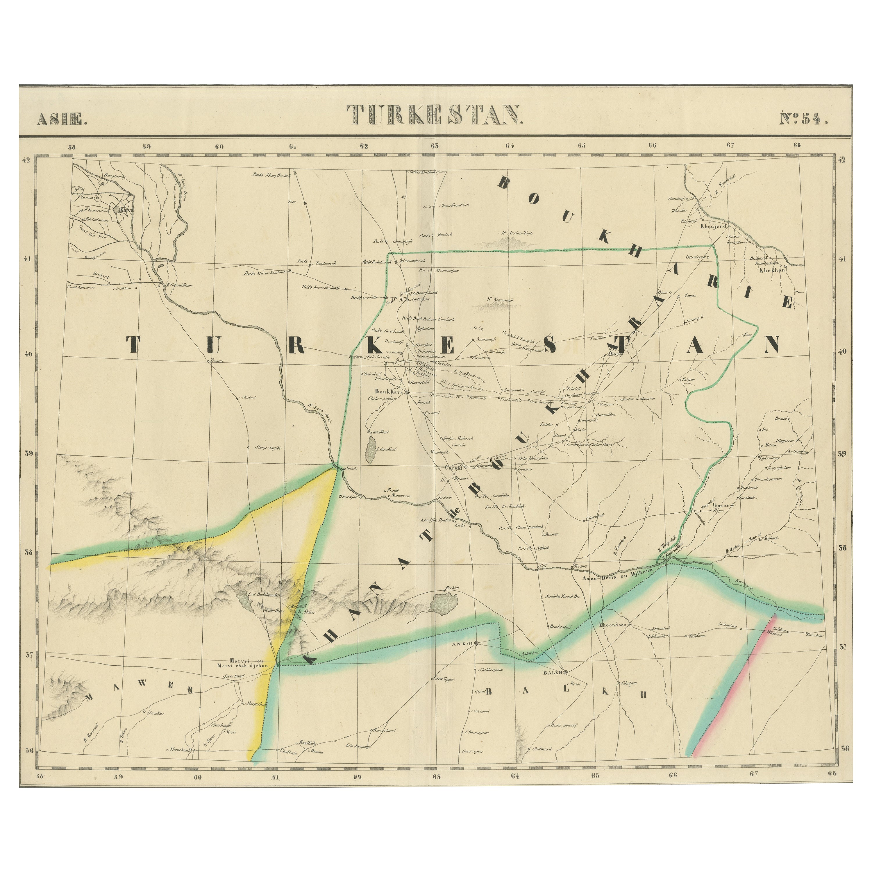
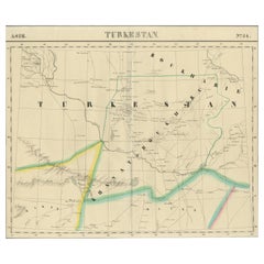
View AllAntique Map of Turkestan – Vandermaelen Lithograph of Central Asia, 1827
Located in Langweer, NL
Antique Map of Turkestan – Vandermaelen Lithograph of Central Asia, 1827
This finely detailed antique map titled “Turkestan” (No. 34) is an original lithograph from the groundbreaki...
Category
Antique Early 19th Century Belgian Maps
Materials
Paper
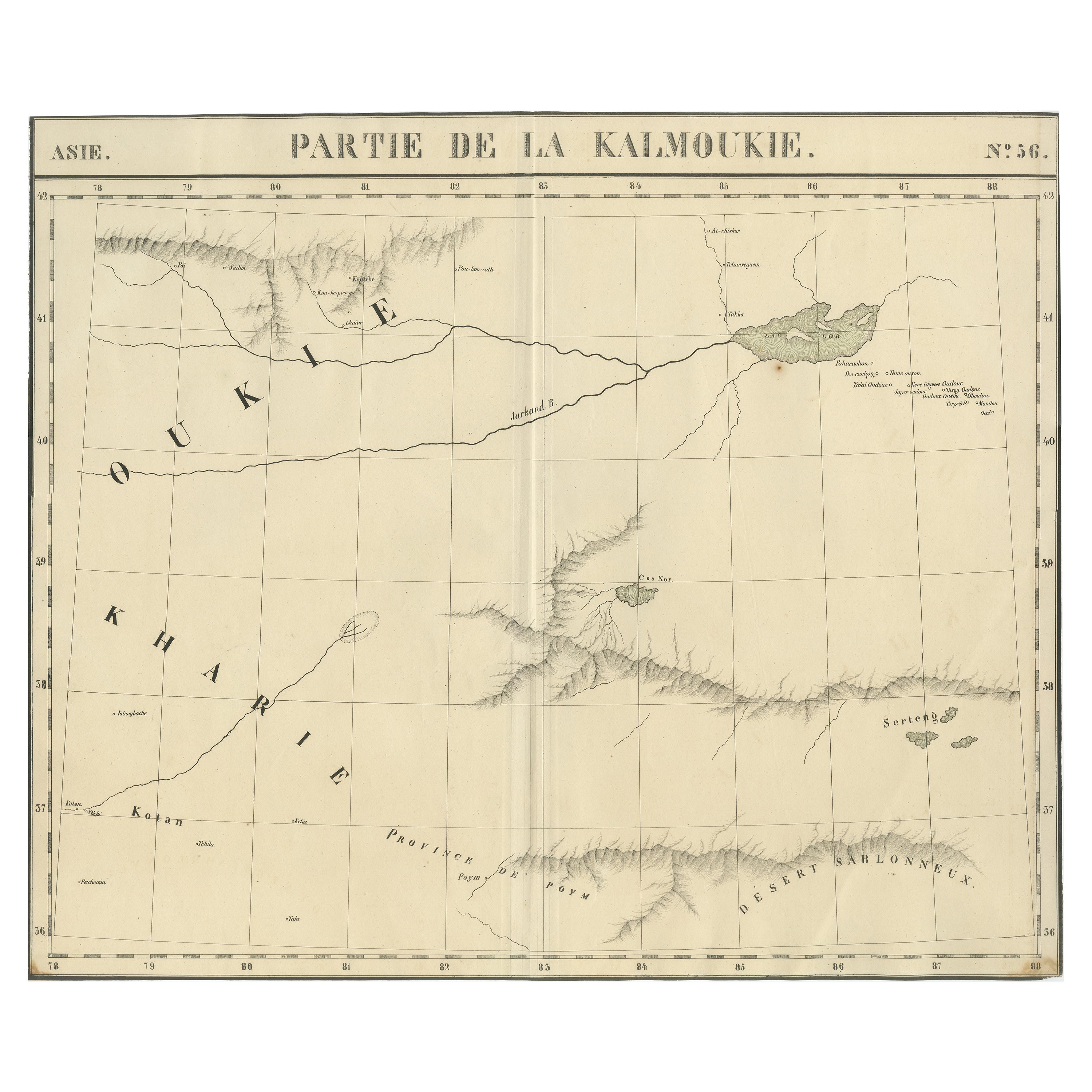
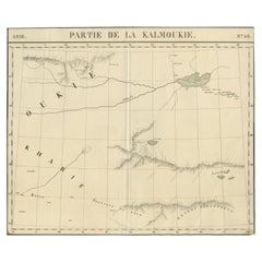
Antique Map of Kalmykia – Vandermaelen Lithograph of Central Asia, 1827
Located in Langweer, NL
Antique Map of Kalmykia – Vandermaelen Lithograph of Central Asia, 1827
This rare antique map titled “Partie de la Kalmoukie” (No. 56) is an original 1827 lithograph by Belgian cart...
Category
Antique Early 19th Century Belgian Maps
Materials
Paper
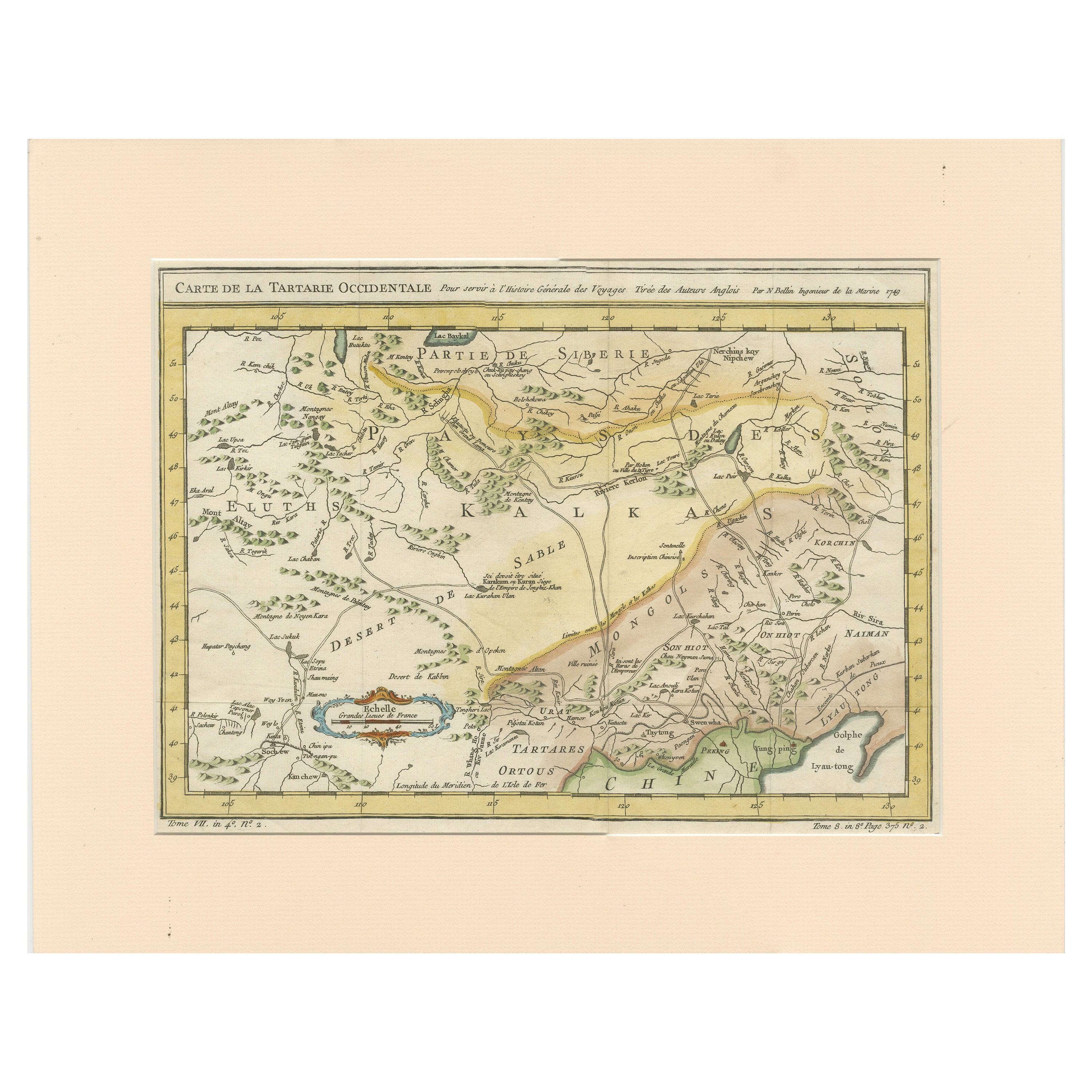
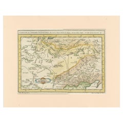
Antique Map of Tartary and Northeast Asia with Hand Coloring
Located in Langweer, NL
Antique map titled 'Carte de la Tartarie Occidentale'. An interesting map of Tartary and northeast Asia, from Lake Baykal, Partie du Siberia in the north, Pays des Kalkas at the cent...
Category
Antique Mid-18th Century Maps
Materials
Paper
$266 Sale Price
20% Off
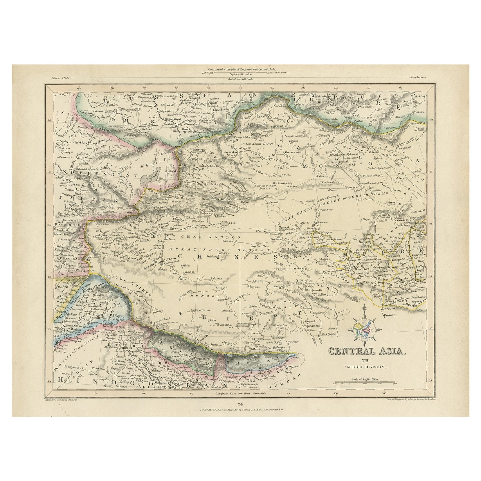
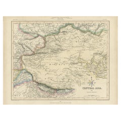
Antique Map of Central Asia, Finely Engraved, 1841
Located in Langweer, NL
Antique map titled 'Central Asia, Middle Division'. A finely engraved and attractive mid 19th Century map of Central Asia which was drawn and engraved by Joshua Archer and published ...
Category
Antique 19th Century Maps
Materials
Paper
$228 Sale Price
20% Off
Antique Map of Tartary and Northeast Asia, c.1750
Located in Langweer, NL
Antique map titled 'Carte de la tartarie occidentale'. An interesting map of Tartary and northeast Asia, from Lake Baykal, Partie du Siberia in the north, Pays des Kalkas at the cent...
Category
Antique 18th Century Maps
Materials
Paper

$123 Sale Price
20% Off
Antique Map of Independent Tartary by W. G. Blackie, 1859
Located in Langweer, NL
Antique map titled 'Turkestan or Independent Tartary'. Original antique map of Turkestan or Independent Tartary. This map originates from ‘The Imperial Atlas of Modern Geography’. Pu...
Category
Antique Mid-19th Century Maps
Materials
Paper
$237 Sale Price
20% Off
You May Also Like
Large Original Antique Map of Afghanistan. Edward Weller, 1861
Located in St Annes, Lancashire
Great map of Afghanistan
Lithograph engraving by Edward Weller
Original colour
Published, 1861
Unframed
Good condition
Category
Antique 1860s English Victorian Maps
Materials
Paper

1851 Map of "Independent Tartary", Ric. R018
Located in Norton, MA
1851 Map of
Independent Tartary
"Russia"
Ric.r018
A highly decorative 1851 map of Independent Tartary by John Tallis and John Rapkin. Covers the regions between the Caspian Sea and Lake Bakquash and between Russia and Afghanistan. These include the ancient Silk Route kingdoms of Khiva, Tartaria, Kokand, and Bokhara. Today this region roughly includes Kazakhstan, Uzbekistan, Turkmenistan, Kyrgyzstan, and Tajikistan. This wonderful map offers a wealth of detail for anyone with an interest in the Central Asian portion of the ancient Silk Road. Identifies various caravan routes, deserts, wells, and stopping points, including the cities of Bokhara and Samarkand. Three vignettes by W. Bragg decorate the map, these including an image of Tartars on a Journey, a horseback Bride Chase, and a tartar camp site. Surrounded by a vine motif border. Engraved by J. Rapkin for John Tallis's 1851 Illustrated Atlas .
Tartary Antique Map...
Category
Antique 19th Century Unknown Maps
Materials
Paper

Map of Campaign of 1814 - Etching by Pierre François Tardieu - 1837
Located in Roma, IT
Map of Campaign of 1814 is an Etching realized by Pierre François Tardieu in 1837.
Good conditions.
The artwork is realized in a well-balanced composition. the artwork and belongs ...
Category
1830s Modern Figurative Prints
Materials
Lithograph

1860 Large Map "Carte De La Siberie Russie D'asie, " Ric.R0001
Located in Norton, MA
Large 1860 map "Carte De La Siberie Russie D'Asie," R-0001
" Authentic" - 1860 map "Carte De La Siberie Russie D'Asie,"
Dimension: Paper: 68 cm W x 51 cm H ; Sight: 51cm W x 4...
Category
Antique 19th Century Unknown Maps
Materials
Paper

Pyrenees Orientales, France. Antique map of a French department, 1856
By Victor Levasseur
Located in Melbourne, Victoria
'Dept. des Pyrenees Orientales', steel engraving with original outline hand-colouring., 1856, from Levasseur's 'Atlas National Illustre'.
This area is well-known wine producing reg...
Category
19th Century Naturalistic Landscape Prints
Materials
Engraving

Original Antique Map of China, Arrowsmith, 1820
Located in St Annes, Lancashire
Great map of China
Drawn under the direction of Arrowsmith
Copper-plate engraving
Published by Longman, Hurst, Rees, Orme and Brown, 1820
Unfr...
Category
Antique 1820s English Maps
Materials
Paper
