Items Similar to Antique Map of the West Indies and Central America by W. G. Blackie, 1859


Want more images or videos?
Request additional images or videos from the seller
1 of 6
Antique Map of the West Indies and Central America by W. G. Blackie, 1859
$239.84
$299.7920% Off
£178.41
£223.0220% Off
€200
€25020% Off
CA$328.42
CA$410.5220% Off
A$365.16
A$456.4420% Off
CHF 190.66
CHF 238.3320% Off
MX$4,444.83
MX$5,556.0420% Off
NOK 2,432.79
NOK 3,040.9920% Off
SEK 2,279.41
SEK 2,849.2620% Off
DKK 1,522.49
DKK 1,903.1120% Off
Shipping
Retrieving quote...The 1stDibs Promise:
Authenticity Guarantee,
Money-Back Guarantee,
24-Hour Cancellation
About the Item
Antique map titled 'The West India Island & Central America'. Original antique map of the West Indies and Central America, with inset map of Jamaica. This map originates from ‘The Imperial Atlas of Modern Geography’. Published by W. G. Blackie, 1859.
- Dimensions:Height: 14.57 in (37 cm)Width: 21.26 in (54 cm)Depth: 0.02 in (0.5 mm)
- Materials and Techniques:
- Period:
- Date of Manufacture:1859
- Condition:Wear consistent with age and use. General age-related toning. some foxing, Please study image carefully.
- Seller Location:Langweer, NL
- Reference Number:Seller: BG-12685-1-771stDibs: LU3054325255032
About the Seller
5.0
Recognized Seller
These prestigious sellers are industry leaders and represent the highest echelon for item quality and design.
Platinum Seller
Premium sellers with a 4.7+ rating and 24-hour response times
Established in 2009
1stDibs seller since 2017
2,510 sales on 1stDibs
Typical response time: <1 hour
- ShippingRetrieving quote...Shipping from: Langweer, Netherlands
- Return Policy
Authenticity Guarantee
In the unlikely event there’s an issue with an item’s authenticity, contact us within 1 year for a full refund. DetailsMoney-Back Guarantee
If your item is not as described, is damaged in transit, or does not arrive, contact us within 7 days for a full refund. Details24-Hour Cancellation
You have a 24-hour grace period in which to reconsider your purchase, with no questions asked.Vetted Professional Sellers
Our world-class sellers must adhere to strict standards for service and quality, maintaining the integrity of our listings.Price-Match Guarantee
If you find that a seller listed the same item for a lower price elsewhere, we’ll match it.Trusted Global Delivery
Our best-in-class carrier network provides specialized shipping options worldwide, including custom delivery.More From This Seller
View AllOriginal Antique Map of the West Indies by J. Arrowsmith, 1842
Located in Langweer, NL
Title: "J. Arrowsmith's 19th Century Map of the West Indies"
This original antique map, crafted by J. Arrowsmith, details the West Indies with a focus on the Caribbean Sea and its s...
Category
Antique Early 19th Century Maps
Materials
Paper

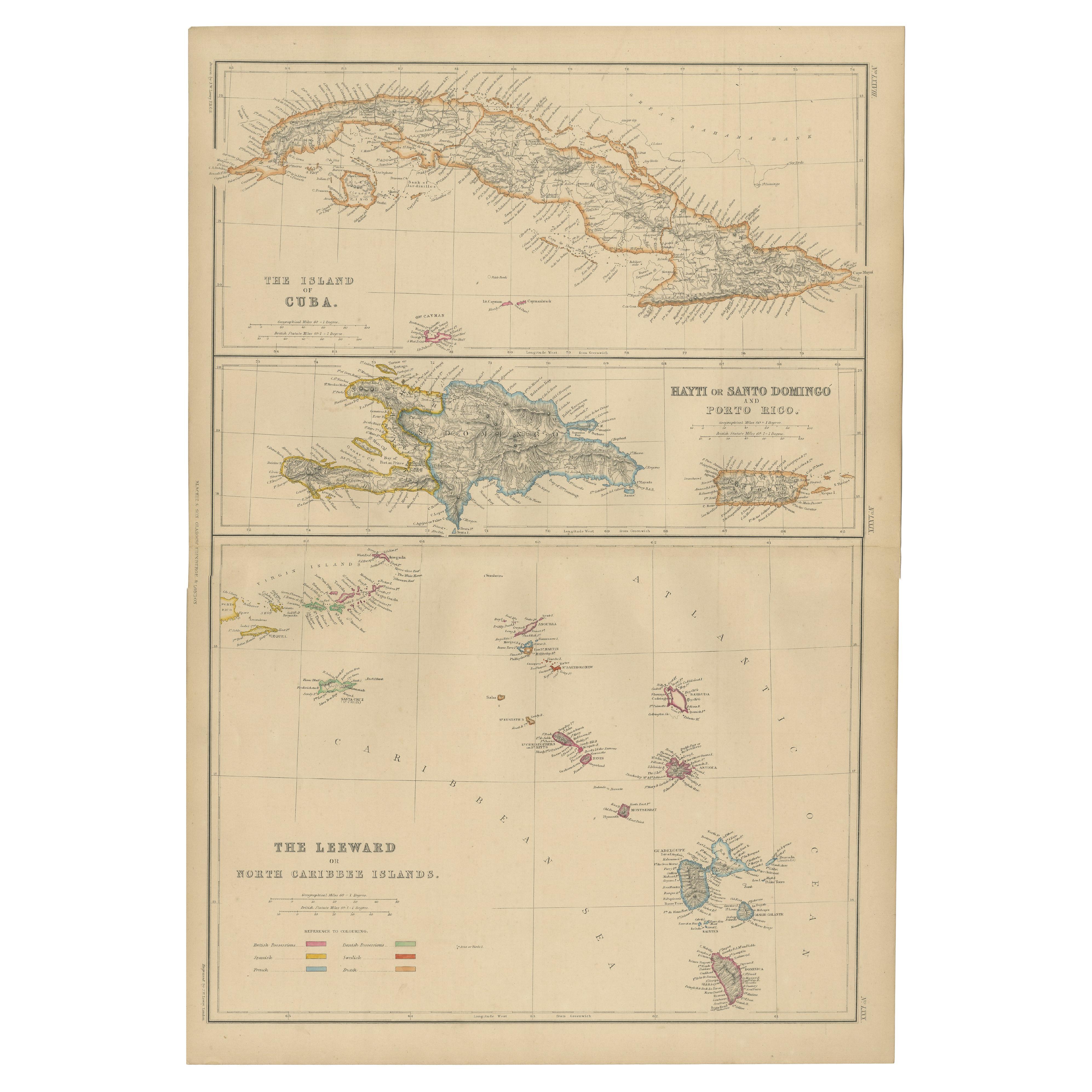
Antique Map of Cuba, Haiti and Porto Rico by W. G. Blackie, 1859
Located in Langweer, NL
Antique map titled 'The Leeward or North Caribbean Islands'. Original antique map of Cuba, Haiti and Porto Rico. This map originates from ‘The Imperial Atla...
Category
Antique Mid-19th Century Maps
Materials
Paper
$239 Sale Price
20% Off
Antique Map of the Antilles in the Caribbean, '1875'
Located in Langweer, NL
Antique map titled 'Carte des Iles Antilles'. Large map of the Antilles. This map originates from 'Atlas de Géographie Moderne Physique et Politique' by A. Levasseur. Published, 1875.
Category
Antique Late 19th Century Maps
Materials
Paper

$359 Sale Price
40% Off
Antique Map of the Antilles and Central America – 1872
Located in Langweer, NL
Title: Antique Map of the Antilles and Central America – 1872
Description:
This finely detailed antique map, titled Antilles et Amérique Centrale, was published in 1872 under t...
Category
Antique 1870s Maps
Materials
Paper

Antique Map of the West Indies and Central America by Lowry '1852'
Located in Langweer, NL
Antique map titled 'West Indies and Central America'. Original map of the West Indies and Central America. This map originates from 'Lowry's Table Atlas constructed and engraved from...
Category
Antique Mid-19th Century Maps
Materials
Paper

$95 Sale Price
20% Off
Antique Map of Mexico, Central America and West Indies by A & C. Black, 1870
Located in Langweer, NL
Antique map titled 'Mexico, Central America and West Indies'. Original antique map of Mexico, Central America and West Indies with inset map of Panama railway. This map originates fr...
Category
Antique Late 19th Century Maps
Materials
Paper

$167 Sale Price
20% Off
You May Also Like
Large Original Antique Map of The West Indies by Sidney Hall, 1847
Located in St Annes, Lancashire
Great map of The West Indies
Drawn and engraved by Sidney Hall
Steel engraving
Original colour outline
Published by A & C Black. 1847
Unframed
Free shipping.
Category
Antique 1840s Scottish Maps
Materials
Paper

Original Antique Map of Central America / Florida, Arrowsmith, 1820
Located in St Annes, Lancashire
Great map of Central America.
Drawn under the direction of Arrowsmith.
Copper-plate engraving.
Published by Longman, Hurst, Rees, Orme and Brown, 1820
Unframed.
Category
Antique 1820s English Maps
Materials
Paper

Large Original Antique Map of The Bahamas. 1894
Located in St Annes, Lancashire
Superb Antique map of The Bahamas
Published Edward Stanford, Charing Cross, London 1894
Original colour
Good condition
Unframed.
Free shipping
Category
Antique 1890s English Maps
Materials
Paper

Large Original Antique Map of The Leeward Islands. 1894
Located in St Annes, Lancashire
Superb Antique map of The Leeward Islands
Published Edward Stanford, Charing Cross, London 1894
Original colour
Good condition
Unframed.
Free shipping
Category
Antique 1890s English Maps
Materials
Paper

Map Colonies Francaises Martinique, 1845
Located in BUNGAY, SUFFOLK
Colonies Francaises, Martinique, Amerique DU SUD
Geographie et Statistique par V.Levasseur. Ing'r Geographe.
Illustre par Raymond Bonheur, peintre.
Grave par Laguihermie, Rue St...
Category
Antique 19th Century French Maps
Materials
Paper

Large Original Antique Map of the The Windward Islands. 1894
Located in St Annes, Lancashire
Superb Antique map of The Windward Islands
Published Edward Stanford, Charing Cross, London 1894
Original colour
Good condition
Unframed.
Free shipping
Category
Antique 1890s English Maps
Materials
Paper

More Ways To Browse
West Indies Furniture
West Indies Antique Furniture
Used Furniture Jamaica
Antique Maps West Indies
Jamaican Antique
Map Of Jamaica
Caribbean Antiques
Antique Map Of Ireland
Ships Log
Map Of Egypt
Nautical Maps
Antique Maps Of Long Island
James Cook Map
Antique Doctors Office Furniture
Pirate Furniture
Railroad Collectibles
Antique Map Mexico
Framed Map Of Paris