Items Similar to Antique Miniature Map of the Western Hemisphere, with California as an Island


Want more images or videos?
Request additional images or videos from the seller
1 of 6
Antique Miniature Map of the Western Hemisphere, with California as an Island
$421.75
$527.1820% Off
£313.90
£392.3820% Off
€352
€44020% Off
CA$577.69
CA$722.1120% Off
A$642.51
A$803.1420% Off
CHF 335.50
CHF 419.3820% Off
MX$7,818.72
MX$9,773.4020% Off
NOK 4,284.86
NOK 5,356.0820% Off
SEK 4,018.44
SEK 5,023.0520% Off
DKK 2,679.65
DKK 3,349.5720% Off
Shipping
Retrieving quote...The 1stDibs Promise:
Authenticity Guarantee,
Money-Back Guarantee,
24-Hour Cancellation
About the Item
Antique miniature map titled 'Nouveau Continent avec plusieurs Isles et Mers'. Decorative map of the Western Hemisphere, published by Alain Manesson Mallet. The map shows California as an Island, no Northwest Coast of America and an incomplete New Zealand. This map originates from 'Description de l' Univers', published circa 1683.
Alain Mannesson Mallet (1630-1706) was a French mapmaker and engineer who served in the armies of Louis XIV. After rising through the ranks, Mallet was appointed as Inspector of Fortifications, a job which also required mathematical skills and which made him a competent military engineer. Eventually, he joined the court of Louis XIV at Versailles, where he taught math and focused on writing.
- Dimensions:Height: 8.27 in (21 cm)Width: 5.6 in (14.2 cm)Depth: 0.02 in (0.5 mm)
- Materials and Techniques:
- Period:Late 17th Century
- Date of Manufacture:circa 1683
- Condition:Wear consistent with age and use. General age-related toning, minor wear and soiling. French text on verso. Please study image carefully.
- Seller Location:Langweer, NL
- Reference Number:Seller: BG-132191stDibs: LU3054333117952
About the Seller
5.0
Recognized Seller
These prestigious sellers are industry leaders and represent the highest echelon for item quality and design.
Platinum Seller
Premium sellers with a 4.7+ rating and 24-hour response times
Established in 2009
1stDibs seller since 2017
2,508 sales on 1stDibs
Typical response time: <1 hour
- ShippingRetrieving quote...Shipping from: Langweer, Netherlands
- Return Policy
Authenticity Guarantee
In the unlikely event there’s an issue with an item’s authenticity, contact us within 1 year for a full refund. DetailsMoney-Back Guarantee
If your item is not as described, is damaged in transit, or does not arrive, contact us within 7 days for a full refund. Details24-Hour Cancellation
You have a 24-hour grace period in which to reconsider your purchase, with no questions asked.Vetted Professional Sellers
Our world-class sellers must adhere to strict standards for service and quality, maintaining the integrity of our listings.Price-Match Guarantee
If you find that a seller listed the same item for a lower price elsewhere, we’ll match it.Trusted Global Delivery
Our best-in-class carrier network provides specialized shipping options worldwide, including custom delivery.More From This Seller
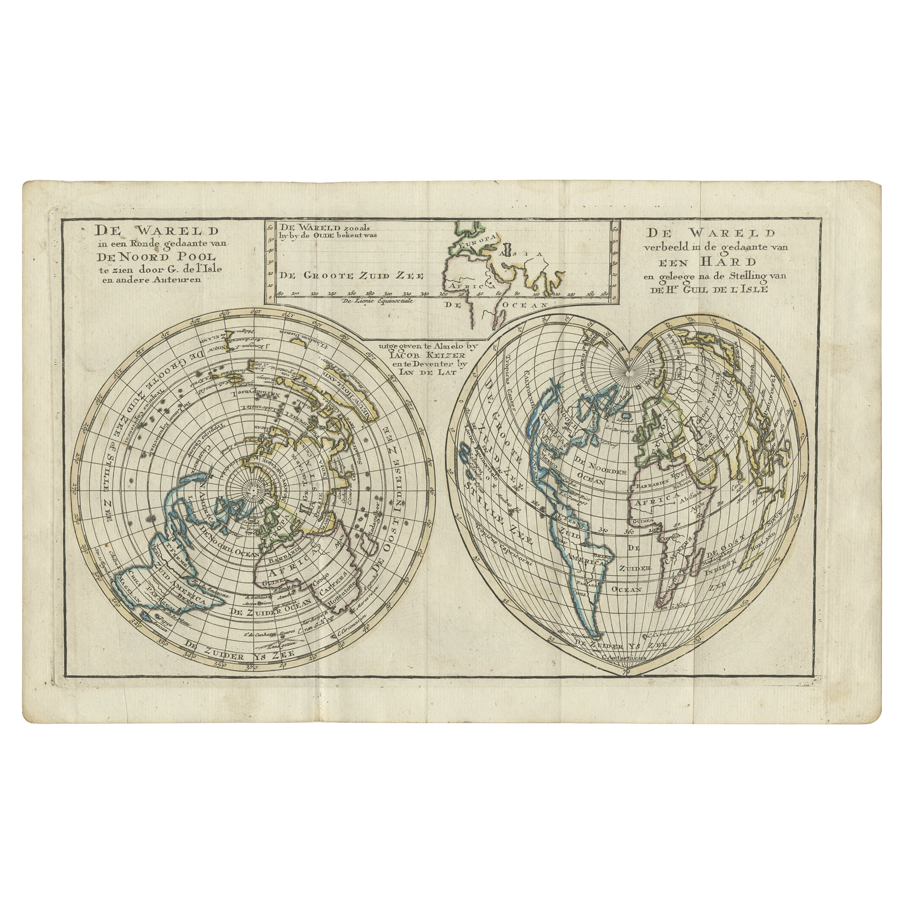
View AllAntique Map of the World with California as an Island, 1788
Located in Langweer, NL
Description: Antique map titled 'De wareld in een ronde gedaante van de Noord Pool te zien - De Wareld verbeeld in de gedaante van een hard'. This interesting composition contains three world maps on the sheet. At left is a northern projection showing all the landmasses. At right is a cordiform projection (heart-shaped). At top is a map of the world as known to the ancients. Both the polar and cordiform projections show California as an island...
Category
Antique 1780s Maps
Materials
Paper

$623 Sale Price
20% Off
Antique Map of America with California as an Island by Homann '1710'
Located in Langweer, NL
This antique map, titled "Totius Americae Septentrionalis et Meridionalis," represents a significant cartographic piece from 1710 by Johann Baptist Homann. Here's a description of this remarkable map:
- Title: Totius Americae Septentrionalis et Meridionalis (...)
- Date: Published in 1710 by Johann Baptist Homann.
Description:
This map is a first edition of Johann Baptiste Homann's map of America, and it is notable for several cartographic features and historical representations:
1. California as an Island...
Category
Antique Early 18th Century Maps
Materials
Paper

$2,246 Sale Price
25% Off
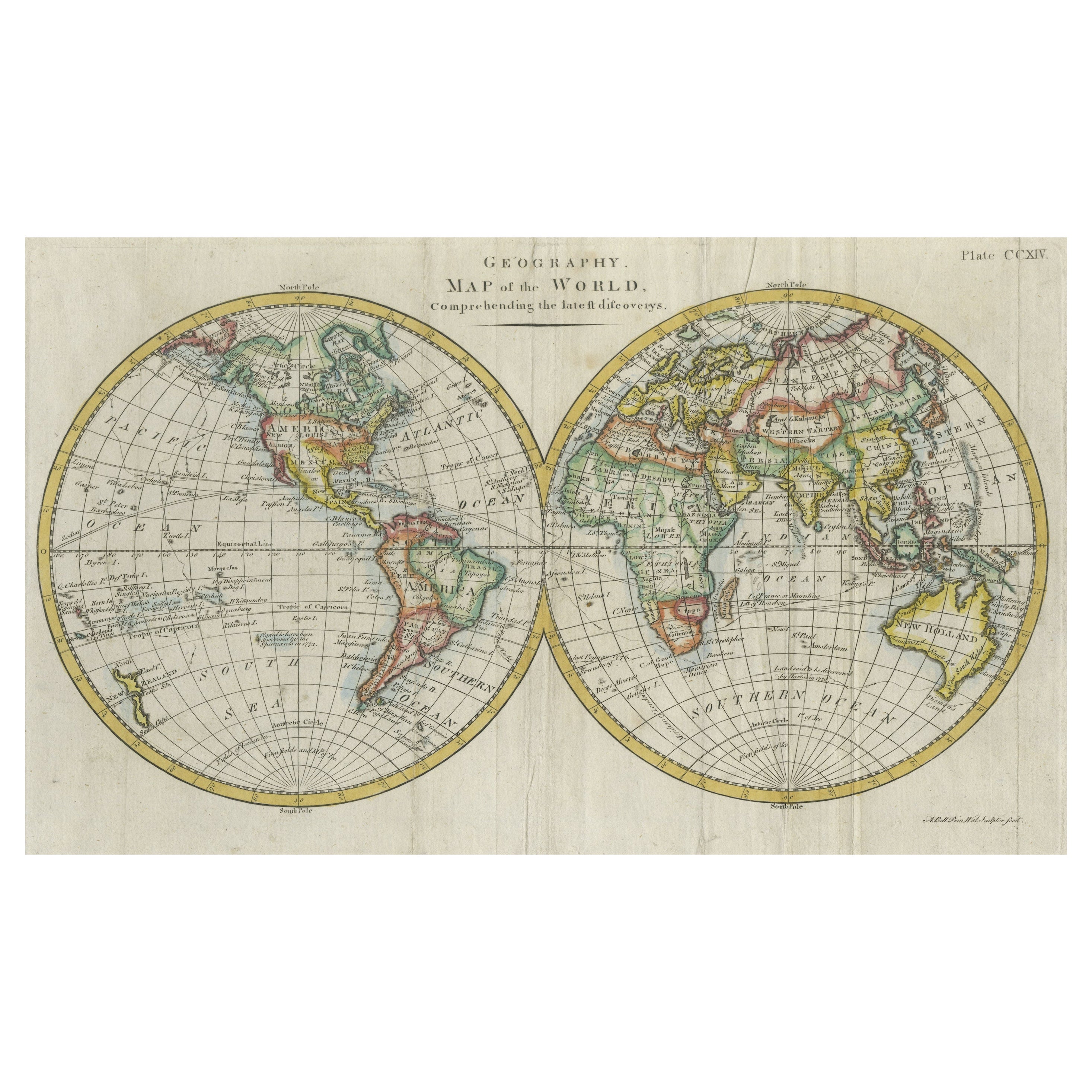
Interesting Original Antique Hemisphere Map Showing the Latest Discoveries
Located in Langweer, NL
Antique world map titled 'A Map of the World from the best Authorities'. Detailed map of the World, showing tracks of Captain James Cook in his 3 voyages in great detail. The map is ...
Category
Antique Late 18th Century Maps
Materials
Paper

$1,054 Sale Price
20% Off
Antique Map of the Eastern Hemisphere by Valk & Chenk '1708'
Located in Langweer, NL
Antique map titled 'Hemispherium Orbis Antiqui, Cumzonis Circulis, Et Sity populorum Diverso'. Decorative example of Andreas Cellarius's map of the Eastern Hemisphere, illustrating with climatic zones ranging from Frigida Borealis to Torrida, with planetary details superimposed. The elaborate border includes fine scrollwork, numerous putti, and additional diagrams showing armillary spheres and climatic zones. Andreas Cellarius was born in 1596 in Neuhausen and educated in Heidelberg. He emigrated to Holland in the early 17th century and 1637 moved to Hoorn, where he became the rector of the Latin School. Cellarius' best known work is his Harmonia Macrocosmica, first issued in 1660 by Jan Jansson, as a supplement to Jansson's Atlas Novus. The work consists of a series of Celestial Charts...
Category
Antique Early 18th Century Dutch Maps
Materials
Paper

$4,043 Sale Price
25% Off
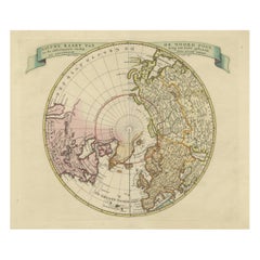
Beautiful Antique Map of the Northern Hemisphere with California as an Island
By Isaak Tirion
Located in Langweer, NL
Antique map titled 'Nieuwe Kaart van de Noord Pool na de alderlaatste ontdekking int licht gebracht tot Amsterdam door Isaak Tirion'. Beautiful map of the Northern Hemisphere and Nor...
Category
Antique Mid-18th Century Maps
Materials
Paper
$690 Sale Price
20% Off
Antique Map of the World on Mercator's Projection, 1788
Located in Langweer, NL
Antique map titled 'Kaart van de Geheele Wereld (..)'. Uncommon small world map on Mercator's projection. Nice detail of the islands throughout the wor...
Category
Antique Late 18th Century Maps
Materials
Paper

$718 Sale Price
20% Off
You May Also Like
North & South America: A 17th Century Hand-colored Map by Jansson & Goos
By Johannes Janssonius
Located in Alamo, CA
A 17th century hand-colored map of North & South America entitled "Americae Descriptio" by the cartographer Johannes Jansson, published in Jansson's Atlas Minor in Amsterdam in 1628....
Category
Antique 1620s Dutch Maps
Materials
Paper

Original Antique Map of The World by Thomas Clerk, 1817
Located in St Annes, Lancashire
Great map of The Eastern and Western Hemispheres
On 2 sheets
Copper-plate engraving
Drawn and engraved by Thomas Clerk, Edinburgh.
Published by Mackenzie And Dent, 1817
...
Category
Antique 1810s English Maps
Materials
Paper

California, Alaska and Mexico: 18th Century Hand-Colored Map by de Vaugondy
By Didier Robert de Vaugondy
Located in Alamo, CA
This is an 18th century hand-colored map of the western portions of North America entitled "Carte de la Californie et des Pays Nord-Ouest separés de l'Asie par le détroit d'Anian, ex...
Category
Antique 1770s French Maps
Materials
Paper

Original Antique Map of The Western Hemisphere by Dower, circa 1835
Located in St Annes, Lancashire
Nice map of the Western Hemisphere
Drawn and engraved by J.Dower
Published by Orr & Smith. C.1835
Unframed.
Free shipping
Category
Antique 1830s English Maps
Materials
Paper

Original Antique Map of South America. C.1780
Located in St Annes, Lancashire
Great map of South America
Copper-plate engraving
Published C.1780
Two small worm holes to left side of map
Unframed.
Category
Antique Early 1800s English Georgian Maps
Materials
Paper

Early 19th Century Hand Coloured Map of North America by Aaron Arrowsmith
By Aaron Arrowsmith
Located in Hamilton, Ontario
Hand coloured map in French by English cartographer Aaron Arrowsmith (1750–1823) titled "Amerique Septentionale" (North America).
Map size: 9.5" x 8"
Mat size: 20.5" x 14.25".
Category
Antique Early 19th Century English Maps
Materials
Paper

$795 Sale Price
36% Off
More Ways To Browse
Antique Furniture California
Antique French Miniature
American Antiques 17th Century
Tipu Sultan
Antique Map Bermuda
Antique Map Holder
Lancashire Map
Maltese Falcon
Raised Relief Map
William Dampier
Antique Chesapeake Bay Map
Astrology Map
Mauritius Antique Map
Oman Map
Tanzania Antique Map
Georgetown Map
Nova Hollandia
Aden Yemen