Items Similar to Antique Plan of Alicante Bay, Spain


Want more images or videos?
Request additional images or videos from the seller
1 of 6
Antique Plan of Alicante Bay, Spain
$510.39
$637.9820% Off
£382.57
£478.2120% Off
€432
€54020% Off
CA$701.19
CA$876.4820% Off
A$782.81
A$978.5120% Off
CHF 410.18
CHF 512.7220% Off
MX$9,582.34
MX$11,977.9220% Off
NOK 5,209.28
NOK 6,511.6120% Off
SEK 4,911.69
SEK 6,139.6220% Off
DKK 3,288.54
DKK 4,110.6820% Off
About the Item
Antique map titled 'Plan de la Baye d'Alicant'. Black and white harbor chart /port plan of Alicante Bay, Spain. This map originates from the scarce atlas 'Recueil de Plusiers Plans des Ports et Rades et de Quelque Cartes Particulieres de la Mer Méditerranée' by Jacques Ayrouard. Published circa 1746.
- Dimensions:Height: 13.51 in (34.3 cm)Width: 20.67 in (52.5 cm)Depth: 0.02 in (0.5 mm)
- Materials and Techniques:
- Period:
- Date of Manufacture:c.1746
- Condition:General age-related toning. Original folding line. Minor wear and soiling, blank verso. Please study image carefully.
- Seller Location:Langweer, NL
- Reference Number:Seller: BG-13432-31stDibs: LU3054335982412
About the Seller
5.0
Recognized Seller
These prestigious sellers are industry leaders and represent the highest echelon for item quality and design.
Platinum Seller
Premium sellers with a 4.7+ rating and 24-hour response times
Established in 2009
1stDibs seller since 2017
2,513 sales on 1stDibs
Typical response time: <1 hour
- ShippingRetrieving quote...Shipping from: Langweer, Netherlands
- Return Policy
Authenticity Guarantee
In the unlikely event there’s an issue with an item’s authenticity, contact us within 1 year for a full refund. DetailsMoney-Back Guarantee
If your item is not as described, is damaged in transit, or does not arrive, contact us within 7 days for a full refund. Details24-Hour Cancellation
You have a 24-hour grace period in which to reconsider your purchase, with no questions asked.Vetted Professional Sellers
Our world-class sellers must adhere to strict standards for service and quality, maintaining the integrity of our listings.Price-Match Guarantee
If you find that a seller listed the same item for a lower price elsewhere, we’ll match it.Trusted Global Delivery
Our best-in-class carrier network provides specialized shipping options worldwide, including custom delivery.More From This Seller
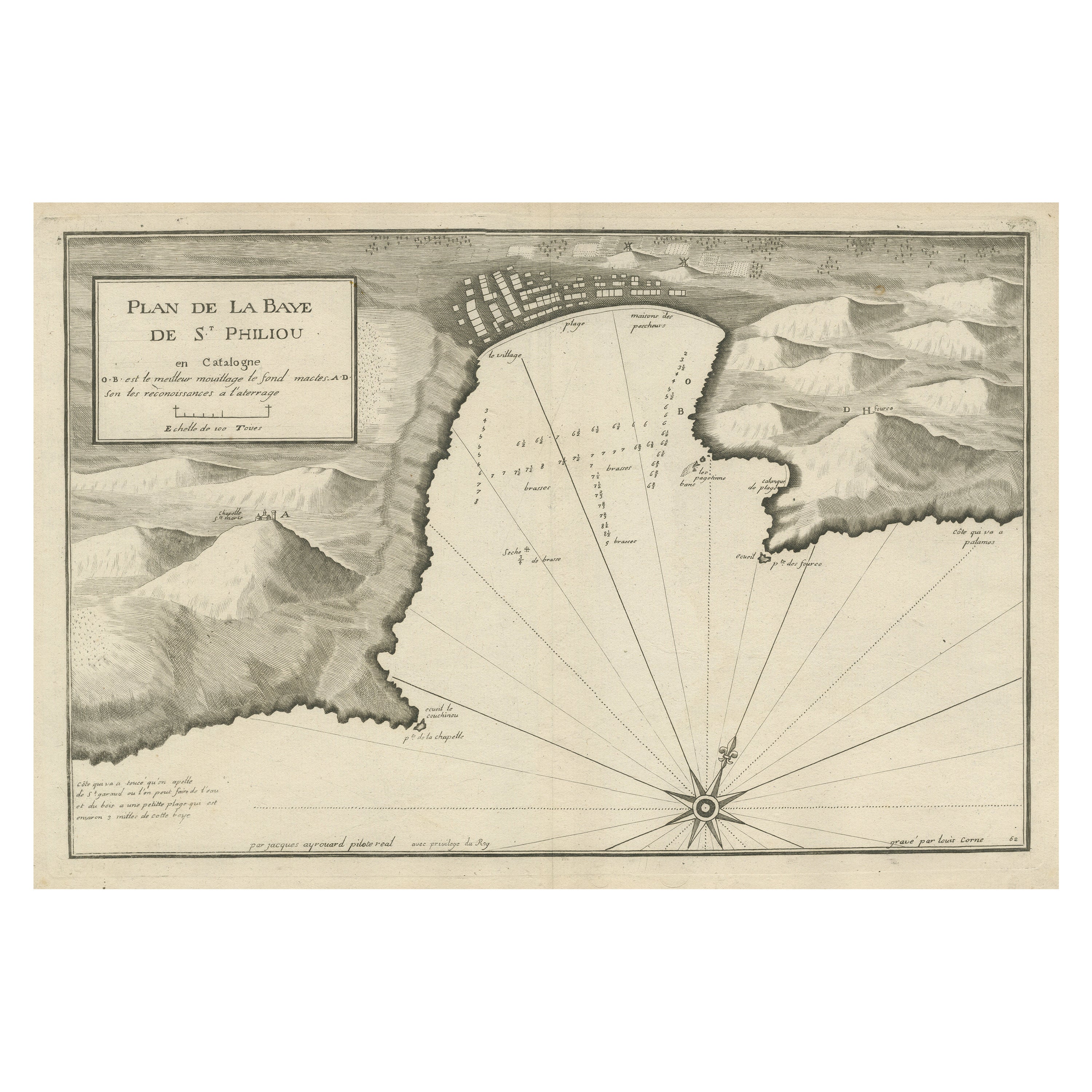
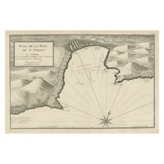
View AllLarge Antique Plan of St. Philiou Bay or Sant Feliu Catalonia Spain, circa 1746
Located in Langweer, NL
This antique map is a black and white harbor chart, specifically a port plan of St. Philiou, which is likely associated with Sant Feliu, Spain. This historical cartographic piece ori...
Category
Antique Mid-18th Century Maps
Materials
Paper
$510 Sale Price
20% Off
Free Shipping
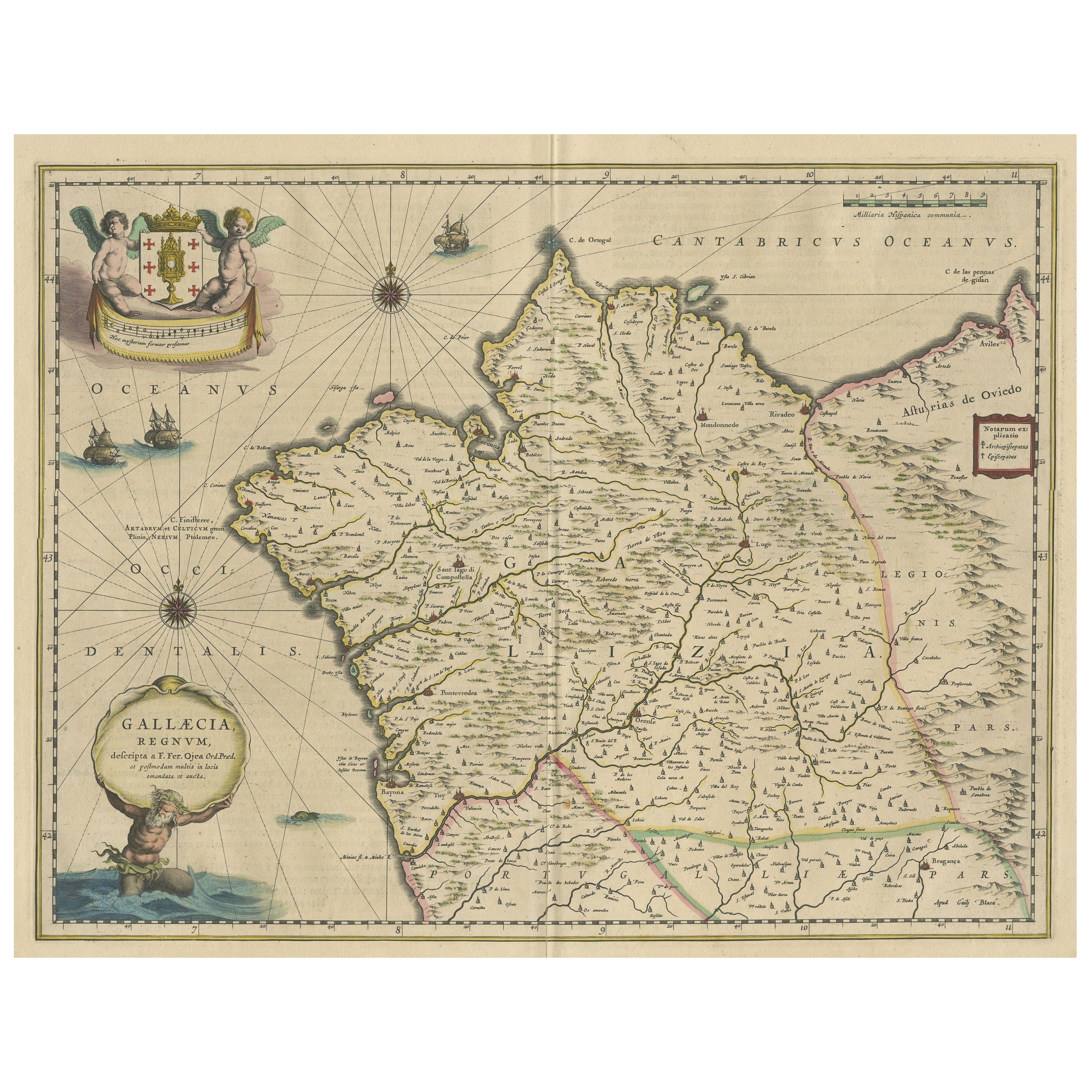
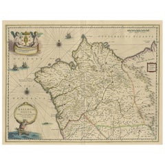
Antique Map of the Northwestern Coast of Spain
Located in Langweer, NL
Antique map titled 'Gallaecia Regnum'. Original old map of the northwestern coast of Spain, extending from the Asturias de Oviedo region and Aviles in the Northeast to Bayona and the...
Category
Antique Mid-17th Century Maps
Materials
Paper
$548 Sale Price
20% Off
Antique Map of a Bay on the Coast of Chile, South America, c.1749
Located in Langweer, NL
Antique map titled 'Plan van een Baai en Haven aan de Kust van Chili (..) - Plan d'une Baye de la Côte du Chili (..)'. Original antique map of a bay on the coast of Chile discovered ...
Category
Antique 18th Century Maps
Materials
Paper

$302 Sale Price
20% Off
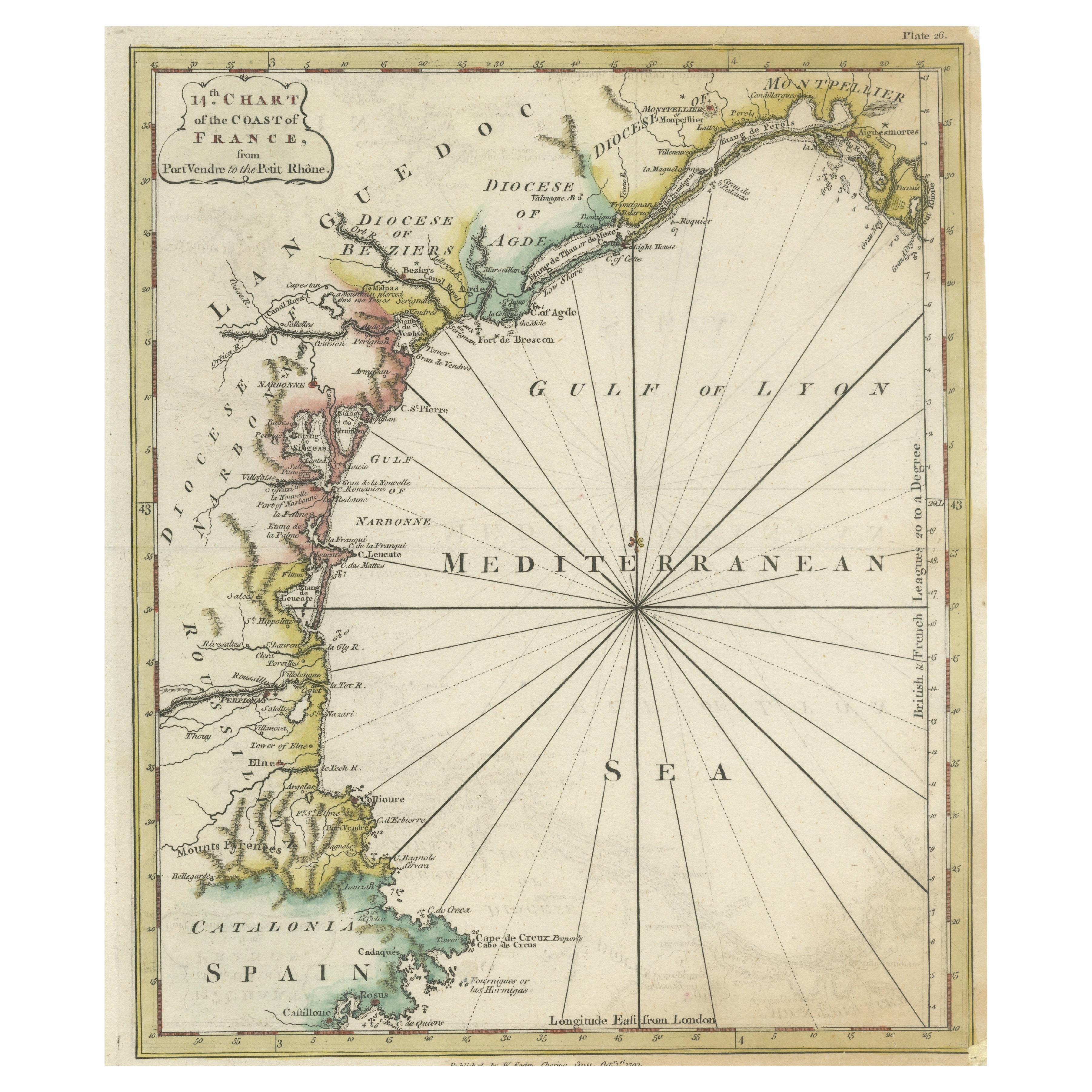
Antique Map of the Coast of Southern France, 1793
Located in Langweer, NL
Antique map titled '14th Chart of the Coast of France, from Port Vendres to the Petit Rhône'. Original map with later hand coroling of the coast of Southern France.
The "14th Chart of the Coast of France, from Port Vendres to the Petit Rhône" is an antique map that offers a detailed depiction of the southern coast of France, specifically highlighting the Mediterranean coastline. This map, which dates back to 1793, was originally part of "Le Petit Neptune Français; Or, French Coasting Pilot," a publication designed for maritime navigation along the French coastlines.
Key Features of the Map:
1. **Geographic Coverage**:
- The map covers the southern French coastline from Port Vendres in the west to the Petit Rhône in the east.
- It includes notable regions such as Languedoc, the Gulf of Lyon, and parts of Catalonia (Spain).
2. **Notable Places**:
- **Montpellier**: A major city in the Diocese of Montpellier, an important cultural and economic center.
- **Narbonne**: Located in the Diocese of Narbonne, a historical city with Roman heritage.
- **Agde**: Situated in the Diocese of Agde, known for its ancient Greek colony origins.
- **Béziers**: Part of the Diocese of Béziers, another city with deep historical roots dating back to Roman times.
- **Port Vendres**: A critical port near the Spanish border.
- **Catalonia**: Including parts of northeastern Spain, emphasizing the coastal connection between France and Spain.
3. **Dioceses and Regions**:
- The map is marked with various dioceses such as Montpellier, Agde, Narbonne, and Béziers, indicating ecclesiastical boundaries.
- It highlights the broader region of Languedoc, a historical province known for its wine production and medieval history.
4. **Navigational Aids**:
- The map features a compass rose with radiating lines, a common navigational aid in maritime maps...
Category
Antique Late 18th Century Maps
Materials
Paper

$226 Sale Price
20% Off
Antique Map of the Coast of Juan Fernandez by Van Schley, 1757
Located in Langweer, NL
Antique map titled 'Cote du Nord Est de l'Isle de Juan Fernandez (..).' Map of the Chilean South Pacific archipelago of the Juan Fernandez Islands. This island was made famous by Dan...
Category
Antique 18th Century Maps
Materials
Paper

$135 Sale Price
20% Off
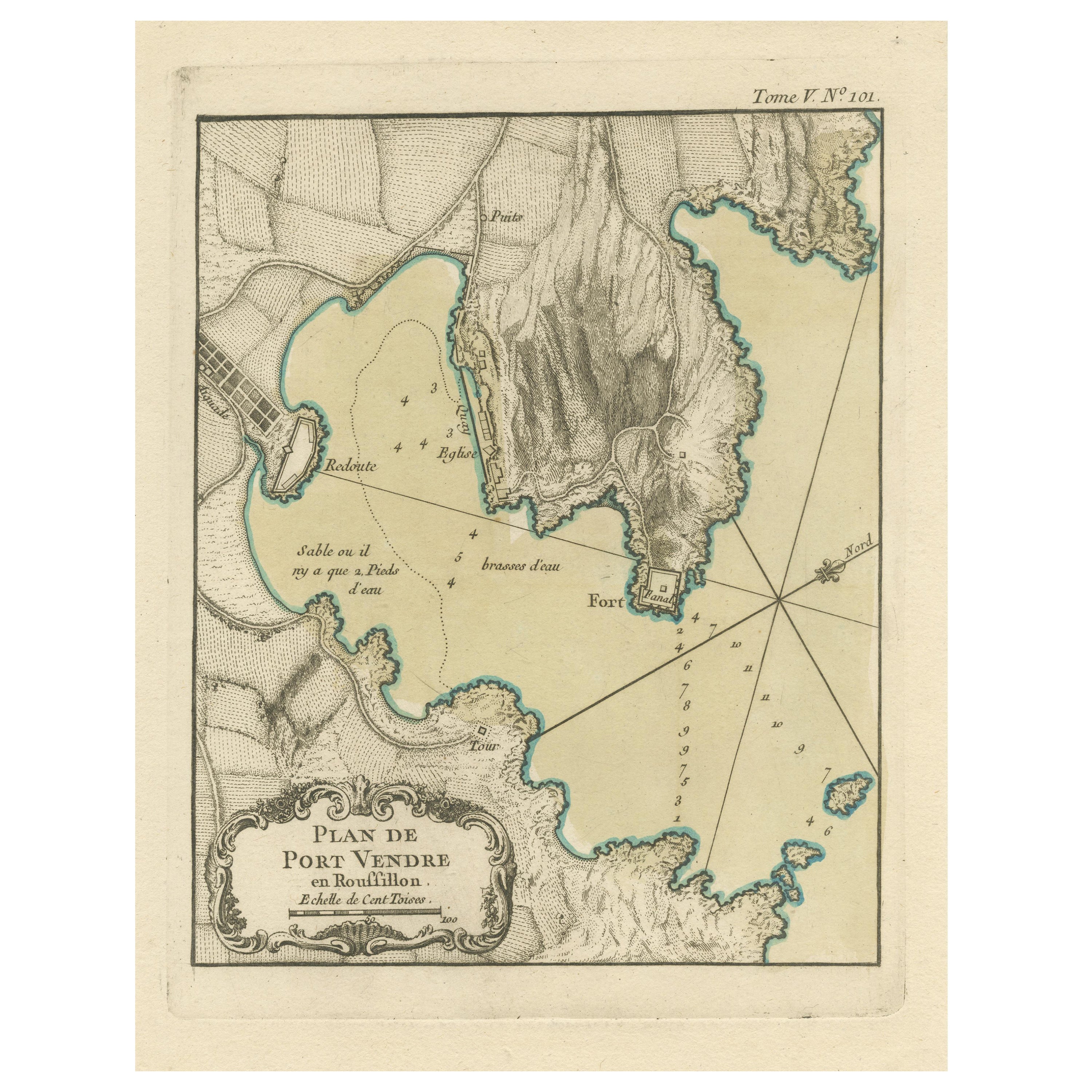
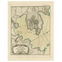
Antique Plan of Port-Vendres, Roussillon, France
Located in Langweer, NL
Antique map titled 'Plan de Port Vendre en Roussillon'. Original plan of Port-Vendres, Roussillon, France. This map originates from 'Le Petit Atlas Maritime (..)' by J.N. Bellin. Pub...
Category
Antique Mid-18th Century Maps
Materials
Paper
$321 Sale Price
20% Off
You May Also Like
Large Original Antique Map of The Canary Islands. 1894
Located in St Annes, Lancashire
Superb Antique map of The Canary Islands
Published Edward Stanford, Charing Cross, London 1894
Original colour
Good condition
Unframed.
Free shipping
Category
Antique 1890s English Maps
Materials
Paper

1844 French Antique Nautical Portolan of Plan du Port de Cherfe by Antoine Roux
By Antoine Roux
Located in Milan, IT
Antique portolano, nautical map of Plan du Port de Cherfe engraved on a copper plate by Antoine Roux, Marseille France 1844, from his work Recueil des principaux plans des ports et d...
Category
Antique 1840s French Nautical Objects
Materials
Paper

Original Antique Map of South America. C.1780
Located in St Annes, Lancashire
Great map of South America
Copper-plate engraving
Published C.1780
Two small worm holes to left side of map
Unframed.
Category
Antique Early 1800s English Georgian Maps
Materials
Paper

West Coast of Africa, Guinea & Sierra Leone: An 18th Century Map by Bellin
By Jacques-Nicolas Bellin
Located in Alamo, CA
Jacques Bellin's copper-plate map entitled "Partie de la Coste de Guinee Dupuis la Riviere de Sierra Leona Jusquau Cap das Palmas", depicting the coast of Guinea and Sierra Leone in ...
Category
Antique Mid-18th Century French Maps
Materials
Paper

Geographical Antique Map of Principality of Monaco
By Bruno Santini
Located in Alessandria, Piemonte
ST/609 - Interesting antique color map of Monaco Principality in French language : "Carte qui contient le Principauté de Piémont, le Monferrat et la comté de...
Category
Antique Late 18th Century Italian Other Maps
Materials
Paper

California, Alaska and Mexico: 18th Century Hand-Colored Map by de Vaugondy
By Didier Robert de Vaugondy
Located in Alamo, CA
This is an 18th century hand-colored map of the western portions of North America entitled "Carte de la Californie et des Pays Nord-Ouest separés de l'Asie par le détroit d'Anian, ex...
Category
Antique 1770s French Maps
Materials
Paper

More Ways To Browse
Giacometti Chairs
Antique Rug Wool Navy Blue Red
Bauhaus Flower Stand
French Table With Drawers
North Carolina Furniture
Antique Silver Platter
Boat Blueprint
Cream Plates
Vintage Art Deco Rugs
Vintage Serving Forks
Brewery Signs
Herati Rug
Venice Wood
Gold Leaf Furniture Black
Italian Wood Console Tables
Maison Jansen Argentina
Antique Oushak
Mid Century Danish Directors Chairs