Items Similar to Antique Plan of the Harbour of Taloo by Cook, c.1781


Want more images or videos?
Request additional images or videos from the seller
1 of 6
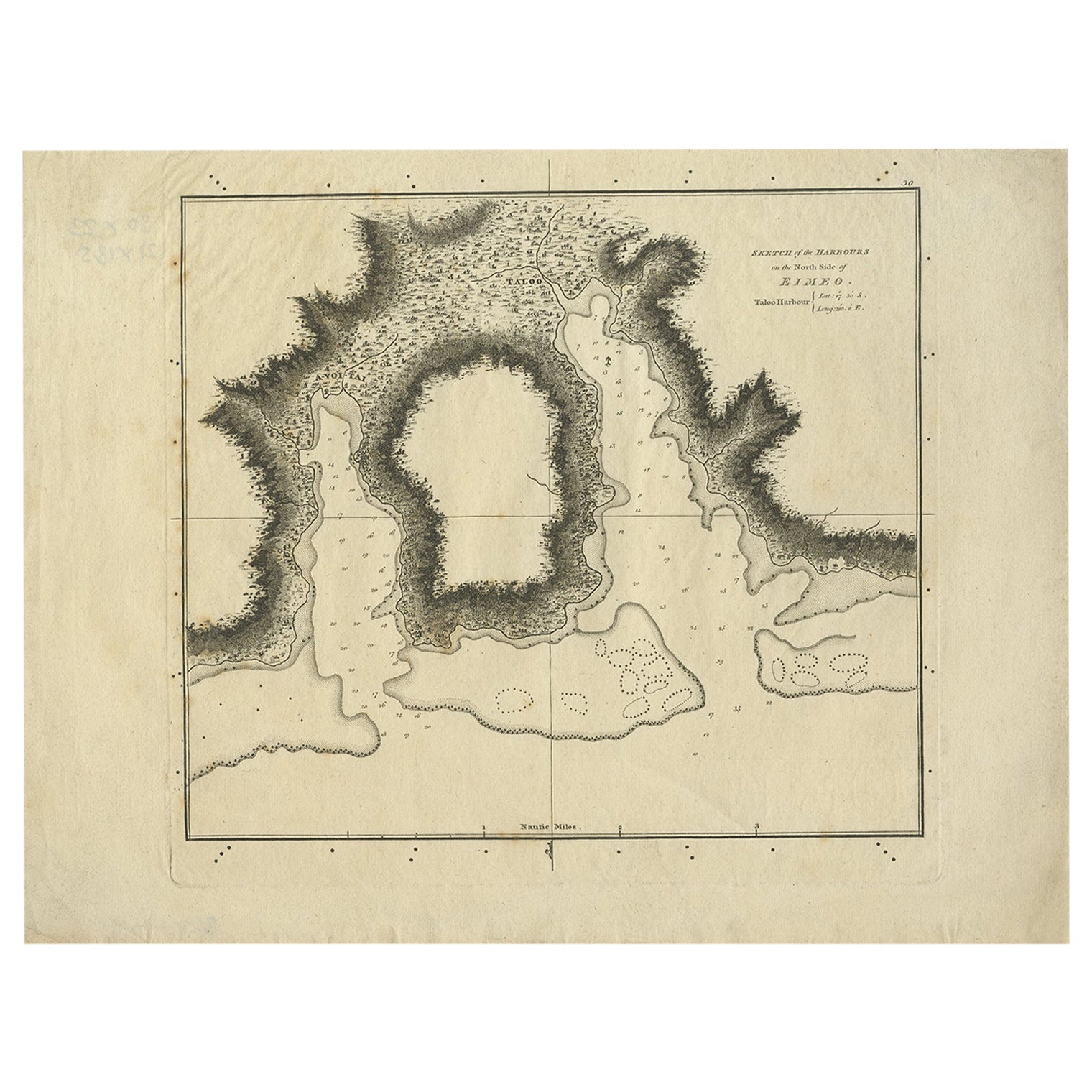
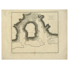
Antique Plan of the Harbour of Taloo by Cook, c.1781
$220.65
$275.8120% Off
£164.14
£205.1820% Off
€184
€23020% Off
CA$302.14
CA$377.6820% Off
A$335.94
A$419.9320% Off
CHF 175.41
CHF 219.2620% Off
MX$4,089.24
MX$5,111.5520% Off
NOK 2,238.17
NOK 2,797.7120% Off
SEK 2,097.05
SEK 2,621.3220% Off
DKK 1,400.69
DKK 1,750.8620% Off
Shipping
Retrieving quote...The 1stDibs Promise:
Authenticity Guarantee,
Money-Back Guarantee,
24-Hour Cancellation
About the Item
Antique map titled 'Sketch of the Harbours on the North Side of Eimeo (..)'. Plan of the harbour of Taloo in the Island of Moorea, one of the Society Islands, French Polynesia. Originates from an edition of Cook's Voyages.
Artists and Engravers: Engraved by Duff.
Condition: Good, some wear and age-related toning. Please study image carefully.
Date: c.1781
Overall size: 27.5 x 20.5 cm.
Image size: 21 x 18 cm.
We sell original antique maps to collectors, historians, educators and interior decorators all over the world. Our collection includes a wide range of authentic antique maps from the 16th to the 20th centuries. Buying and collecting antique maps is a tradition that goes back hundreds of years. Antique maps have proved a richly rewarding investment over the past decade, thanks to a growing appreciation of their unique historical appeal. Today the decorative qualities of antique maps are widely recognized by interior designers who appreciate their beauty and design flexibility. Depending on the individual map, presentation, and context, a rare or antique map can be modern, traditional, abstract, figurative, serious or whimsical. We offer a wide range of authentic antique maps for any budget.
- Dimensions:Height: 8.08 in (20.5 cm)Width: 10.83 in (27.5 cm)Depth: 0 in (0.01 mm)
- Materials and Techniques:
- Period:
- Date of Manufacture:c.1781
- Condition:Condition: Good, some wear and age-related toning. Please study image carefully.
- Seller Location:Langweer, NL
- Reference Number:Seller: BGJC-1881stDibs: LU3054329624892
About the Seller
5.0
Recognized Seller
These prestigious sellers are industry leaders and represent the highest echelon for item quality and design.
Platinum Seller
Premium sellers with a 4.7+ rating and 24-hour response times
Established in 2009
1stDibs seller since 2017
2,510 sales on 1stDibs
Typical response time: <1 hour
- ShippingRetrieving quote...Shipping from: Langweer, Netherlands
- Return Policy
Authenticity Guarantee
In the unlikely event there’s an issue with an item’s authenticity, contact us within 1 year for a full refund. DetailsMoney-Back Guarantee
If your item is not as described, is damaged in transit, or does not arrive, contact us within 7 days for a full refund. Details24-Hour Cancellation
You have a 24-hour grace period in which to reconsider your purchase, with no questions asked.Vetted Professional Sellers
Our world-class sellers must adhere to strict standards for service and quality, maintaining the integrity of our listings.Price-Match Guarantee
If you find that a seller listed the same item for a lower price elsewhere, we’ll match it.Trusted Global Delivery
Our best-in-class carrier network provides specialized shipping options worldwide, including custom delivery.More From This Seller
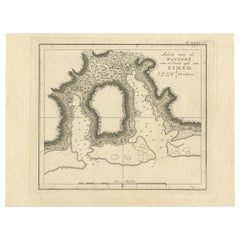
View AllAntique Plan of the Harbour of Taloo by Cook, 1784
Located in Langweer, NL
Antique map titled 'Sketch of the Harbours on the North Side of Eimeo (..)'. Plan of the harbour of Taloo in the Island of Moorea, one of the Society Islands, French Polynesia. Origi...
Category
Antique 18th Century Maps
Materials
Paper
$182 Sale Price
20% Off
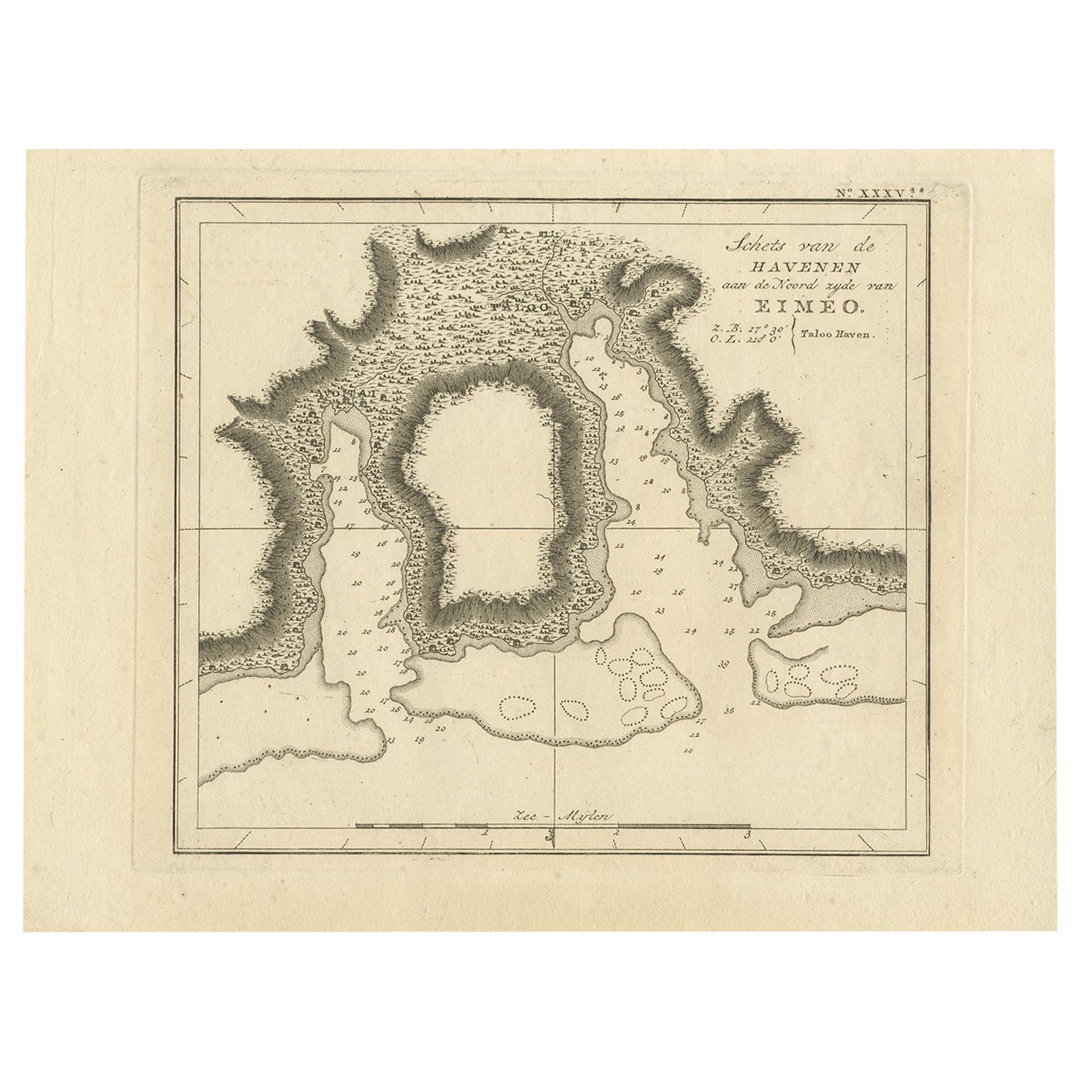
Antique Map of the Harbour of Taloo by J. Cook, 1803
By James Cook
Located in Langweer, NL
Antique map French Polynesia titled 'Schets van de Havenen aan de Noord Zijde van Eimeo'. Plan of the harbour of Taloo in the Island of Moorea, one of the Society Islands, French Polynesia. Originates from 'Reize rondom de Waereld door James Cook...
Category
Antique Early 19th Century Dutch Maps
Materials
Paper
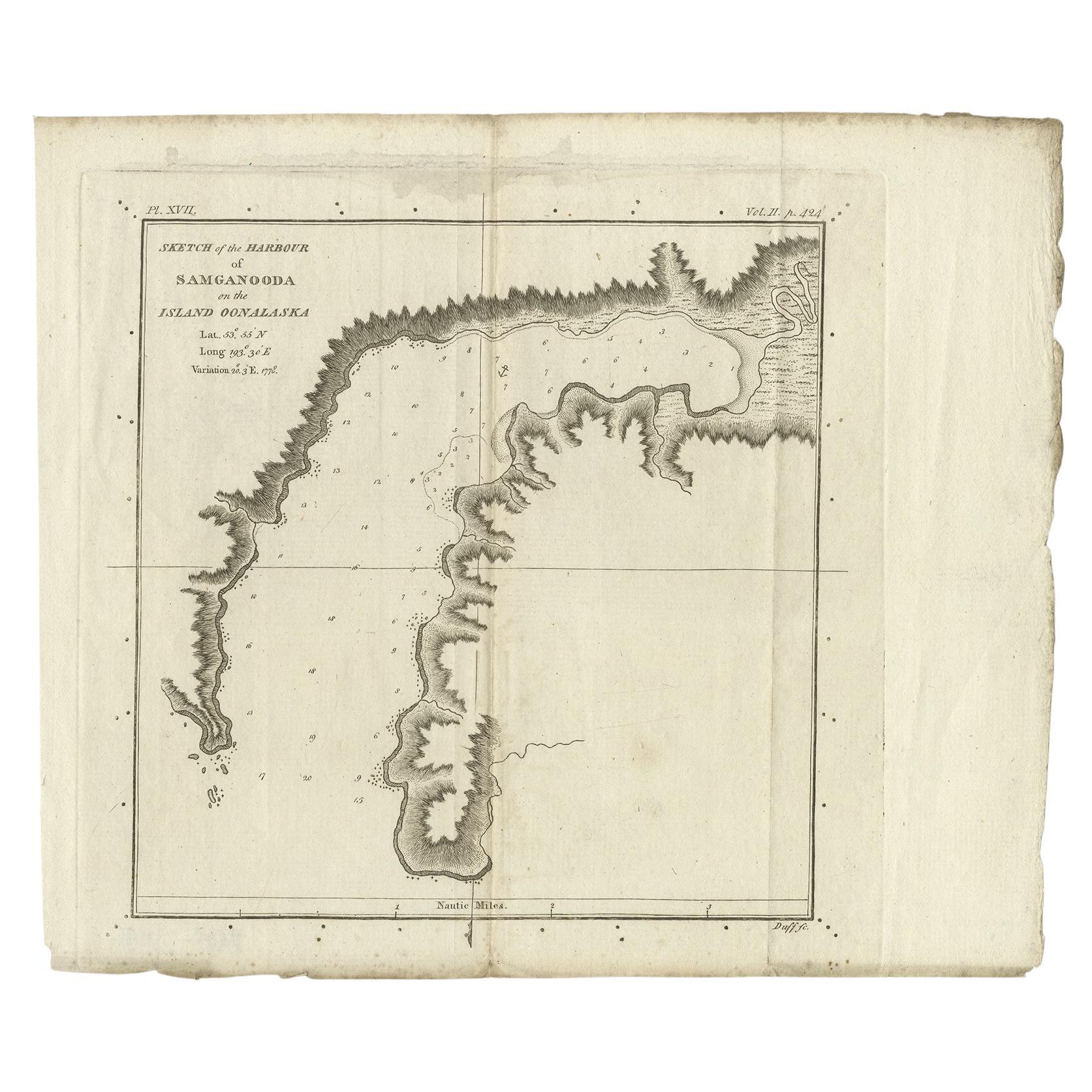
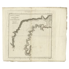
Antique Map of the Harbour of Samganoodha by Cook, c.1781
Located in Langweer, NL
Antique map titled 'Sketch of the Harbour of Samganooda (..)'. Antique map of the Harbour of Samganoodha, Oonalaska, North America. Originates from an edition of Cook's Voyages.
Art...
Category
Antique 18th Century Maps
Materials
Paper
$133 Sale Price
20% Off
Original Antique Map of the Harbour of Tongatabu by Cook, 1784
Located in Langweer, NL
Antique map titled 'Sketch of Tongataboo Harbour (..)'. Antique map of the harbour of Tongatabu, one of the Tonga Islands. Originates from an edition of Cook's Voyages.
Artists an...
Category
Antique 18th Century Maps
Materials
Paper

$422 Sale Price
20% Off
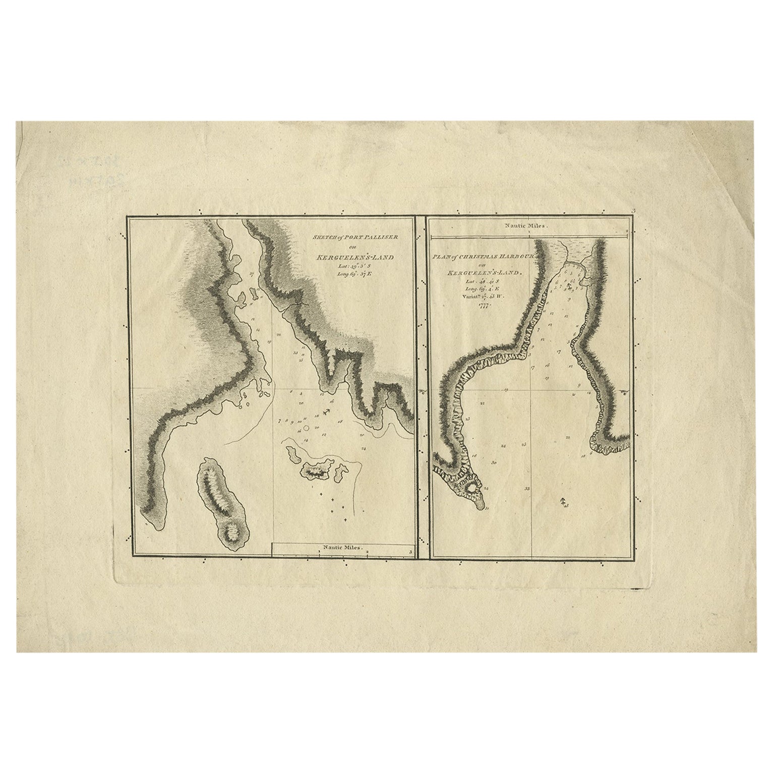
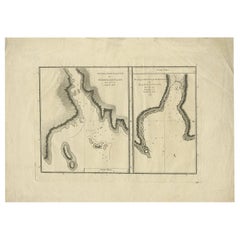
Antique Map of Port Pallisers & Kersmis by Cook, 1784
Located in Langweer, NL
Antique map Kerguelen titled 'Sketch of Port Palliser on Kerguelen's Land (..)'. Antique map of Port Pallisers & Kersmis, Kerguelen or Desolation Islands. Originates from an edition ...
Category
Antique 18th Century Maps
Materials
Paper
$211 Sale Price
20% Off
Antique Map of Port Pallisers & Kersmis by Cook, c.1781
Located in Langweer, NL
Antique map Kerguelen titled 'Sketch of Port Palliser on Kerguelen's Land (..)'. Antique map of Port Pallisers & Kersmis, Kerguelen or Desolation Islands. Originates from an edition ...
Category
Antique 18th Century Maps
Materials
Paper

$220 Sale Price
20% Off
You May Also Like
Plan of Port Siagi - Etching by Joseph Roux - 1795
Located in Roma, IT
Plan of Port Siagi is al colored etching realized by Joseph Roux in 1795.
The title at the top " Plan du Port Siagi"
Passepartout included: 34 x 49
The artwork is hand water-color...
Category
1790s Modern Figurative Prints
Materials
Etching

Dartmouth, England: A Hand-Colored 17th Century Sea Chart by Captain Collins
By Captain Greenvile Collins
Located in Alamo, CA
This hand-colored sea chart of the area around Dartmouth, England is from "Great Britain's Coasting Pilot. Being a New and Exact Survey of the Sea-Coast of England", first published ...
Category
Antique Late 17th Century English Maps
Materials
Paper

18th Century Map Engraving - Plan of the Works of the City of Messina, Sicily
Located in Corsham, GB
A map of Messina, a harbour city in northeast Sicily. Inscribed with the title in plate to the lower edge, 'Plan of the Works of the City of Messina, one of the strongest and most co...
Category
18th Century More Prints
Materials
Engraving

$285 Sale Price
20% Off
Original Antique Map or City Plan of Geneva, Switzerland. Circa 1835
Located in St Annes, Lancashire
Nice map of Geneva
Drawn and engraved by J.Dower
Published by Orr & Smith. C.1835
Unframed.
Free shipping
Category
Antique 1830s English Maps
Materials
Paper

Original Antique Map of Switzerland, Engraved By Barlow, Dated 1807
Located in St Annes, Lancashire
Great map of Switzerland
Copper-plate engraving by Barlow
Published by Brightly & Kinnersly, Bungay, Suffolk.
Dated 1807
Unframed.
Category
Antique Early 1800s English Maps
Materials
Paper

19th Century Reprint of 16th Century Harbor Map of Copenhagen
Located in Haddonfield, NJ
This reprint of 1587 antique map of Copenhagen, Denmark retains its original mid-century mat and has been recently reframed in classic wood frame. The muted sepia colored map is a wo...
Category
Antique 1880s Danish Baroque Maps
Materials
Wood, Paper

More Ways To Browse
Cook Islands
Mariners Chart
Papua New Guinea Antique Map
Bermuda Map
Scan Globe
Tunisia Antique Map
Antique Map New Orleans
Antique Maps Of Maryland
Gambia Antique Map
Antique Manitoba
Antique Map Of Brooklyn
Antique Map Of Michigan
Cham Antiques
Map Of Native American Tribes
Antique Furniture Halifax Furniture
Antique Furniture Trinidad
Antique Kiel Furniture
Cornwall Map