Items Similar to Beautiful 17th Century Map of Paris and Isle de France by Templeux, c.1650


Want more images or videos?
Request additional images or videos from the seller
1 of 10
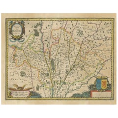
Beautiful 17th Century Map of Paris and Isle de France by Templeux, c.1650
$745.72
£562.41
€640
CA$1,031.03
A$1,154.92
CHF 606.61
MX$14,043.50
NOK 7,681.63
SEK 7,291.94
DKK 4,872.10
About the Item
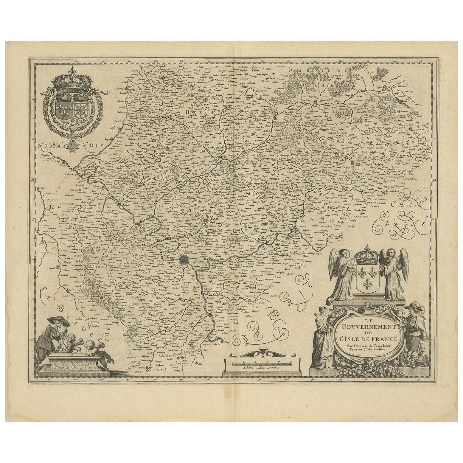
Map of Isle de France by D. de Templeux, ca. 1650, Hand-Colored and Decorative
This richly detailed antique map titled *Le Gouvernement de L'Isle de France* was engraved by Daniel de Templeux and published circa 1650. It provides an intricate view of the historic French province of Île-de-France—home to the city of Paris and the political heart of France from the medieval period through the early modern era. The map is a masterful example of mid-17th-century French cartography, hand-colored and printed on laid paper from a copperplate engraving.
Covering the Île-de-France region and parts of neighboring provinces such as Normandy, Champagne, Picardy, and Orléanais, the map shows an elaborate network of towns, rivers, and forests. Paris, the capital, is prominently marked in the center of the map. The geography is framed by a vibrant, decorative cartouche in the lower right, supported by angelic and allegorical figures, and a large royal coat of arms at the top left, celebrating the sovereignty and symbolism of the French monarchy.
Daniel de Templeux, a lesser-known but talented engraver, created this map for inclusion in composite atlases of French territories. His work stands out for its artistic embellishments and fine linework, characteristics highly prized by collectors today. The baroque visual language of this map—with putti, fruit garlands, and royal symbolism—makes it as much a work of art as a historical document.
This map captures a period of French history when Île-de-France was central to royal administration and military strategy, long before the revolutionary reorganization into modern départements. It appeals to anyone with a historical interest in Paris, royal France, or decorative cartography.
Condition Report:
Good condition. Original hand coloring still vivid. Light overall age toning (slightly browned), particularly near margins, consistent with age. Centerfold as issued, with no repairs. Paper remains stable.
Framing Tips:
This map deserves a fine frame—gilded, ebonized, or dark walnut wood—paired with a light beige or parchment-colored mat to draw attention to its soft tones and baroque flourishes. A museum-quality frame with UV-filtering glass will help preserve its colors and prevent further toning. Float mounting is an option to showcase the full plate and margins.
Keywords:
Isle de France antique map, Paris region map 1650, French royal map, Île-de-France map Templeux, 17th century map France, decorative baroque map, antique map of Paris, map with royal coat of arms, hand-colored French map, cartography of Louis XIV France, Daniel de Templeux engraver, early map of Paris region, collectible French provinces map, copper engraved Paris map, French monarchy cartographic history.
- Dimensions:Height: 18.9 in (48 cm)Width: 22.45 in (57 cm)Depth: 0.01 in (0.2 mm)
- Materials and Techniques:Paper,Engraved
- Period:1650-1659
- Date of Manufacture:circa 1650
- Condition:Good condition. Original hand coloring still vivid. Light overall age toning (slightly browned), particularly near margins, consistent with age. Centerfold as issued, with no repairs. Paper remains stable.
- Seller Location:Langweer, NL
- Reference Number:Seller: BG-14065-41stDibs: LU3054345049722
About the Seller
5.0
Recognized Seller
These prestigious sellers are industry leaders and represent the highest echelon for item quality and design.
Platinum Seller
Premium sellers with a 4.7+ rating and 24-hour response times
Established in 2009
1stDibs seller since 2017
2,517 sales on 1stDibs
Typical response time: <1 hour
- ShippingRetrieving quote...Shipping from: Langweer, Netherlands
- Return Policy
Authenticity Guarantee
In the unlikely event there’s an issue with an item’s authenticity, contact us within 1 year for a full refund. DetailsMoney-Back Guarantee
If your item is not as described, is damaged in transit, or does not arrive, contact us within 7 days for a full refund. Details24-Hour Cancellation
You have a 24-hour grace period in which to reconsider your purchase, with no questions asked.Vetted Professional Sellers
Our world-class sellers must adhere to strict standards for service and quality, maintaining the integrity of our listings.Price-Match Guarantee
If you find that a seller listed the same item for a lower price elsewhere, we’ll match it.Trusted Global Delivery
Our best-in-class carrier network provides specialized shipping options worldwide, including custom delivery.More From This Seller
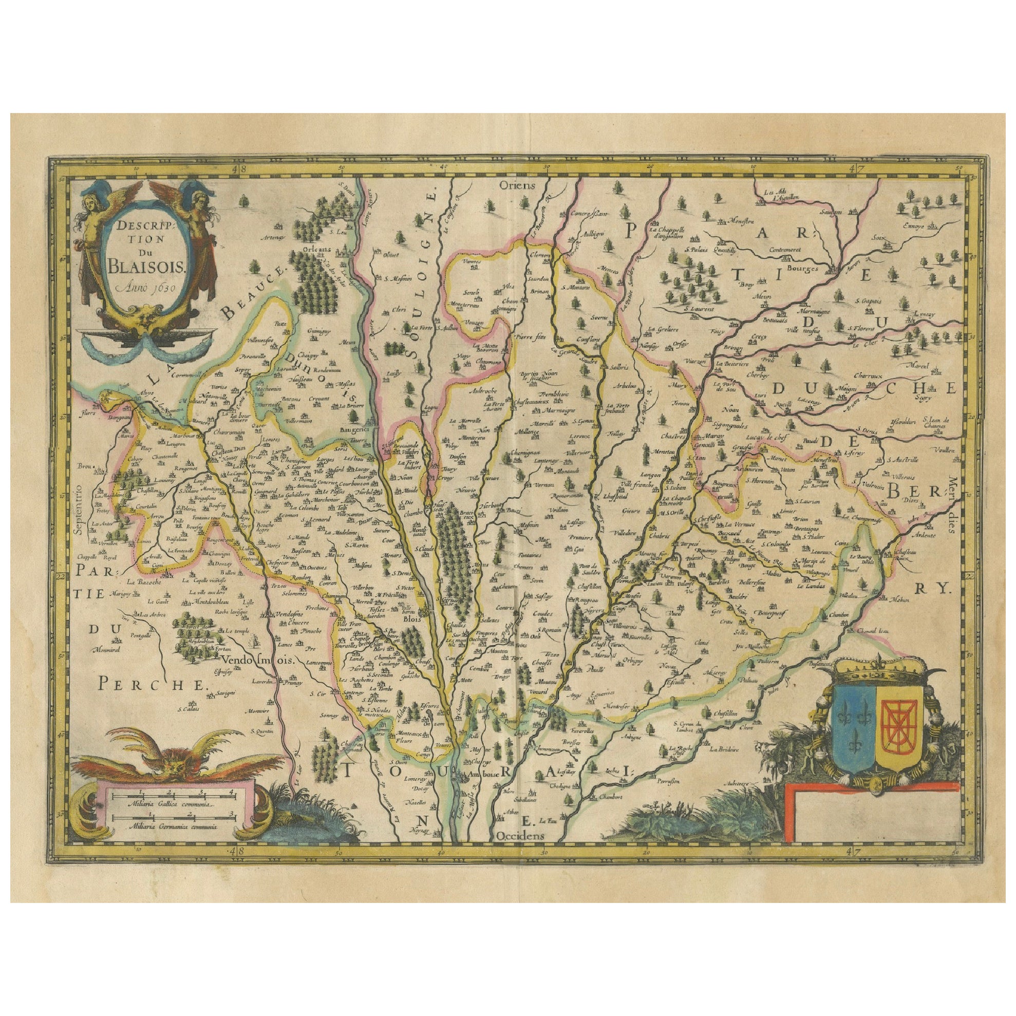
View AllMap of Blaisois by Janssonius, 1633, Decorative Antique Map of Loire Valley
Located in Langweer, NL
Map of Blaisois by Janssonius, 1633, Decorative Antique Map of Loire Valley
This finely detailed and colorfully embellished map titled 'Description du Blaisois' was published in 163...
Category
Antique 1630s Maps
Materials
Paper
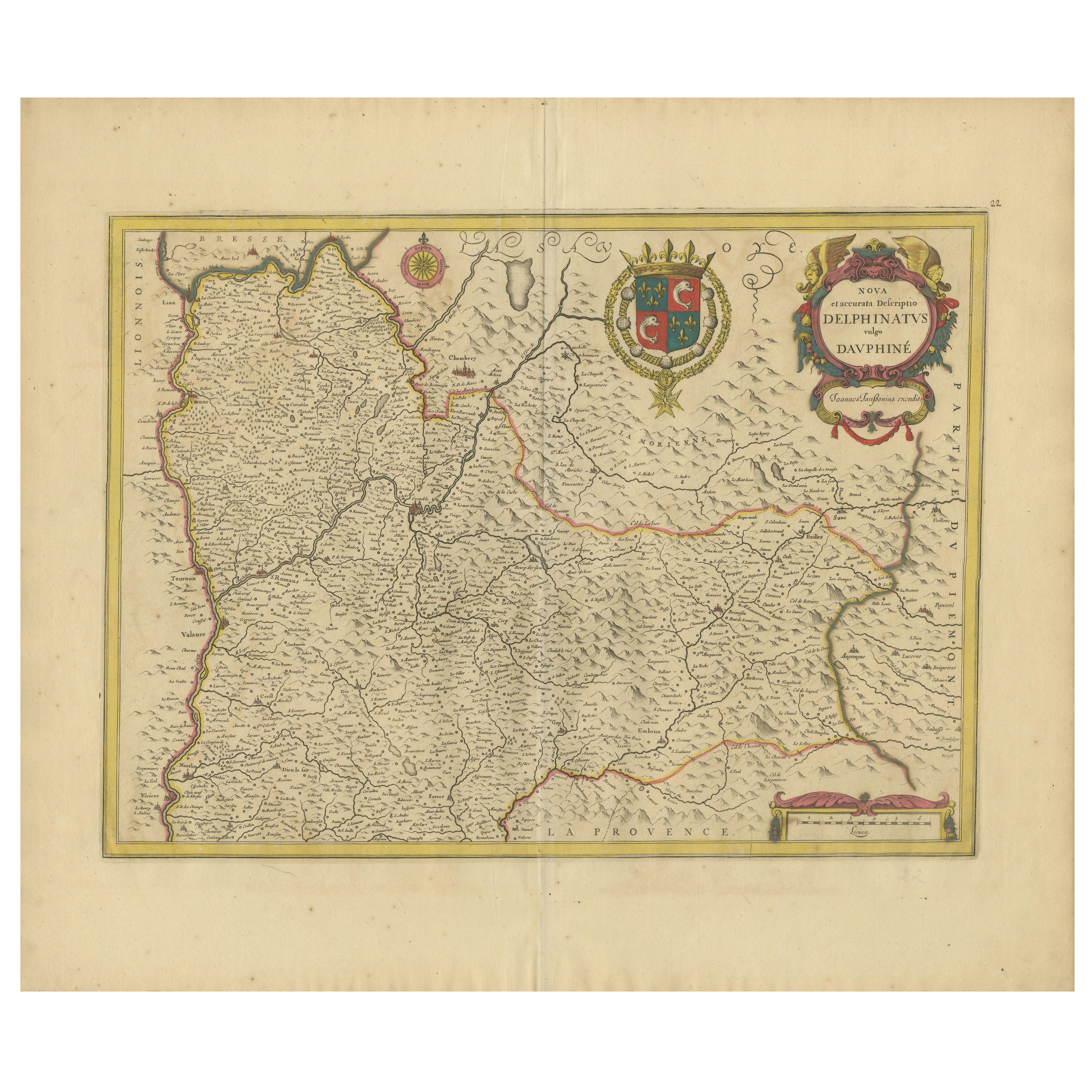
Rare 17th-Century Map of Dauphiné in Southeastern France by F. De Wit, ca.1688
Located in Langweer, NL
Title: Rare Hand-Colored 17th-Century Map of Dauphiné by Frederik De Wit c. 1688
Description: This captivating 17th-century map of Dauphiné, titled "Nova et Accurata Delphinatus Vul...
Category
Antique 1680s Maps
Materials
Paper

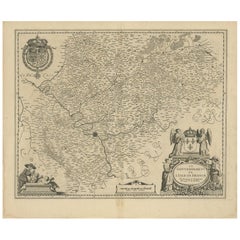
Antique Map of the Region of 'Île de France' by Janssonius, circa 1650
By Johannes Janssonius
Located in Langweer, NL
Antique map of France titled 'Le Gouvernement de L'Isle de France'. Paris is represented by a miniature plan of the city, making it distinct from the other towns of the region which ...
Category
Antique Mid-17th Century Maps
Materials
Paper
$419 Sale Price
20% Off
Antique Map of the Hainaut Region 'France' by F. de Wit, circa 1680
Located in Langweer, NL
Antique map titled 'Comitatus Hannoniae et Episcopatus Cambresis Descriptio'. Large map of the Hainaut region, France. Published by F. de Wit, circa 1680.
Category
Antique Late 17th Century Maps
Materials
Paper

$535 Sale Price
20% Off
Antique Map of the Region of Île-de-France by Hondius, circa 1630
Located in Langweer, NL
Antique map titled Gouvernement de l'Isle de France'. Old map of the region of Île-de-France, France. It is located in the north-central part of the country and often called the régi...
Category
Antique Mid-17th Century Maps
Materials
Paper

$512 Sale Price
20% Off
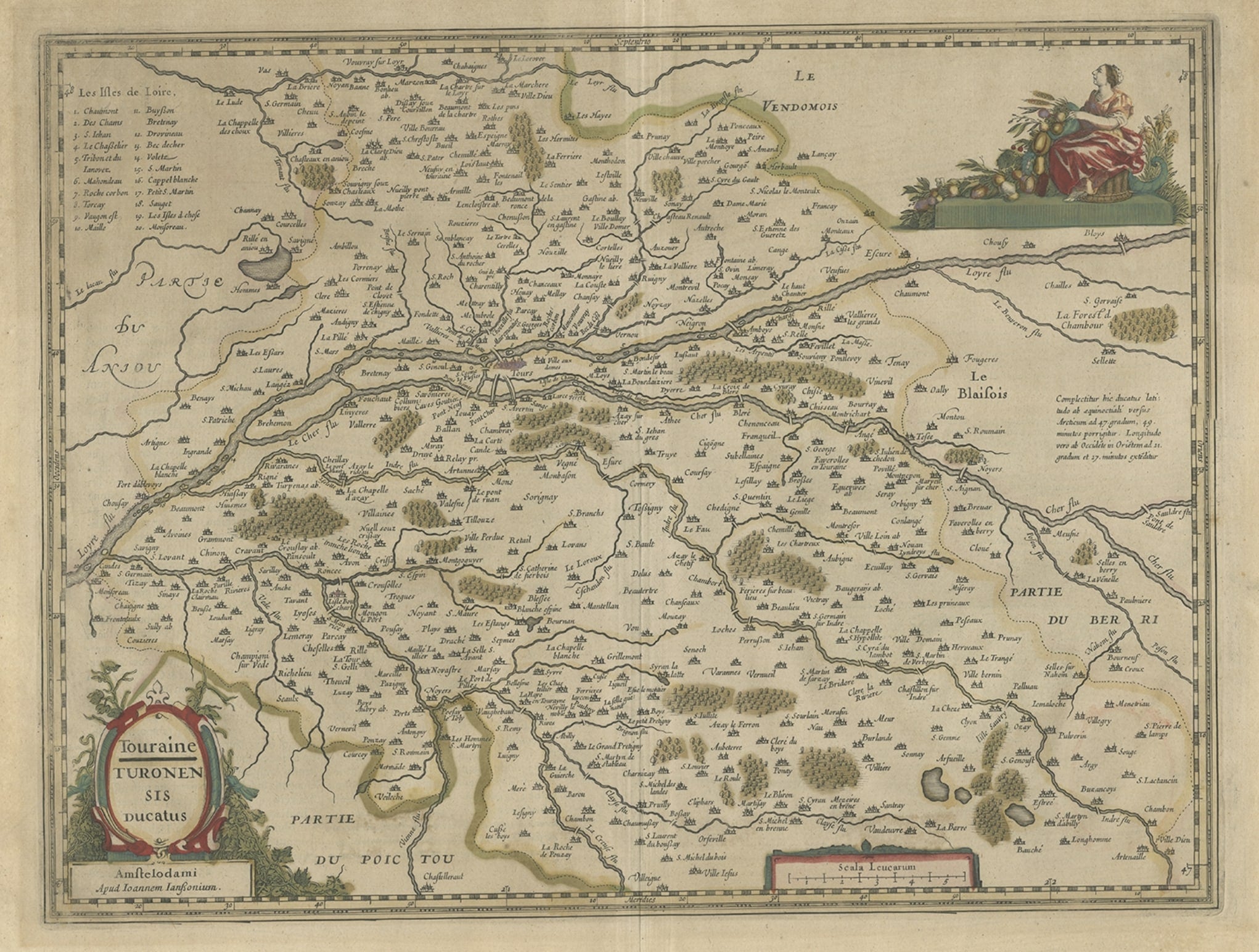
Antique Map of the Region of Touraine in France by Janssonius, 1657
By Johannes Janssonius
Located in Langweer, NL
Antique map titled 'Touraine - Turonensis Ducatus'.
Decorative map of the Touraine region. This map originates from 'Atlas Novus, Sive Theatrum Orbis Orbis Terrarum: In quo Galli...
Category
Antique 17th Century Maps
Materials
Paper
You May Also Like
1640 Joan Bleau Map Entitled"Diocecese de rheims et le pais de rethel, " Eic.a011
Located in Norton, MA
1640 Joan Bleau map entitled
"Diocecese de rheims et le pais de rethel,"
Ric.a011
OAN BLAEU
Diocecese de Rheims, et le pais de Rethel.
Handcolored engraving, c.1640.
...
Category
Antique 17th Century Dutch Maps
Materials
Paper

1635 Willem Blaeu Map of Northern France"Comitatvs Bellovacvm" Ric.a08
Located in Norton, MA
1635 Willem Blaeu map of northern France, entitled.
"Comitatvs Bellovacvm Vernacule Beavvais,"
Colored
Ric.a008
“COMITATVS BELLOVACVM…” Amsterdam: W...
Category
Antique 17th Century Unknown Maps
Materials
Paper

The Loire Valley of France: A 17th C. Hand-colored Map by Sanson and Jaillot
By Nicholas Sanson d'Abbeville
Located in Alamo, CA
This large 17th century copper plate hand-colored engraved map entitled "Gouvernement D'Orleans et la Generalite divisee en ses Elections Par...
Category
1690s Landscape Prints
Materials
Engraving

1630 Pierre Petit map "Description du Gouvernement de la Capelle" Ric0010
Located in Norton, MA
1630 Pierre Petit map entitled
"Description du Gouvernement de la Capelle,"
Ric0010
Pierre Petit was the son of a minor provincial official in Montluçon. The town, in the Auver...
Category
Antique 17th Century Dutch Maps
Materials
Paper

17th Century Hand-Colored Map of a Region in West Germany by Janssonius
By Johannes Janssonius
Located in Alamo, CA
This attractive highly detailed 17th century original hand-colored map is entitled "Archiepiscopatus Maghdeburgensis et Anhaltinus Ducatus cum terris adjacentibus". It was published ...
Category
Antique Mid-17th Century Dutch Maps
Materials
Paper

1656 Jansson Map Metz Region of France Entitled "Territorium Metense" Ric0014
Located in Norton, MA
1656 Jansson map Metz Region of France entitled "Territorium Metense."
Ric0014
" Authentic" - Map of the historical region surrounding Metz, in Lorraine, France.
Oriented with ...
Category
Antique 17th Century Dutch Maps
Materials
Paper
