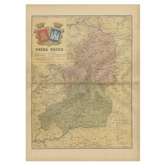
Items Similar to Beira Alta: A Cartographic Journey Through Portugal's Heartland in 1903

Want more images or videos?
Request additional images or videos from the seller
1 of 6
Beira Alta: A Cartographic Journey Through Portugal's Heartland in 1903
$278.21
$347.7620% Off
£206.96
£258.7020% Off
€232
€29020% Off
CA$380.96
CA$476.2020% Off
A$423.58
A$529.4820% Off
CHF 221.17
CHF 276.4620% Off
MX$5,156
MX$6,44520% Off
NOK 2,822.03
NOK 3,527.5420% Off
SEK 2,644.11
SEK 3,305.1420% Off
DKK 1,766.09
DKK 2,207.6120% Off
Shipping
Retrieving quote...The 1stDibs Promise:
Authenticity Guarantee,
Money-Back Guarantee,
24-Hour Cancellation
About the Item
The uploaded image is a historical map of the Beira Alta region in Portugal. The map is detailed, showing the topography, hydrography, and transportation networks of the region, including railroads and roads. Beira Alta is located in the central-northern part of Portugal and is known for its mountainous landscapes, historical villages, and the city of Viseu, which is featured on the coat of arms on the map.
Beira Alta is special for several reasons:
1. **Natural Beauty**: The region is part of the Serra da Estrela Natural Park, which includes the highest mountain range in mainland Portugal. It's known for its picturesque landscapes, hiking trails, and ski resorts.
2. **Historical Sites**: Beira Alta is rich in historical and cultural heritage, with several castles, Romanesque churches, and ancient monuments dotting the landscape.
3. **Wine Production**: The region is part of the Dão wine region, producing some of Portugal's most esteemed wines.
4. **Culinary Traditions**: Beira Alta has a strong culinary tradition with distinctive dishes like Serra da Estrela cheese, a variety of sausages, and hearty stews.
- Dimensions:Height: 14.77 in (37.5 cm)Width: 20.08 in (51 cm)Depth: 0 in (0.02 mm)
- Materials and Techniques:
- Period:1900-1909
- Date of Manufacture:1903
- Condition:Good condition. Central vertical folding lines as issued. Aged paper with typically warm, yellowish-brown hue, especially around the edges and folding lines, adding to its patina. Check the images carefully.
- Seller Location:Langweer, NL
- Reference Number:Seller: BG-13642-601stDibs: LU3054338034822
About the Seller
5.0
Recognized Seller
These prestigious sellers are industry leaders and represent the highest echelon for item quality and design.
Platinum Seller
Premium sellers with a 4.7+ rating and 24-hour response times
Established in 2009
1stDibs seller since 2017
2,510 sales on 1stDibs
Typical response time: <1 hour
- ShippingRetrieving quote...Shipping from: Langweer, Netherlands
- Return Policy
Authenticity Guarantee
In the unlikely event there’s an issue with an item’s authenticity, contact us within 1 year for a full refund. DetailsMoney-Back Guarantee
If your item is not as described, is damaged in transit, or does not arrive, contact us within 7 days for a full refund. Details24-Hour Cancellation
You have a 24-hour grace period in which to reconsider your purchase, with no questions asked.Vetted Professional Sellers
Our world-class sellers must adhere to strict standards for service and quality, maintaining the integrity of our listings.Price-Match Guarantee
If you find that a seller listed the same item for a lower price elsewhere, we’ll match it.Trusted Global Delivery
Our best-in-class carrier network provides specialized shipping options worldwide, including custom delivery.More From This Seller
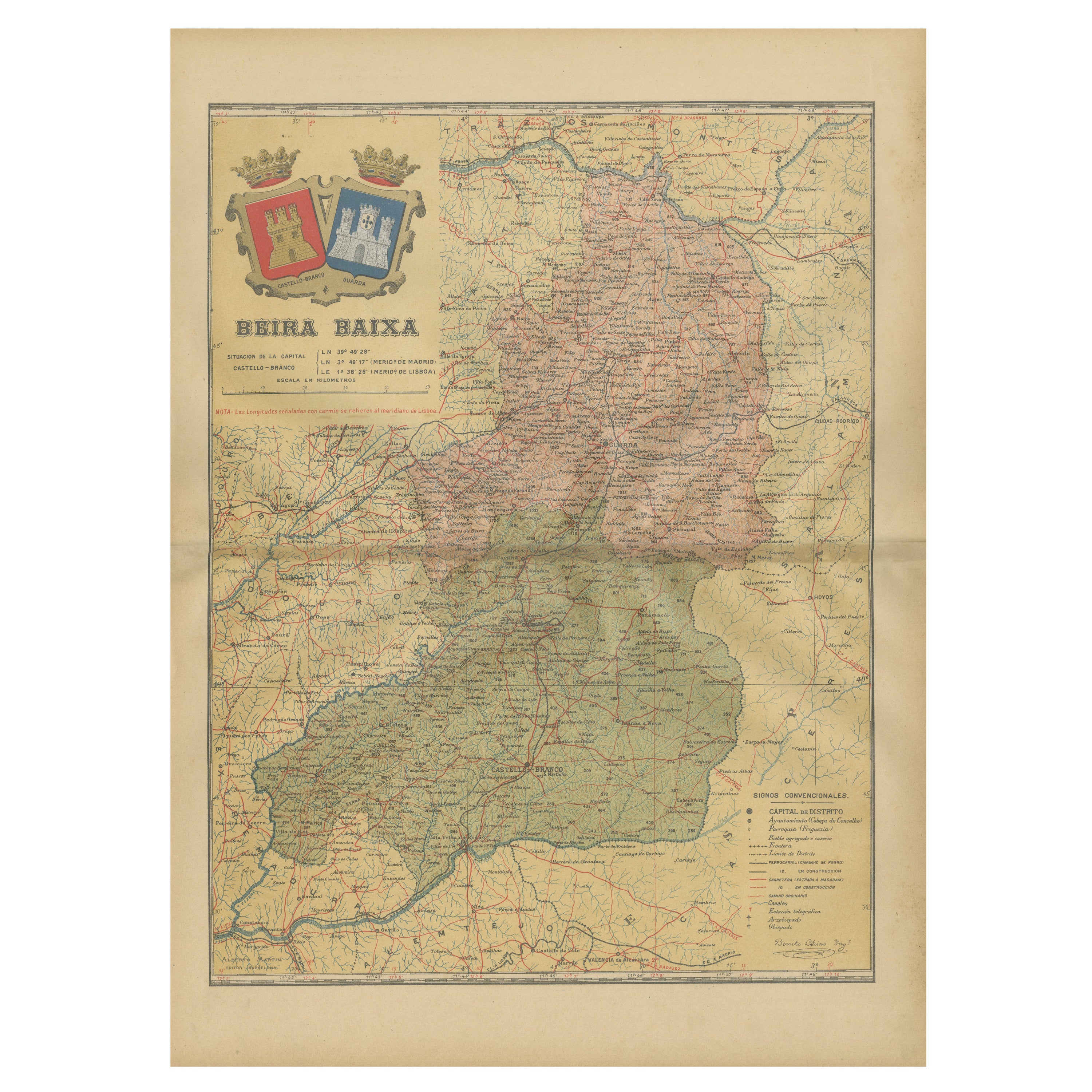
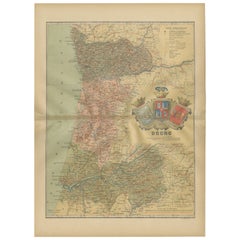
View AllBeira Baixa: A Cartographic Portrait of Portugal's Historic Frontier in 1903
Located in Langweer, NL
The uploaded image is a historical map of the Beira Baixa region in Portugal. The map details the topography, including mountain ranges and river systems, as well as the transportati...
Category
Antique Early 1900s Maps
Materials
Paper
$278 Sale Price
20% Off
Free Shipping
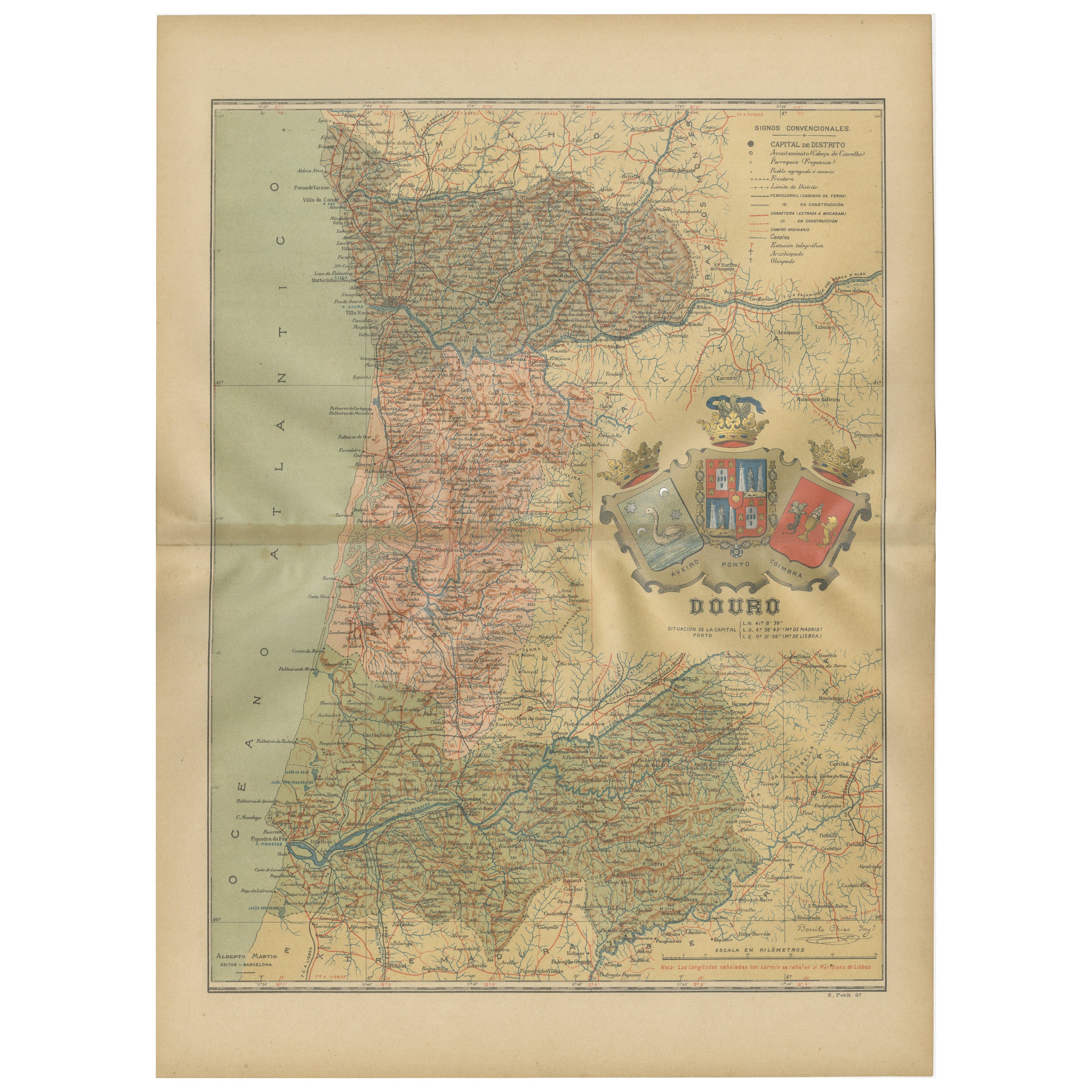
Douro: The River of Tradition and Wine in Portugal, 1903
Located in Langweer, NL
The uploaded image is a historical map of the Beira Baixa region in Portugal. The map details the topography, including mountain ranges and river systems, as well as the transportati...
Category
Antique Early 1900s Maps
Materials
Paper
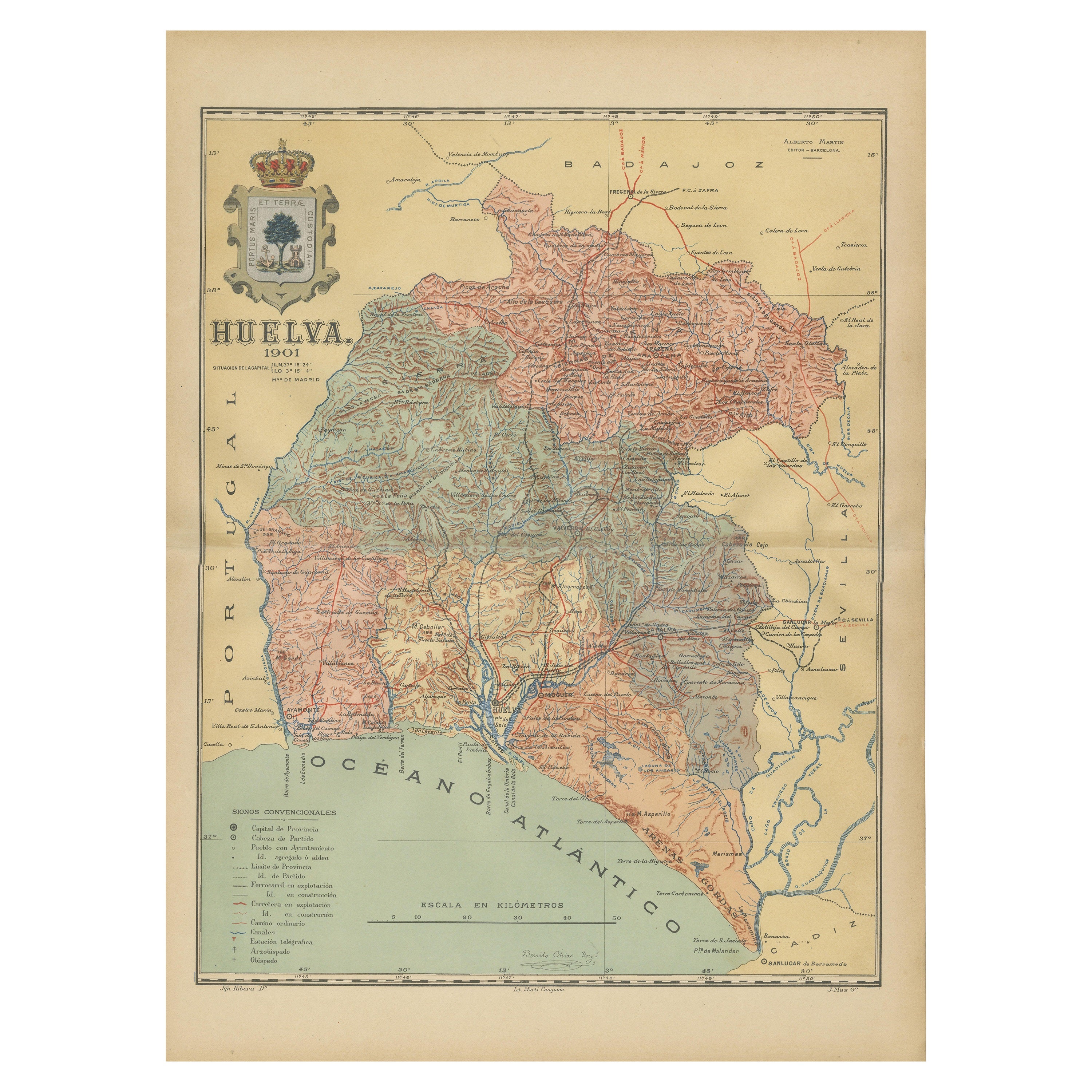
Huelva 1901: A Cartographic Presentation of Andalusia's Atlantic Frontier
Located in Langweer, NL
The map displays the province of Huelva, located in the southwestern part of the autonomous community of Andalusia in Spain, as of the year 1901. It outlines various geographic and m...
Category
Antique Early 1900s Maps
Materials
Paper

$345 Sale Price
20% Off
Free Shipping
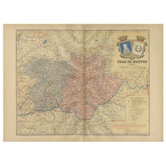
Trás-os-Montes: A Cartographic Exploration of Portugal's Hidden Province in 1903
Located in Langweer, NL
This print is an original historical map of the Trás-os-Montes region in the northeastern part of Portugal, dated 1903. Trás-os-Montes is often translated as "behind the mountains," ...
Category
Antique Early 1900s Maps
Materials
Paper
$297 Sale Price
20% Off
Free Shipping
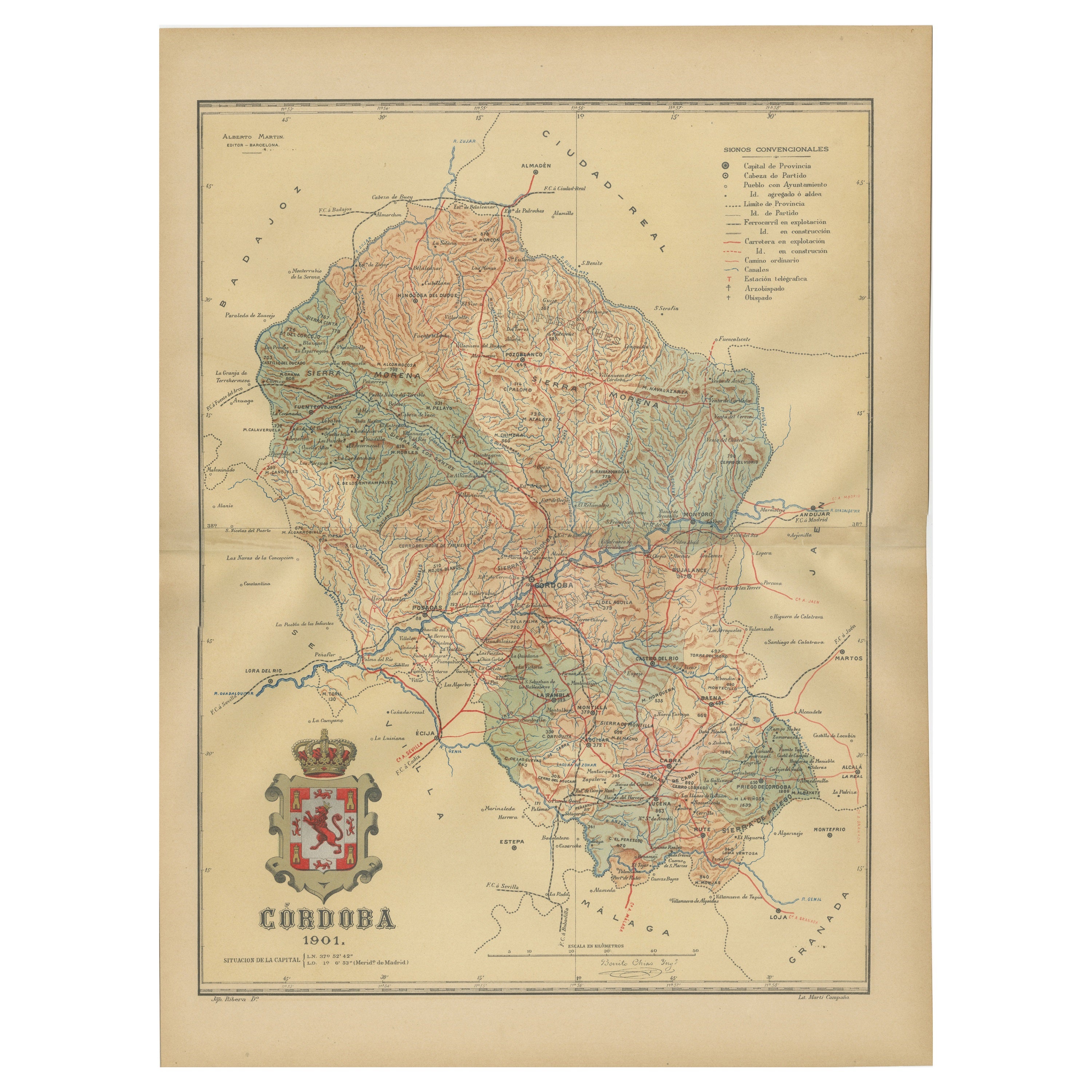
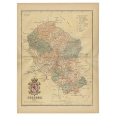
Córdoba 1901: A Cartographic Journey Through Andalusia’s Heartland in Spain
Located in Langweer, NL
The map provided is of the province of Córdoba, part of the autonomous community of Andalusia in southern Spain, as of the year 1901. It details various elements:
The map displays the varied terrain of Córdoba, including the Sierra Morena to the north and the beginning of the Subbaetic Range to the south. It shows blue lines indicating rivers, most likely including the Guadalquivir River, which runs through the province. Red lines represent the transportation network of roads and railways, detailing how the province is interconnected.
Symbols on the map mark the locations of cities, towns, and villages, with the capital city of Córdoba highlighted. Dotted lines suggest the borders of the province within the region of Andalusia. A legend (Signos Convencionales) details the symbols used for provincial capitals, roads, railways, and other features. A scale in kilometers is included to assist in measuring distances between points on the map.
The coat of arms of Córdoba is prominently featured, displaying a castle and a lion, which are common heraldic symbols with historical significance to the region.
About the province of Córdoba:
Córdoba is historically significant, known for its cultural heritage, particularly during the time when it was the capital of the Islamic Emirate and then Caliphate of Córdoba. This period left a lasting architectural mark, notably the Mezquita-Catedral (Mosque-Cathedral), which is a UNESCO World Heritage site. The province's geography is diverse, with fertile valleys in the Guadalquivir basin and extensive olive groves, making it one of the most important areas for olive oil production...
Category
Antique Early 1900s Maps
Materials
Paper
$326 Sale Price
20% Off
Free Shipping
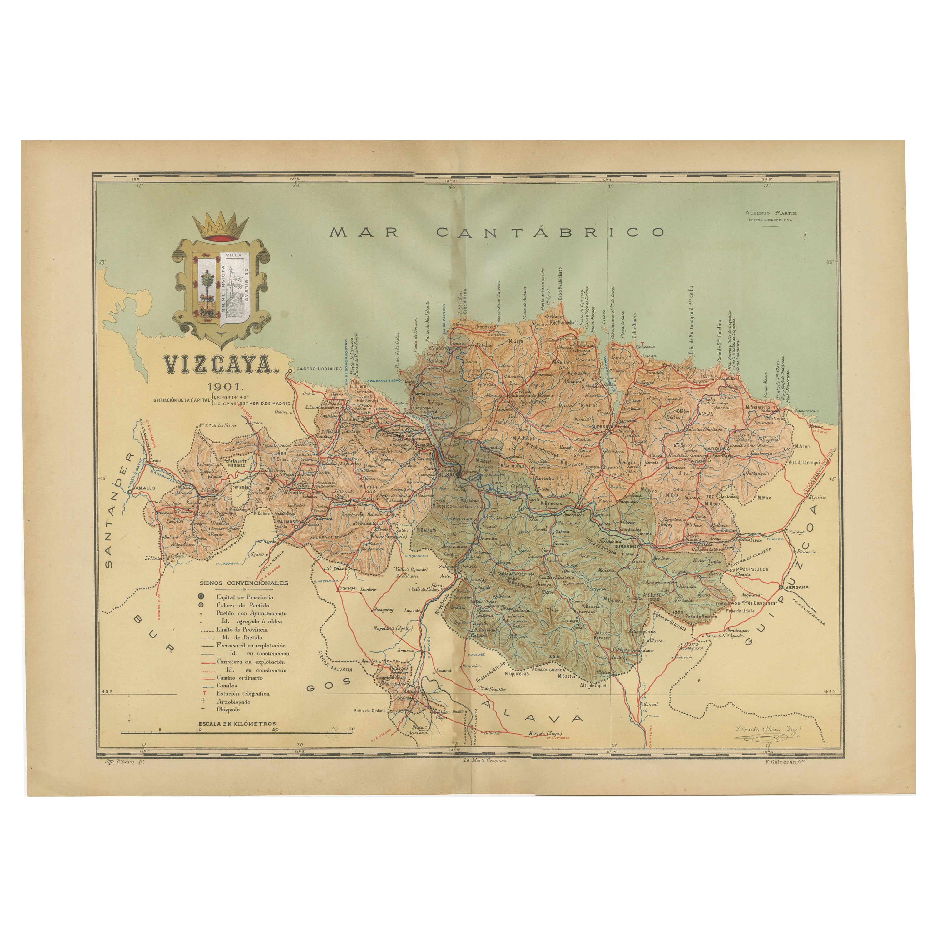
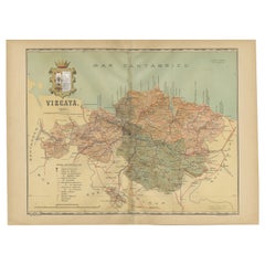
Cartographic Heritage: The 1901 Map of the Vizcaya Province in Spain
Located in Langweer, NL
This is a historical map of the province of Vizcaya (Biscay) in Spain, dated 1901. The title on the map is "VIZCAYA. 1901." It shows the topographical details of the region with cont...
Category
Antique Early 1900s Maps
Materials
Paper
$306 Sale Price
20% Off
Free Shipping
You May Also Like
Original Antique Map of Spain and Portugal, circa 1790
Located in St Annes, Lancashire
Super map of Spain and Portugal
Copper plate engraving by A. Bell
Published, circa 1790.
Unframed.
Category
Antique 1790s English Other Maps
Materials
Paper

Portugal: A Large 17th Century Hand-colored Map by Sanson and Jaillot
By Nicolas Sanson
Located in Alamo, CA
This large hand-colored map entitled "Le Royaume de Portugal et des Algarves Divisee en see Archeveches, Eveches et Territoires Par le Sr Sanson" was originally created by Nicholas S...
Category
Antique 1690s French Maps
Materials
Paper

Large Original Vintage Map of Spain, circa 1920
Located in St Annes, Lancashire
Great map of Spain
Original color.
Good condition
Published by Alexander Gross
Unframed.
Category
Vintage 1920s English Maps
Materials
Paper

South America, Eastern Part. Century Atlas antique vintage map
Located in Melbourne, Victoria
'The Century Atlas. South America. Eastern Part'
Original antique map, 1903.
Inset map 'Rio de Janeiro and Vicinity'.
Central fold as issued. Map name and number printed on the rev...
Category
Early 20th Century Victorian More Prints
Materials
Lithograph

Map of Spain and Portugal - Original Etching - Late 19th Century
Located in Roma, IT
This Map of Spain and Portugal is an etching realized by an anonymous artist.
The state of preservation of the artwork is good with some small diffused stains.
Sheet dimension: 28...
Category
Late 19th Century Modern Figurative Prints
Materials
Etching

After Johann B. Homann (1664-1724) - 19th C, General Map of Spain and Portugal
Located in Corsham, GB
General map of Spain and Portugal divided into its current provinces by D.T. Lopez, newly drawn by F. L. G. in Nuremberg at the Heret of Homann, 1782. A double-page engraved map with...
Category
19th Century More Prints
Materials
Engraving

More Ways To Browse
Early American Chairs
Hans Muller
Vintage Wood Table With Glass Top
19th Century Square Table
Antonio Bonet
Galle Chairs
Large Chinese Rug
1940s Vintage French Art Deco
20th Century Spanish Table
Antonio Bellini
Retro Fiberglass Furniture
Shipping Crate
Antique Oushak Carpets
Blue Coffee Tables
German Bauhaus Posters
1945 Chair Juhl
Antique Three Leg Table
Folke Arstrom