Items Similar to Beira Baixa: A Cartographic Portrait of Portugal's Historic Frontier in 1903


Want more images or videos?
Request additional images or videos from the seller
1 of 6
Beira Baixa: A Cartographic Portrait of Portugal's Historic Frontier in 1903
About the Item
The uploaded image is a historical map of the Beira Baixa region in Portugal. The map details the topography, including mountain ranges and river systems, as well as the transportation networks with roads and railways. Beira Baixa is known for its historical towns, natural beauty, and significant cultural heritage.
Beira Baixa is special for several reasons:
1. **Natural Landscapes**: The region is characterized by its diverse landscapes, from the Serra da Estrela mountain range to the Tagus river basin.
2. **Historical Towns**: Beira Baixa hosts several historical towns and villages, with castles, Roman ruins, and archaeological sites.
3. **Geopark Naturtejo**: This UNESCO Global Geopark highlights the geological diversity and natural beauty of the region, including the Ichnological Park of Penha Garcia with its ancient fossil trails.
4. **Cultural Festivals**: The region has rich folk traditions, with various festivals and fairs throughout the year that celebrate local culture, history, and cuisine.
5. **Handicrafts**: Beira Baixa is known for its traditional handicrafts, especially lace and embroidery, which have been passed down through generations.
- Dimensions:Height: 20.08 in (51 cm)Width: 14.77 in (37.5 cm)Depth: 0 in (0.02 mm)
- Materials and Techniques:
- Period:1900-1909
- Date of Manufacture:1903
- Condition:Good condition. Central vertical folding lines as issued. Aged paper with typically warm, yellowish-brown hue, especially around the edges and folding lines, adding to its patina. Check the images carefully.
- Seller Location:Langweer, NL
- Reference Number:
About the Seller
5.0
Platinum Seller
These expertly vetted sellers are 1stDibs' most experienced sellers and are rated highest by our customers.
Established in 2009
1stDibs seller since 2017
1,922 sales on 1stDibs
Typical response time: <1 hour
- ShippingRetrieving quote...Ships From: Langweer, Netherlands
- Return PolicyA return for this item may be initiated within 14 days of delivery.
More From This SellerView All
- Beira Alta: A Cartographic Journey Through Portugal's Heartland in 1903Located in Langweer, NLThe uploaded image is a historical map of the Beira Alta region in Portugal. The map is detailed, showing the topography, hydrography, and transportation networks of the region, incl...Category
Antique Early 1900s Maps
MaterialsPaper
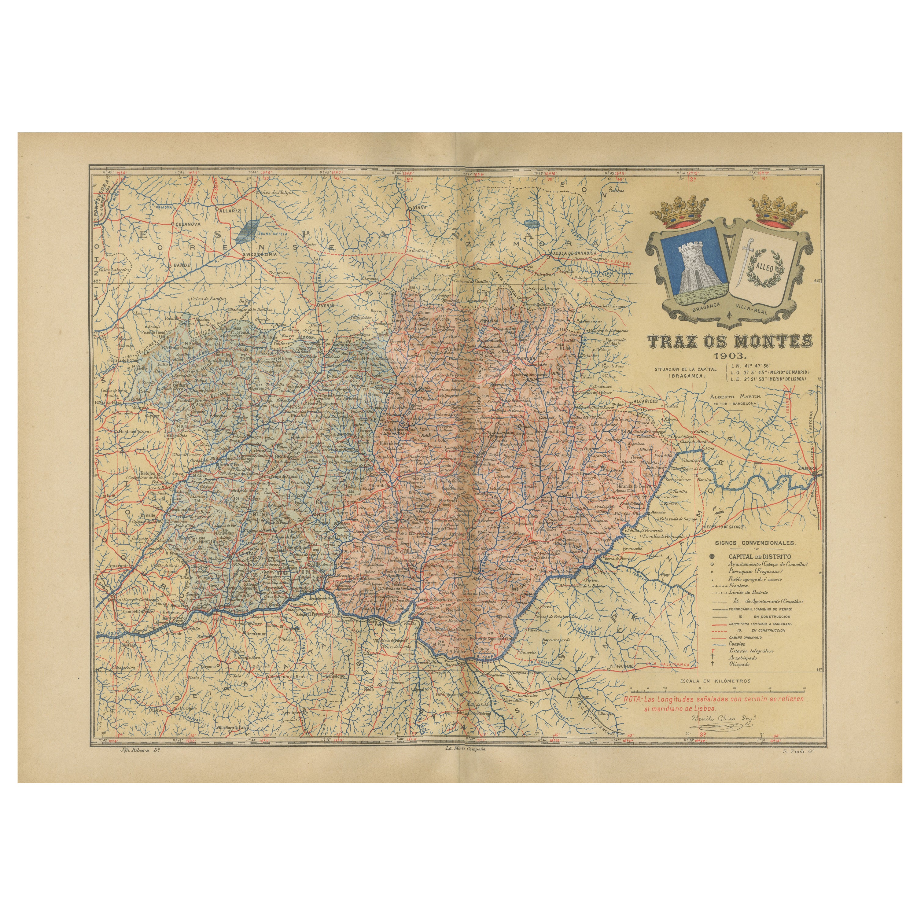
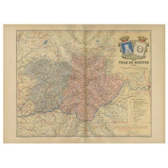
- Trás-os-Montes: A Cartographic Exploration of Portugal's Hidden Province in 1903Located in Langweer, NLThis print is an original historical map of the Trás-os-Montes region in the northeastern part of Portugal, dated 1903. Trás-os-Montes is often translated as "behind the mountains," ...Category
Antique Early 1900s Maps
MaterialsPaper
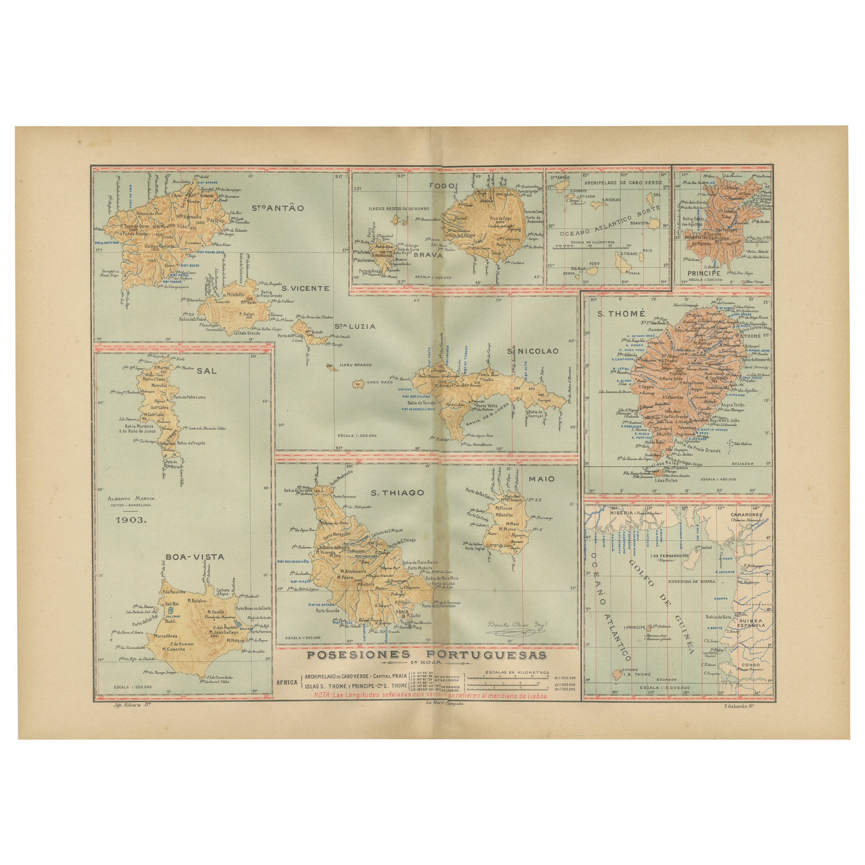
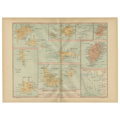
- Islands of Diversity: Portugal's Atlantic Archipelagos in 1903Located in Langweer, NLThe image is an original historical map from 1903 depicting Portuguese possessions in the Atlantic Ocean, specifically the islands of Cape Verde and the islands of São Tomé and Prínc...Category
Antique Early 1900s Maps
MaterialsPaper
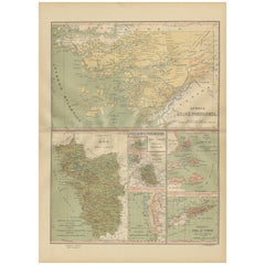
- Empire's Tapestry: Mapping Portugal's Global Legacy in 1903Located in Langweer, NLThis map is an original antique map that showcases Portuguese possessions around the turn of the 20th century, with a focus on Guinea-Bissau (referred to on the map as "Guiné Portugu...Category
Antique Early 1900s Maps
MaterialsPaper
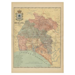
- Huelva 1901: A Cartographic Presentation of Andalusia's Atlantic FrontierLocated in Langweer, NLThe map displays the province of Huelva, located in the southwestern part of the autonomous community of Andalusia in Spain, as of the year 1901. It outlines various geographic and m...Category
Antique Early 1900s Maps
MaterialsPaper
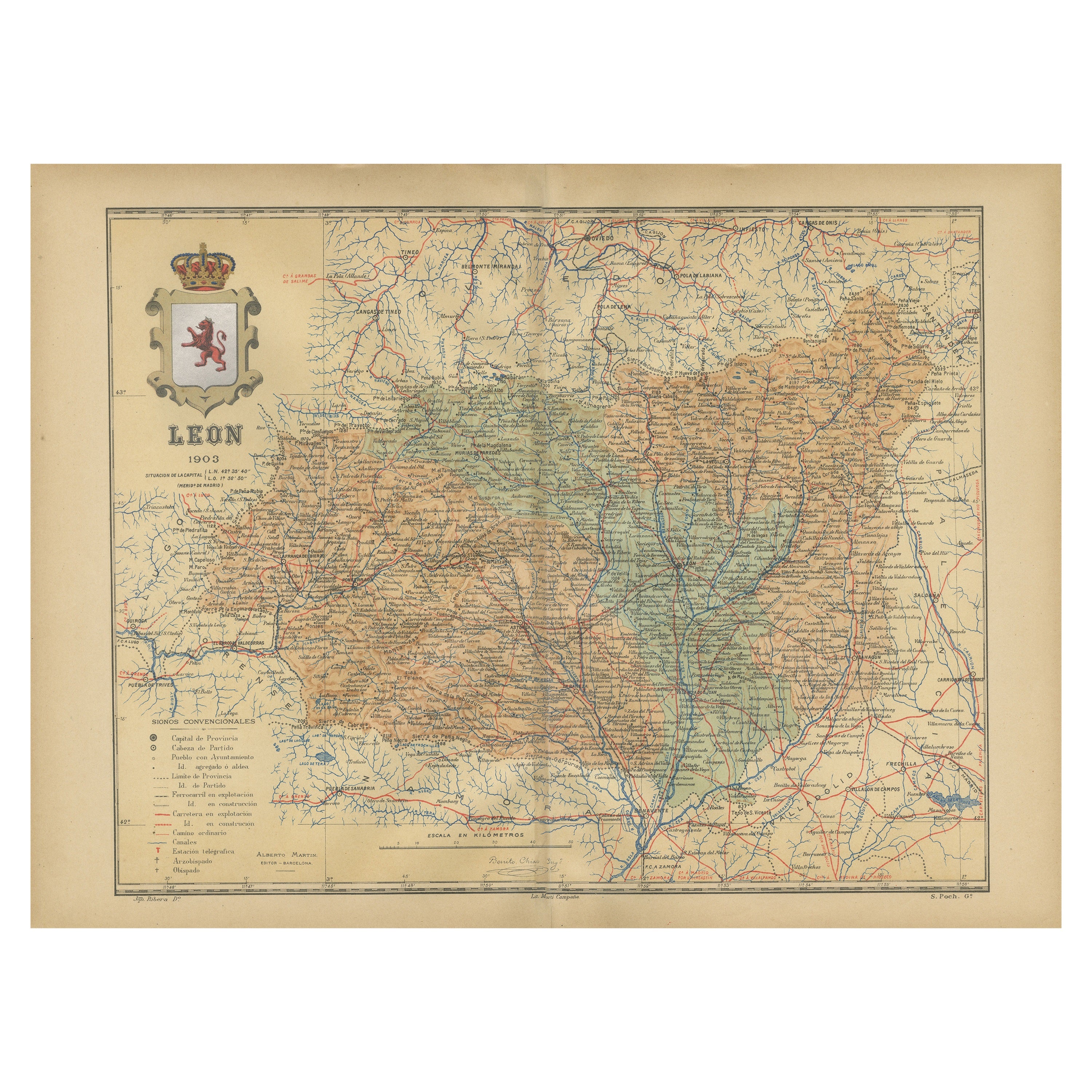
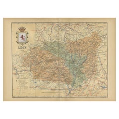
- León 1903: A Cartographic Detailing of Castilla y León's Mountainous ProvinceLocated in Langweer, NLThe map depicts the province of León, which is located in the northwest of Spain and forms part of the autonomous community of Castilla y León, as of 1903. Notable features of the ma...Category
Antique Early 1900s Maps
MaterialsPaper
You May Also Like
- Antique Folding London Map, English, Cartography, Historic, Georgian, Dated 1783Located in Hele, Devon, GBThis is an antique folding London map. An English, paper on linen cartographical study of the London metropolis and the surrounding area, published in the mid Georgian period, dated ...Category
Antique Late 18th Century British Georgian Maps
MaterialsLinen, Paper
- Historic Deerfield, A Portrait of Early America, First EditionBy Elizabeth StillingerLocated in valatie, NYHistoric Deerfield, A Portrait of Early America. New York: Dutton Studio Books, 1992. First edition hardcover with dust jacket. 206 pp. A book on historic Deerfield Massachusetts. The town was founded in 1669 by prosperous farmers who lined the mile long main street with architecturally significant houses. A lot of these house are now museums filled with American paintings, furniture, silver, and ceramics. The describes the rescue and restoration of Deerfield village building by building. Buildings include: The Allen House...Category
20th Century American Books
MaterialsPaper
- Sun and Moon a Story of Astronomy, Photography and CartographyLocated in New York City, NYA unique pictorial history of astronomical exploration from the earliest Prehistoric observatories to the latest satellite images with 280 spectacular images and an inspiring story i...Category
21st Century and Contemporary European Books
MaterialsPaper
- Antique Lithography Map of Cheshire, English, Framed, Cartography, VictorianLocated in Hele, Devon, GBThis is an antique lithography map of Cheshire. An English, framed atlas engraving of cartographic interest, dating to the mid 19th century and lat...Category
Antique Mid-19th Century British Victorian Maps
MaterialsWood
- Soapy Smith: King of the Frontier Con Men BookLocated in Seguin, TXSoapy Smith: King of the Frontier Con Men by Frank C. Robertson and Beth Kay Harris. Published by Hastings House, New York, 1961. 1880's con man working from Denver to Skagway. Re...Category
Mid-20th Century American Rustic Books
MaterialsPaper
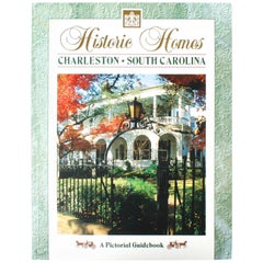
- Historic Homes of Charleston, South CarolinaLocated in valatie, NYHistorical Homes of Charleston, South Carolina. Charleston: Terrel Publishing Company, 1993. Soft cover. 95 pp. A beautiful pictorial guidebook to the historic homes of Charleston. The book includes homes on South Battery, Murry Blvd., Church St., Legare St., Tradd St., Meeting St., Broad St., Charleston, Rutledge Ave., King St., East Battery and East Bay. Charleston was founded in 1670 and is the oldest city between Virginia and Florida. The ''Grand Modell'' was the design of the "New Charles Town'' which was named after King Charles I of England...Category
20th Century American Books
MaterialsPaper


Recently Viewed
View AllMore Ways To Browse
La Syrie Antique
Laos Antique Map
Moravia Map
Nova Totius
Antique Indiana Map
Antique Map Delaware
Antique Maps Rhode Island
Antique Map Of North And East Asia 1751
Republic Of Texas Map
Vintage Road Maps Collectables
Astrological Map
Astrology Map
Atlas Indu
English County Maps By Blaeu
Kiels Antiques
Mauritius Antique Map
Old Cypriot Maps
Tanzania Antique Map