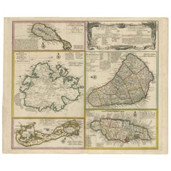
Items Similar to British Island Group Map 1695 – Morden’s Smaller Islands of the British Ocean

Want more images or videos?
Request additional images or videos from the seller
1 of 10
British Island Group Map 1695 – Morden’s Smaller Islands of the British Ocean
$400.96
£300.13
€340
CA$551.84
A$615.09
CHF 322.71
MX$7,511.19
NOK 4,086.26
SEK 3,862.14
DKK 2,588.32
About the Item
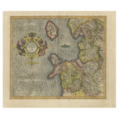
British Island Group Map 1695 – Morden’s Smaller Islands of the British Ocean
This rare and decorative late 17th-century map titled "The Smaller Islands in the British Ocean" was engraved by renowned English cartographer Robert Morden and published in London around 1695. The sheet presents a beautifully detailed cartographic overview of various smaller but historically significant British islands, meticulously divided into eight regional inset maps.
Centered prominently is the Isle of Wight, with its rivers, settlements, and natural features clearly labeled. Surrounding this are finely engraved panels showing the Isle of Man, the Scilly Isles, Jersey (labeled IERSEY or CÆSAREY), Guernsey (GARNSEY or SARINA), Alderney, Holy Island, and the Farne Islands. Each inset features its own scale and highly readable hand coloring applied to regional boundaries, settlements, and topographic elements.
Morden’s ornate title cartouche, elaborately decorated with classical scrollwork, anchors the map visually. This cartouche and the overall design reflect the late Baroque style popular in English cartography at the time. Despite their small size relative to Great Britain, these islands were politically, economically, and strategically important, and Morden’s decision to focus on them as a set marks this map as a unique and insightful document of English maritime geography.
Robert Morden (c.1650–1703) was a prolific mapmaker and globe manufacturer based in London. He is best known for his county maps of England and Wales, often included in Camden’s Britannia, as well as his participation in early atlases and geographical treatises. This map demonstrates both his technical skill and his eye for elegantly presenting detailed regional information.
Condition summary:
The map is in fair to good condition with original hand color. The paper remains strong with generous margins. A centerfold is visible as issued, with a few small professional repairs and minor toning at the edges, hardly affecting the image area. The print retains a deep impression with fine plate detail. A few wrinkles.
Framing suggestions:
A dark wood or ebonized frame with a double mat—cream with a red or olive inner accent—would enhance both the decorative cartouche and the rich original coloring. This map is a superb choice for collectors of English cartography, coastal studies, or historical maritime geography. Its blend of charm, history, and rarity makes it an excellent conversation piece for both traditional and eclectic interiors.
- Dimensions:Height: 15.4 in (39.1 cm)Width: 17.92 in (45.5 cm)Depth: 0.01 in (0.2 mm)
- Materials and Techniques:Paper,Engraved
- Place of Origin:
- Period:Late 17th Century
- Date of Manufacture:1695
- Condition:The map is in fair condition with original hand color. The paper remains strong with generous margins. A centerfold is visible as issued, with a few small professional repairs and minor toning at the edges, hardly affecting the image area.
- Seller Location:Langweer, NL
- Reference Number:Seller: BG-13757-91stDibs: LU3054345460292
About the Seller
5.0
Recognized Seller
These prestigious sellers are industry leaders and represent the highest echelon for item quality and design.
Platinum Seller
Premium sellers with a 4.7+ rating and 24-hour response times
Established in 2009
1stDibs seller since 2017
2,517 sales on 1stDibs
Typical response time: <1 hour
- ShippingRetrieving quote...Shipping from: Langweer, Netherlands
- Return Policy
Authenticity Guarantee
In the unlikely event there’s an issue with an item’s authenticity, contact us within 1 year for a full refund. DetailsMoney-Back Guarantee
If your item is not as described, is damaged in transit, or does not arrive, contact us within 7 days for a full refund. Details24-Hour Cancellation
You have a 24-hour grace period in which to reconsider your purchase, with no questions asked.Vetted Professional Sellers
Our world-class sellers must adhere to strict standards for service and quality, maintaining the integrity of our listings.Price-Match Guarantee
If you find that a seller listed the same item for a lower price elsewhere, we’ll match it.Trusted Global Delivery
Our best-in-class carrier network provides specialized shipping options worldwide, including custom delivery.More From This Seller
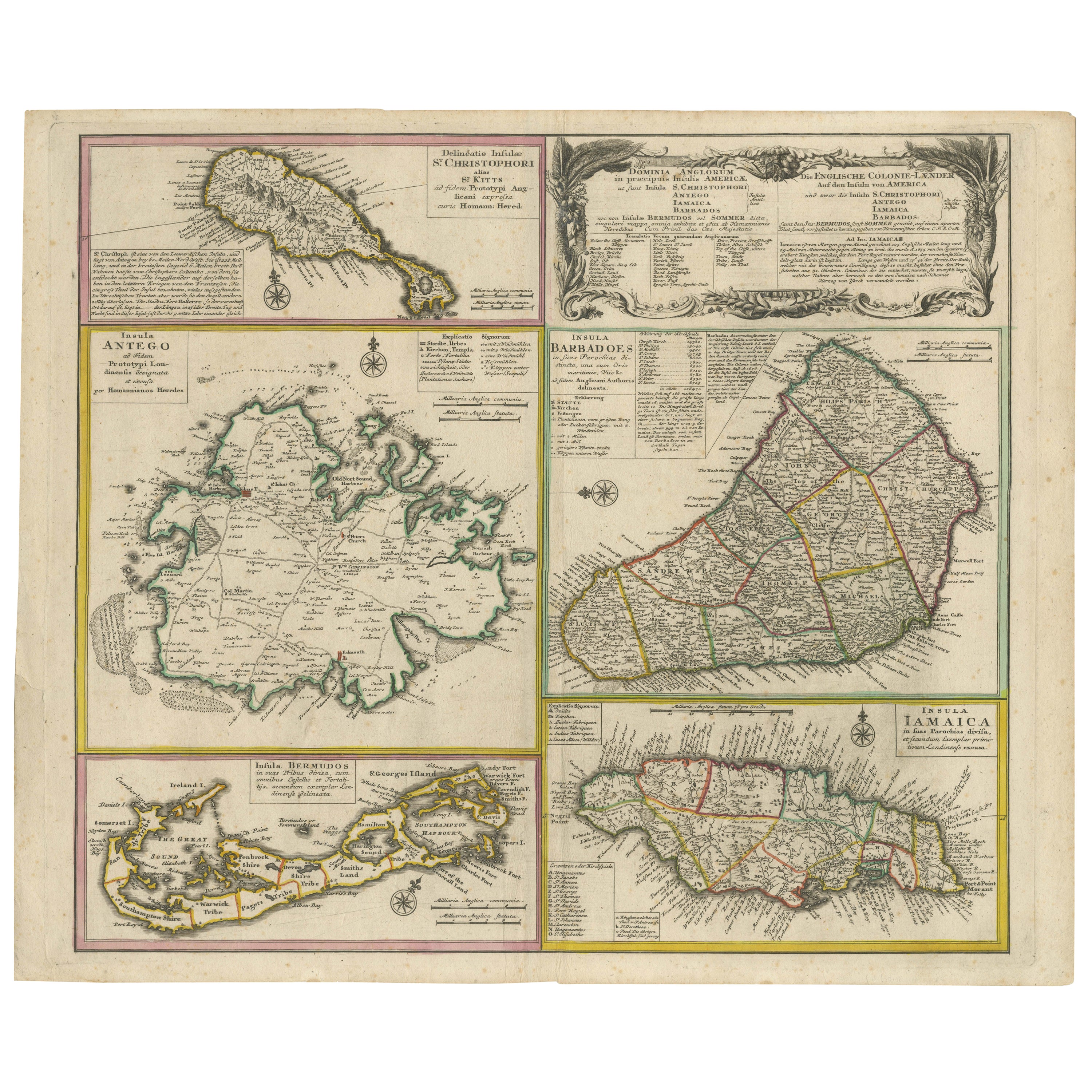
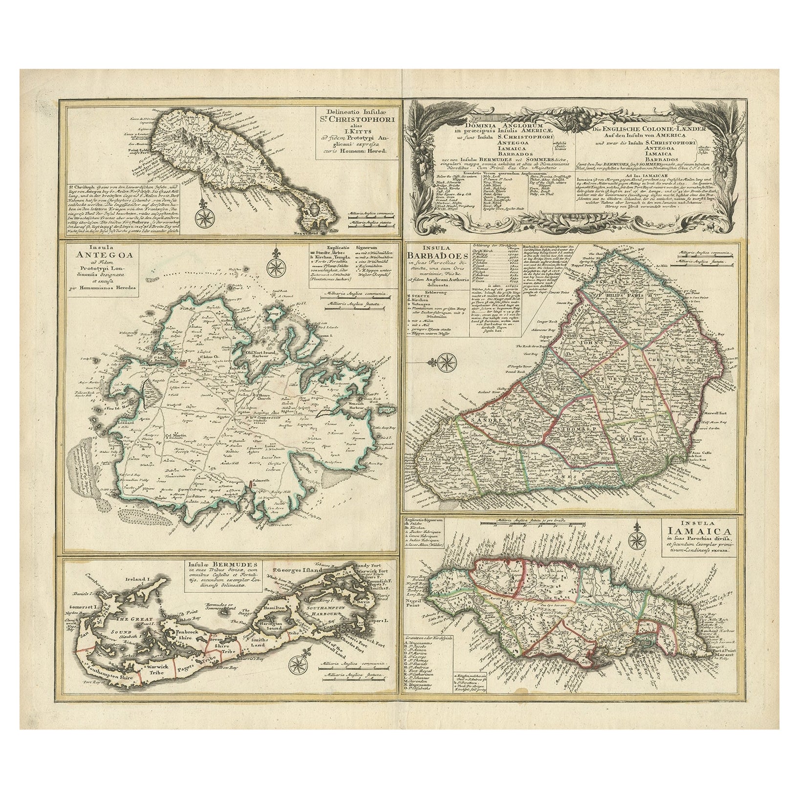
View AllOld 18th Century Composite Map of Key Caribbean Islands with Descriptive Texts
Located in Langweer, NL
Antique map titled 'Dominia Anglorum in praecipuis Insulis Americae ut sunt Insula S. Christophori, Antegoa, Iamaica, Barbados nec non Insulae Bermudes vel Sommers dictae. Die Englis...
Category
Antique 1740s Maps
Materials
Paper
$735 Sale Price
20% Off
Free Shipping
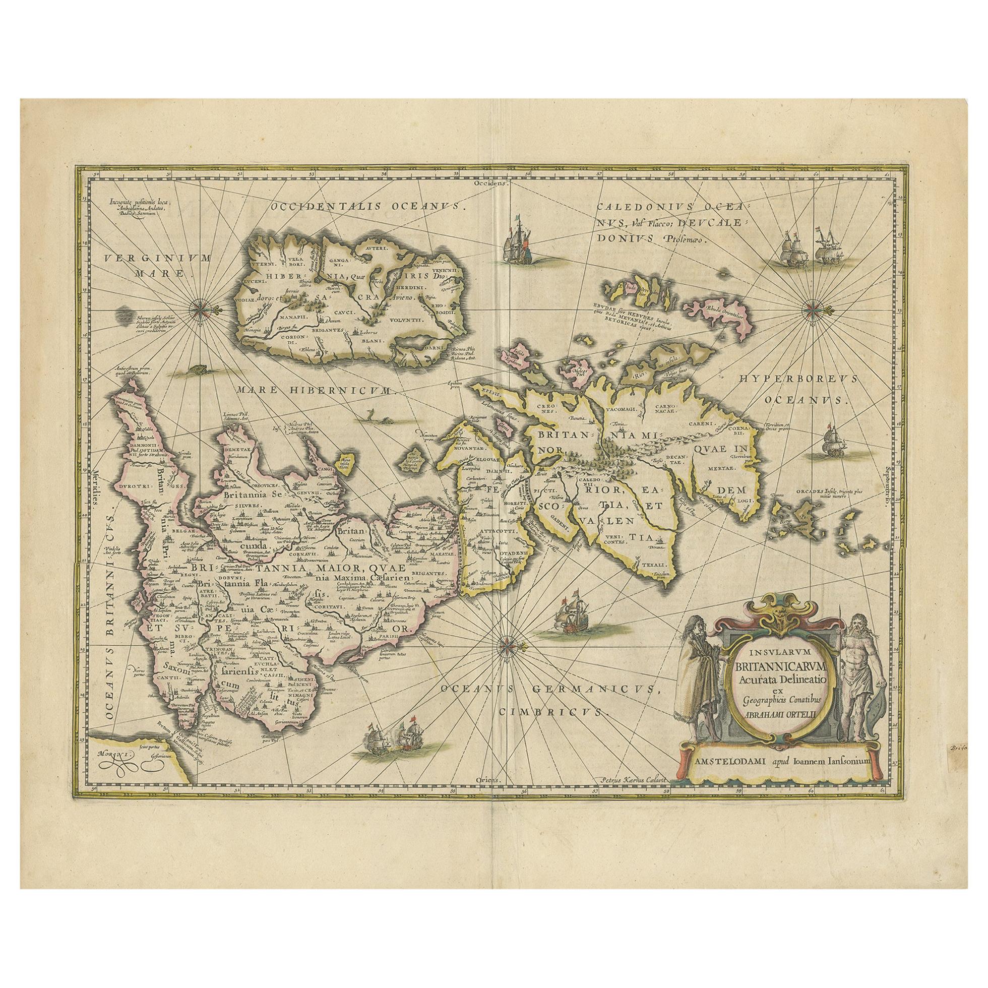
Antique Map of the Ancient British Isles by Janssonius 'circa 1640'
Located in Langweer, NL
Antique map titled 'Insularum Britannicarum Acurata Delineatio'. Original antique map of the ancient British Isles. England and Wales are labelled as B...
Category
Antique Mid-17th Century Maps
Materials
Paper

$896 Sale Price
20% Off
Original Old Map of St Kitts, Antigua, Bermuda, Barbados, and Jamaica, ca.1745
Located in Langweer, NL
Antique map titled 'Dominia Anglorum in praecipuis Insulis Americae ut sunt Insula S. Christophori, Antegoa, Iamaica, Barbados nec non Insulae Bermudes vel Sommers dictae. Die Englis...
Category
Antique 1740s Maps
Materials
Paper
$1,368 Sale Price
20% Off
Free Shipping
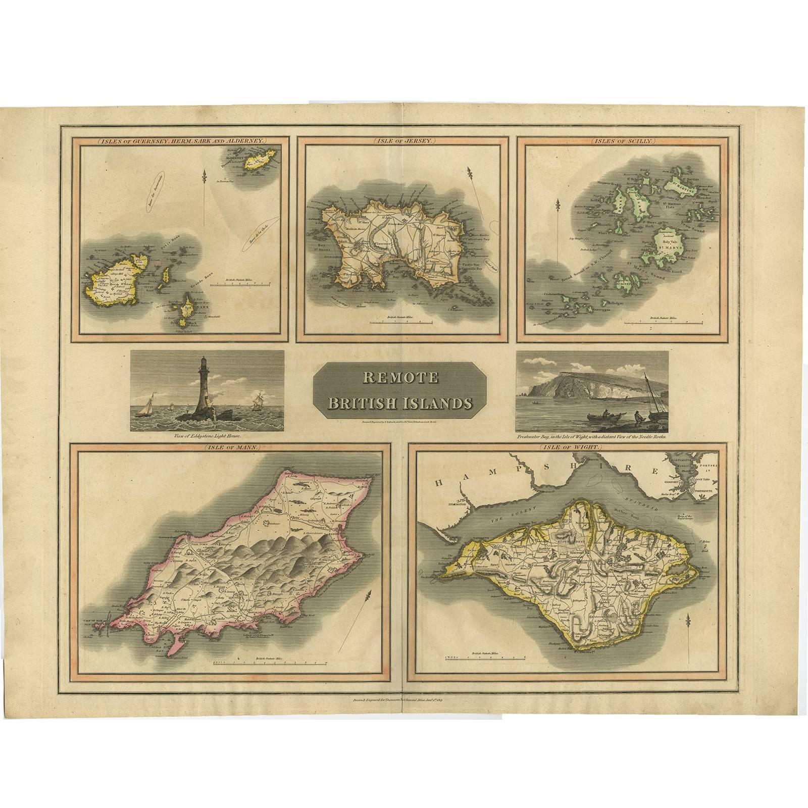
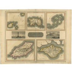
Antique Map of the British Islands by J. Thomson, 1817
Located in Langweer, NL
Group of 5 maps of the Channel Islands, Scilly, Jersey, the Isle of Mann and the Isle of Wight. Engraved views of the Eddystone Lighthouse and Freshwater Bay on the Isle of Wight, wi...
Category
Antique Early 19th Century Maps
Materials
Paper
Antique Map of Islands in the Mediterranean by Bowen, 'c.1760'
Located in Langweer, NL
Antique map titled 'Particular Draughts of some of the chief African Islands (..)'. Eight small maps on one sheet including 'Islands of Malta Goze & Cuming, An Accurate Chart of Cape de Verde Islands…, Island of St Helena.., Island of Madera, Island of Teneriffe, The Bay of Agoa…, The Dutch Fort at the Cape of Good Hope…, A Draught of Table Bay...
Category
Antique Mid-18th Century Maps
Materials
Paper

$471 Sale Price
20% Off
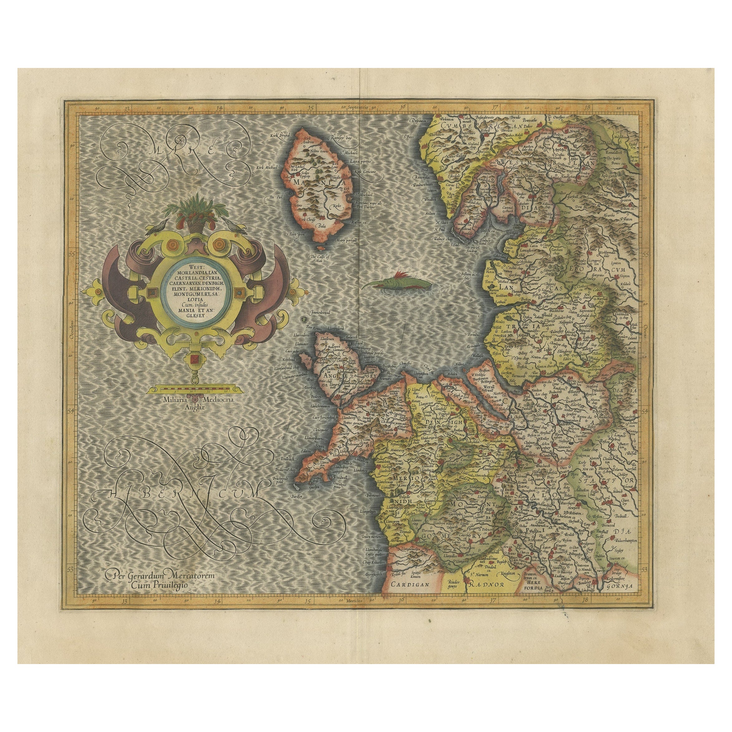
Antique Map of England by Mercator/Hondius, circa 1600
Located in Langweer, NL
Antique map titled 'Westmorlandia, Lancastria, Caernvan, Denbigh, Flint, Merionidh, Dalopia cum issulis Mania et Anglesey'. Original antique map of England...
Category
Antique 16th Century Maps
Materials
Paper
$896 Sale Price
20% Off
You May Also Like
St. Christophe 'St. Kitts' Island: An 18th Century Hand-colored Map by Bellin
By Jacques-Nicolas Bellin
Located in Alamo, CA
Jacques Bellin's copper-plate map of the Caribbean island of Saint Kitts entitled "Carte De De l'Isle St. Christophe Pour servir á l'Histoire Genle. des V...
Category
Antique Mid-18th Century French Maps
Materials
Paper

England, Scotland & Ireland: A Hand Colored Map of Great Britain by Tirion
By Isaak Tirion
Located in Alamo, CA
This is a hand-colored double page copperplate map of Great Britain entitled "Nieuwe Kaart van de Eilanden van Groot Brittannien Behelzende de Kon...
Category
Antique Mid-18th Century Dutch Maps
Materials
Paper

Ancient Map - Zeilan - Etching by Johannes Janssonius - 1650s
By Johannes Janssonius
Located in Roma, IT
Ancient Map - Zeilan is an ancient map realized in 1650 by Johannes Janssonius (1588-1664).
The Map is Hand-colored etching, with coeval watercoloring.
...
Category
1650s Modern Figurative Prints
Materials
Etching

Northwest Coast and Isle of Man Map
Located in Cheshire, GB
Greenville Collins Northwest Coast and Isle of Man. hand coloured chart, encased in an ebonised frame.
Dimensions
Height 26.5 Inches
Width 30 Inches
Depth 1 Inches
Category
Early 20th Century British Maps
Materials
Paper

$517 Sale Price
20% Off
England and the British Isles: A Large 17th Century Hand-colored Map by de Wit
By Frederick de Wit
Located in Alamo, CA
This is a large hand-colored 17th century map of England and the British Isles by Frederick de Wit entitled "Accuratissima Angliæ Regni et Walliæ Principatus", published in Amsterdam in 1680. It is a highly detailed map of England, Scotland, the Scottish Isles...
Category
Late 17th Century Other Art Style Landscape Prints
Materials
Engraving

Map of Lancashire
Located in Cheshire, GB
Saxton Map of Lancashire hand coloured. Encased in an ebonised frame.
Dimensions
Height 21 Inches
Width 24 Inches
Depth 1 Inches
Category
Early 20th Century British Maps
Materials
Paper

$757 Sale Price
20% Off
More Ways To Browse
Antique Olive Color
Small Antique Globes
Styles Of Antique Desks
Black And White Coffee Table
Curved Velvet Couch
Velvet Curved Sofa
Wood Round Coffee Tables
Antique Paper Flowers
Oak Brutalist
Used College Furniture
Wood Minimalist Chair
2002 Lamp
Antique Imperial Furniture
Gold Modern Coffee Table
Large Side Tables
18th Century Gilded Furniture
Fluted Column
Japanese Silver Ceramics