Items Similar to Cartographic Elegance: The British Raj's India, 1882 Atlas by Blackie and Son


Want more images or videos?
Request additional images or videos from the seller
1 of 9
Cartographic Elegance: The British Raj's India, 1882 Atlas by Blackie and Son
$421.60per set
$527.01per set20% Off
£312.43per set
£390.54per set20% Off
€352per set
€440per set20% Off
CA$575.57per set
CA$719.46per set20% Off
A$640.30per set
A$800.37per set20% Off
CHF 335.65per set
CHF 419.57per set20% Off
MX$7,824.29per set
MX$9,780.36per set20% Off
NOK 4,274.11per set
NOK 5,342.64per set20% Off
SEK 4,023.49per set
SEK 5,029.36per set20% Off
DKK 2,680.10per set
DKK 3,350.12per set20% Off
Shipping
Retrieving quote...The 1stDibs Promise:
Authenticity Guarantee,
Money-Back Guarantee,
24-Hour Cancellation
About the Item
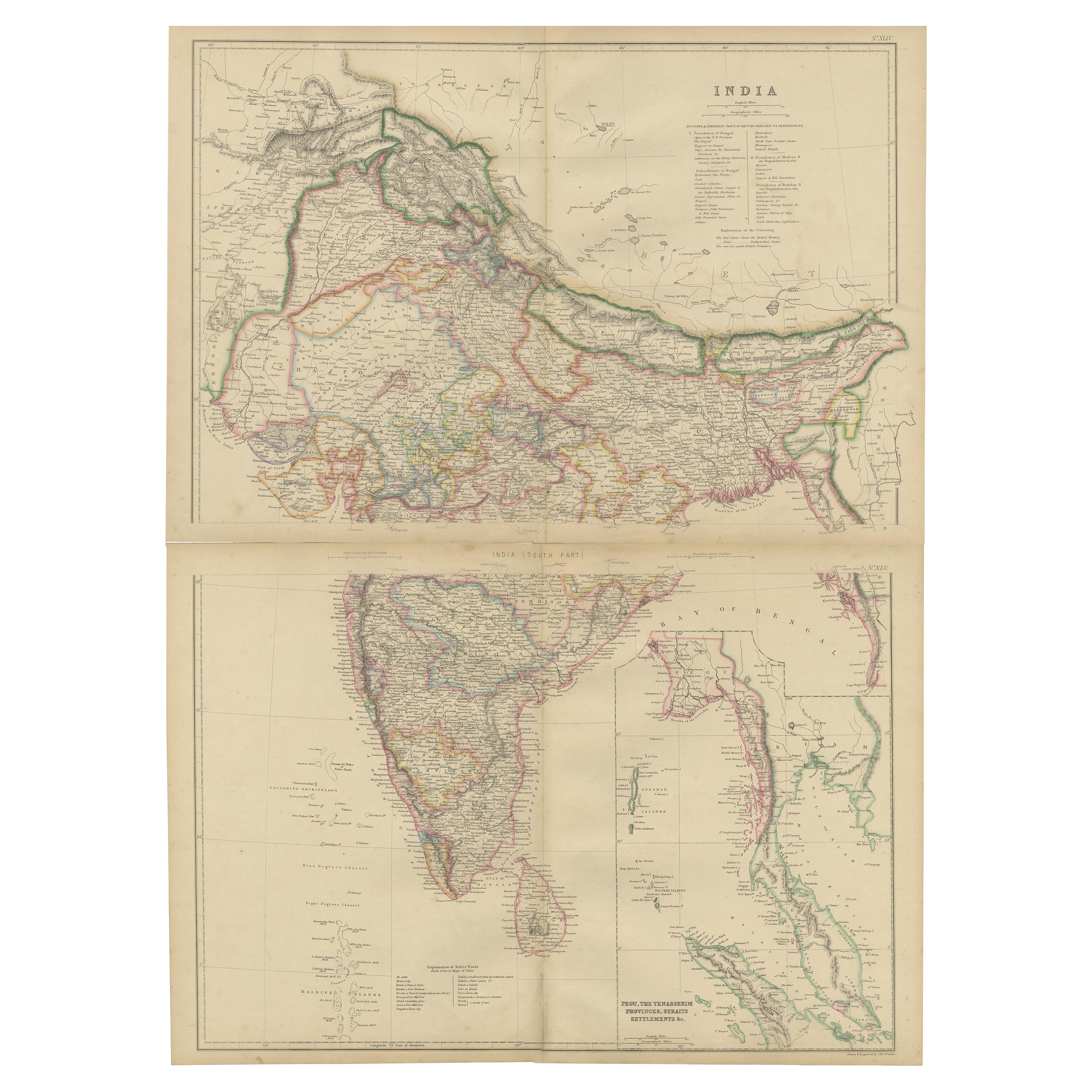
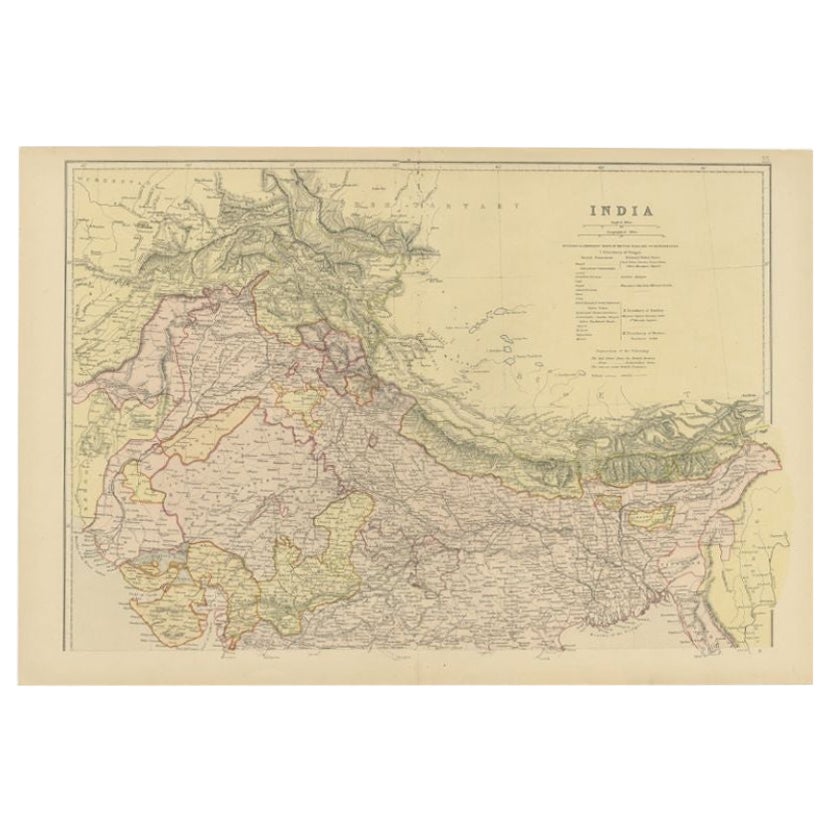
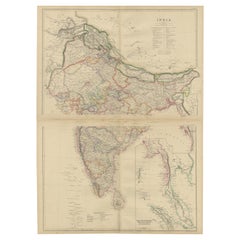
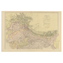
These two maps are part of an 1882 atlas published by Blackie and Son, a notable publishing company in the 19th century known for their educational books and detailed atlases. The maps represent the geographical understanding of India during the British Raj, with an impressive degree of detail and accuracy for the time.
The northern map includes the Himalayan frontier, with color-coded regions denoting various provinces and princely states such as Punjab, Kashmir, and Nepal. Each region is outlined with distinct colors like red and yellow, and the map is rich with place names, including cities, rivers, and mountain ranges. This part of the map also extends into Central Asia, indicating areas labeled as 'Turkestan,' reflecting the interest and influence of the British Empire in the region.
The southern map details the subcontinent from the central plains downward, incorporating the Deccan Plateau, the Eastern and Western Ghats, and extending to the southernmost point of the Indian peninsula. The island of Ceylon, now known as Sri Lanka, is prominently featured along with the coastal outlines and internal administrative boundaries. The Maldives and Lakshadweep archipelagos are also depicted, showcasing the expanse of British nautical knowledge.
Both maps display an overlay of longitude and latitude lines, indicative of their navigational utility. The legends and notations, written in English, provide information about the transportation routes, including railways, which were an essential aspect of colonial administration and economic activity at the time. These maps would have served as critical tools for travel, trade, and governance during the period of British colonial rule in India. The meticulous craftsmanship of these maps provides a window into the era's cartography and the geopolitical landscape as perceived by the British.
- Dimensions:Height: 14.97 in (38 cm)Width: 22.45 in (57 cm)Depth: 0 in (0.02 mm)
- Sold As:Set of 2
- Materials and Techniques:
- Period:
- Date of Manufacture:1882
- Condition:Good condition, folding line in the middle of both maps. The outer borders are slightly discolored due to age, but not the image. This two maps is ideal for joined framing. Study the images carefully.
- Seller Location:Langweer, NL
- Reference Number:Seller: BG-13601-2-46, BG-13601-2-471stDibs: LU3054337695962
About the Seller
5.0
Recognized Seller
These prestigious sellers are industry leaders and represent the highest echelon for item quality and design.
Platinum Seller
Premium sellers with a 4.7+ rating and 24-hour response times
Established in 2009
1stDibs seller since 2017
2,494 sales on 1stDibs
Typical response time: 1 hour
- ShippingRetrieving quote...Shipping from: Langweer, Netherlands
- Return Policy
Authenticity Guarantee
In the unlikely event there’s an issue with an item’s authenticity, contact us within 1 year for a full refund. DetailsMoney-Back Guarantee
If your item is not as described, is damaged in transit, or does not arrive, contact us within 7 days for a full refund. Details24-Hour Cancellation
You have a 24-hour grace period in which to reconsider your purchase, with no questions asked.Vetted Professional Sellers
Our world-class sellers must adhere to strict standards for service and quality, maintaining the integrity of our listings.Price-Match Guarantee
If you find that a seller listed the same item for a lower price elsewhere, we’ll match it.Trusted Global Delivery
Our best-in-class carrier network provides specialized shipping options worldwide, including custom delivery.More From This Seller
View AllVintage Cartographic Collection Set of India Explored - W. G. Blackie's 1859
Located in Langweer, NL
Antique map titled 'India'. Original antique map of India with inset maps of Pegu, the Tenasserim Provinces, straits settlements. This map originate...
Category
Antique Mid-19th Century Maps
Materials
Paper
$383 Sale Price / set
20% Off
Authentic Antique Map of India and Ceylon, '1875'
Located in Langweer, NL
Antique map titled 'Carte générale des Indes'. Large map of India and Ceylon. This map originates from 'Atlas de Géographie Moderne Physique et Politique' by A. Levasseur. Published ...
Category
Antique Late 19th Century Maps
Materials
Paper
$479 Sale Price
20% Off
Antique Map of Northern India by Blackie & Son, 1860
Located in Langweer, NL
Antique map titled 'India'. Old map depicting northern India. This map originates from 'The Comprehensive Atlas & Geography of the World, Compiled and Engraved from the most Authenti...
Category
Antique 19th Century Maps
Materials
Paper
Antique Map of India and Ceylon by Lapie, 1842
Located in Langweer, NL
Antique map titled 'Carte de l'Inde en deca et au dela du Gange'. Map of India and Ceylon (Sri Lanka). This map originates from 'Atlas universel de géographie ancienne et moderne (.....
Category
Antique Mid-19th Century Maps
Materials
Paper

$527 Sale Price
20% Off
Ancient Cartography of the Indian Subcontinent, Published in 1880
Located in Langweer, NL
This map is titled "INDIA," and it provides a detailed view of the Indian subcontinent with various inset maps that offer additional historical and geographical context.
The main ma...
Category
Antique 1880s Maps
Materials
Paper

$354 Sale Price
20% Off
Free Shipping
Mid-19th Century Decorative Map of India with Cultural and Natural Vignettes
Located in Langweer, NL
The Tallis maps, including the one of India, are known for their detailed and ornamental style. They were produced during the mid-19th century, a time when cartographic publishing became as much an art form as a means of geographic representation.
John Tallis & Company, founded by John Tallis, was known for creating maps with elaborate borders and vignettes surrounding the map itself. These maps often included illustrations that depicted scenes representative of the region's culture, significant local wildlife, architectural landmarks, and portraits of indigenous peoples...
Category
Antique 1850s Maps
Materials
Paper

$297 Sale Price
20% Off
You May Also Like
India (Southern Sheet), English antique map by Alexander Keith Johnston, 1901
Located in Melbourne, Victoria
'India (Southern Sheet)', antique lithographic map by Keith Johnston.
Inset maps of 'Bombay Island & Town', 'Madras & Environs', and 'South-Eastern Provinces of India'.
Central vertical fold as issued.
495mm by 625mm (sheet)
Alexander Keith...
Category
Early 20th Century Victorian More Prints
Materials
Lithograph

Original Antique Map of India by Dower, circa 1835
Located in St Annes, Lancashire
Nice map of India
Drawn and engraved by J.Dower
Published by Orr & Smith. C.1835
Unframed.
Free shipping
Category
Antique 1830s English Maps
Materials
Paper

Large Original Vintage Map of India, circa 1920
Located in St Annes, Lancashire
Great map of India
Original color.
Good condition / repair to some minor damage just above Sri Lanka. Shown in the last image.
Published by Alexander Gross
Unframed.
Category
Vintage 1920s English Maps
Materials
Paper

Antique 1803 Italian Map of Asia Including China Indoneseia India
Located in Amsterdam, Noord Holland
Antique 1803 Italian Map of Asia Including China Indoneseia India
Very nice map of Asia. 1803.
Additional information:
Type: Map
Country of Manufacturing: Europe
Period: 19th centu...
Category
Antique 19th Century European Maps
Materials
Paper

$584 Sale Price
20% Off
Large Original Vintage Map of S.E Asia, with a Vignette of Singapore
Located in St Annes, Lancashire
Great map of South East Asia
Original color. Good condition
Published by Alexander Gross
Unframed.
Category
Vintage 1920s English Maps
Materials
Paper

Ancient National Atlas of France with Marengo
Located in Alessandria, Piemonte
Ancient National Atlas of France with the department of Marengo: a rare French etching dated 1806.
ST/178.
Category
Antique Early 19th Century French Other Prints
Materials
Paper

More Ways To Browse
British India
British Empire
Southern Colonial
India Raj
Colonial British India Furniture
Railway Map
British Raj
Colonial Sri Lankan
Antique Indian Windows
Himalayan Antique
Antique Punjab
Antique Nautical Tools
Vintage Art Deco Rugs
Vintage Serving Forks
Herati Rug
Italian Wood Console Tables
Maison Jansen Argentina
Antique Oushak