Items Similar to Charming Miniature Map of Thrace or Thrake in Southeast Europe, 1685
Want more images or videos?
Request additional images or videos from the seller
1 of 5
Charming Miniature Map of Thrace or Thrake in Southeast Europe, 1685
$316.31
$395.3920% Off
£235.43
£294.2920% Off
€264
€33020% Off
CA$433.27
CA$541.5820% Off
A$481.89
A$602.3620% Off
CHF 251.63
CHF 314.5320% Off
MX$5,864.04
MX$7,330.0520% Off
NOK 3,213.65
NOK 4,017.0620% Off
SEK 3,013.83
SEK 3,767.2920% Off
DKK 2,009.74
DKK 2,512.1720% Off
Shipping
Retrieving quote...The 1stDibs Promise:
Authenticity Guarantee,
Money-Back Guarantee,
24-Hour Cancellation
About the Item
Antique map titled 'Thraciae Descriptio.'
Charming miniature map of Thrace, from the pocket atlas 'Introductionis in Universam Geographiam tam Veterem quam novam .. Acessit P. Bertii (Bertius) Brevarium Orbis Terrarum', by Ph. Cluverius (Cluver). Source unknown, to be determined.
Thrake is a geographical and historical region in Southeast Europe, now split among Bulgaria, Greece, and Turkey, which is bounded by the Balkan Mountains to the north, the Aegean Sea to the south, and the Black Sea to the east. It comprises southeastern Bulgaria (Northern Thrace), northeastern Greece (Western Thrace), and the European part of Turkey (East Thrace). The region's boundaries are based on that of the Roman Province of Thrace; the lands inhabited by the ancient Thracians extended in the north to modern-day Northern Bulgaria and Romania and to the west into the region of Macedonia.
Artists and Engravers: Philipp Cluver (1580 - 1622), early modern German geographer and historian.
- Dimensions:Height: 5.12 in (13 cm)Width: 5.32 in (13.5 cm)Depth: 0 in (0.02 mm)
- Materials and Techniques:
- Period:1680-1689
- Date of Manufacture:1685
- Condition:Condition: Good, given age. Original folds as issued. General age-related toning and/or occasional minor defects from handling. Please study image carefully.
- Seller Location:Langweer, NL
- Reference Number:Seller: PCT-620491stDibs: LU3054327269962
About the Seller
5.0
Recognized Seller
These prestigious sellers are industry leaders and represent the highest echelon for item quality and design.
Platinum Seller
Premium sellers with a 4.7+ rating and 24-hour response times
Established in 2009
1stDibs seller since 2017
2,502 sales on 1stDibs
Typical response time: <1 hour
- ShippingRetrieving quote...Shipping from: Langweer, Netherlands
- Return Policy
Authenticity Guarantee
In the unlikely event there’s an issue with an item’s authenticity, contact us within 1 year for a full refund. DetailsMoney-Back Guarantee
If your item is not as described, is damaged in transit, or does not arrive, contact us within 7 days for a full refund. Details24-Hour Cancellation
You have a 24-hour grace period in which to reconsider your purchase, with no questions asked.Vetted Professional Sellers
Our world-class sellers must adhere to strict standards for service and quality, maintaining the integrity of our listings.Price-Match Guarantee
If you find that a seller listed the same item for a lower price elsewhere, we’ll match it.Trusted Global Delivery
Our best-in-class carrier network provides specialized shipping options worldwide, including custom delivery.More From This Seller
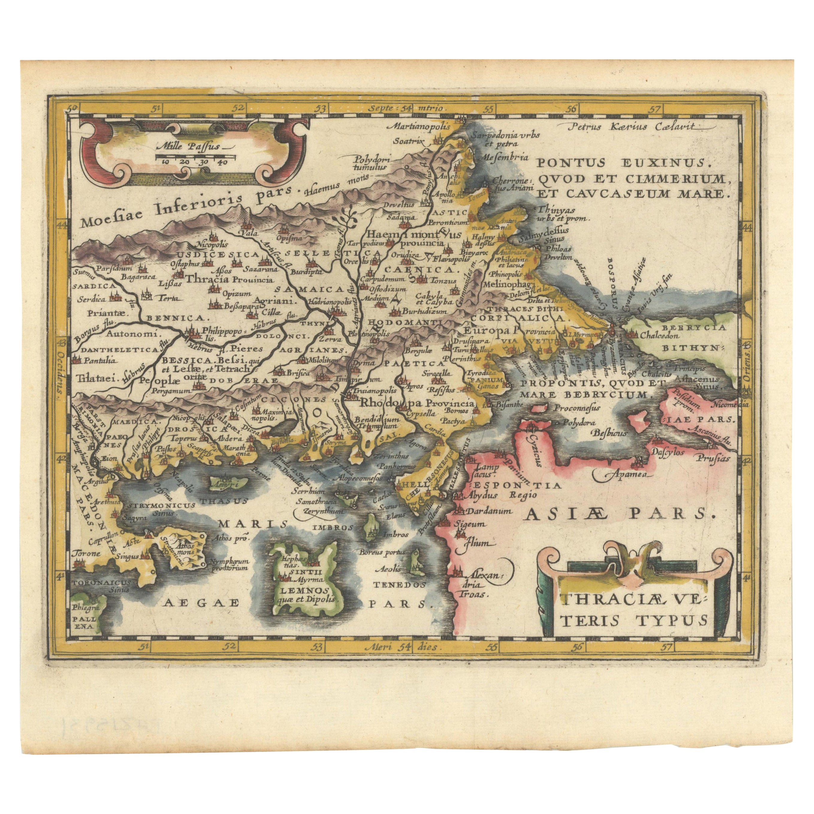
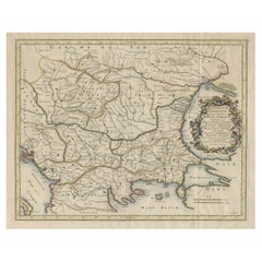
View AllOriginal Old Map of Northeastern Greece & Northwestern Turkey, Published in 1661
Located in Langweer, NL
This small map was engraved by Petrus Kaerius and is based on Ortelius' map of the same title. It covers the ancient region of Thrace, present-day European Turkey and part of Greece....
Category
Antique 1660s Maps
Materials
Paper
$402 Sale Price
20% Off
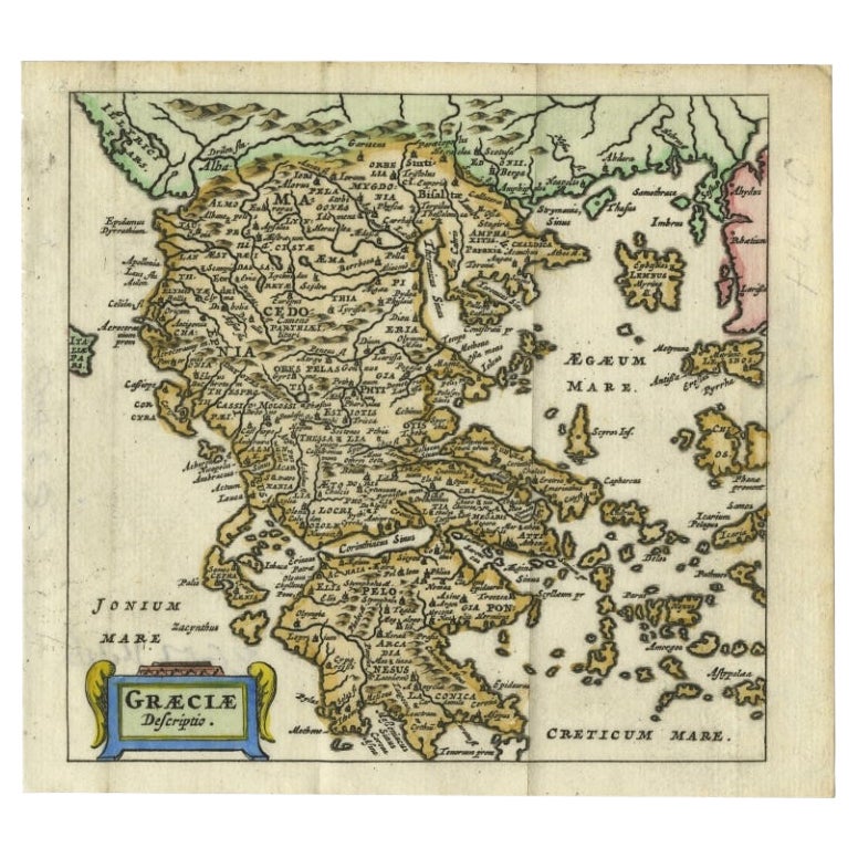
Charming 18th Century Miniature Map of Greece, 1685
Located in Langweer, NL
Antique map titled 'Graeciae Descriptio.' Charming miniature map of Greece from the pocket atlas 'Introductionis in Universam Geographiam tam Veterem qu...
Category
Antique 17th Century Maps
Materials
Paper
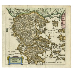
$335 Sale Price
20% Off
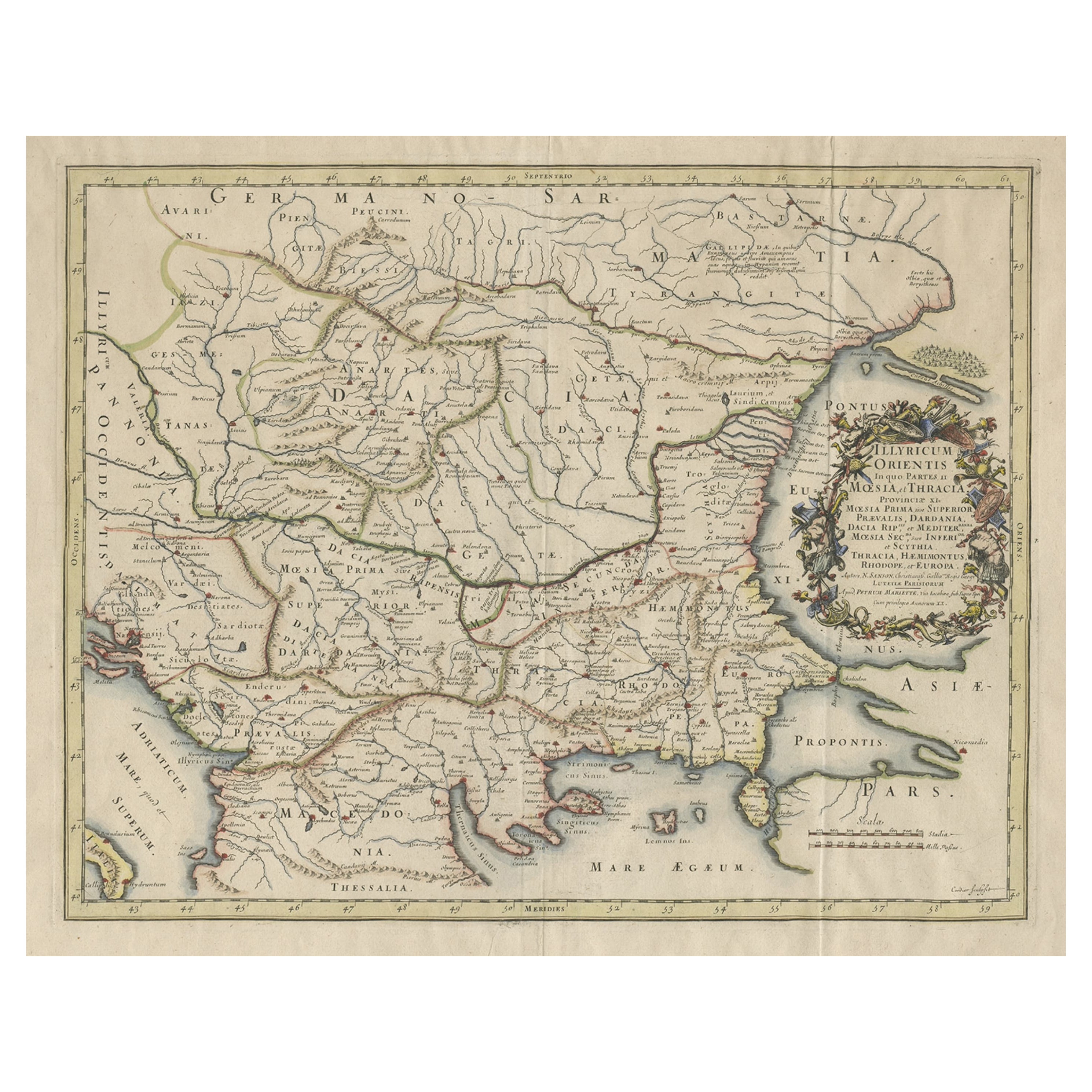
Map of Region Near the Baltic Sea, Present Day Bulgaria, Romania & Turkey, c1670
Located in Langweer, NL
Antique map titled 'Illyricum Orientis: In quo Partes II Moesia et Thracia'.
Engraved map of the area west of the Baltic Sea, present day Bulgaria, Romania, and Turkey. The map i...
Category
Antique 1670s Maps
Materials
Paper
$1,294 Sale Price
20% Off
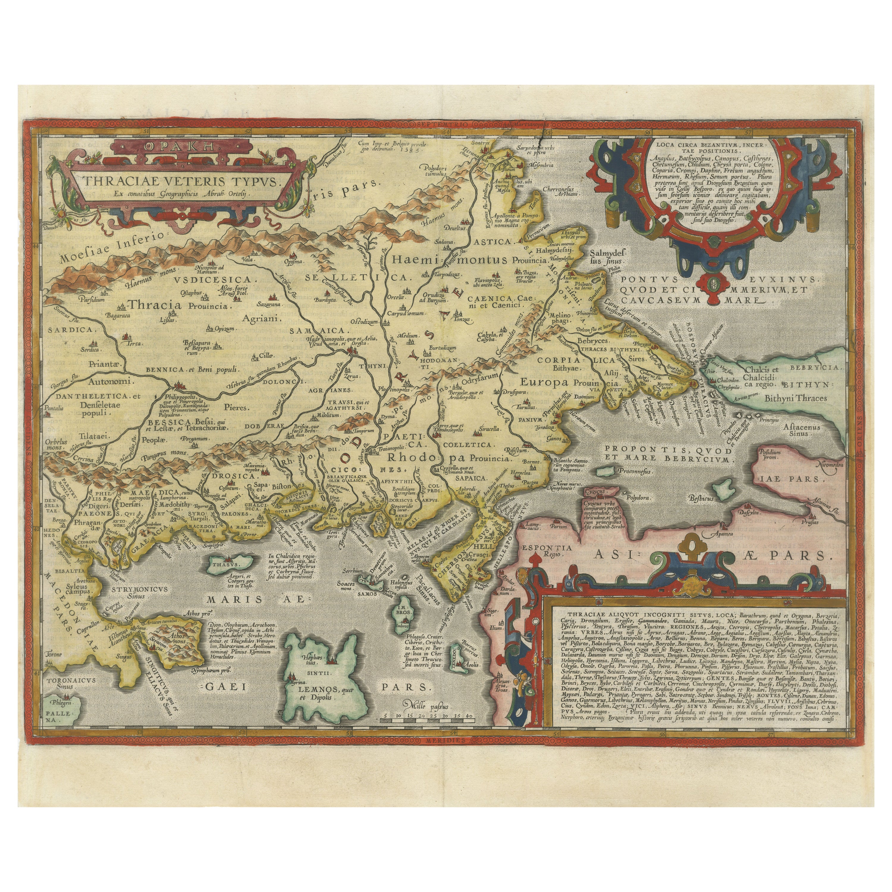
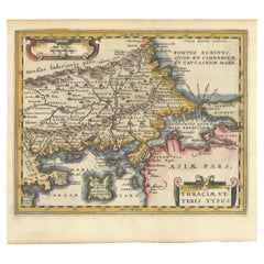
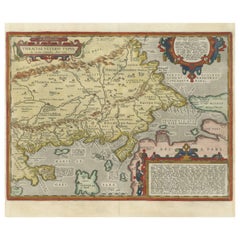
Thraciae Veteris Typus – 1618 Ortelius Map of Ancient Thrace with Hand Color
Located in Langweer, NL
Thraciae Veteris Typus – 1618 Ortelius Map of Ancient Thrace with Hand Color
This striking early 17th-century map, Thraciae Veteris Typus, was published in 1618 by Abraham Orteliu...
Category
Antique Early 1600s Maps
Materials
Paper
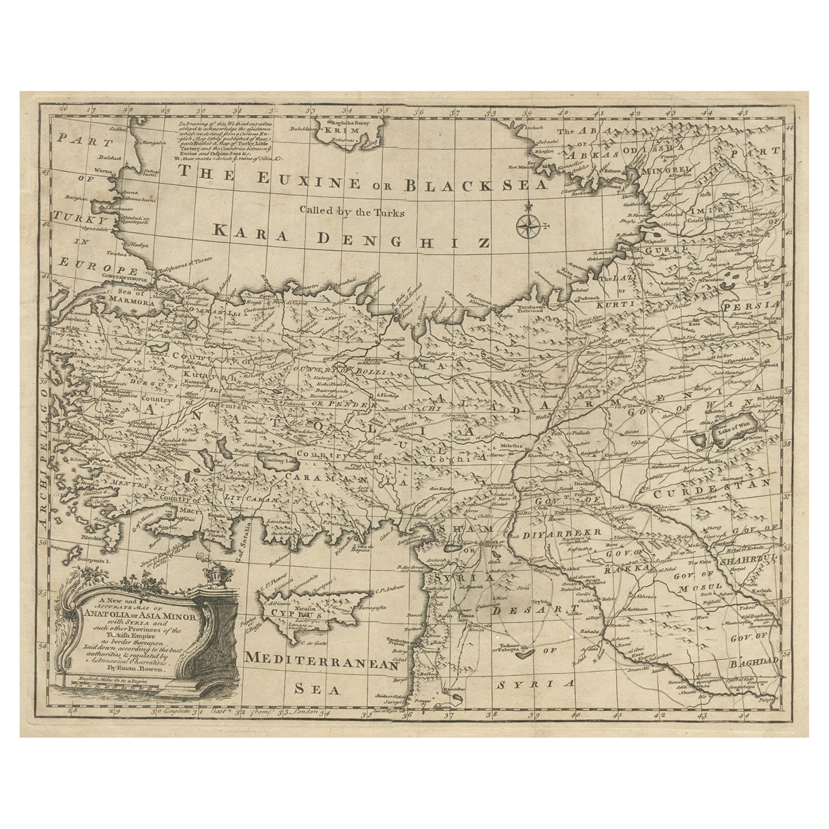
Antique Map of Asia Minor with Cyprus, Syria and Turkey and the Black Sea, 1747
Located in Langweer, NL
Antique map Middle East titled 'A New and accurate map of Anatolia or Asia Minor, with Syria and such other provinces of the Turkish Empire (.....
Category
Antique 18th Century Maps
Materials
Paper
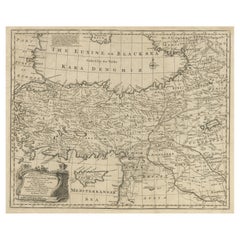
$431 Sale Price
20% Off
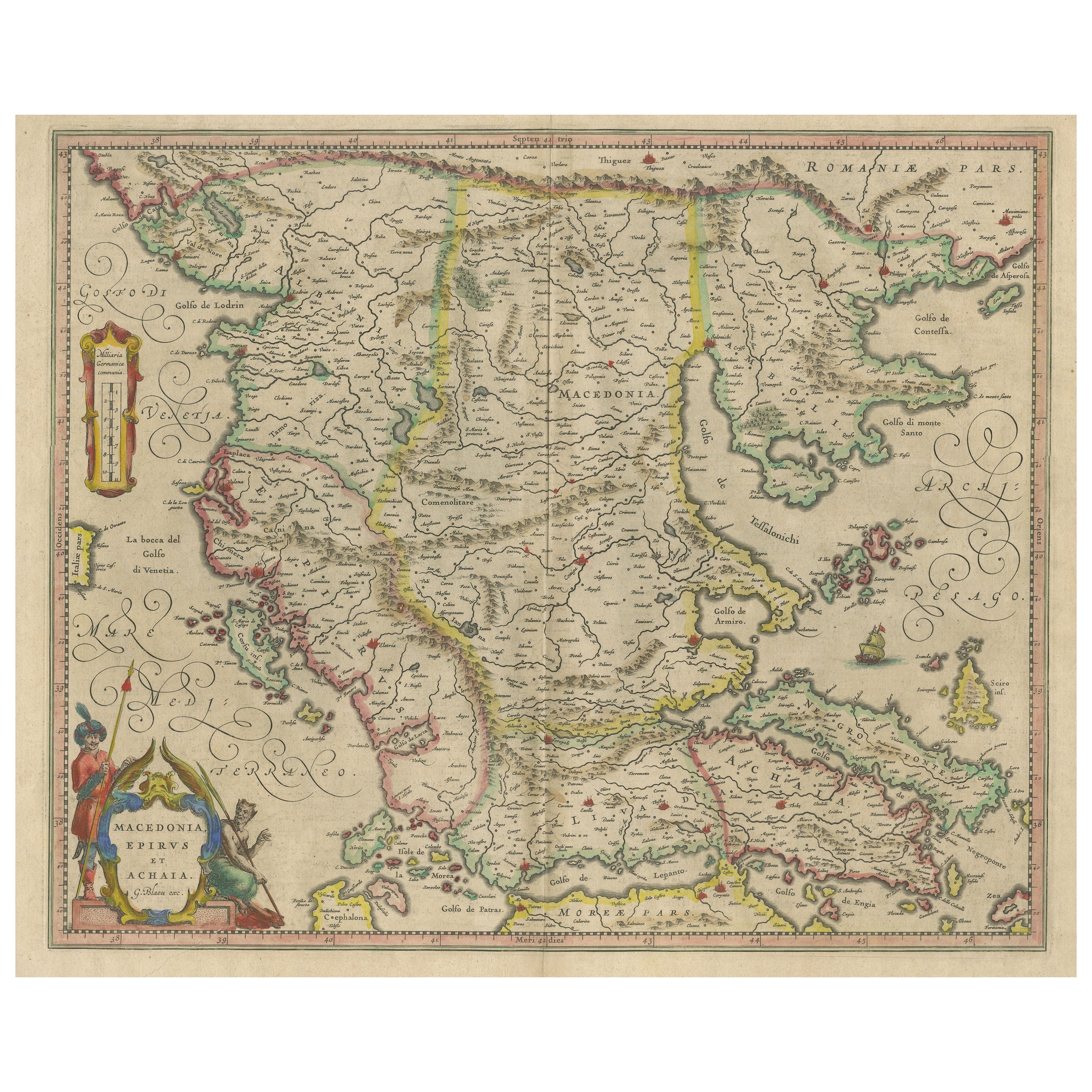
Antique Map of Macedonia, Northern Greece and part of Turkey in Europe
Located in Langweer, NL
Antique map titled 'Macedonia Epirus et Achaia'. Original old map of Macedonia, northern Greece, and part of Turkey in Europe. Published by W.J. Blaeu, circa 1640.
Willem Janszoon ...
Category
Antique Mid-17th Century Maps
Materials
Paper
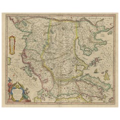
$766 Sale Price
20% Off
You May Also Like
18th Century Map of the Southern Balkans by Giovanni Maria Cassini
By Giovanni Maria Cassini
Located in Hamilton, Ontario
18th century map by Italian engraver Giovanni Maria Cassini (Italy 1745-1824).
Map of the Southern Balkans: Rome. Hand colored and copper engraved print done in the year 1788. It in...
Category
Antique 18th Century Italian Maps
Materials
Paper

$795 Sale Price
36% Off
Hand-Colored 18th Century Homann Map of the Black Sea, Turkey and Asia Minor
By Johann Baptist Homann
Located in Alamo, CA
An attractive original early 18th century hand-colored map of the Black Sea and Turkey entitled "Carte de L'Asie Minevre ou de la Natolie et du Pont Evxin Tiree des Voyages et des Ob...
Category
Antique Early 18th Century German Maps
Materials
Paper

Engraving Depicting 16th Century Map of Terra Sancta
Located in Buchanan, MI
Abraham Ortelius (Flemish, 1527-1598) Terra Sancta.
Engraving depicting 16th century map of Terra Sancta. Site 15" x 19.5.
Category
Antique 18th Century and Earlier Maps
Materials
Paper

Southern Greece: A Large 17th C. Hand-colored Map by Sanson and Jaillot
By Nicolas Sanson
Located in Alamo, CA
This large original hand-colored copperplate engraved map of southern Greece and the Pelopponese Peninsula entitled "La Moree Et Les Isles De Zante, Cefalonie, Ste. Marie, Cerigo & C...
Category
Antique 1690s French Maps
Materials
Paper

Southern & Eastern Europe: A Large 17th C. Hand-colored Map by Sanson & Jaillot
By Nicolas Sanson
Located in Alamo, CA
This large hand-colored map entitled "Estats de L'Empire des Turqs en Europe, ou sont les Beglerbeglicz our Gouvernements" was originally created by Nicholas Sanson d'Abbeville and t...
Category
Antique 1690s French Maps
Materials
Paper

17th Century Nicolas Visscher Map of Southeastern Europe
Located in Hamilton, Ontario
A beautiful, highly detailed map of southeastern Europe by Nicolas Visscher. Includes regions of Northern Italy (showing the cities Bologna, Padua, and Venice), Bohemia, Austria (sho...
Category
Antique 17th Century Dutch Maps
Materials
Paper

$1,350 Sale Price
38% Off
More Ways To Browse
Bulgarian Artists
Map Of Ancient Greece
Maps Balkans
Romania Map
Antique Maps Of Sicily
Antique Celestial Maps
Antique Compass Maritime Compasses
Bengal Map
J C Walker Map
Map Of Ancient Greece
Ptolemy Map
Antique Marine Compass
Map Of Jerusalem
1820 World Map
Cyprus Antique Maps
Antique Ecuador
Antique Map Of Thailand
Antique Mississippi Map