Items Similar to Colored wall map of the WORLD


Want more images or videos?
Request additional images or videos from the seller
1 of 20
Colored wall map of the WORLD
$28,755.45
$35,944.3120% Off
£21,402.59
£26,753.2420% Off
€24,000
€30,00020% Off
CA$39,387.77
CA$49,234.7220% Off
A$43,807.80
A$54,759.7520% Off
CHF 22,875.07
CHF 28,593.8420% Off
MX$533,094.34
MX$666,367.9220% Off
NOK 292,149.58
NOK 365,186.9720% Off
SEK 273,984.76
SEK 342,480.9620% Off
DKK 182,703.62
DKK 228,379.5320% Off
Shipping
Retrieving quote...The 1stDibs Promise:
Authenticity Guarantee,
Money-Back Guarantee,
24-Hour Cancellation
About the Item
“Mappe Monde, contenant les Parties Connues du Globe Terrestre”
CHAMBON, Gobert-Denis (France, 17.. - 1781)
Paris, Longchamps et Janvier, 1754
Size H. 115 x W. 145 cm.
Gobert-Denis Chambon made copper engraving after the work of Guillaume De L’Isle, published in 1754 by Jean Janvier and S.G. Longschamps.
A huge wall map of the world in two hemispheres printed on two sheets, depicting the Eastern and Western hemispheres supported by two male figures, decorated at the bottom right and left with two celestial hemispheres (boreal and southern) and at the bottom in the middle with an armillary sphere, in addition.
This map is most notable for its depiction of the Sea of Japan labeled "Mer de Corée" and of "Mer de L'Ouest" or Sea of the West - a great sea, easily the size of the Mediterranean, to flow from the then-known Strait of Juan de Fuca. Australia and New Zealand are depicted in typical post-Tasman form, however, unlike other French cartographers at the time who tended to join New Guinea to Tasmania in a single and highly creative, imaginary coastline, Janvier leaves those undiscovered coastlines blank.
Early Dutch discoveries are noted in Australia and New Zealand, as are other recent discoveries worldwide. The tracks of Magellan, Vasco da Gama, and Francis Drake are shown. According to Don McGuirk, this map shows an early copy of a Buache type 1 Mer de l'Ouest.
Four states of this map were found.
- State 1: Dated 1751.
- State 2: Dated 1754. Under the title, engraved by "Chambon". Lower left, "A PARIS, chés les Sieurs Longchamps et Janvier, Geographes, rue St Jacques a l'Enseigne de la Place des Victoires." This state and later states is found surrounded by borders with biblical vignettes.
- State 3: Dated 1788. Now "chez Mondhare and Jean".
- State 4: Dated An 8 (1799-1800). Now "Paris Chez Jean rue Jean de Beauvois.
Reference: McGuirk, The Last Great Cartographic Myth - Mer de l'Ouest, 30 (Later colored. Some parts contemporarily underlaid with paper, for protective reason. Repair of a split on the crossing of folds. Some paper discoloration. Some staining and folds)
- Creator:Chambon (Maker)
- Dimensions:Height: 45 in (114.3 cm)Width: 57 in (144.78 cm)Depth: 0.8 in (2.04 cm)
- Style:French Provincial (Of the Period)
- Materials and Techniques:
- Place of Origin:
- Period:
- Date of Manufacture:1754
- Condition:Repaired: Some parts are contemporarily underlaid with paper, for protective reasons. Repair of a split on the crossing of folds. Wear consistent with age and use.
- Seller Location:ZWIJNDRECHT, NL
- Reference Number:Seller: Jacob B. de Roo, owner since 2004 from Antiquariaat De Roo1stDibs: LU9419237770662
About the Seller
No Reviews Yet
Vetted Professional Seller
Every seller passes strict standards for authenticity and reliability
Established in 2004
1stDibs seller since 2023
- ShippingRetrieving quote...Shipping from: ZWIJNDRECHT, Netherlands
- Return Policy
Authenticity Guarantee
In the unlikely event there’s an issue with an item’s authenticity, contact us within 1 year for a full refund. DetailsMoney-Back Guarantee
If your item is not as described, is damaged in transit, or does not arrive, contact us within 7 days for a full refund. Details24-Hour Cancellation
You have a 24-hour grace period in which to reconsider your purchase, with no questions asked.Vetted Professional Sellers
Our world-class sellers must adhere to strict standards for service and quality, maintaining the integrity of our listings.Price-Match Guarantee
If you find that a seller listed the same item for a lower price elsewhere, we’ll match it.Trusted Global Delivery
Our best-in-class carrier network provides specialized shipping options worldwide, including custom delivery.More From This Seller
View AllA beautiful Celestial Table Globe produced by Gerard & Leonard Valk
By Gerard and Leonard Valk
Located in ZWIJNDRECHT, NL
A magnificent and very rare early 18th century celestial table globe produced by Gerard and Leonard Valk. Established at the end of the previous ...
Category
Antique Early 18th Century Dutch Dutch Colonial Globes
Materials
Other
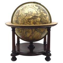
$191,702 Sale Price
20% Off
Free Shipping
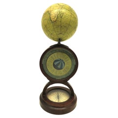
An English POCKET GLOBE with dial for time zones
By Newton and Son
Located in ZWIJNDRECHT, NL
NEWTON & SON (fl.1840-61)
AN ENGLISH POCKET GLOBE WITH A DIAL FOR TIME ZONES, CIRCA 1835
A previously unrecorded stand for an early-19th-century English globe.
A 3-inch (7.6cm.) di...
Category
Antique 1830s British Other Globes
Materials
Mahogany
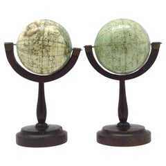
A fine pair of miniature globes on stands
By Karl Muller
Located in ZWIJNDRECHT, NL
A rare pair of miniature terrestrial and celestial globes.
by K. Müller, 1822
Karlsruhe, Germany
Diameter globes: 7 cm. Total high: 14,5 cm.
Each with 12 hand-coloured engraved p...
Category
Antique Early 19th Century German International Style Globes
Materials
Hardwood, Paper
Seminal guide to the East and West Indies, with 42 coloured maps and plates
By Jan Huygen van Linschoten
Located in ZWIJNDRECHT, NL
Seminal guide to the East and West Indies, with 42 double-page and folding plates, including 6 maps, all engravings beautifully coloured by a contemporary hand
LINSCHOTEN, Jan Huygh...
Category
Antique Early 17th Century Dutch Dutch Colonial Books
Materials
Paper

$269,582 Sale Price
25% Off
Free Shipping
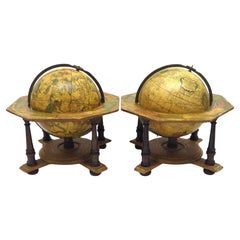
A decorative pair of rare table globes in a fine condition.
By Johann Gabriel Doppelmayr
Located in ZWIJNDRECHT, NL
These pair of globes, dated 1730, are original and in fine condition.
Title:
Globus terrestris novus Loca Terrae insigniora sec. praestant Astron. et Geogr. observationes sistens op...
Category
Antique Early 18th Century German Baroque Globes
Materials
Other
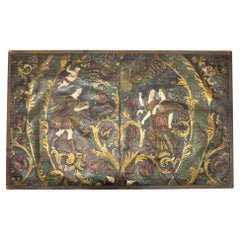
Rare early Embossed gilt leather, mythological hunting scene.
By Jean-Pierre Hamer
Located in ZWIJNDRECHT, NL
Publisher: Jacob & Abraham Hamer, “De Gecroonde Son” Amsterdam
Place / Date: Amsterdam, ca. 1660
Two original 17th c. pendant panels of 'verheven leer' or gilt embossed leather [t...
Category
Antique 17th Century Dutch Dutch Colonial Contemporary Art
Materials
Leather
You May Also Like
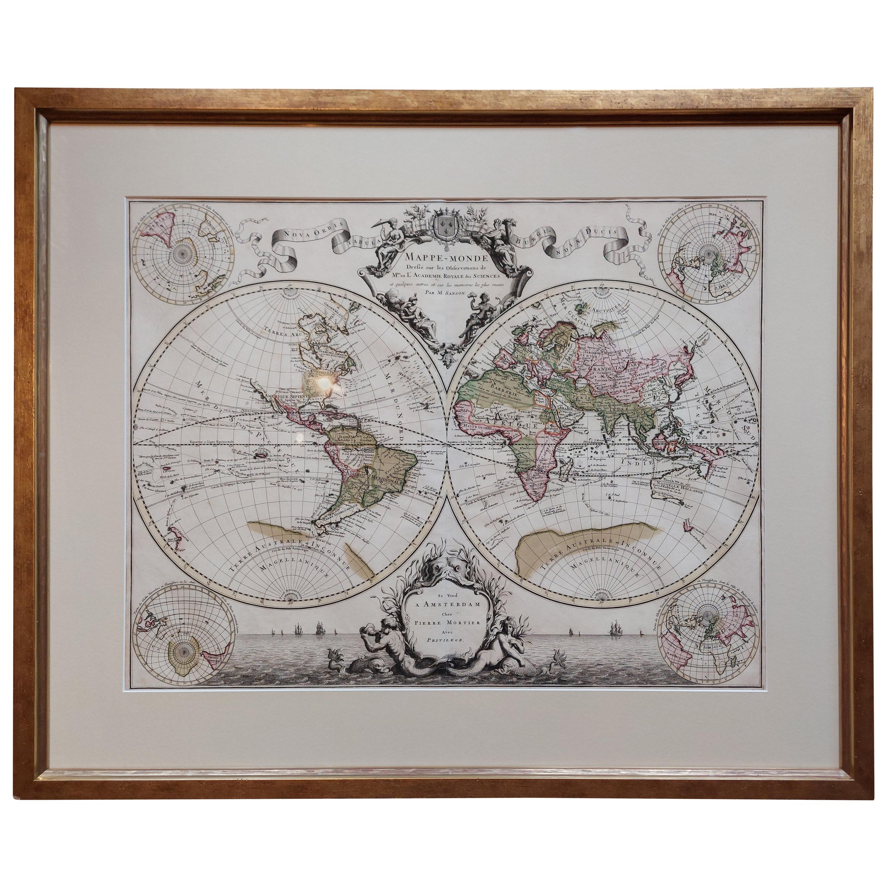
Original Antique Hand-colored World Map with or without Frame, '1696'
Located in Langweer, NL
Antique world map titled 'Mappe-Monde dressee sur les Observations de Mrs. de l'Academie Royale des Sciences (..)'. Beautiful original antique world map...
Category
Antique Late 17th Century Maps
Materials
Paper

$4,313 Sale Price
20% Off
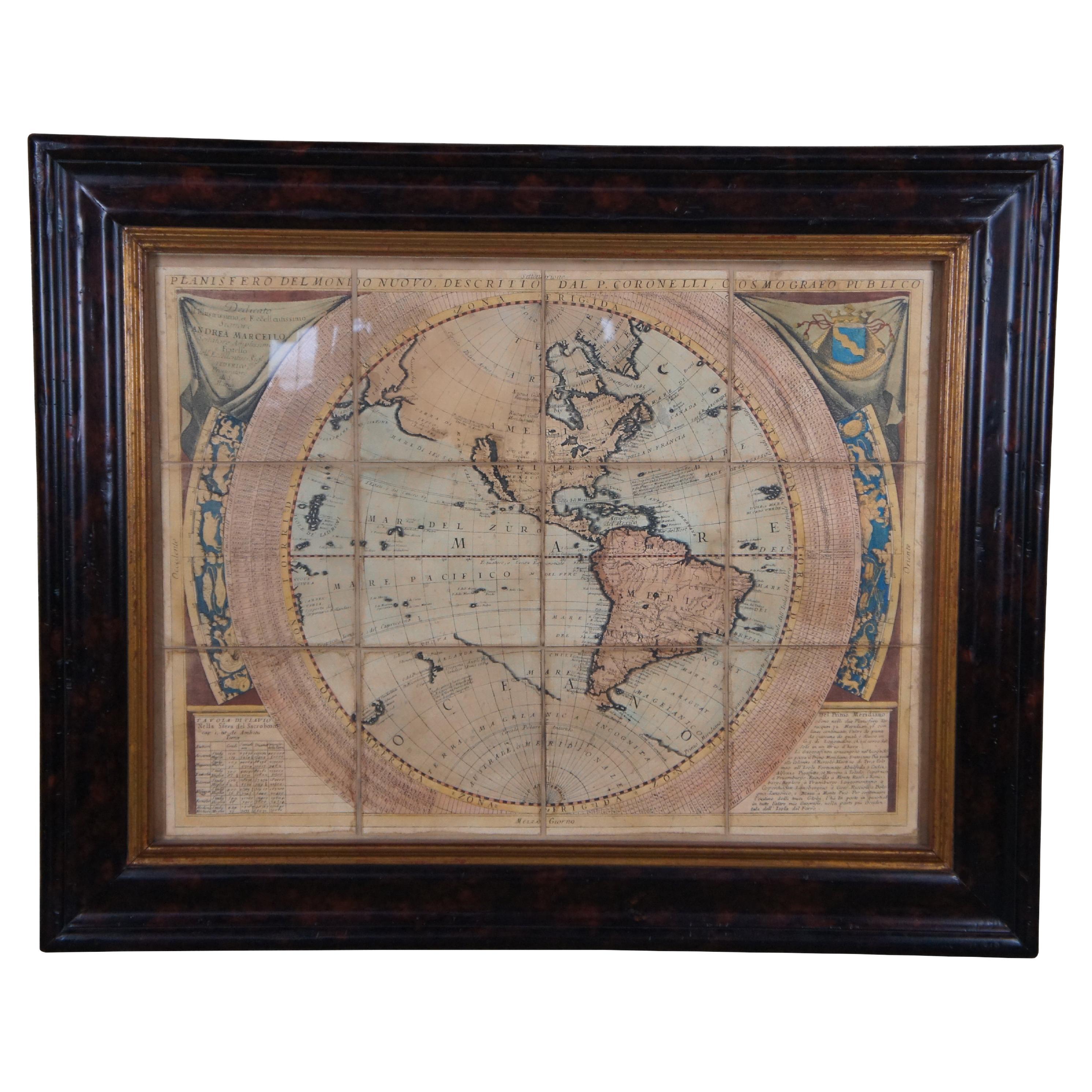
Vincenzo Coronelli's Colored Map of the New World Western Hemisphere Framed 47"
By Vincenzo Coronelli
Located in Dayton, OH
A Framed Reproduction of Coronelli's Map of the New World, Attributed to Trevor James Company. The map shows the Western Hemisphere including the discoveries made by Abel Tasman in A...
Category
20th Century Maps
Materials
Paper

$1,080 Sale Price
20% Off
Antique World Map by P. Schenk '1706'
By Peter Schenk
Located in Langweer, NL
Antique map titled 'Diversa Orbis Terrae. Visu Incedente per Coluros Tropicorum, Ambos Ejus Polos, et Parciularis Sphaerae Zenith, in Planum Orthographica Projectio (..) Plat Ontwerp van verscheyde Aert-klooten (..)'. One of the earliest Dutch World Maps to focus on a more modern cartographic style, based on Carel Allard's map of 1696. This map represented a noteworthy shift from the traditional decorative Dutch 17th century maps where the margins would be full of classical mythological...
Category
Antique Early 18th Century Maps
Materials
Paper

$5,175 Sale Price
20% Off
Vintage Reproduction 17th Century Map of Europe, American, Cartography, Blaeuw
Located in Hele, Devon, GB
This is a vintage reproduction map of Europe. An American, paper stock cartography print in frame after the work by Blaeuw, dating to the late 20t...
Category
Late 20th Century Central American Mid-Century Modern Maps
Materials
Glass, Wood, Paper

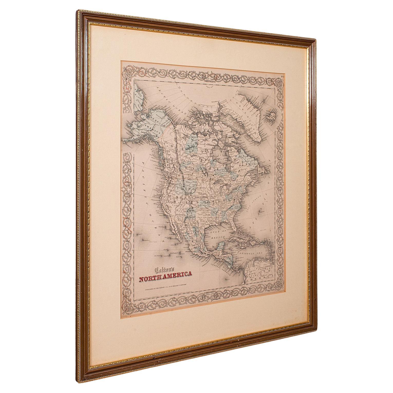
Antique North America Map, USA, Canada, Mexico, Cartography, Colton, Victorian
Located in Hele, Devon, GB
This is an antique North America map. A USA, framed lithography atlas engraving of the continent by JH Colton, dating to the Victorian period and later, circa 1860.
Fascinating, large framed map...
Category
Antique Mid-19th Century American Victorian Maps
Materials
Paper

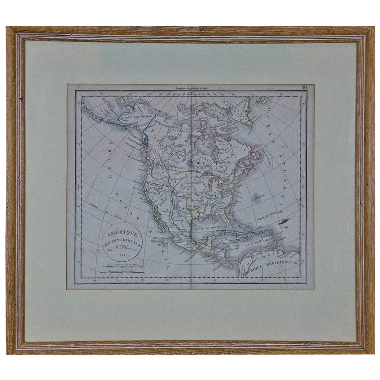
America "Amérique Septentrionale": A 19th Century French Map by Delamarche
By Maison Delamarche 1
Located in Alamo, CA
This framed mid 19th century map of North America entitled "Amérique Septentrionale" by Felix Delamarche was published in Paris in 1854 by Quay de l'Horloge du Palais, avec les Carte...
Category
Antique Mid-19th Century American Other Maps
Materials
Paper

More Ways To Browse
Australian Antiques
Celestial Globe
Antique Celestial Globe
Celestial Sphere
Antique Copper Australia
Celestial Map
Antique Armillary Sphere
Armillary Globe
Vasco Da Gama
Antique Oushak
Mid Century Danish Directors Chairs
Moller 70
Argentina Travel Poster
Century Furniture Faux Bamboo
Early American Chairs
Hans Muller
Vintage Wood Table With Glass Top
19th Century Square Table