Items Similar to Original Antique Hand-colored World Map with or without Frame, '1696'


Want more images or videos?
Request additional images or videos from the seller
1 of 6
Original Antique Hand-colored World Map with or without Frame, '1696'
About the Item
Antique world map titled 'Mappe-Monde dressee sur les Observations de Mrs. de l'Academie Royale des Sciences (..)'. Beautiful original antique world map. Relief shown pictorially. Includes illustrations and 4 small hemispherical polar projections. Appears in Sanson's 'Atlas Nouveau'. Published by P. Mortier, 1696.
- Dimensions:Height: 28.75 in (73 cm)Width: 33.67 in (85.5 cm)Depth: 1.58 in (4 cm)
- Materials and Techniques:
- Period:Late 17th Century
- Date of Manufacture:1696
- Condition:Map is in great condition, with original/contemporary hand coloring. Beautiful gold frame included, minor wear. Please study images carefully.
- Seller Location:Langweer, NL
- Reference Number:
About the Seller
5.0
Platinum Seller
These expertly vetted sellers are 1stDibs' most experienced sellers and are rated highest by our customers.
Established in 2009
1stDibs seller since 2017
1,916 sales on 1stDibs
Typical response time: <1 hour
- ShippingRetrieving quote...Ships From: Langweer, Netherlands
- Return PolicyA return for this item may be initiated within 14 days of delivery.
More From This SellerView All
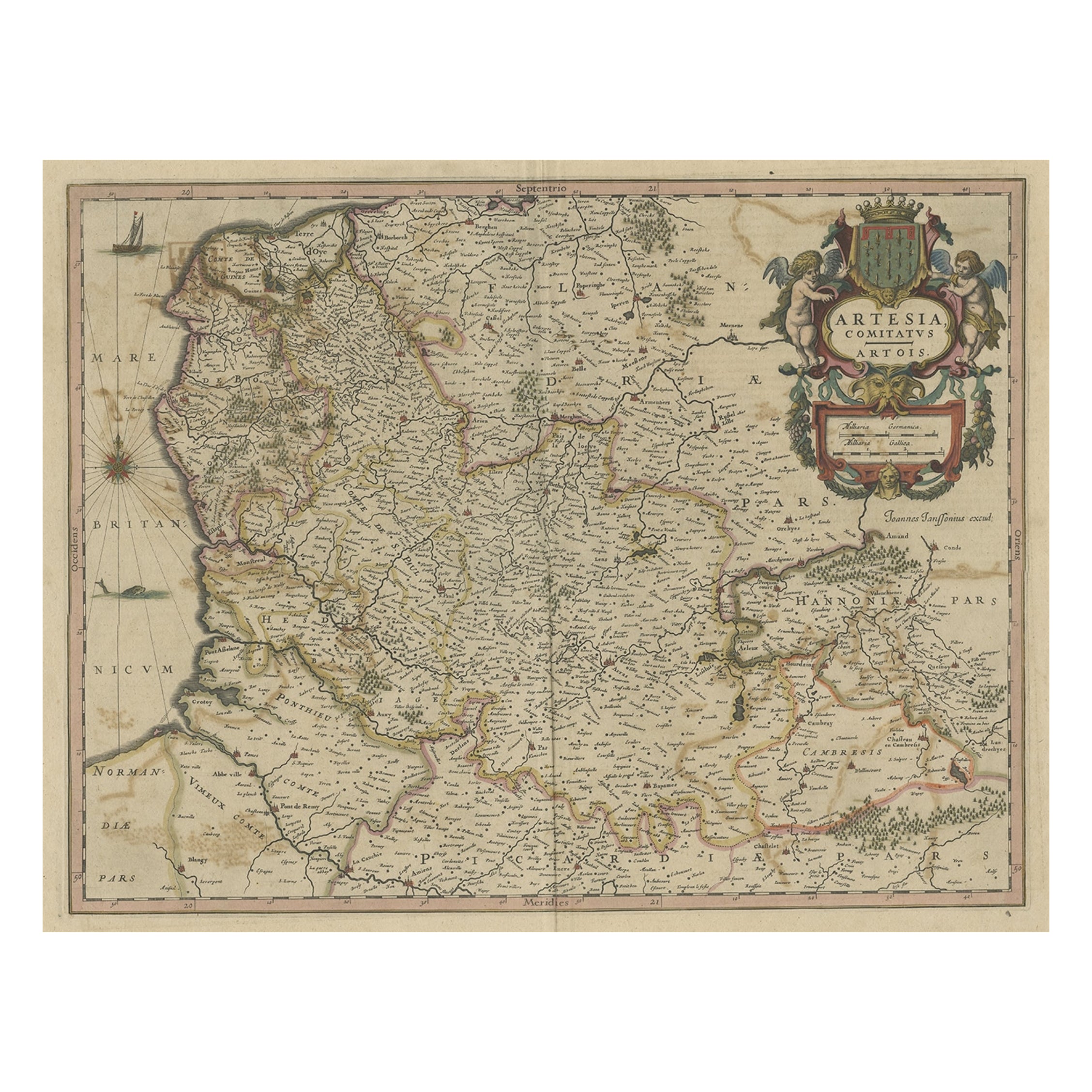
- Original Hand-Colored Antique Map of Artois or Artesia, France, ca.1650Located in Langweer, NLAntique map titled 'Artesia Comitatus Artois'. Map of Artois or Artesia, France. Artois is former province located in the northwestern part of France, boarding Belgium (Flanders)...Category
Antique 1650s Maps
MaterialsPaper
- Original Hand-Colored Antique Regional Map of Switzerland, 1753Located in Langweer, NLAntique map Switzerland titled 'Territorium Reipublicae liberae Helveticae Scaphusiensis (..)'. Regional map of Switzerland. Artists and En...Category
Antique 1750s Maps
MaterialsPaper
- Original Hand-Colored Antique Map of Africa by Elwe '1792'Located in Langweer, NLAntique map titled 'l'Afrique Divisée en ses Empires, Royaumes, et Etats'. Decorative large map of Africa. The cartography is typical for the 17th century with the Nile originating i...Category
Antique Late 18th Century Maps
MaterialsPaper
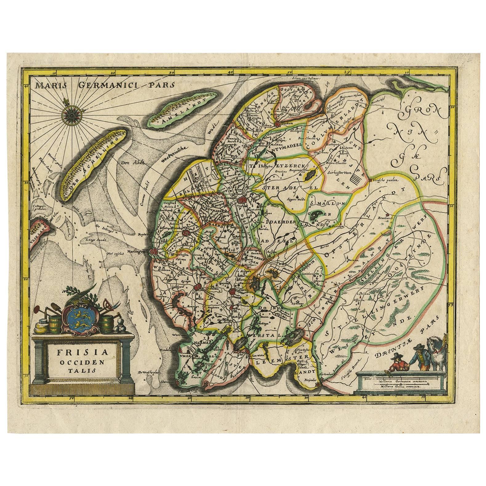
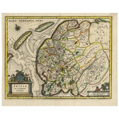
- Original Antique Hand-Colored Map of Friesland by C. Merian, 1659Located in Langweer, NLThis is a hand-colored engraving of the province of Friesland in the Netherlands, created by the Swiss-born engraver and artist Matthäus Merian (1593–1650) and included in "Topograph...Category
Antique Mid-17th Century Maps
MaterialsPaper
- Original Hand-colored Antique Map of Denmark by S. Neele, 1790Located in Langweer, NLAntique very decorative engraving of Denmark engraved by S. Neele. Published in November 1790 by John Trusler. Tape on verso.Category
Antique Late 18th Century Maps
MaterialsPaper
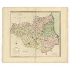
- Original Hand-Colored Antique County Map of Durham, England, 1804Located in Langweer, NLAntique county map of Durham first published c.1800. Villages, towns, and cities illustrated include Gateshead, South Shields, and Darlington. C...Category
Antique Early 1800s Maps
MaterialsPaper


You May Also Like
- South America: Hand-colored 18th Century Framed Map by Thomas JefferysBy Thomas JefferysLocated in Alamo, CAThis detailed hand-colored map of South America by Thomas Jefferys was published in London in 1750. The map shows countries, early colonial possessions, towns, rivers, mountains, and...Category
Antique Mid-18th Century English Maps
MaterialsPaper
- Hand Colored 17th Century Visscher Map "Hollandiae" Southern HollandBy Nicolaes Visscher IILocated in Alamo, CAA hand colored 17th century map of the southern portions of Holland by Nicolaus (Nicolas) Visscher II entitled "Hollandiae pars Meridionalis, vulgo Zuyd-Holland", published in Amsterdam in 1678. The map shows the region between Breda, Heusden, Gornichem, Gouda, Dordrecht, and Willemstad. It includes a decorative cartouche in the lower left corner. The map is presented in an attractive maple colored wood frame with gold trim and a fabric mat. The Visscher family were one of the great cartographic families of the 17th century. Begun by Claes Jansz Visscher...Category
Antique Early 18th Century Dutch Maps
MaterialsPaper
- Northern Scotland: A 16th Century Hand-colored Map by MercatorBy Gerard MercatorLocated in Alamo, CAA framed hand-colored 16th century map of Northern Scotland by Gerard Mercator entitled "Scotiae pars Septentrionalis", published in Amsterdam in 1636. It is a highly detailed map of the northern part of Scotland, with the northwest Highlands and the cities Inverness and Aberdeen, as well as the Orkney Islands and the Hebrides. There is a decorative title cartouche in the upper left corner. The map is presented in an antiqued brown wood...Category
Antique 16th Century Dutch Maps
MaterialsPaper
- Northern Scotland: A 17th Century Hand-colored Map by MercatorBy Gerard MercatorLocated in Alamo, CAThis is a framed hand-colored 17th century map of Northern Scotland by Gerard Mercator entitled "Scotiae pars Septentrionalis", published in Amsterdam in 1636. It is a highly detailed map of the northern part of Scotland, with the northwest Highlands and the cities Inverness and Aberdeen, as well as the Orkney Islands and the Hebrides. There is a decorative title cartouche in the upper left corner. The map is presented in an antiqued brown wood...Category
Antique 1630s Dutch Maps
MaterialsPaper
- "Africa Vetus": a 17th Century Hand-Colored Map by SansonBy Nicolas SansonLocated in Alamo, CAThis original hand-colored copperplate engraved map of Africa entitled "Africa Vetus, Nicolai Sanson Christianiss Galliar Regis Geographi" was originally created by Nicholas Sanson d...Category
Antique Late 17th Century French Maps
MaterialsPaper
- Original Antique Map of Italy. C.1780Located in St Annes, LancashireGreat map of Italy Copper-plate engraving Published C.1780 Unframed.Category
Antique Early 1800s English Georgian Maps
MaterialsPaper


Recently Viewed
View AllMore Ways To Browse
World Relief
Maps Colored
Framed Map
Framed Maps
Antique Map Framed
Antique Maps Framed
Antique Map Framers
Antique Framed Maps
Antique Map Framing
Framed Antique Maps
Framed Antique Map
Framing Antique Maps
Antique Science
17th Century World Map
Antique 17th Century World Map
Map With Relief
Framed World Map
Hemispheres Map