Items Similar to Decorative Antique Map of Central Asia
Want more images or videos?
Request additional images or videos from the seller
1 of 6
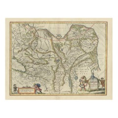
Decorative Antique Map of Central Asia
$373.82
$467.2820% Off
£278.29
£347.8620% Off
€312
€39020% Off
CA$512.04
CA$640.0520% Off
A$569.50
A$711.8820% Off
CHF 297.38
CHF 371.7220% Off
MX$6,930.23
MX$8,662.7820% Off
NOK 3,797.94
NOK 4,747.4320% Off
SEK 3,561.80
SEK 4,452.2520% Off
DKK 2,375.15
DKK 2,968.9320% Off
Shipping
Retrieving quote...The 1stDibs Promise:
Authenticity Guarantee,
Money-Back Guarantee,
24-Hour Cancellation
About the Item
Antique map titled 'Carte de la Tartarie Indépendante (..)'. Decorative map of Central Asia (Tartary). Covers from the Black Sea south to China, north to Russia, and south to Persia and India. Drawn by R. Bonne for Jean Lattre's 'Atlas Moderne' published 1778.
Rigobert Bonne (October 6, 1727 - September 2, 1794) was one of the most important French cartographers of the late 18th century. Bonne was born in Ardennes à Raucourt, France. He taught himself mathematics and by eighteen was a working engineer. During the War of the Austrian Succession (1740 - 1748) he served as a military engineer at Berg-op-Zoom. It the subsequent years Bonne became one of the most respected masters of mathematics, physics, and geography in Paris. In 1773, Bonne succeeded Jacques-Nicolas Bellin as Royal Cartographer to France in the office of the Hydrographer at the Depôt de la Marine. Working in his official capacity, Bonne compiled some of the most detailed and accurate maps of the period - most on an equal-area projection known erroneously as the 'Bonne Projection.' Bonne's work represents an important step in the evolution of the cartographic ideology away from the decorative work of the 17th and early 18th century towards a more scientific and practical aesthetic. While mostly focusing on coastal regions, the work of Bonne is highly regarded for its detail, historical importance, and overall aesthetic appeal. Bonne died of edema in 1794, but his son Charles-Marie Rigobert Bonne continued to publish his work well after his death.
- Dimensions:Height: 14.57 in (37 cm)Width: 19.69 in (50 cm)Depth: 0.02 in (0.5 mm)
- Materials and Techniques:
- Period:
- Date of Manufacture:c.1785
- Condition:Repaired: Several small repairs on worm holes, also affecting image.. General age-related toning. Shows some wear and soiling. Blank verso. Please study image carefully.
- Seller Location:Langweer, NL
- Reference Number:Seller: BG-13512-11stDibs: LU3054335885862
About the Seller
5.0
Recognized Seller
These prestigious sellers are industry leaders and represent the highest echelon for item quality and design.
Platinum Seller
Premium sellers with a 4.7+ rating and 24-hour response times
Established in 2009
1stDibs seller since 2017
2,510 sales on 1stDibs
Typical response time: <1 hour
- ShippingRetrieving quote...Shipping from: Langweer, Netherlands
- Return Policy
Authenticity Guarantee
In the unlikely event there’s an issue with an item’s authenticity, contact us within 1 year for a full refund. DetailsMoney-Back Guarantee
If your item is not as described, is damaged in transit, or does not arrive, contact us within 7 days for a full refund. Details24-Hour Cancellation
You have a 24-hour grace period in which to reconsider your purchase, with no questions asked.Vetted Professional Sellers
Our world-class sellers must adhere to strict standards for service and quality, maintaining the integrity of our listings.Price-Match Guarantee
If you find that a seller listed the same item for a lower price elsewhere, we’ll match it.Trusted Global Delivery
Our best-in-class carrier network provides specialized shipping options worldwide, including custom delivery.More From This Seller
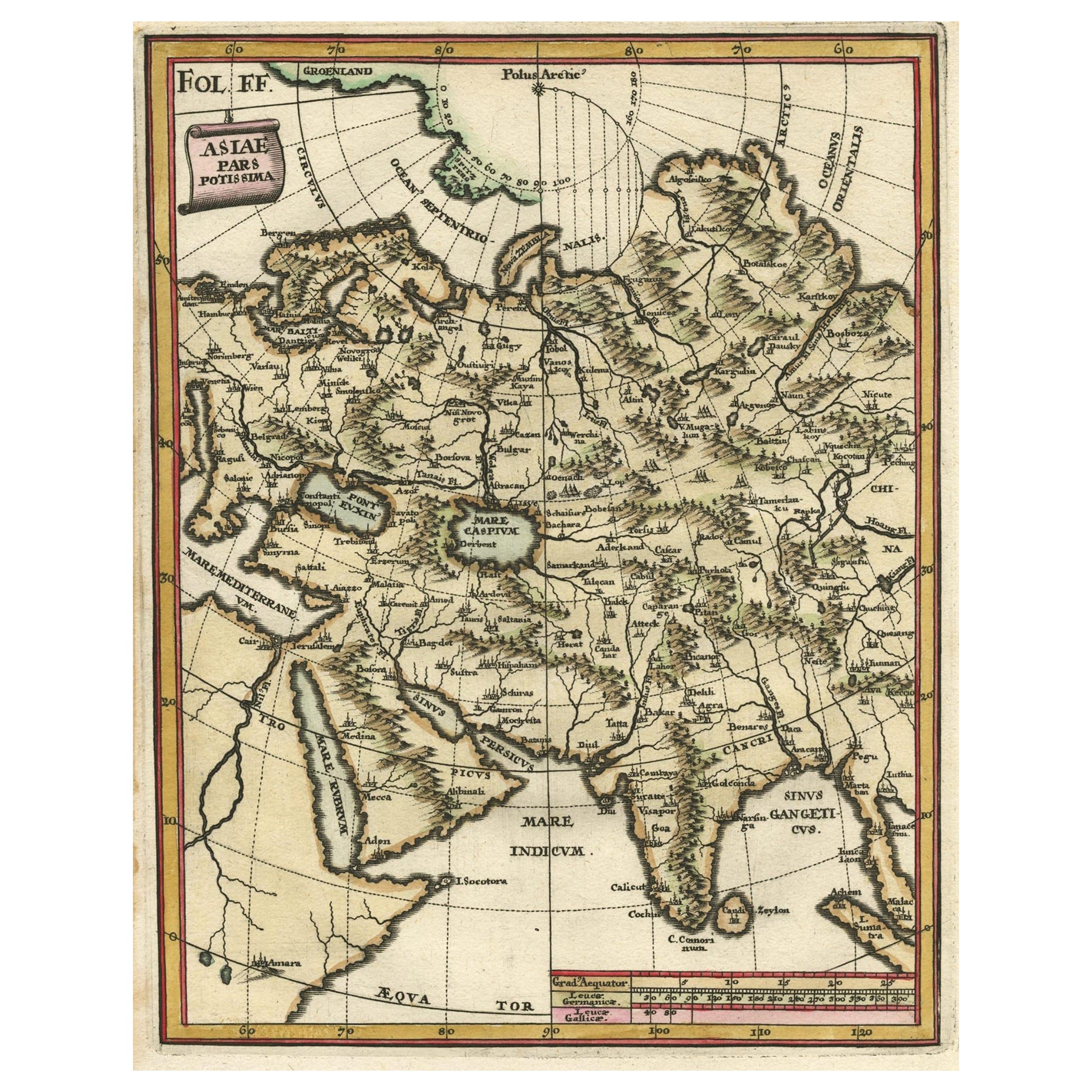
View AllAntique Map of Central Asia Wiht Nova Zembla as an Island, C.1700
Located in Langweer, NL
Antique map titled 'Asiae Pars Potissima.' Attractive map focusing on the central part of Asia but extending to include much of Eastern Europe and Northeastern Africa. The Caspian Se...
Category
Antique 18th Century Maps
Materials
Paper
$527 Sale Price
20% Off
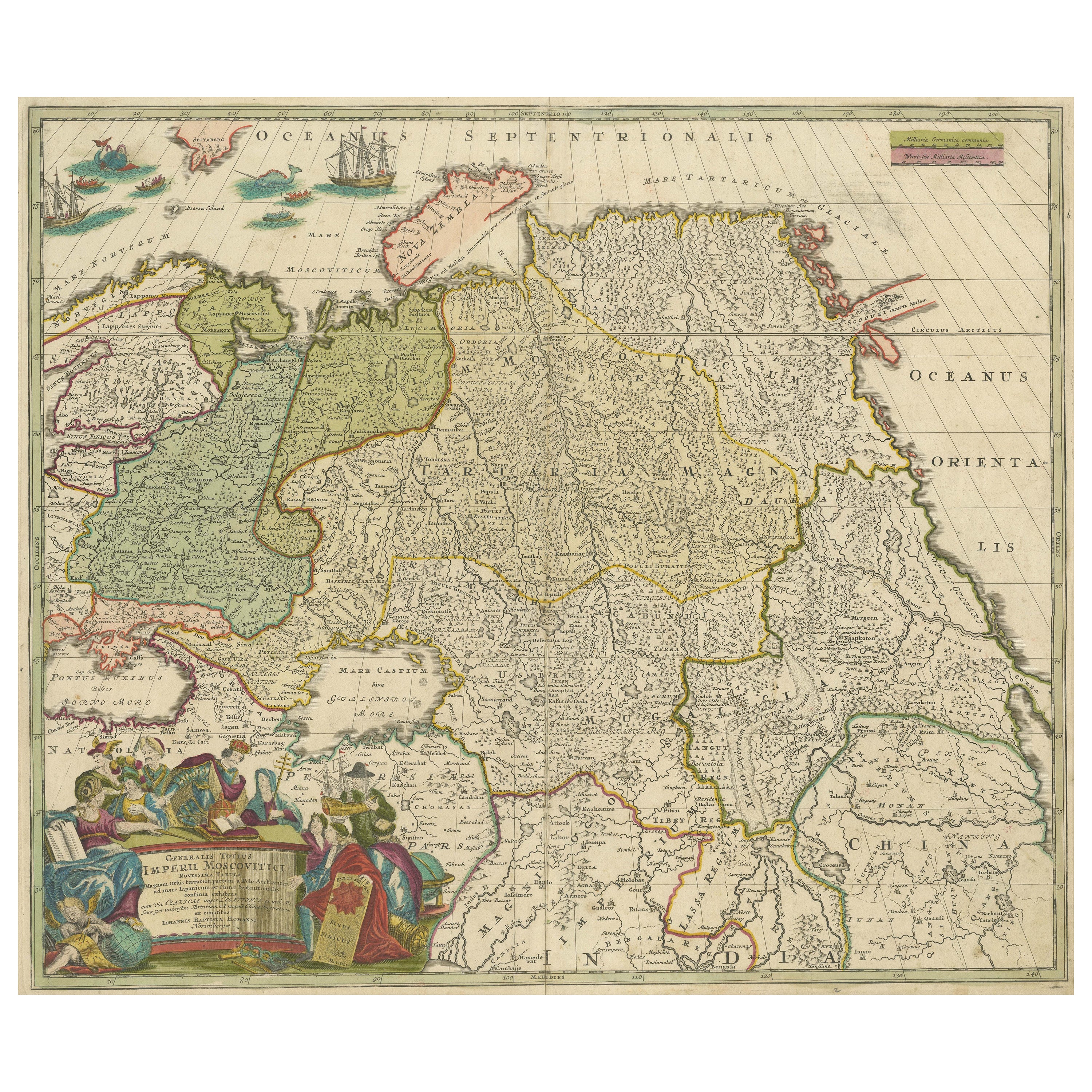
Antique Map of Russia and Central Asia, showing the Northeast Passage
Located in Langweer, NL
Antique map titled 'Generalis Totius Imperii Moscovitici (..)'. Decorative map of Russia and Central Asia, showing the Northeast Passage. The map covers the entirety of the Russian Empire at the time, stretching from the Arctic Circle in the north to the "Oceanus Orientalis" and the northern parts China (Chinae Septentrionalis confinia), Mongolia and India in the south. Published by J.B. Homann, circa 1730.
Johann Baptist Homann was born 1664 in Oberkammlach. He founded his business 1702 in Nuremberg, Germany. After a long period of Dutch domination in map publishing, the Homann publishing house became the most important map...
Category
Antique Mid-18th Century Maps
Materials
Paper
$853 Sale Price
20% Off
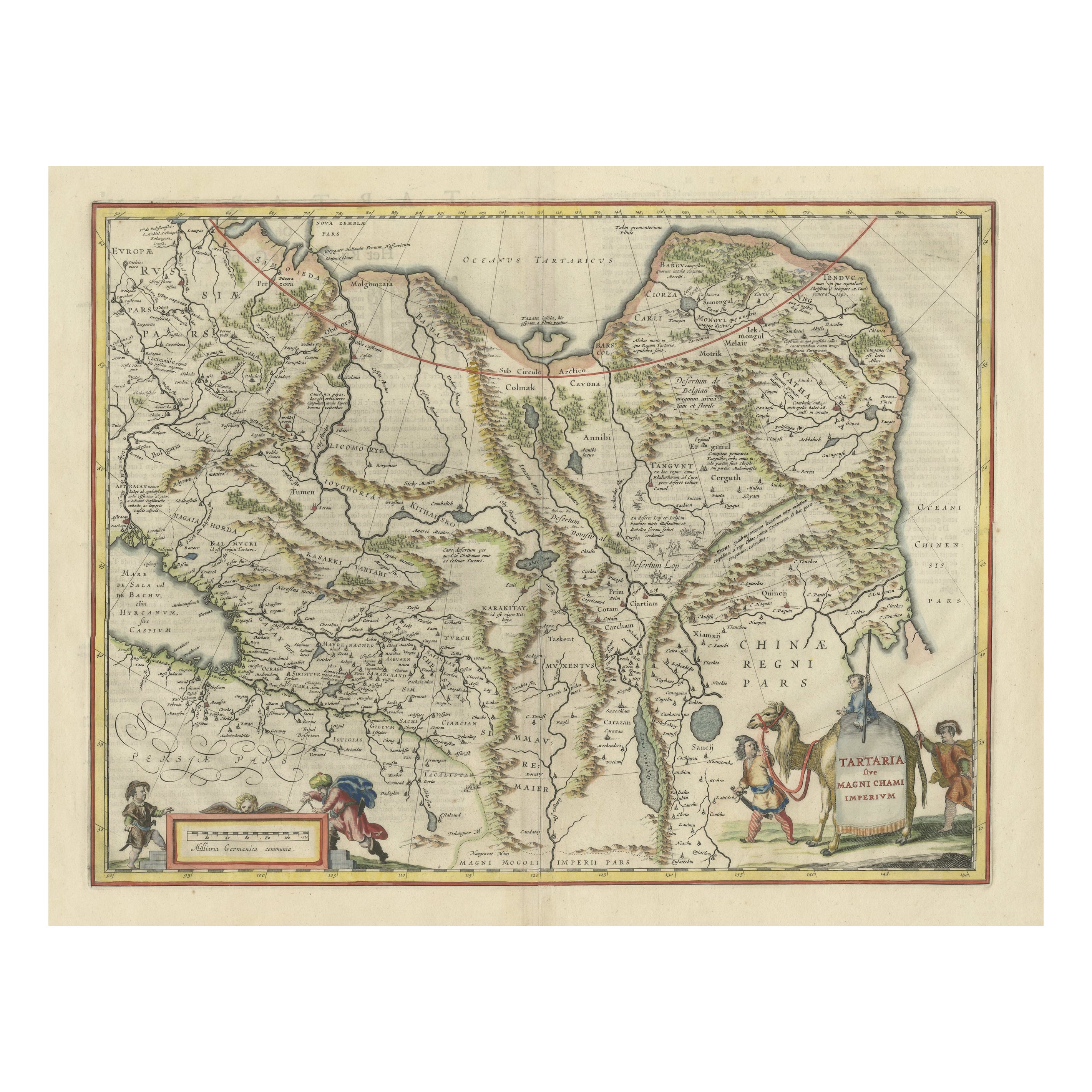
Old Genuine Antique Map of Tartary in the Russian Far East
Located in Langweer, NL
Original antique map titled 'Tartaria sive Magni Chami Imperium'. This great map of Tartary covers all of eastern Asia between the Caspian Sea and northern China and Manchuria. Being...
Category
Antique Mid-17th Century Maps
Materials
Paper
$1,341 Sale Price
20% Off
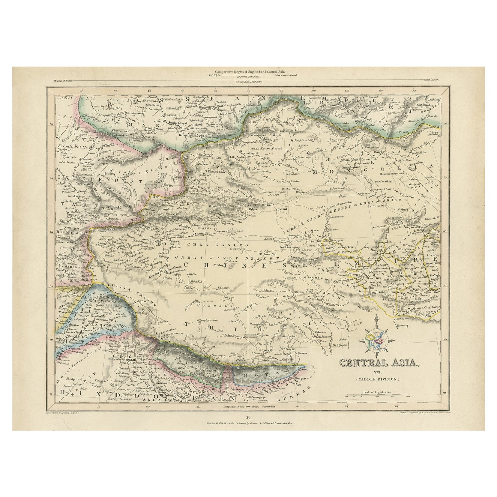
Antique Map of Central Asia, Finely Engraved, 1841
Located in Langweer, NL
Antique map titled 'Central Asia, Middle Division'. A finely engraved and attractive mid 19th Century map of Central Asia which was drawn and engraved by Joshua Archer and published ...
Category
Antique 19th Century Maps
Materials
Paper
$230 Sale Price
20% Off
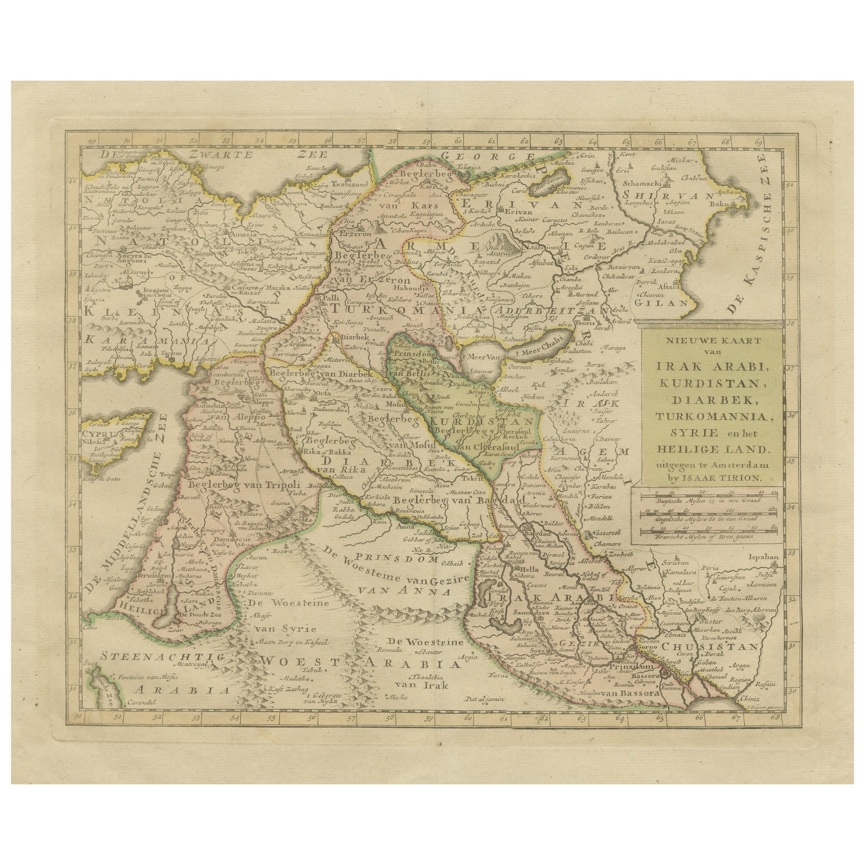
Antique Map of Eastern Turkey, Caucasus, Israel through Iraq and part of Arabia
Located in Langweer, NL
Antique map titled 'Nieuwe Kaart van Irak Arabia, Kurdistan, Diarbek, Turkomannia, Syrie en het Heilige Land'. Beautiful map including eastern Turkey, the Caucasus, Israel through Ir...
Category
Antique Mid-18th Century Maps
Materials
Paper

$440 Sale Price
20% Off
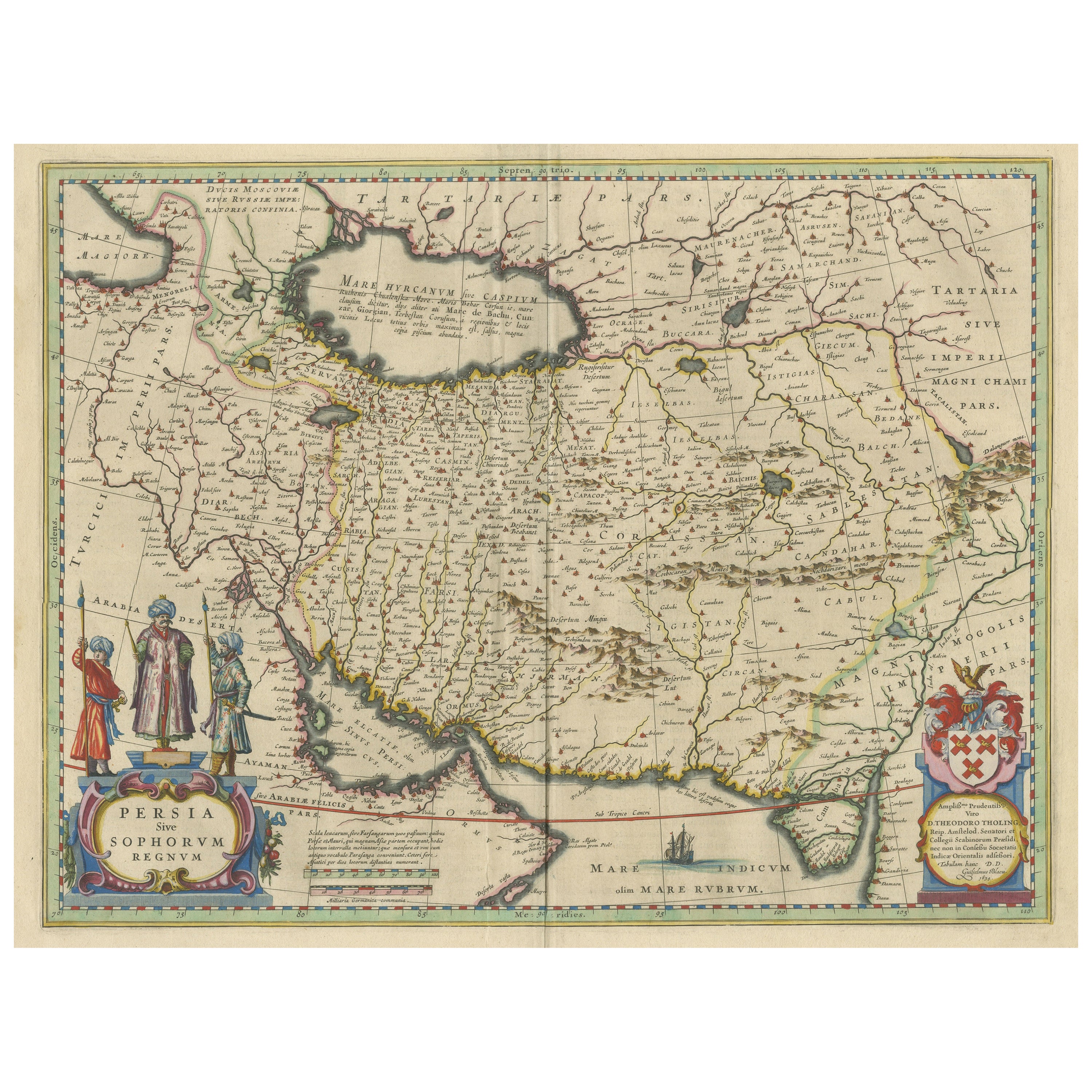
Antique Map of Persia with Dedication Cartouche
Located in Langweer, NL
Antique map titled 'Persia sive Sophorum Regnum'. Original old map of Persia. The map extends from the Eastern Mediteranian to Tacalistan and the Indus River and the Dalanguer Mounta...
Category
Antique Mid-17th Century Maps
Materials
Paper
You May Also Like
Antique French Map of Asia Including China Indoneseia India, 1783
Located in Amsterdam, Noord Holland
Very nice map of Asia. 1783 Dedie au Roy.
Additional information:
Country of Manufacturing: Europe
Period: 18th century Qing (1661 - 1912)
Condition: Overall Condition B (Good Used)...
Category
Antique 18th Century European Maps
Materials
Paper

$648 Sale Price
20% Off
Antique 1803 Italian Map of Asia Including China Indoneseia India
Located in Amsterdam, Noord Holland
Antique 1803 Italian Map of Asia Including China Indoneseia India
Very nice map of Asia. 1803.
Additional information:
Type: Map
Country of Manufacturing: Europe
Period: 19th centu...
Category
Antique 19th Century European Maps
Materials
Paper

$584 Sale Price
20% Off
Persia, Armenia & Adjacent Regions: A 17th Century Hand-colored Map by De Wit
By Frederick de Wit
Located in Alamo, CA
A large 17th century hand colored copperplate engraved map entitled "Novissima nec non Perfectissima Scandinaviae Tabula comprehendens Regnorum Sueciae, Daniae et Norvegiae distincte...
Category
Antique Late 17th Century Dutch Maps
Materials
Paper

Hand-Colored 18th Century Homann Map of the Black Sea, Turkey and Asia Minor
By Johann Baptist Homann
Located in Alamo, CA
An attractive original early 18th century hand-colored map of the Black Sea and Turkey entitled "Carte de L'Asie Minevre ou de la Natolie et du Pont Evxin Tiree des Voyages et des Ob...
Category
Antique Early 18th Century German Maps
Materials
Paper

17th Century Nicolas Visscher Map of Southeastern Europe
Located in Hamilton, Ontario
A beautiful, highly detailed map of southeastern Europe by Nicolas Visscher. Includes regions of Northern Italy (showing the cities Bologna, Padua, and Venice), Bohemia, Austria (sho...
Category
Antique 17th Century Dutch Maps
Materials
Paper

$1,350 Sale Price
38% Off
1790 Thomas Stackhouse Map, Entitled "Russia in Europe, " , Ric.a004
Located in Norton, MA
1790 Thomas Stackhouse map, entitled
"Russia in Europe"
Ric.a004
Stackhouse, Thomas
Russia in Europe [map]
London: T. Stackhouse, 1783. Map. Matted hand-colored copper engraving. Image size: 14.5 x 15.25 inches. Mat size: 22.75 x 23.75 inches. A beautiful example of this map of Eastern Europe...
Category
Antique 17th Century Unknown Maps
Materials
Paper

More Ways To Browse
Antique Austrian China
Giacometti Chairs
Antique Rug Wool Navy Blue Red
Bauhaus Flower Stand
French Table With Drawers
North Carolina Furniture
Antique Silver Platter
Boat Blueprint
Cream Plates
Vintage Art Deco Rugs
Vintage Serving Forks
Brewery Signs
Herati Rug
Venice Wood
Gold Leaf Furniture Black
Italian Wood Console Tables
Maison Jansen Argentina
Antique Oushak