Items Similar to Detailed 1729 Battle Map – Allied Army Camp at Denain France, 1712 Siege

Video Loading
Want more images or videos?
Request additional images or videos from the seller
1 of 11
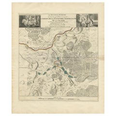
Detailed 1729 Battle Map – Allied Army Camp at Denain France, 1712 Siege
$524.11
£397.03
€450
CA$726.09
A$814.35
CHF 426.46
MX$9,895.19
NOK 5,415.38
SEK 5,134.16
DKK 3,426.19
About the Item
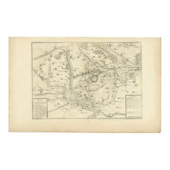
Map of Allied Camp at Denain, France, 1712 Attack – Published 1729
This engraved map depicts the army camp of the Allied forces at Denain, attacked by the French on July 24, 1712 during the War of the Spanish Succession. The title reads: Plan van het Campement en de Retrenchmenten der Geallieerden by Denain, meaning Plan of the Camp and Retrenchments of the Allies at Denain. It was published in 1729 as part of the second volume of the Dutch edition of Jean du Mont’s Krygs-overgeschiedenissen (Military Histories), under Tom. II. No. 58\*. This large, detailed plan illustrates the positions of regiments, entrenchments, artillery placements, river crossings, and the layout of the fortified camp. The legend below provides an extensive key identifying over 30 different features, including headquarters of Prince Eugene of Savoy and various lines of defense.
The Battle of Denain was a decisive engagement where French forces under Marshal Villars defeated the Allies, reversing their earlier successes and leading to the Treaty of Utrecht in 1713. This map reflects the strategic complexity of early 18th-century warfare, with detailed troop arrangements and fortifications. Such maps were used for both military education and historical record, and are now valued for their historical significance and decorative appeal.
The engraving was likely produced by Leonard Schenk or Pieter Schenk in Amsterdam, known for publishing military maps and atlases. The clear linework and detailed layout are characteristic of their workshop.
Condition report:
Very good condition. Strong impression with clear details. Light general age toning and minimal scattered foxing, mainly outside the printed area. Original center fold as issued. Wide margins with slight handling wear at edges.
Framing suggestion:
Frame with a simple dark wood or black frame and an archival cream or off-white mat to highlight the engraving. Use UV-protective glass to preserve the paper and avoid further toning.
- Dimensions:Height: 20.87 in (53 cm)Width: 23.23 in (59 cm)Depth: 0.01 in (0.2 mm)
- Materials and Techniques:Paper,Engraved
- Place of Origin:
- Period:
- Date of Manufacture:circa 1729
- Condition:Very good condition. Strong impression with clear details. Light general age toning and minimal scattered foxing, mainly outside the printed area. Original center fold as issued. Wide margins with slight handling wear at edges.
- Seller Location:Langweer, NL
- Reference Number:Seller: BG-13201-11stDibs: LU3054345716632
About the Seller
5.0
Recognized Seller
These prestigious sellers are industry leaders and represent the highest echelon for item quality and design.
Platinum Seller
Premium sellers with a 4.7+ rating and 24-hour response times
Established in 2009
1stDibs seller since 2017
2,516 sales on 1stDibs
Typical response time: <1 hour
- ShippingRetrieving quote...Shipping from: Langweer, Netherlands
- Return Policy
Authenticity Guarantee
In the unlikely event there’s an issue with an item’s authenticity, contact us within 1 year for a full refund. DetailsMoney-Back Guarantee
If your item is not as described, is damaged in transit, or does not arrive, contact us within 7 days for a full refund. Details24-Hour Cancellation
You have a 24-hour grace period in which to reconsider your purchase, with no questions asked.Vetted Professional Sellers
Our world-class sellers must adhere to strict standards for service and quality, maintaining the integrity of our listings.Price-Match Guarantee
If you find that a seller listed the same item for a lower price elsewhere, we’ll match it.Trusted Global Delivery
Our best-in-class carrier network provides specialized shipping options worldwide, including custom delivery.More From This Seller
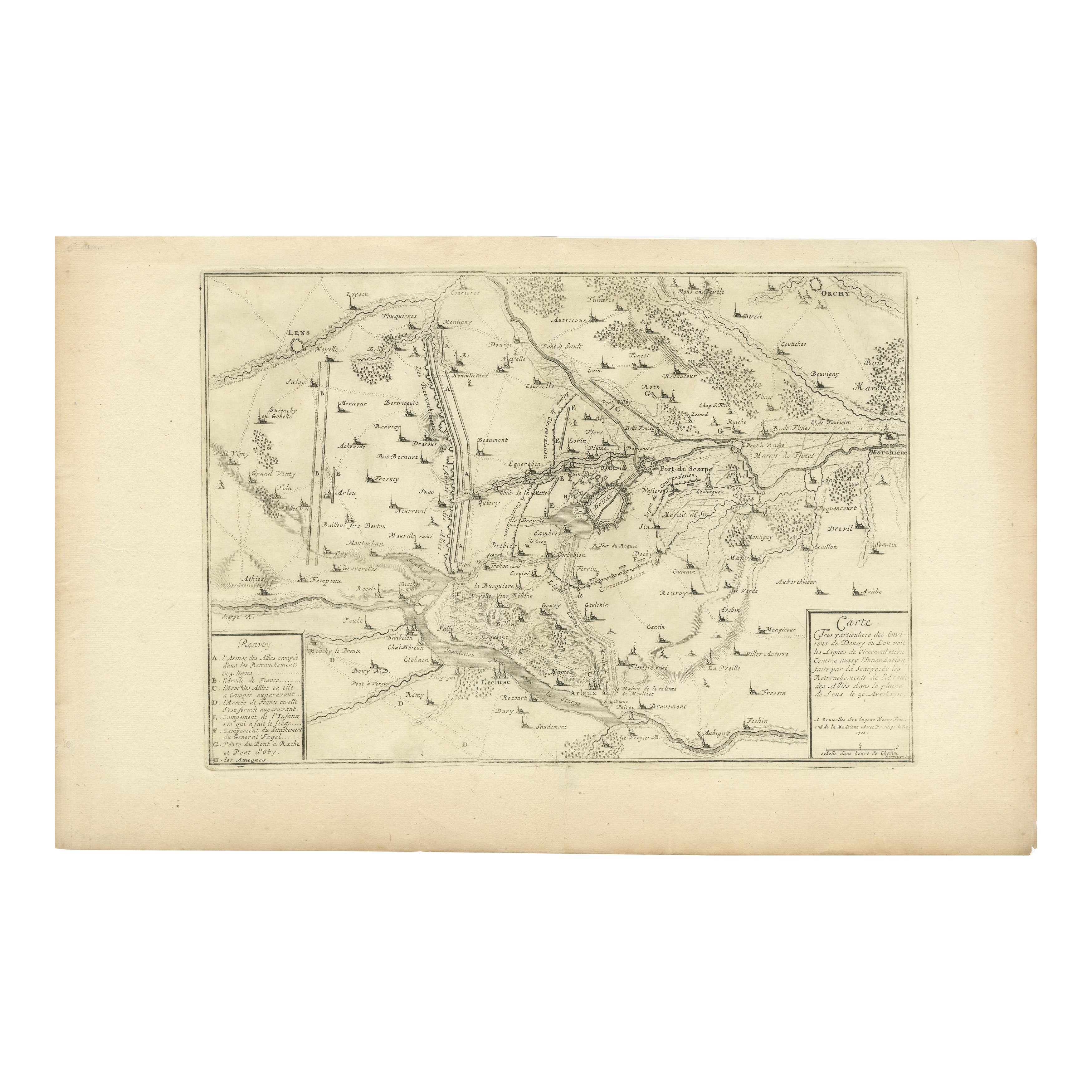
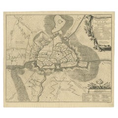
View AllDetailed 1720s Map – Siege of Douay and Lines of Circumvallation, France
Located in Langweer, NL
Detailed 1720s Map – Siege of Douay and Lines of Circumvallation, France
This engraved map shows the detailed fortifications and surrounding region of Douay (Douai) in northern Fran...
Category
Antique Early 18th Century French Maps
Materials
Paper
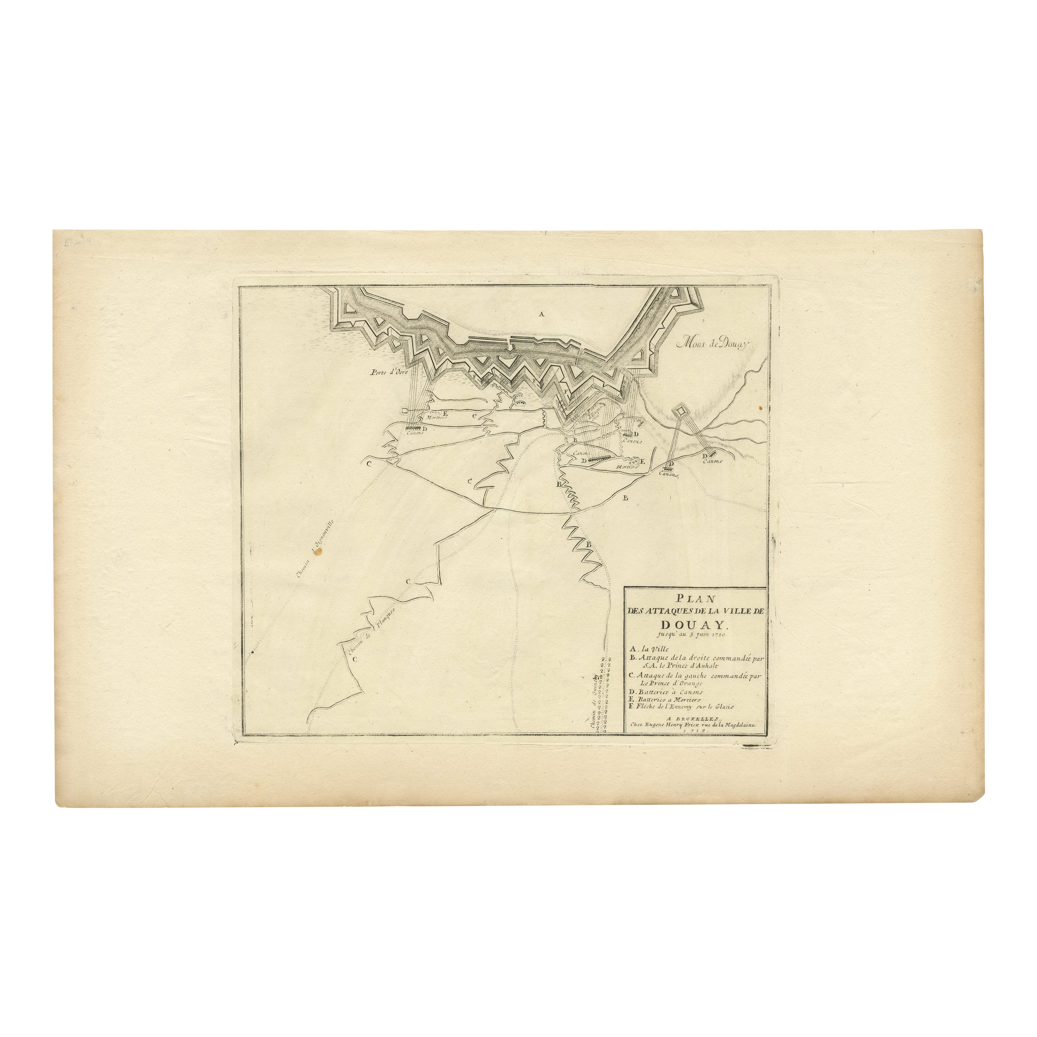
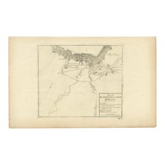
Attack Plan of Douay Fortress, France, 1710 Siege – Brussels c.1720 Map
Located in Langweer, NL
Attack Plan of Douay Fortress, France, 1710 Siege – Brussels c.1720 Map
This engraved military map shows the detailed plan of attacks on the fortress city of Douay (Douai) in northe...
Category
Antique Early 18th Century French Maps
Materials
Paper
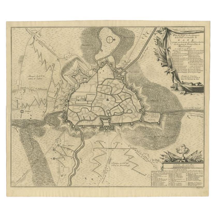
Antique Map of the Siege of Gent by Dumont, 1729
By Dumont
Located in Langweer, NL
Antique map titled 'Plan of the Siege and Attacks of the City and Citadel of Ghent'. Large map depicting the siege of the Belgian city of Gent in 1708 during the war of the Spanish S...
Category
Antique 18th Century Maps
Materials
Paper
$312 Sale Price
20% Off
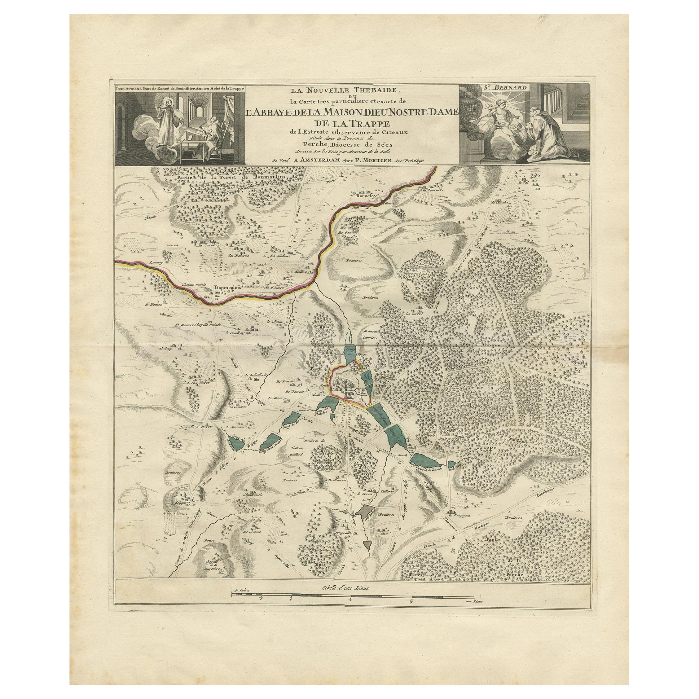
Antique Map of the Area around the Abbey in Soligny-la-Trappe 'c.1710'
Located in Langweer, NL
Antique map titled 'La nouvelle Thebaide ou la Carte tres particuliere et exacte de l'Abbaye de la Maison Dieu Nostre Dame de la Trappe (..)'. Rare, original map of the area around t...
Category
Antique Early 18th Century Maps
Materials
Paper
$745 Sale Price
20% Off
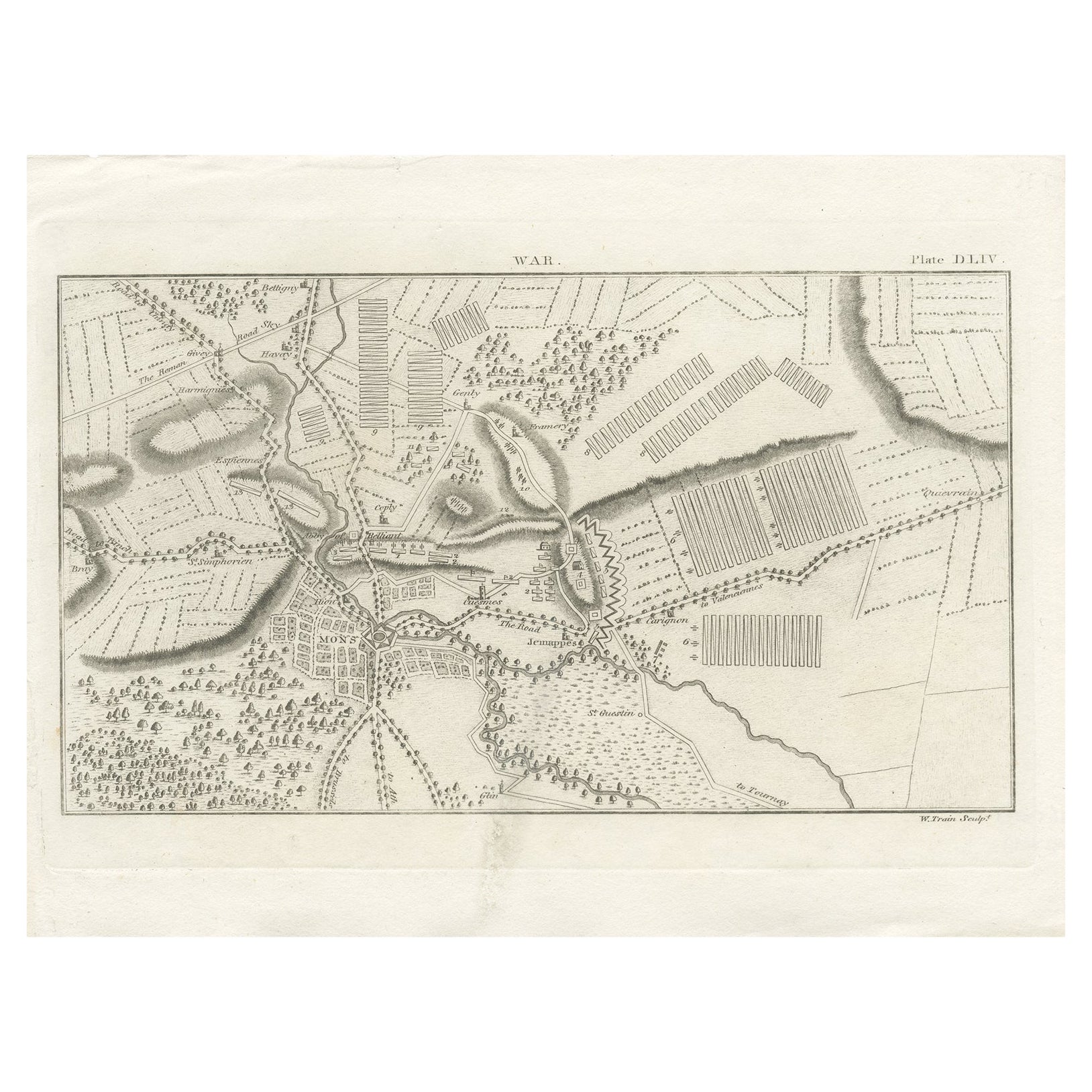
Antique War Map of the Region of Mons 'Bergen', Belgium, circa 1810
Located in Langweer, NL
Antique print titled 'Plate DLIV War'. Old print depicting a war map of the region of Mons (Bergen), Belgium. This print originates from 'Encyclopedia Britannica'.
Artists and En...
Category
Antique 19th Century Prints
Materials
Paper
$121 Sale Price
20% Off
Antique Map of Boulogne-sur-Mer by Bellin '1764'
Located in Langweer, NL
Antique map titled 'Plan de la Ville de Boulogne'. Original antique map of Boulogne-sur-Mer, France. This map originates from 'Le petit atlas maritime: recueil de cartes et plans des...
Category
Antique Mid-18th Century Maps
Materials
Paper

$139 Sale Price
20% Off
You May Also Like
1657 Janssonius Map of Vermandois and Cappelle, Ric. A-004
Located in Norton, MA
1657 Janssonius map of
Vermandois and Cappelle
Ric.a004
Description: Antique map of France titled 'Descriptio Veromanduorum - Gouvernement de la Cappelle'. Two detailed maps o...
Category
Antique 17th Century Unknown Maps
Materials
Paper

Map of Battle of Smolensk - Etching by Pierre François Tardieu - 1837
Located in Roma, IT
Map of Battle of Smolensk is an Etching realized by Pierre François Tardieu in 1837.
Good conditions.
The artwork is realized in a well-balanced composition. the artwork and belong...
Category
1830s Modern Figurative Prints
Materials
Lithograph
17th-18th Century Siege of Graves Mapping Engraving By Willian III
Located in Kingston, NY
RARE French 17th-18th Century Enhanced Siege of Graves Mapping Engraving BY William III, also widely known as William of Orange,
The Siege of Grave in Dutch Brabant started by Monsie...
Category
Antique 17th Century French Prints
Materials
Paper

1771 Bonne Map of Poitou, Touraine and Anjou, France, Ric.a015
Located in Norton, MA
1771 Bonne Map of Poitou,
Touraine and Anjou, France
Ric.a015
1771 Bonne map of Potiou, Touraine and Anjou entitled "Carte des Gouvernements D'Anjou et du Saumurois, de la Touraine, du Poitou,du Pays d'aunis, Saintonge?Angoumois,"
Carte des gouvernements d'Anjou et du Saumurois, de la Touraine, du Poitou, du Pays d'Aunis, Saintonge-Angoumois. Projettee et assujettie au ciel par M. Bonne, Hyd. du Roi. A Paris, Chez Lattre, rue St. Jacques a la Ville de Bord(ea)ux. Avec priv. du Roi. 1771. Arrivet inv. & sculp., Atlas moderne ou collection de cartes sur toutes...
Category
Antique 17th Century Unknown Maps
Materials
Paper

Original Antique Map or City Plan of Geneva, Switzerland. Circa 1835
Located in St Annes, Lancashire
Nice map of Geneva
Drawn and engraved by J.Dower
Published by Orr & Smith. C.1835
Unframed.
Free shipping
Category
Antique 1830s English Maps
Materials
Paper

1752 Vaugoundy Map of Flanders : Belgium, France, and the Netherlands, Ric.a002
Located in Norton, MA
Large Vaugoundy Map of Flanders:
Belgium, France, and the Netherlands
Colored -1752
Ric.a002
Description: This is a 1752 Didier Robert de Vaugondy map of Flanders. The map de...
Category
Antique 17th Century Unknown Maps
Materials
Paper

More Ways To Browse
Foldable Military
Engraving Battle
Siege Antique
Dutch Military
Prince Eugene
Curved Velvet Couch
Velvet Curved Sofa
Wood Round Coffee Tables
Oak Brutalist
Used College Furniture
Wood Minimalist Chair
Antique Imperial Furniture
Gold Modern Coffee Table
Large Side Tables
18th Century Gilded Furniture
Fluted Column
Japanese Silver Ceramics
One Of A Kind Chair