Items Similar to Antique War Map of the Region of Mons 'Bergen', Belgium, circa 1810


Want more images or videos?
Request additional images or videos from the seller
1 of 6
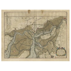
Antique War Map of the Region of Mons 'Bergen', Belgium, circa 1810
About the Item
Antique print titled 'Plate DLIV War'. Old print depicting a war map of the region of Mons (Bergen), Belgium. This print originates from 'Encyclopedia Britannica'.
Artists and Engravers: Engraved by W. Train.
Condition: Good, general age-related toning. Please study image carefully.
Date: c.1810
Overall size: 26.5 x 20.3 cm.
Image size: 24.2 x 14.1 cm.
Antique prints have long been appreciated for both their aesthetic and investment value. They were the product of engraved, etched or lithographed plates. These plates were handmade out of wood or metal, which required an incredible level of skill, patience and craftsmanship. Whether you have a house with Victorian furniture or more contemporary decor an old engraving can enhance your living space. We offer a wide range of authentic antique prints for any budget.
- Dimensions:Height: 8 in (20.3 cm)Width: 10.44 in (26.5 cm)Depth: 0 in (0.01 mm)
- Materials and Techniques:
- Period:
- Date of Manufacture:circa 1810
- Condition:Condition: Good, general age-related toning. Please study image carefully.
- Seller Location:Langweer, NL
- Reference Number:
About the Seller
5.0
Platinum Seller
These expertly vetted sellers are 1stDibs' most experienced sellers and are rated highest by our customers.
Established in 2009
1stDibs seller since 2017
1,933 sales on 1stDibs
Typical response time: <1 hour
- ShippingRetrieving quote...Ships From: Langweer, Netherlands
- Return PolicyA return for this item may be initiated within 14 days of delivery.
More From This SellerView All
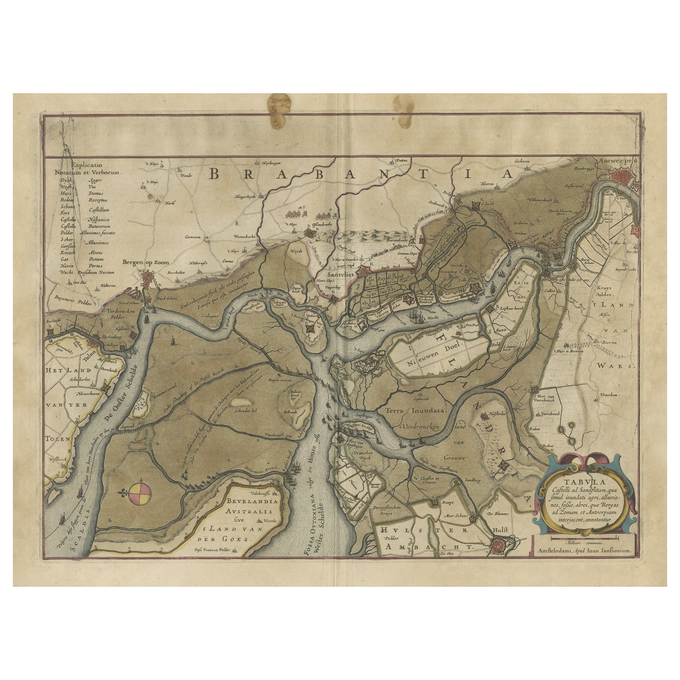
- Antique Map of the region between Bergen op Zoom, Sandvliet, Hulst and AntwerpLocated in Langweer, NLOriginal antique map titled 'Tabula Castelli ad Sandflitam (..)'. Detailed map of the region between Bergen op Zoom, Sandvliet, Hulst and Antwerp. Published by J. Janssonius, circa 1...Category
Antique Mid-17th Century Maps
MaterialsPaper
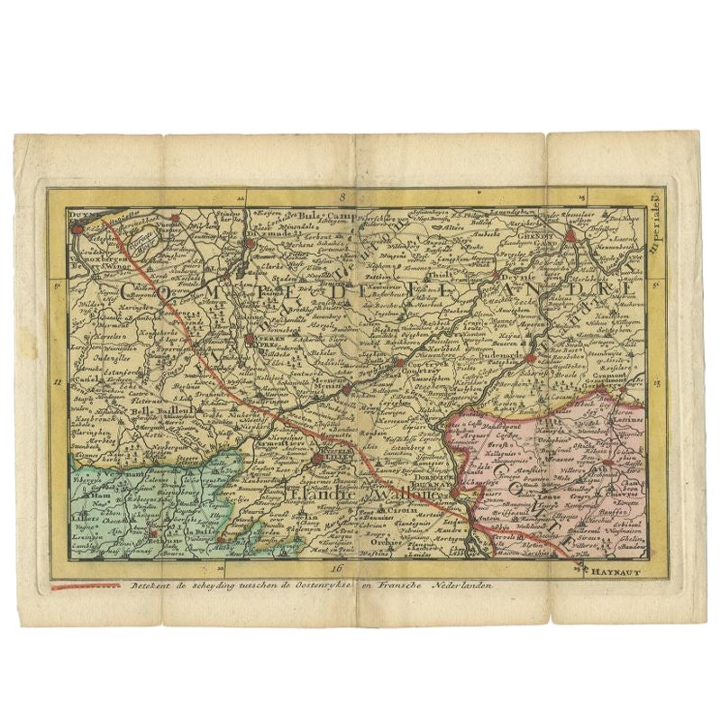
- Antique Map of the Region of Flanders in Belgium, 1737Located in Langweer, NLUntitled map of the region of Flanders, Belgium. This map originates from 'Nieuw en beknopt Kaart-Boekje vertoonende de XVII. Nederlandse Provintien (..)'. Artists and Engravers: A...Category
Antique 18th Century Maps
MaterialsPaper
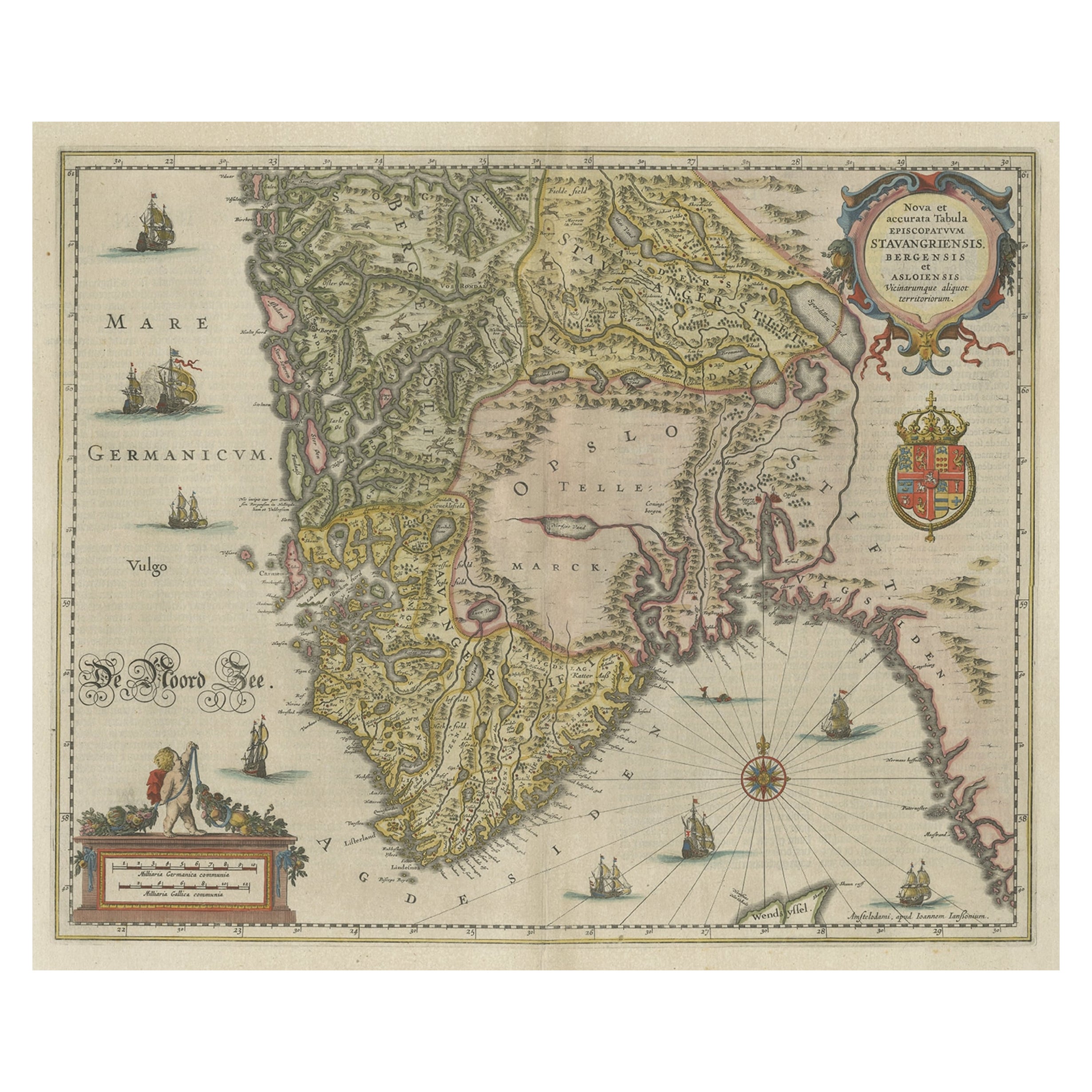
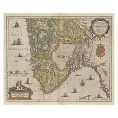
- Old Map of The Southern Part of Norway, Covering the Region Around Bergen, c1650Located in Langweer, NLAntique map titled 'Nova et Accurata Tabula Episcopatuum Stavangriensis et Asloiensis'. Old map of the southern part of Norway, it covers the region around Bergen. Decorated with...Category
Antique 1650s Maps
MaterialsPaper
- Antique Map of the Vermandois Region by Janssonius, circa 1650By Johannes JanssoniusLocated in Langweer, NLAntique map titled 'Vermandois'. Old map of the Vermandois region, France. Vermandois was a French County that appeared in the Merovingian period. Its na...Category
Antique Mid-17th Century Maps
MaterialsPaper
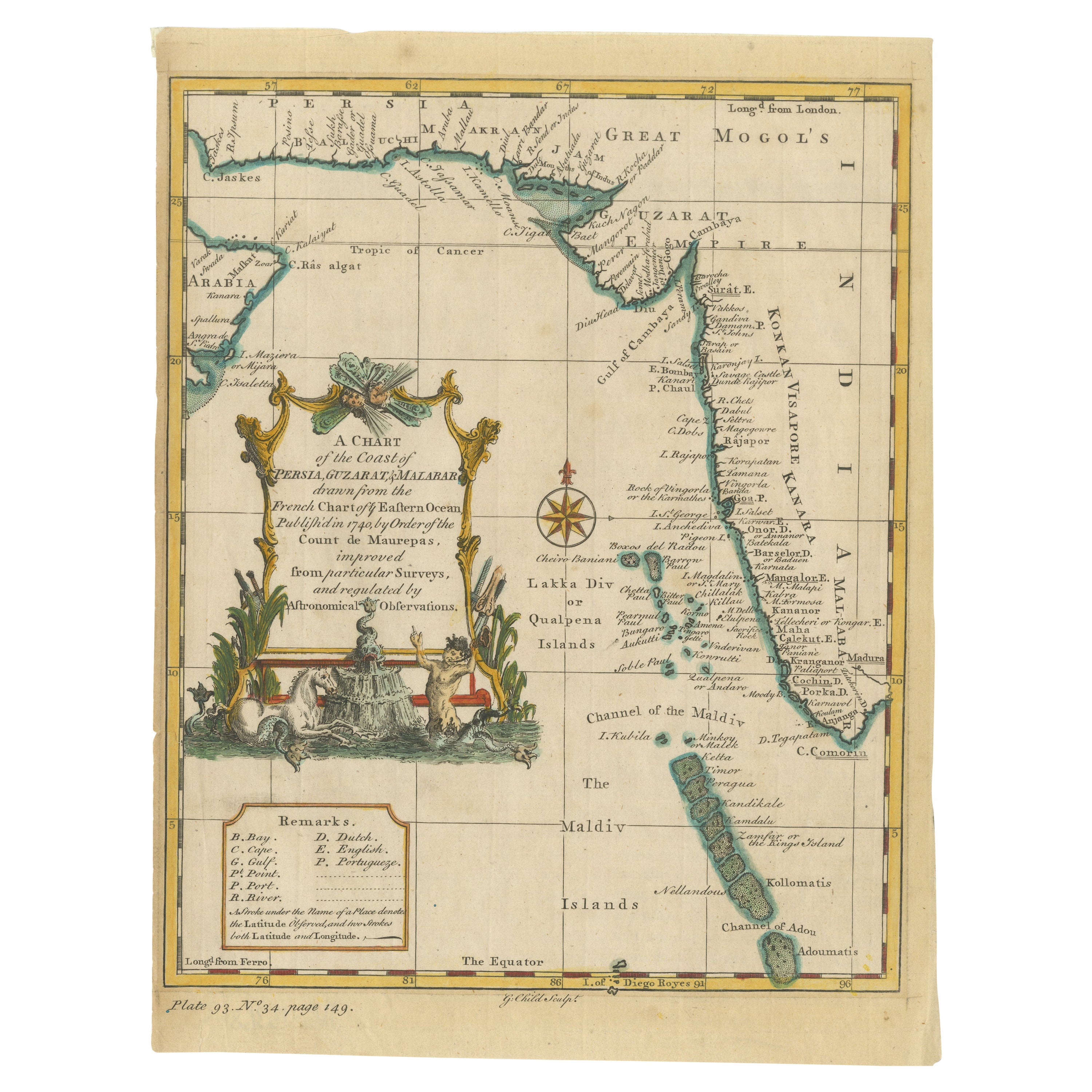
- Antique Map of the Region of the Arabian SeaLocated in Langweer, NLAntique map titled 'A Chart of the Coast of Persia, Guzarat & Malabar'. Old map centered on the Arabian Sea that shows some of the Persian Gulf and the Gulf of Oman, extending past P...Category
Antique Mid-18th Century Maps
MaterialsPaper
- Antique Map of the Region of Beauvais by Hondius, circa 1630Located in Langweer, NLAntique map titled 'Beauvaisis - Comitatus Belovacium'. Old map of the region of Beauvais, France. This map originates from a composite atlas and is signed by J. Hondius.Category
Antique Mid-17th Century Maps
MaterialsPaper


You May Also Like
- Original Antique Map of Belgium by Tallis, Circa 1850Located in St Annes, LancashireGreat map of Belgium Steel engraving Many lovely vignettes Published by London Printing & Publishing Co. ( Formerly Tallis ), C.1850 Origin...Category
Antique 1850s English Maps
MaterialsPaper
- 17th Century Hand Colored Map of the Liege Region in Belgium by VisscherBy Nicolaes Visscher IILocated in Alamo, CAAn original 17th century map entitled "Leodiensis Episcopatus in omnes Subjacentes Provincias distincté divisusVisscher, Leodiensis Episcopatus" by Nicolaes Visscher II, published in Amsterdam in 1688. The map is centered on Liege, Belgium, includes the area between Antwerp, Turnhout, Roermond, Cologne, Trier and Dinant. This attractive map is presented in a cream-colored mat measuring 30" wide x 27.5" high. There is a central fold, as issued. There is minimal spotting in the upper margin and a tiny spot in the right lower margin, which are under the mat. The map is otherwise in excellent condition. The Visscher family were one of the great cartographic families of the 17th century. Begun by Claes Jansz Visscher...Category
Antique Late 17th Century Dutch Maps
MaterialsPaper
- Civil War Panorama of the Seat of War by John Bachmann, Antique Print circa 1864Located in Colorado Springs, COPanorama of the seat of war. Bird's-eye View of Virginia, Maryland, Delaware and the District of Columbia. This third state of this fascinating bird's eye view of the northernmost p...Category
Antique 1860s American Maps
MaterialsPaper
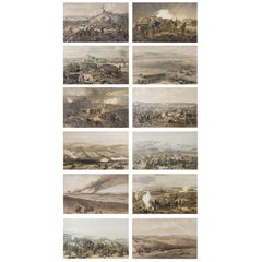
- Set of 12 Original Antique Prints of the Crimean Wars, circa 1860Located in St Annes, LancashireGreat set of 12 military prints. All related to the Crimean Wars. Lithographs in original colors after William Simpson. Published by P & D Colna...Category
Antique 1830s English Other Prints
MaterialsPaper
- The Normandy Region of France: A 17th C. Hand-colored Map by Sanson and JaillotBy Nicolas SansonLocated in Alamo, CAThis large hand-colored map entitled "Le Duché et Gouvernement de Normandie divisée en Haute et Basse Normandie en divers Pays; et par evêchez, avec le Gouvernement General du Havre ...Category
Antique 1690s French Maps
MaterialsPaper
- Original Antique Map of South America, circa 1830Located in St Annes, LancashireGreat map of South America Copper plate engraving Published by Butterworth, Livesey & Co., circa 1830 Unframed.Category
Antique Early 1800s English Other Maps
MaterialsPaper


Recently Viewed
View AllMore Ways To Browse
Mid Century Glass Ceiling Fixture
Dining Room Chairs Danish Wood
Belgium Antique Furniture Chair
Hans Agne Jakobsson Lighting
Black Painted Door
Vintage Mid Century Modern Furniture Canada
20 Century Vases
Brass Globe Light
Glass Floral Arrangements
Pair Of Midcentury Storage Cabinet
Vintage Red Dining Set
Vintage Miller Sign
French Walnut Furniture Louis Xv
Man On Chair
Used Foldable Chairs
Plinth Modern
Mid Century Glass Leaves
Small Cabinets And Tables