Items Similar to Detailed Antique Map of the Southern Part of European Russia and Ukraine, 1752

Want more images or videos?
Request additional images or videos from the seller
1 of 5
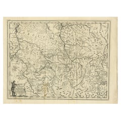
Detailed Antique Map of the Southern Part of European Russia and Ukraine, 1752
$718.32
$897.9020% Off
£538.43
£673.0320% Off
€608
€76020% Off
CA$986.85
CA$1,233.5720% Off
A$1,101.73
A$1,377.1620% Off
CHF 577.29
CHF 721.6120% Off
MX$13,486.25
MX$16,857.8120% Off
NOK 7,331.59
NOK 9,164.4820% Off
SEK 6,912.75
SEK 8,640.9420% Off
DKK 4,628.32
DKK 5,785.4020% Off
About the Item
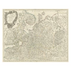
Antique map titled 'Partie meridionale de la Russie Européenne'.
Detailed map of the southern part of European Russia by Robert de Vaugondy. It covers from Moscow south to Georgia and from Poland east to the Volga River, including Crimea and Ukraine.
Artists and engravers: Gilles Robert de Vaugondy (1688-1766) was the head of a leading family of geographers in eighteenth century France. Gilles got his start when he jointly inherited the shop of Pierre-Moullart Sanson, grandson of the famous geographer Nicholas Sanson. The inheritance included the business, its stock of plates, and a roller press. In 1760 Gilles became geographer to King Louis XV. His son, Didier Robert de Vaugondy (ca. 1723-1786), was also a geographer and the two worked together. They were known for their exactitude and depth of research. In 1757, they produced the Atlas Universel, considered an authority for many years.
- Dimensions:Height: 19.69 in (50 cm)Width: 25.99 in (66 cm)Depth: 0 in (0.02 mm)
- Materials and Techniques:
- Period:1750-1759
- Date of Manufacture:1752
- Condition:Wear consistent with age and use. Condition: Good, general age-related toning. Minor wear, please study image carefully.
- Seller Location:Langweer, NL
- Reference Number:Seller: BG-12183-2 1stDibs: LU3054327228792
About the Seller
5.0
Recognized Seller
These prestigious sellers are industry leaders and represent the highest echelon for item quality and design.
Platinum Seller
Premium sellers with a 4.7+ rating and 24-hour response times
Established in 2009
1stDibs seller since 2017
2,513 sales on 1stDibs
Typical response time: <1 hour
- ShippingRetrieving quote...Shipping from: Langweer, Netherlands
- Return Policy
Authenticity Guarantee
In the unlikely event there’s an issue with an item’s authenticity, contact us within 1 year for a full refund. DetailsMoney-Back Guarantee
If your item is not as described, is damaged in transit, or does not arrive, contact us within 7 days for a full refund. Details24-Hour Cancellation
You have a 24-hour grace period in which to reconsider your purchase, with no questions asked.Vetted Professional Sellers
Our world-class sellers must adhere to strict standards for service and quality, maintaining the integrity of our listings.Price-Match Guarantee
If you find that a seller listed the same item for a lower price elsewhere, we’ll match it.Trusted Global Delivery
Our best-in-class carrier network provides specialized shipping options worldwide, including custom delivery.More From This Seller
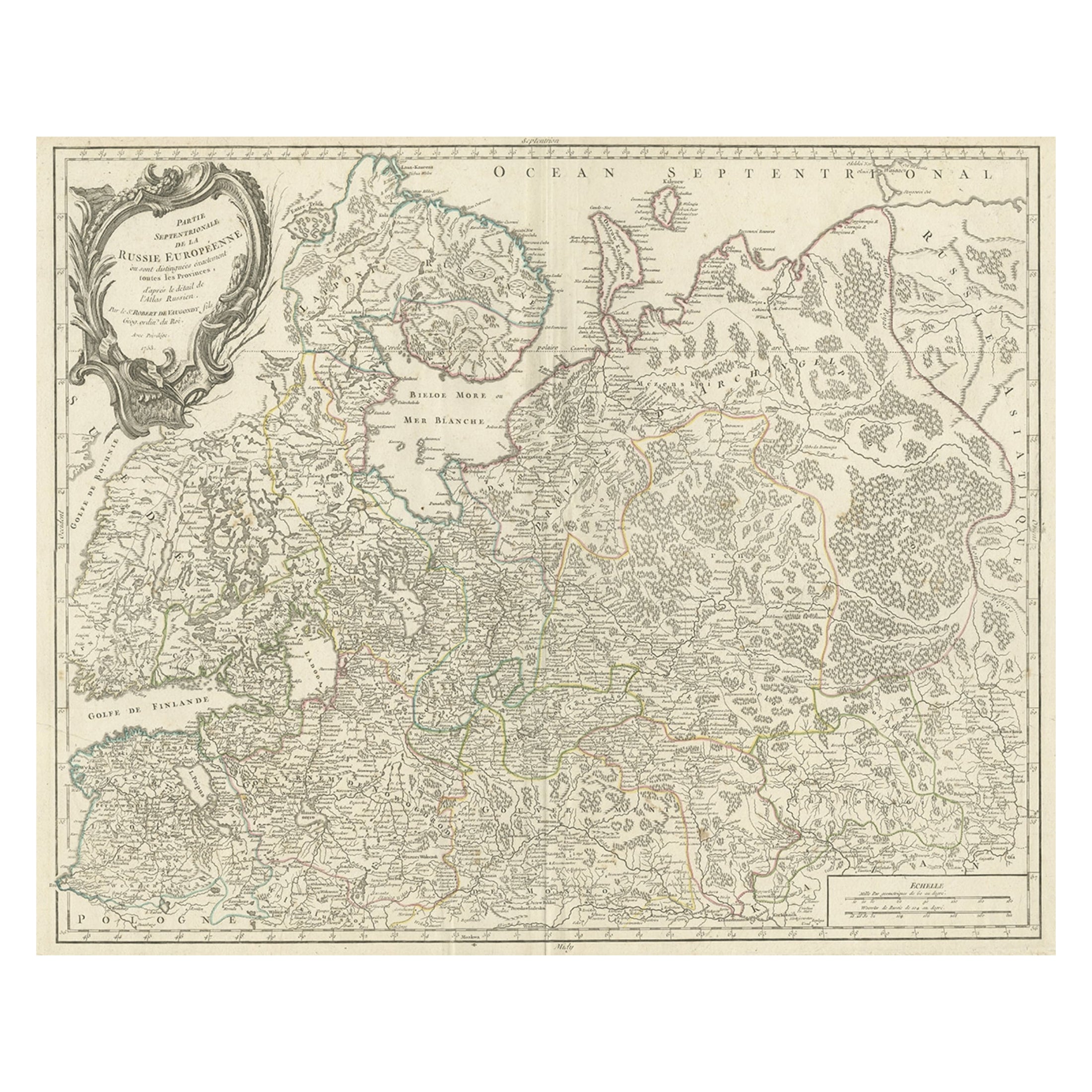
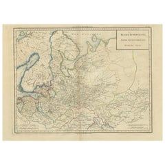
View AllOriginal Antique Map of the Northwestern Part of Russia in Europe, 1753
Located in Langweer, NL
Antique map titled 'Partie septentrionale de la Russie Européenne'.
Detailed map of the Northwestern part of Russia, from the Gulf of Finland and Poland, to the western part of Asian Russia.
Artists and Engravers: Gilles Robert de Vaugondy (1688-1766) was the head of a leading family of geographers in eighteenth century France. Gilles got his start when he jointly inherited the shop of Pierre-Moullart Sanson, grandson of the famous geographer Nicholas Sanson. The inheritance included the business, its stock of plates, and a roller press...
Category
Antique 1750s Maps
Materials
Paper
$557 Sale Price
20% Off
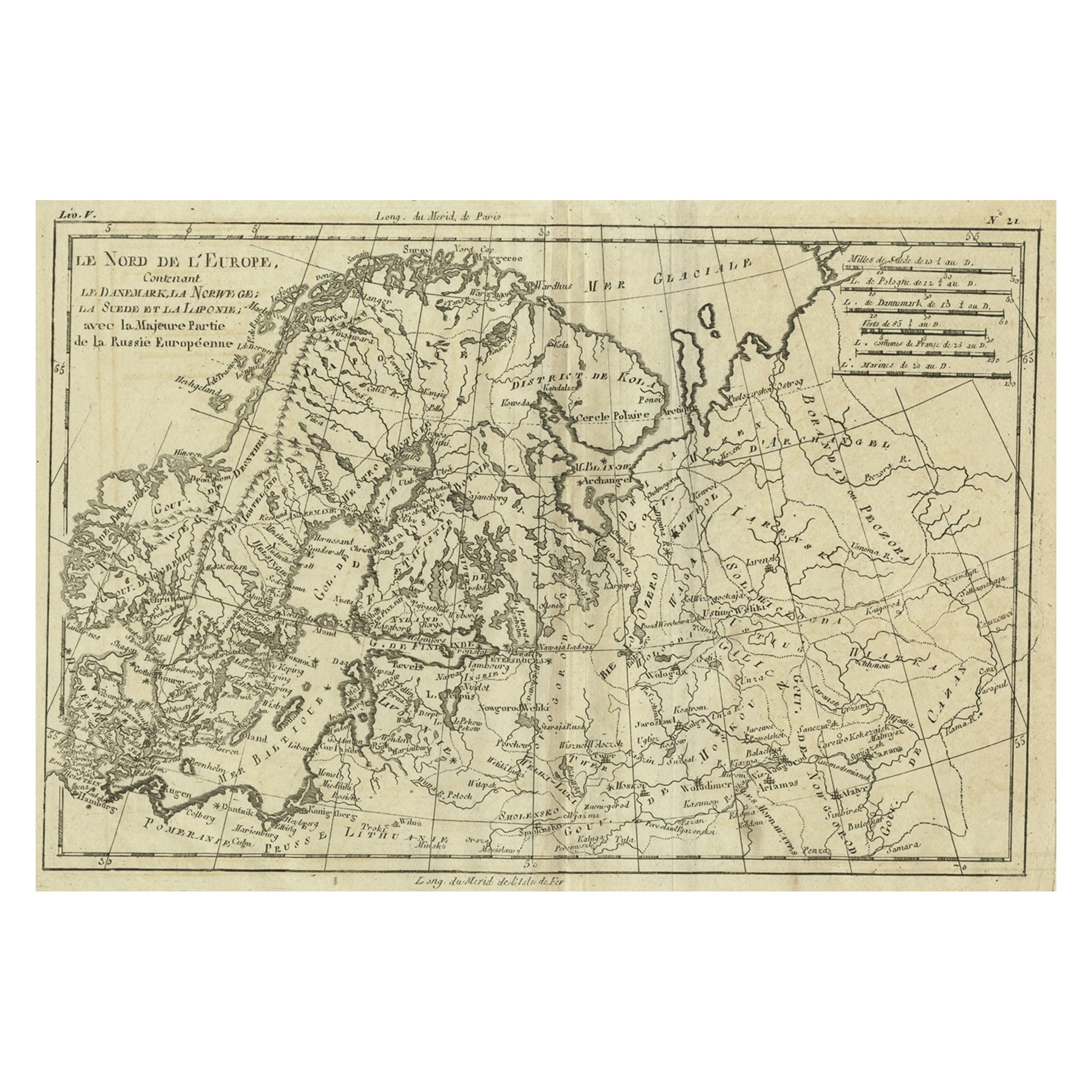
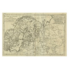
Antique Map of Northern Europe and European Russia, ca.1780
Located in Langweer, NL
Antique map titled 'Le Nord de L'Europe, Contenant Le Danemark, La Norwege; La Suede et La Laponie avec la Majeure Partie de al Russie Europeenne.'
Map of Northern Europe and Eur...
Category
Antique 1780s Maps
Materials
Paper
$179 Sale Price
20% Off
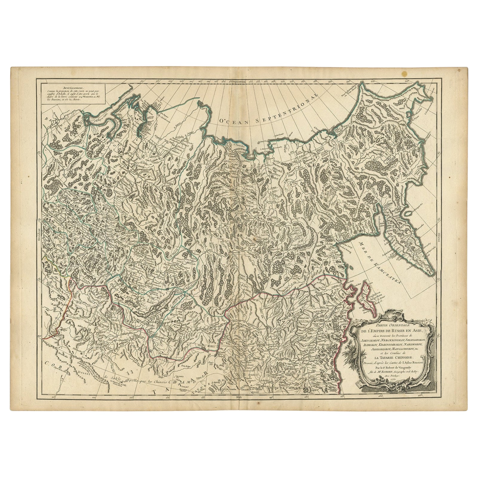
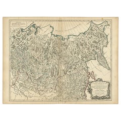
Detailed Original Antique Map of the Russian Empire in Asia, 1750
Located in Langweer, NL
Antique map titled 'Partie Orientale de l'Empire de Russie en Asie (..)'.
Detailed map of the Russian Empire in Asia.
Artists and Engravers: Gilles Robert de Vaugondy (1688-1766) was the head of a leading family of geographers in eighteenth century France. Gilles got his start when he jointly inherited the shop of Pierre-Moullart Sanson, grandson of the famous geographer Nicholas Sanson. The inheritance included the business, its stock of plates, and a roller press...
Category
Antique 1750s Maps
Materials
Paper
$557 Sale Price
20% Off
Antique Map of Russia in Europe by T. Kitchin, circa 1770
Located in Langweer, NL
Antique map titled 'Russia or Moscovy in Europe, drawn from the latest authorities (..)'. An interesting and attractive early 19th century map of Russia in Europe which was engraved ...
Category
Antique Late 18th Century Maps
Materials
Paper

$151 Sale Price
20% Off
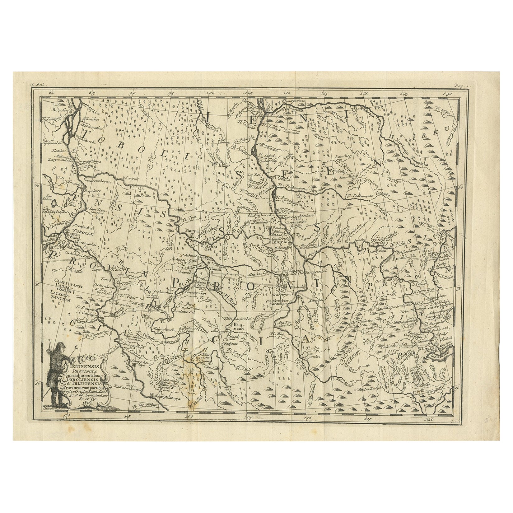
Antique Map of Part of Russia, c.1740
Located in Langweer, NL
Antique map titled 'Ienisensis Provinicia cum adjacentibus Toboliensis & Irkutensis'. Old map of part of Russia including the city of Tobolsk and others. Source unknown, to be determ...
Category
Antique 18th Century Maps
Materials
Paper
$129 Sale Price
20% Off
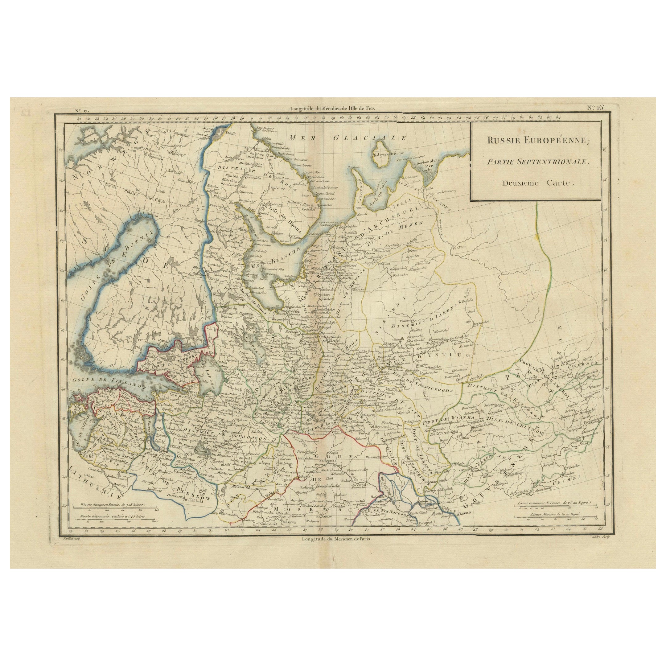
Map of Northern European Russia: Early 19th Century - 1802 Tardieu Atlas
Located in Langweer, NL
Title: Russie Européenne: Partie Septentrionale. Deuxieme Carte.
**Publication Details:**
- **Atlas Title:** Nouvel Atlas Universel de Géographie Ancienne et Moderne
- **Purpose:**...
Category
Antique Early 1800s Maps
Materials
Paper
$453 Sale Price
20% Off
You May Also Like
1849 Map of "Europaische Russland", 'Meyer Map of European Russia', Ric. R017
Located in Norton, MA
1849 Map of
"Europaische Russland"
( Meyer Map of European Russia)
Ric.r017
A lovely map of European Russia dating to 1849 by Joseph Meyer. It covers the European portions of...
Category
Antique 19th Century Unknown Maps
Materials
Paper

17th Century Nicolas Visscher Map of Southeastern Europe
Located in Hamilton, Ontario
A beautiful, highly detailed map of southeastern Europe by Nicolas Visscher. Includes regions of Northern Italy (showing the cities Bologna, Padua, and Venice), Bohemia, Austria (sho...
Category
Antique 17th Century Dutch Maps
Materials
Paper

$1,350 Sale Price
38% Off
Original Antique Map of Hungary, Arrowsmith, 1820
Located in St Annes, Lancashire
Great map of Hungary
Drawn under the direction of Arrowsmith.
Copper-plate engraving.
Published by Longman, Hurst, Rees, Orme and Brown, 1820
Unframed.
Category
Antique 1820s English Maps
Materials
Paper

1814 Map of "Russian Empire" Ric.r032
Located in Norton, MA
1814 Map of
"Russian Empire"
Ric.r032
Russian Empire. Description: This is an 1814 John Thomson map of the Russian Empire. The map depicts the region from the Baltic Sea, Prussia, and Sweden to the Aleutian Islands and from the Arctic Ocean to the Yellow River. Highly detailed, myriad cities, towns, and villages are labeled throughout, including St. Petersburg, Moscow, Minsk, Kiev, and Kharkov. Rivers and mountain ranges are also identified, as are islands and numerous locations along the coastlines. It is important to note that the long-disputed sea between Korea and Japan is identified as the 'Sea of Japan.
Historical Context:
In 1815, Tsarist Russia emerged from the Napoleonic Wars economically insolvent and politically fearful of the Revolutionary fervor that had just swept through Europe. In order to shore up Russia's economic position, the Tsars began an aggressive series of expansions into the Caucuses and Central Asia that would vastly increase the landmass of the Russian Empire.
Publication History
Thomson maps are known for their stunning color, awe inspiring size, and magnificent detail. Thomson's work, including this map, represents some of the finest cartographic art...
Category
Antique 19th Century Unknown Maps
Materials
Paper

1853 Map of "Russia in Europe Including Poland" Ric.r016
Located in Norton, MA
Description
Russia in Europe incl. Poland by J Wyld c.1853
Hand coloured steel engraving
Dimension: Paper: 25 cm W x 33 cm H ; Sight: 22 cm W x 28 cm H
Condition: Good ...
Category
Antique 19th Century Unknown Maps
Materials
Paper

1790 Thomas Stackhouse Map, Entitled "Russia in Europe, " , Ric.a004
Located in Norton, MA
1790 Thomas Stackhouse map, entitled
"Russia in Europe"
Ric.a004
Stackhouse, Thomas
Russia in Europe [map]
London: T. Stackhouse, 1783. Map. Matted hand-colored copper engraving. Image size: 14.5 x 15.25 inches. Mat size: 22.75 x 23.75 inches. A beautiful example of this map of Eastern Europe...
Category
Antique 17th Century Unknown Maps
Materials
Paper

More Ways To Browse
Antique Paper Roller
Ukraine Antique Map
Map Ukraine
Antique Maps Of Sicily
Antique Celestial Maps
Antique Compass Maritime Compasses
Bengal Map
J C Walker Map
Map Of Ancient Greece
Ptolemy Map
Antique Marine Compass
Map Of Jerusalem
1820 World Map
Cyprus Antique Maps
Antique Ecuador
Antique Map Of Thailand
Antique Mississippi Map
Antique Ohio Maps