Items Similar to Exquisite 1580 Ortelius Map of the Narbonne Coastal Region, France
Want more images or videos?
Request additional images or videos from the seller
1 of 6
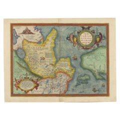
Exquisite 1580 Ortelius Map of the Narbonne Coastal Region, France
$566.07
$707.5820% Off
£423.72
£529.6420% Off
€480
€60020% Off
CA$779.07
CA$973.8420% Off
A$868.36
A$1,085.4420% Off
CHF 455.60
CHF 569.5020% Off
MX$10,604.04
MX$13,255.0420% Off
NOK 5,768.84
NOK 7,211.0520% Off
SEK 5,452.43
SEK 6,815.5420% Off
DKK 3,654.10
DKK 4,567.6220% Off
About the Item
"Exquisite 1580 Ortelius Map of the Narbonne Coastal Region, France"
Description of the Map:
This map is an intricate copper etching from Abraham Ortelius's esteemed "Theatrum Orbis Terrarum," produced around 1580.
It features the Mediterranean coastline of the ancient Gallia Narbonensis, extending from Marseille through Narbonne up to the French-Spanish border.
The map is designed with a westward orientation, highlighting detailed depictions of geographical and urban elements along this historical region. The artwork includes a visually appealing title cartouche, a navigational compass, and a mileage key, all set against the Mediterranean backdrop. Decorative borders enhance the map's aesthetic appeal, making it a striking piece of historical art.
Condition of the Map:
The map exhibits some age toning and light spotting along the margins, which are minor signs of its age and historical use. The right margin is described as narrow, suggesting some wear or possible trimming in past handling. Despite these signs of age, the map remains in good condition, retaining its clarity and vibrant features.
This map would be highly sought after by collectors due to its origin from Ortelius's groundbreaking atlas and its detailed representation of an important historical region of France. The decorative elements and the map's overall charm contribute to its desirability among those interested in maritime and regional cartography from the Renaissance period.
- Dimensions:Height: 15.56 in (39.5 cm)Width: 11.23 in (28.5 cm)Depth: 0 in (0.02 mm)
- Materials and Techniques:Paper,Engraved
- Period:
- Date of Manufacture:circa 1580
- Condition:Condition: Good, given age. General age-related toning and occasional minor defects from handling. Short on the right margin. Please study scan carefully.
- Seller Location:Langweer, NL
- Reference Number:Seller: BG-13644-41stDibs: LU3054341305272
About the Seller
5.0
Recognized Seller
These prestigious sellers are industry leaders and represent the highest echelon for item quality and design.
Platinum Seller
Premium sellers with a 4.7+ rating and 24-hour response times
Established in 2009
1stDibs seller since 2017
2,513 sales on 1stDibs
Typical response time: <1 hour
- ShippingRetrieving quote...Shipping from: Langweer, Netherlands
- Return Policy
Authenticity Guarantee
In the unlikely event there’s an issue with an item’s authenticity, contact us within 1 year for a full refund. DetailsMoney-Back Guarantee
If your item is not as described, is damaged in transit, or does not arrive, contact us within 7 days for a full refund. Details24-Hour Cancellation
You have a 24-hour grace period in which to reconsider your purchase, with no questions asked.Vetted Professional Sellers
Our world-class sellers must adhere to strict standards for service and quality, maintaining the integrity of our listings.Price-Match Guarantee
If you find that a seller listed the same item for a lower price elsewhere, we’ll match it.Trusted Global Delivery
Our best-in-class carrier network provides specialized shipping options worldwide, including custom delivery.More From This Seller
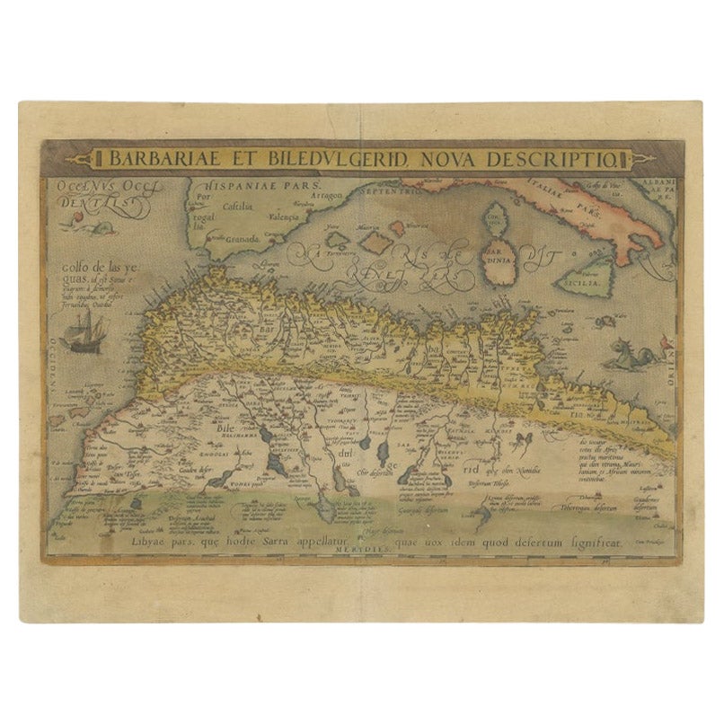
View AllAntique Map of North Africa by Ortelius, c.1580
Located in Langweer, NL
Antique map titled 'Barbariae et Biledulgerid Nova Descriptio'. Original antique map of North Africa. The map covers the regions of Barbaria and Biledulgerid, essentially the territo...
Category
Antique 16th Century Maps
Materials
Paper
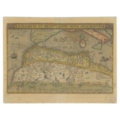
$338 Sale Price
20% Off
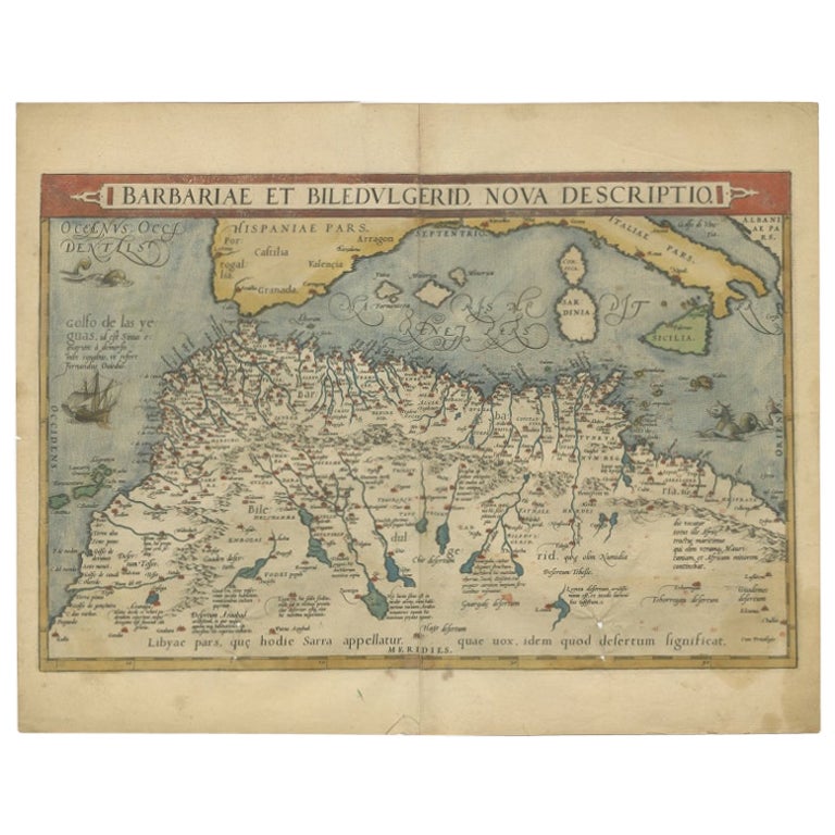
Antique Map of North Africa by Ortelius, c.1600
Located in Langweer, NL
Antique map titled 'Barbariae et Biledulgerid nova descriptio'.
Old map of coastal North Africa and the Mediterranean. The map extends from Morocco and the Sahara to Libya and sh...
Category
Antique 17th Century Maps
Materials
Paper
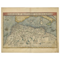
$353 Sale Price
20% Off
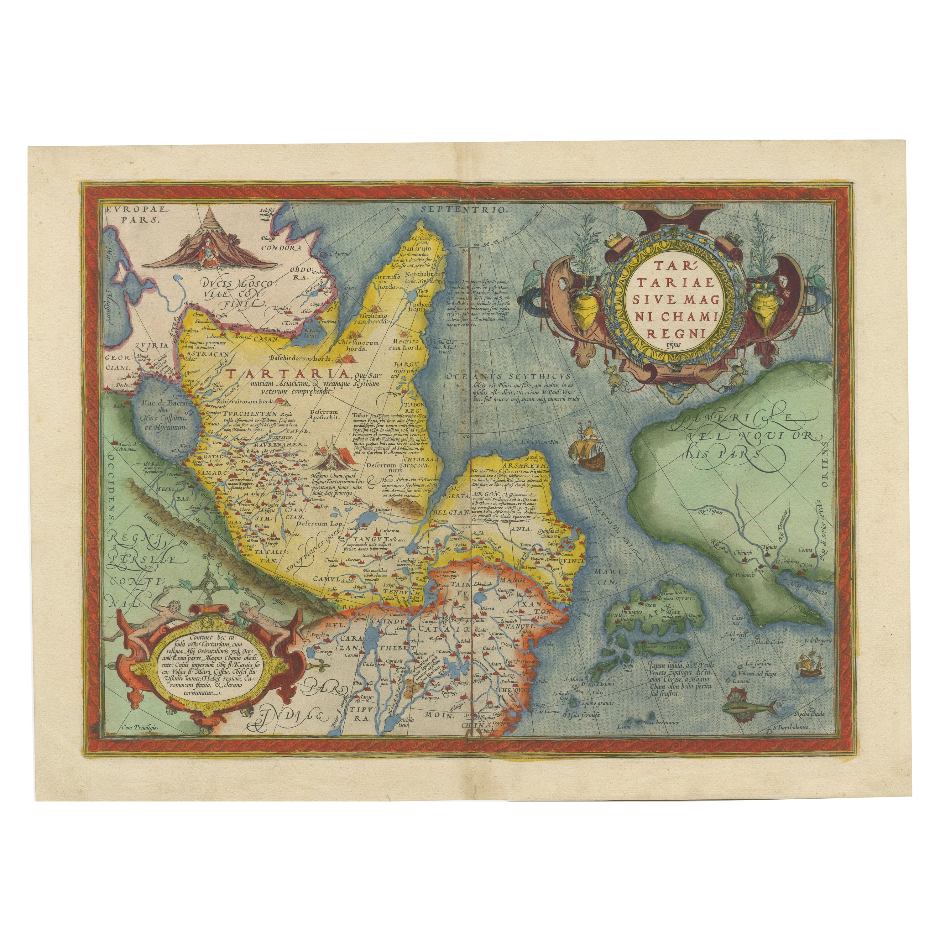
1573 Ortelius Map: First to Name California, Spanning Tartary to North America
Located in Langweer, NL
"1573 Abraham Ortelius Map of Tartary, Japan, and Western North America"
Description of the Map:
This is an outstanding example of Abraham Ortelius' map titled "Tartariae Sive Magn...
Category
Antique 16th Century Maps
Materials
Paper
$2,264 Sale Price
20% Off
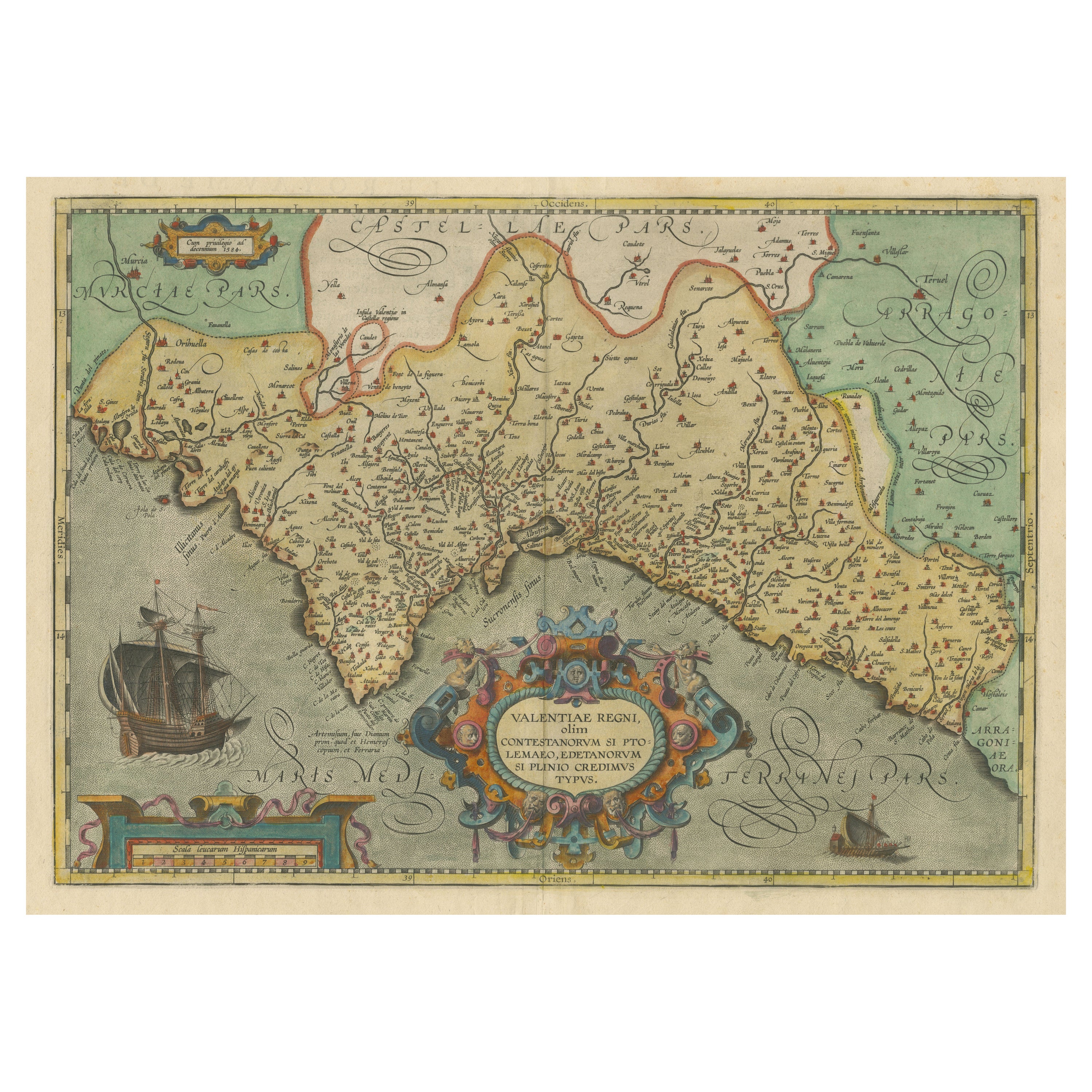
Decorative Original Antique Map of Valencia in Southern Spain, circa 1601
Located in Langweer, NL
This is an original antique map titled 'Valentiae Regni olim Contestanorum Si Ptolemaeo, Edentanorum Si Plinio Credimus Typus'. This is a historical map of the Kingdom of Valencia in...
Category
Antique Early 17th Century Maps
Materials
Paper

$1,320 Sale Price
20% Off
Free Shipping
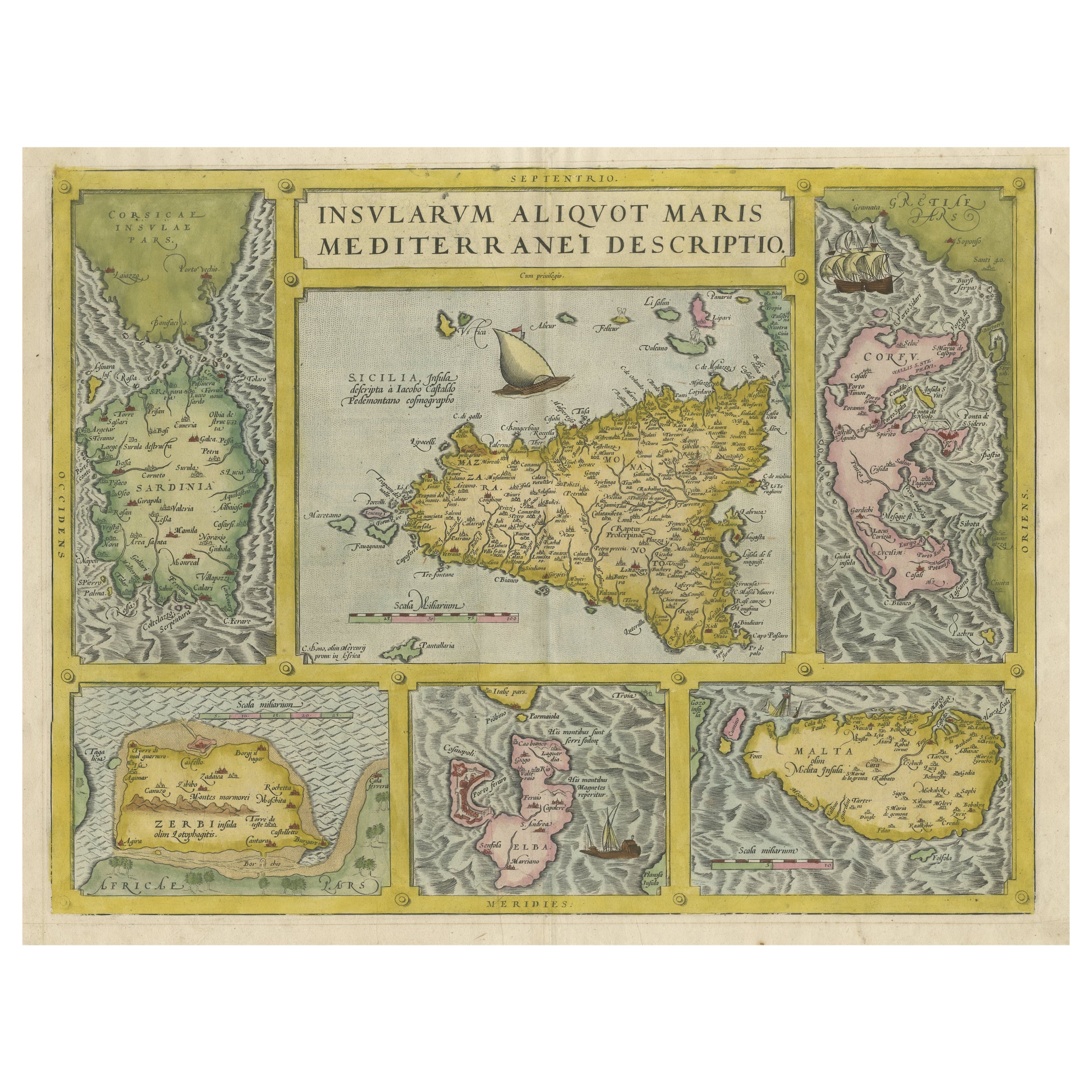
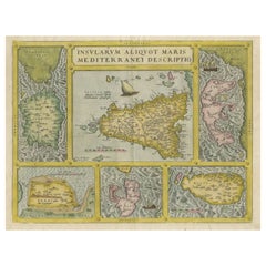
Coloured Antique Map of Sicily, Sardinia, Corfu, Elba, Malta and Zerbi (Jerba)
By Abraham Ortelius
Located in Langweer, NL
Antique map titled 'Insularum Aliquot Maris Mediterranei Descriptio'. A very attractive example of Ortelius' map combining, on one page, maps of the islands of Sicily, Sardinia, Corfu, Elba, Malta and Zerbi (Jerba, off the coast of Tunisia.) The maps detail fortifications on the islands and other major features. (Jerba, for instance, is shown connected to the mainland by a causeway.) The waters are attractively engraved and are sailed by ships. A shipwreck, north of Malta, indicates the point at which St. Paul is thought to have shipwrecked. Volcanoes are indicated in the Sicily map...
Category
Antique 16th Century Maps
Materials
Paper
$1,556 Sale Price
40% Off
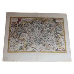
Antique Map of the Picardy Region of France by Ortelius, 'circa 1590'
Located in Langweer, NL
Antique map titled 'Picardiae Belgicae regionis descriptio'. Original antique map of the Picardy region, France. Published by A. Ortelius, circa 1590.
Category
Antique 16th Century Maps
Materials
Paper

$566 Sale Price
20% Off
You May Also Like
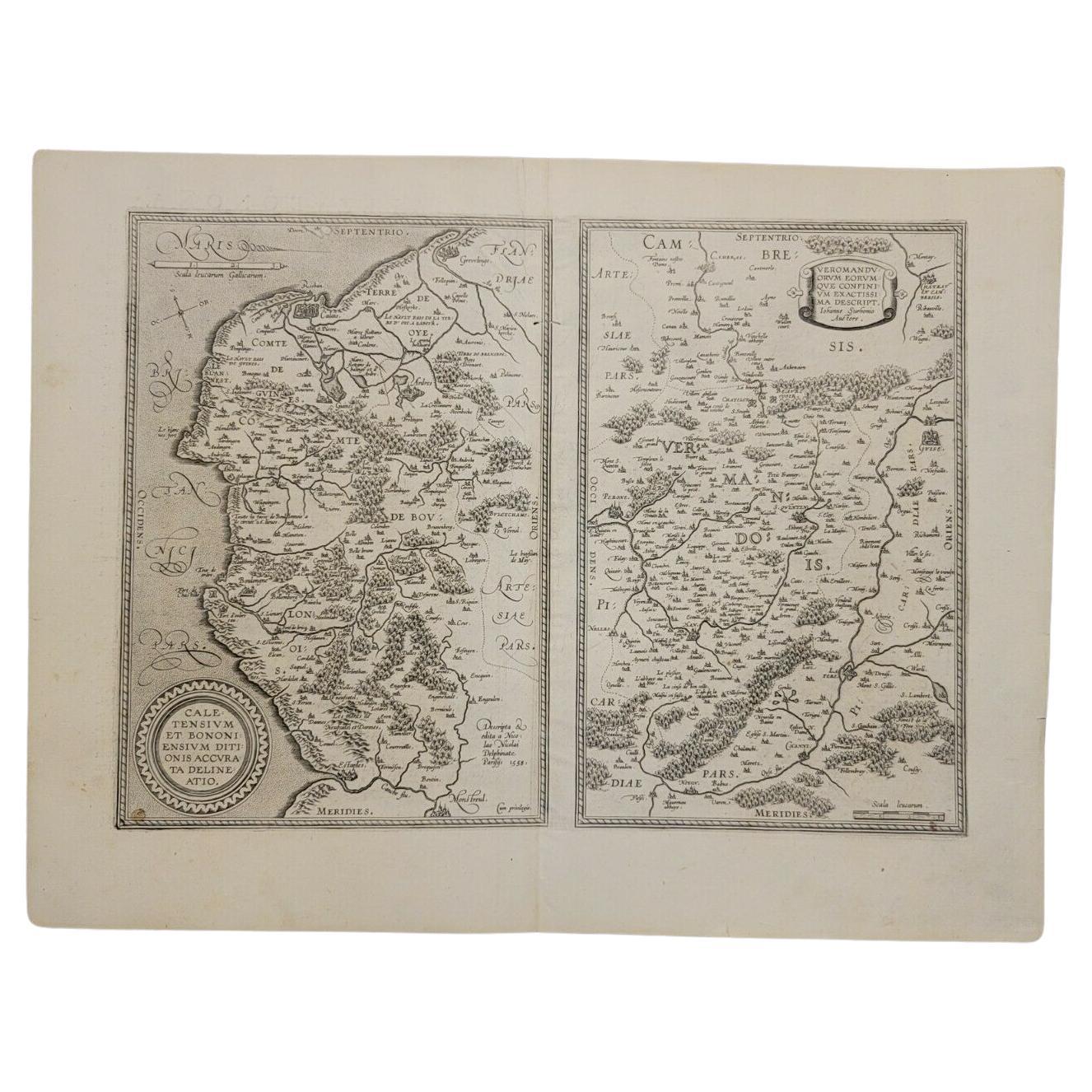
1590 Ortelius Map of Calais and Vermandois, France and Vicinity Ric.a014
Located in Norton, MA
1590 Ortelius map of
Calais and Vermandois, France and Vicinity
Ric.a014
Two rare regional Abraham Ortelius maps on a single folio sheet. Left map, entitled Caletensium, depic...
Category
Antique 16th Century Dutch Maps
Materials
Paper

1592 Abraham Ortelius Map "Lorraine: Lotharingiae Nova Descripti, Ric.A005
Located in Norton, MA
1592 Abraham Ortelius map entitled
"Lorraine: Lotharingiae Nova Descripti
Ric.a005
Description: Ortelius is best known for producing the atlas from which this map comes from, "...
Category
Antique 16th Century Dutch Maps
Materials
Paper

1597 Abraham Ortelius Map Burgundy, France Entitled "Bvrgvndiae dvcatvs Ric.a010
Located in Norton, MA
1597 Abraham Ortelius map of Burgundy, France entitled
"Bvrgvndiae dvcatvs
Ric.a010
Description: Ortelius is best known for producing the atla...
Category
Antique 16th Century Dutch Maps
Materials
Paper

"Nova Barbariae Descriptio", a 17th Century Hand-Colored Map of North Africa
By Johannes Janssonius
Located in Alamo, CA
This original attractive 17th century hand-colored map of North Africa entitled "Nova Barbariae Descriptio" by Johannes Janssonius was published in Paris in 1635. It includes the Med...
Category
Antique Mid-17th Century Dutch Maps
Materials
Paper

1590 Mercator Map Entitled "France Picardie Champaigne, Ric.0001
Located in Norton, MA
Description: Published in Amsterdam by Mercator/Hondius ca. 1590.
Ric.0001
Artists and Engravers: Map : 'France Picardie Champaigne cum regionibus adiacentibus'. (Map of the french provinces of Picardie and Champagne.) Copper engraved map of the french provinces of Picardie and Champagne, showing the cities of Caen, Paris, Melun, Auxerre, Verdun, etc. Copperplate engraving on verge type hand laid paper with watermark. Description: Published in Amsterdam by Mercator/Hondius ca. 1600.Artists and Engravers: Mercator was born in Rupelmonde in Flanders and studied in Louvain under Gemma Frisius, Dutch writer, astronomer and mathematician. The excellence of his work brought him the patronage of Charles V, but in spite of his favor with the Emperor he was caught up in the persecution of Lutheran protestants and charged with heresy, fortunately without serious consequences. No doubt the fear of further persecution influenced his move in 1552 to Duisburg, where he continued the production of maps, globes and instruments. Mercator's sons and grandsons, were all cartographers and made their contributions in various ways to his atlas. Rumold, in particular, was responsible for the complete edition in 1595. The map plates...
Category
Antique 16th Century Dutch Maps
Materials
Paper

1612 Abraham Ortelius, Entitled "Lorraine, Lotharingiae, Nova Desciptio, " Ric008
Located in Norton, MA
1612 Abraham Ortelius, entitled
"Lorraine, Lotharingiae, Nova Desciptio,"
Hand Colored
Description:
Artists and Engravers: Ortelius is the best known for producing the atla...
Category
Antique 17th Century Dutch Maps
Materials
Paper
More Ways To Browse
Spanish Copper Antique
Antique Curiosities Artwork
Antique Gallia
Tables With Inlaid Wood
World War Table
Antonio Jacobsen
Ariston Chairs
Coffee Tables Europe
Marble Top Dining Tables
Nordiska Argentina
Pink And Black Rug
Black Wooden Chair
Orrefors Embassy
Black Ebonized
Elios Chair
Panache Designs
Plata Lappas
Red Retro Dining Set