Items Similar to Large Decorative Colonial-Era Map of South India – Peninsula of India, 1800
Want more images or videos?
Request additional images or videos from the seller
1 of 13
Large Decorative Colonial-Era Map of South India – Peninsula of India, 1800
$2,851.80
£2,119.98
€2,400
CA$3,922.79
A$4,370.57
CHF 2,305.05
MX$52,986.11
NOK 29,323.61
SEK 27,316.80
DKK 18,284.30
About the Item
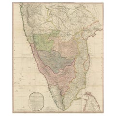
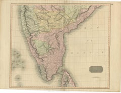
Antique Map of South India – “A Map of the Peninsula of India,” London 1800
This large and detailed antique map titled *A Map of the Peninsula of India* was published in London in 1800 by James Rennell, one of the most respected British geographers and surveyors of the 18th century. The map focuses on the southern part of the Indian subcontinent, depicting the entire peninsula from Bombay (Mumbai) in the west to the Bay of Bengal in the east, and extending southward to include the island of Ceylon (now Sri Lanka).
Originally created for the East India Company, this map was designed to provide strategic geographic information for British colonial administration and trade in the region. It delineates the political boundaries of the time, outlining regions controlled by various local powers, such as the Marathas, the Nizam of Hyderabad, the Carnatic, Mysore, Malabar, and the British settlements along the coasts.
Rennell's cartography is notable for its precision, with detailed notations of rivers, roads, mountain ranges, forts, and towns. The map includes a decorative cartouche at the bottom left bearing the full title, publication date, and the name of the mapmaker, along with a list of the principal geographical sources consulted for its construction.
What makes this map especially significant is that it was compiled at a time of intense conflict and transformation in the Indian subcontinent, during the period of the Anglo-Mysore Wars and growing British expansion into the south. As such, it offers invaluable insight into both the geography and political landscape of India at the end of the 18th century.
Collectors and historians prize this map not only for its historical accuracy but also for its visual appeal—delicate hand-colored borders demarcate the different regions, and the engraving is fine and detailed throughout.
Condition: Very good condition for its age. Original hand-coloring of borders. Some folds are visible as issued (folding map), with minor browning along fold lines and a few small paper splits at intersections. No restoration. Printed on strong laid paper.
Framing tips: A classic gold or teak frame with a light ivory mat would complement both the period style and subtle coloring of the map. Due to its size, consider float-mounting in a large-format frame with UV-protective glass.
Technique: Engraving with original hand coloring
Maker: James Rennell, London, 1792
- Dimensions:Height: 39.57 in (100.5 cm)Width: 33.08 in (84 cm)Depth: 0.01 in (0.2 mm)
- Materials and Techniques:
- Place of Origin:
- Period:
- Date of Manufacture:1800
- Condition:Condition: Very good condition for its age. Original hand-coloring of borders. Some folds are visible as issued (folding map), with minor browning along fold lines and a few small paper splits at intersections. No restoration. Strong laid paper.
- Seller Location:Langweer, NL
- Reference Number:Seller: BG-136201stDibs: LU3054346188562
About the Seller
5.0
Recognized Seller
These prestigious sellers are industry leaders and represent the highest echelon for item quality and design.
Platinum Seller
Premium sellers with a 4.7+ rating and 24-hour response times
Established in 2009
1stDibs seller since 2017
2,567 sales on 1stDibs
Typical response time: <1 hour
- ShippingRetrieving quote...Shipping from: Langweer, Netherlands
- Return Policy
Authenticity Guarantee
In the unlikely event there’s an issue with an item’s authenticity, contact us within 1 year for a full refund. DetailsMoney-Back Guarantee
If your item is not as described, is damaged in transit, or does not arrive, contact us within 7 days for a full refund. Details24-Hour Cancellation
You have a 24-hour grace period in which to reconsider your purchase, with no questions asked.Vetted Professional Sellers
Our world-class sellers must adhere to strict standards for service and quality, maintaining the integrity of our listings.Price-Match Guarantee
If you find that a seller listed the same item for a lower price elsewhere, we’ll match it.Trusted Global Delivery
Our best-in-class carrier network provides specialized shipping options worldwide, including custom delivery.More From This Seller
View AllOriginal Antique Map of the Peninsula of India with Part of Ceylon by Wyld, 1844
Located in Langweer, NL
This extensive map of India, spanning two sheets, draws from Reynell’s original map and incorporates data provided by Sir Archibald Campbell, as well as surveys conducted by Colonel ...
Category
Antique Mid-18th Century Maps
Materials
Paper
$1,140 Sale Price
20% Off
Free Shipping
Antique Map of Southern India and Ceylon by Thomson, 1816
Located in Langweer, NL
"Antique map titled 'Southern Hindostan'. A map of Southern India and the North of Ceylon. From Thomson's 'New General Atlas', 1816. Artists and Engravers: Engraved by Neele.
Arti...
Category
Antique 19th Century Maps
Materials
Paper
$166 Sale Price
20% Off
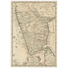
1816 Large Southern Hindostan Map by J. Thomson – New General Atlas
Located in Langweer, NL
Title: 1816 Southern Hindostan Map by J. Thomson – New General Atlas
This map, titled "Southern Hindostan," was published in 1816 as part of J. Thomson’s *New General Atlas*. The ma...
Category
Antique 1810s Maps
Materials
Paper
$503 Sale Price
20% Off
Map of Choromandel & Malabar, Incl Kerala, Tamil Nadu & Part of Sri Lanka, 1726
Located in Langweer, NL
Antique map titled 'Nieuwe kaart van Choromandel ende Malabar.'
Original antique map of Southern India documenting the VOC's areas of influence. Included is Kerala, Tamil Nadu...
Category
Antique 1720s Maps
Materials
Paper
$815 Sale Price
30% Off
Free Shipping
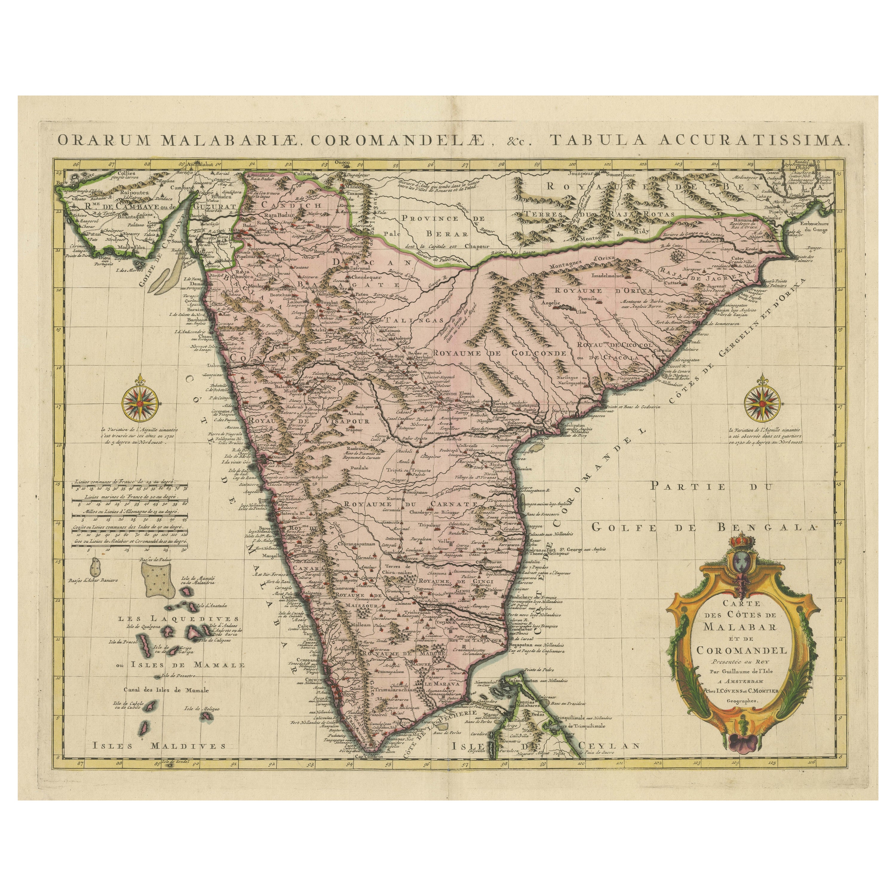
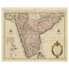
Original Hand-colored Antique Map of the Southern Part of India
Located in Langweer, NL
Antique map titled 'Orarum Malabariae, Coromandelae &c Tabula Accuratissima - Carte des Cotes de Malabar et de Coromandel'. Beautiful map of the southern part of India. It focuses on trade routes within India, as well as the Coromandel and Malabar Coasts...
Category
Antique Early 18th Century Maps
Materials
Paper
$865 Sale Price
20% Off
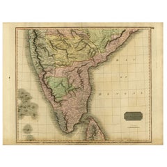
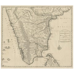
Original Detailed Antique Map of Southern India and Most of Ceylon, 1744
Located in Langweer, NL
Antique map titled 'A Map of India on the west Side of the Ganges, comprehending the coasts of Malabar, Coromandel and the Island Ceylon'.
Map of Southern India and most of Ceylo...
Category
Antique 1740s Maps
Materials
Paper
$418 Sale Price
20% Off
You May Also Like
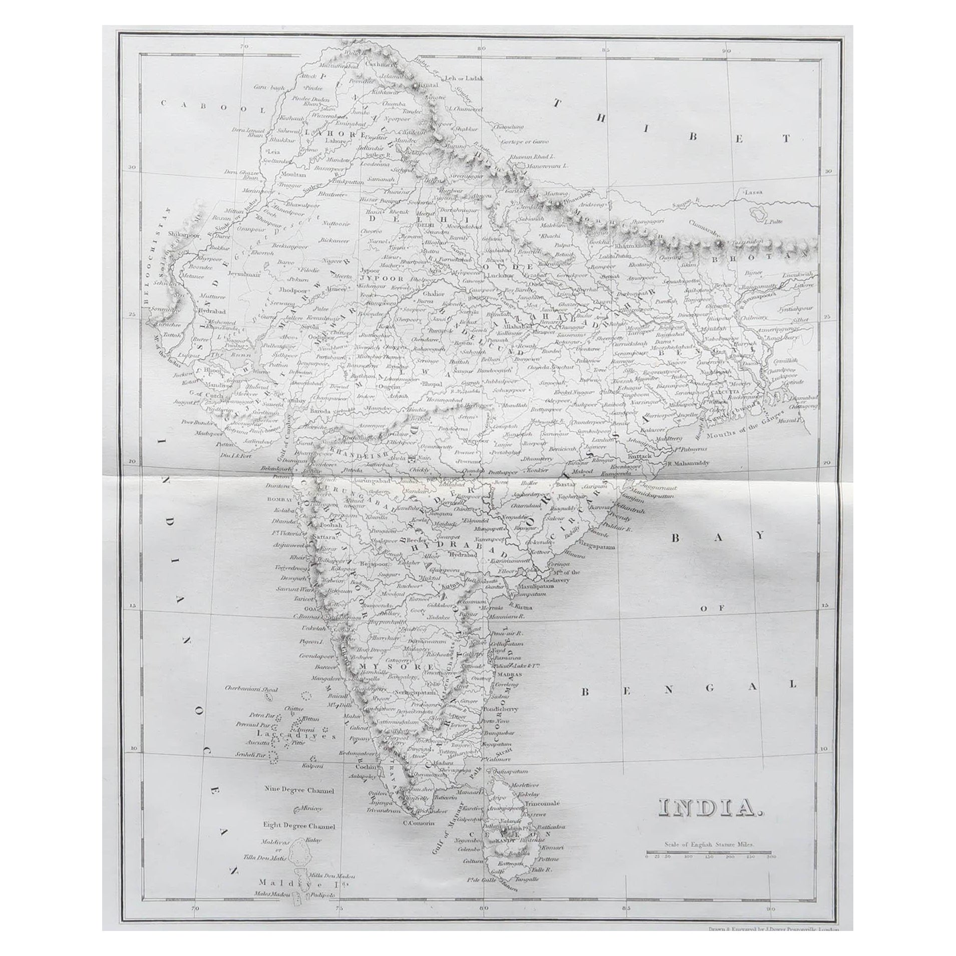
Original Antique Map of India by Dower, circa 1835
Located in St Annes, Lancashire
Nice map of India
Drawn and engraved by J.Dower
Published by Orr & Smith. C.1835
Unframed.
Free shipping
Category
Antique 1830s English Maps
Materials
Paper

Map Of India - Original Lithograph - 19th Century
Located in Roma, IT
Map of India is an original lithograph artwork realized by an Anonymous engraver of the 19th Century.
Printed in the series of "France Pittoresque".
Titled "France Pittoresque".
...
Category
19th Century Modern Figurative Prints
Materials
Lithograph

India (Southern Sheet), English antique map by Alexander Keith Johnston, 1901
Located in Melbourne, Victoria
'India (Southern Sheet)', antique lithographic map by Keith Johnston.
Inset maps of 'Bombay Island & Town', 'Madras & Environs', and 'South-Eastern Provinces of India'.
Central vertical fold as issued.
495mm by 625mm (sheet)
Alexander Keith...
Category
Early 20th Century Victorian More Prints
Materials
Lithograph

Large Original Vintage Map of India, circa 1920
Located in St Annes, Lancashire
Great map of India
Original color.
Good condition / repair to some minor damage just above Sri Lanka. Shown in the last image.
Published by Alexander Gross
Unframed.
Category
Vintage 1920s English Maps
Materials
Paper

Antique French Map of Asia Including China Indoneseia India, 1783
Located in Amsterdam, Noord Holland
Very nice map of Asia. 1783 Dedie au Roy.
Additional information:
Country of Manufacturing: Europe
Period: 18th century Qing (1661 - 1912)
Condition: Overall Condition B (Good Used)...
Category
Antique 18th Century European Maps
Materials
Paper

$648 Sale Price
20% Off
Antique 1803 Italian Map of Asia Including China Indoneseia India
Located in Amsterdam, Noord Holland
Antique 1803 Italian Map of Asia Including China Indoneseia India
Very nice map of Asia. 1803.
Additional information:
Type: Map
Country of Manufacturing: Europe
Period: 19th centu...
Category
Antique 19th Century European Maps
Materials
Paper

$584 Sale Price
20% Off