Items Similar to Levant in Antiquity: Lands of Phoenicia, Judea, and Neighboring Kingdoms, 1880

Want more images or videos?
Request additional images or videos from the seller
1 of 11
Levant in Antiquity: Lands of Phoenicia, Judea, and Neighboring Kingdoms, 1880
$349.71
$437.1420% Off
£262.13
£327.6620% Off
€296
€37020% Off
CA$480.44
CA$600.5520% Off
A$536.37
A$670.4620% Off
CHF 281.05
CHF 351.3120% Off
MX$6,565.68
MX$8,207.0920% Off
NOK 3,569.32
NOK 4,461.6620% Off
SEK 3,365.42
SEK 4,206.7720% Off
DKK 2,253.26
DKK 2,816.5720% Off
About the Item
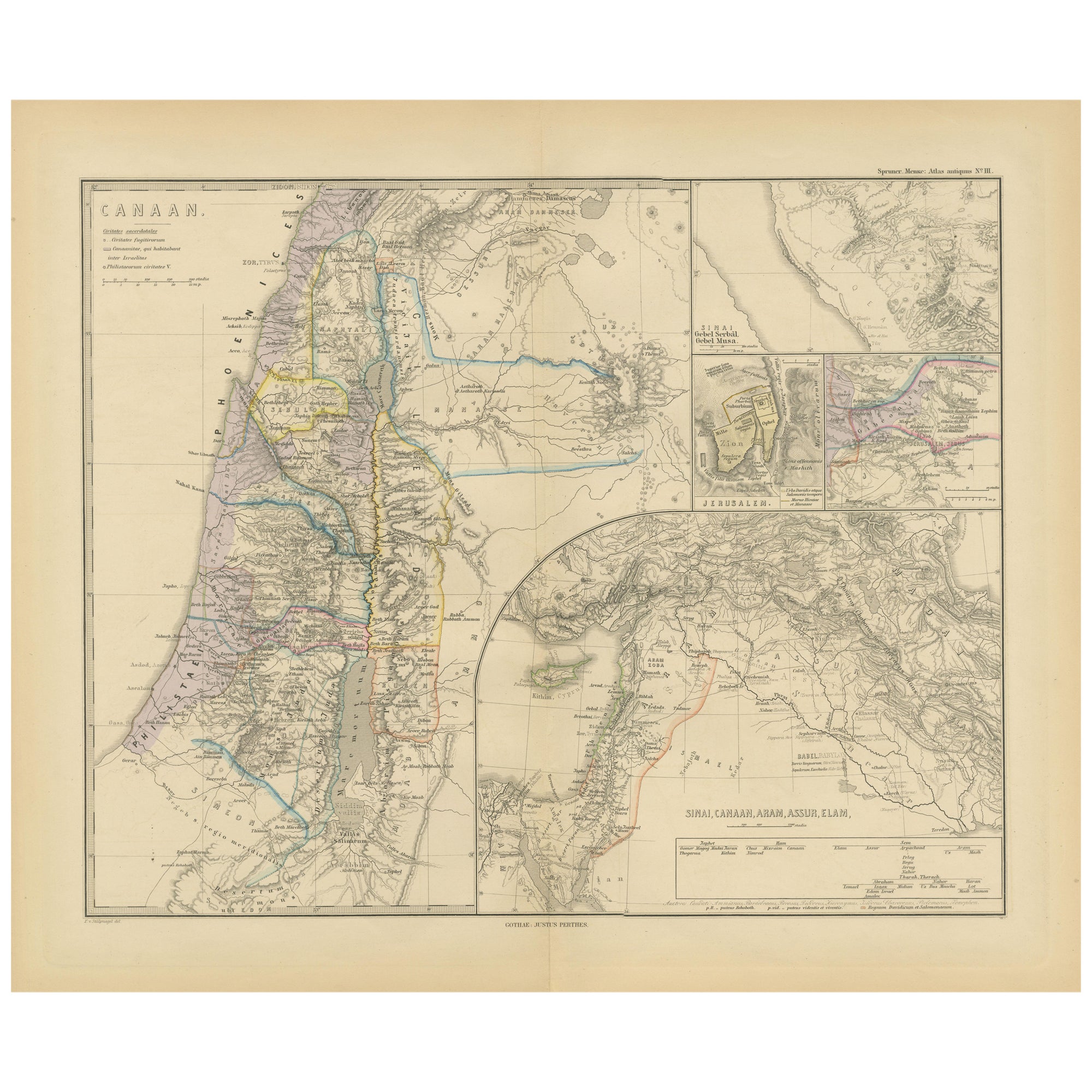
The map is titled "PHOENICE, COELESYRIA, IDUMAEA, JUDAEA MACCABAEORUM TEMPORE," which translates to "Phoenicia, Coele-Syria, Idumea, Judea at the Time of the Maccabees."
This original antique map is a rich historical document for several reasons:
1. **Historical Regions**: It includes Phoenicia, known for its seafaring and trading prowess; Coele-Syria, a region often contested between the Seleucid Empire and the Ptolemaic Empire; Idumea, the region inhabited by the Edomites; and Judea, the Jewish homeland during the time of the Maccabees.
2. **Inset Maps**: The map features inset maps of significant historical areas such as Hierosolyma (Jerusalem) and Galilaea (Galilee), providing detailed views of these important locations.
3. **Ancient Civilizations**: It encompasses the crossroads of ancient civilizations, reflecting the cultural, political, and military complexities of the Eastern Mediterranean.
4. **Latin Names**: The use of Latin nomenclature for place names aligns with scholarly traditions of the time when the map was created, emphasizing its educational and historical value.
5. **Detailed Geography**: The map shows detailed topographical features, including mountains, valleys, and the eastern Mediterranean coast.
6. **Historical Context**: The time of the Maccabees, indicated in the title, refers to a period of Jewish history characterized by revolt against Hellenistic influence and the establishment of the Hasmonean dynasty.
This period corresponds to the 2nd and 1st centuries BC, a time of great historical significance due to the cultural and political shifts in Judea and the surrounding regions. The map would be particularly valuable to those interested in the history of the Levant and the Hellenistic period.
This map is from the "Spruner-Menke Atlas Antiquus," a historical atlas compiled by German cartographer Karl Spruner von Merz and later edited by Theodorus Menke. The atlas is known for its detailed maps of the ancient world, intended for educational and scholarly use, and was published in the late 19th century.
- Dimensions:Height: 15.56 in (39.5 cm)Width: 18.51 in (47 cm)Depth: 0 in (0.02 mm)
- Materials and Techniques:
- Period:
- Date of Manufacture:1880
- Condition:Good, given age. General age-related toning, especially around the edges. vertical folding line as issued. Please study scan carefully.
- Seller Location:Langweer, NL
- Reference Number:Seller: BG-13686-2-201stDibs: LU3054338557652
About the Seller
5.0
Recognized Seller
These prestigious sellers are industry leaders and represent the highest echelon for item quality and design.
Platinum Seller
Premium sellers with a 4.7+ rating and 24-hour response times
Established in 2009
1stDibs seller since 2017
2,513 sales on 1stDibs
Typical response time: <1 hour
- ShippingRetrieving quote...Shipping from: Langweer, Netherlands
- Return Policy
Authenticity Guarantee
In the unlikely event there’s an issue with an item’s authenticity, contact us within 1 year for a full refund. DetailsMoney-Back Guarantee
If your item is not as described, is damaged in transit, or does not arrive, contact us within 7 days for a full refund. Details24-Hour Cancellation
You have a 24-hour grace period in which to reconsider your purchase, with no questions asked.Vetted Professional Sellers
Our world-class sellers must adhere to strict standards for service and quality, maintaining the integrity of our listings.Price-Match Guarantee
If you find that a seller listed the same item for a lower price elsewhere, we’ll match it.Trusted Global Delivery
Our best-in-class carrier network provides specialized shipping options worldwide, including custom delivery.More From This Seller
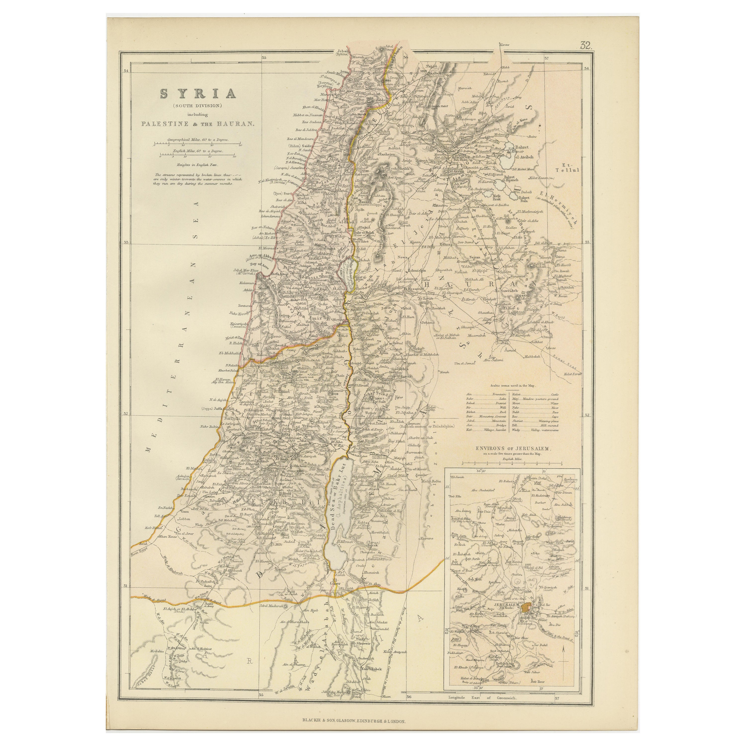
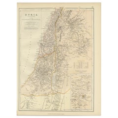
View AllAn Insightful 19th Century Map of Syria and the Surrounding Regions, 1882
Located in Langweer, NL
This map, titled "SYRIA (SOUTH DIVISION) including PALESTINE & THE HAUARAN," is a historical cartographic work from the late 19th century, specifically from the 1882 atlas by Blackie...
Category
Antique 1880s Maps
Materials
Paper
$264 Sale Price
20% Off
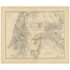
Historical Map of Canaan with Insets of Jerusalem and Surrounding Regions, 1880
Located in Langweer, NL
The map titled "CANAAN" depicts the historical region known as Canaan, located in the Levant, which corresponds to modern-day Israel, Palestinian territories, Lebanon, and parts of S...
Category
Antique 1880s Maps
Materials
Paper
$349 Sale Price
20% Off
Free Shipping
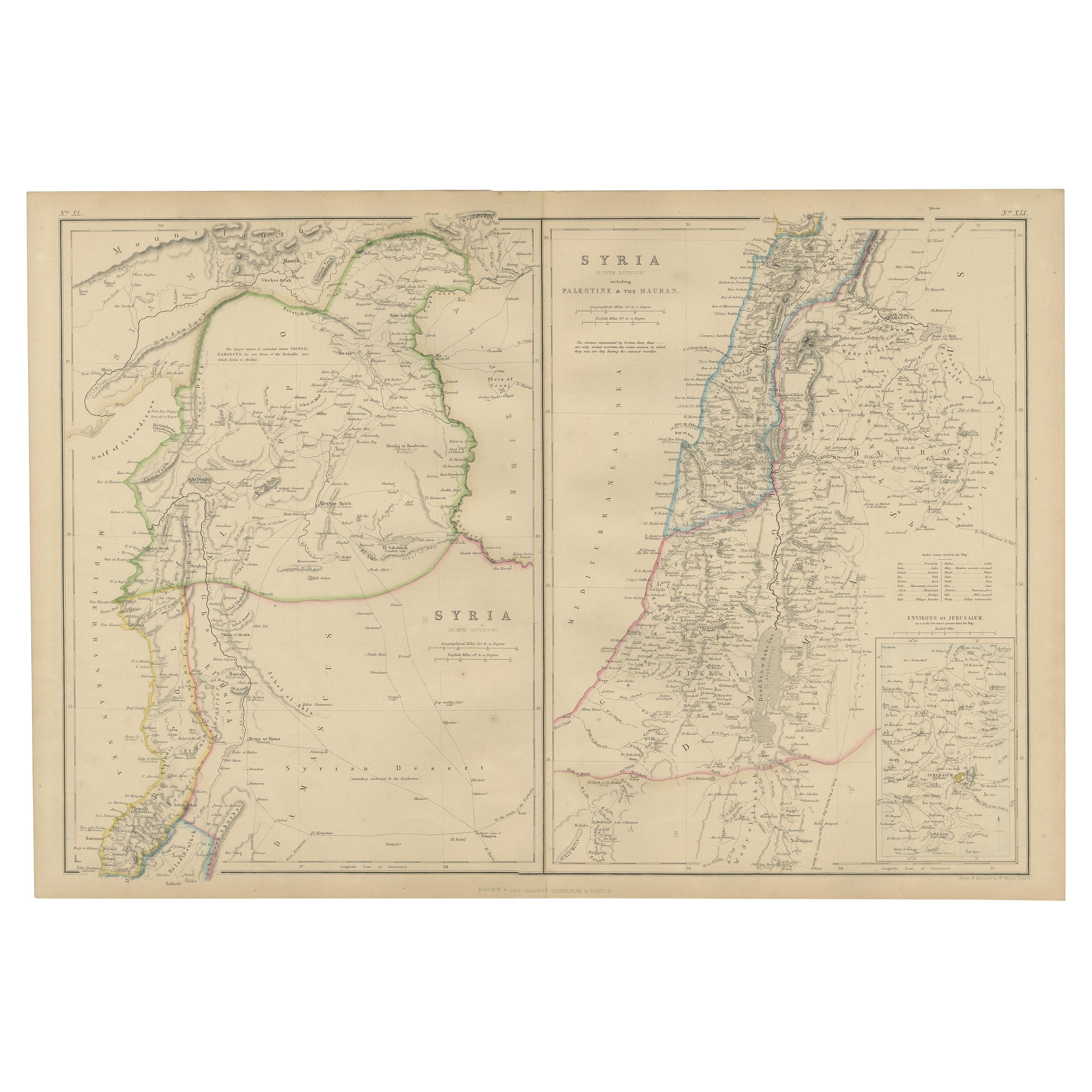
The Divided Realms of Syria - North and South as Seen in 1859 by W. G. Blackie
Located in Langweer, NL
The "Antique Map of Syria, North and South Division" by W. G. Blackie, dated 1859, is a significant historical cartographic work. This map, originating fr...
Category
Antique Mid-19th Century Maps
Materials
Paper

$236 Sale Price
20% Off
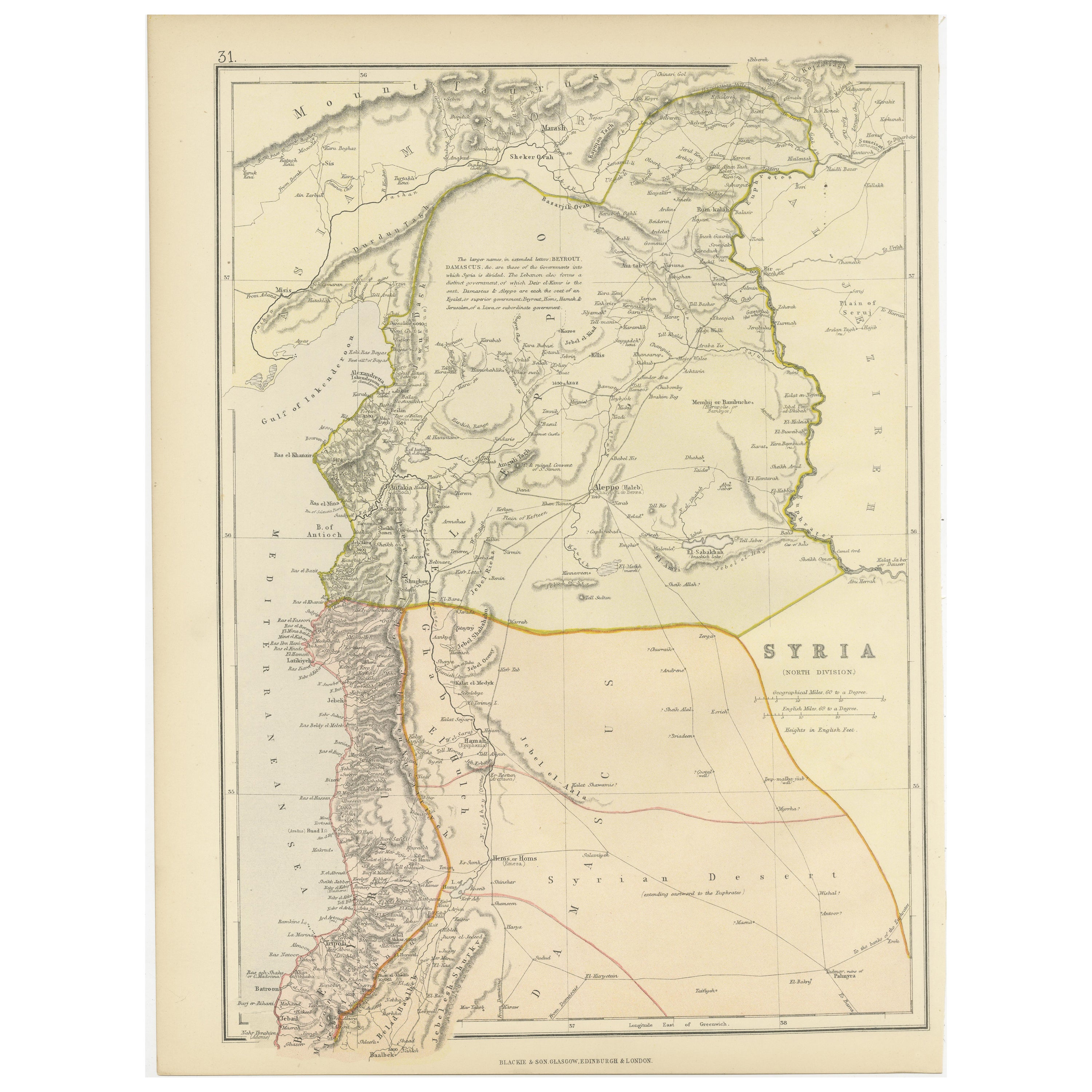
Territories of Antiquity: The Northern Division of Syria, A Detailed 1882 Map
Located in Langweer, NL
This 19th-century map from the atlas published by Blackie and Son in 1882 is titled "SYRIA (NORTH DIVISION)" and covers the northern part of Syria, capturing its geographical and adm...
Category
Antique 1880s Maps
Materials
Paper

$264 Sale Price
20% Off
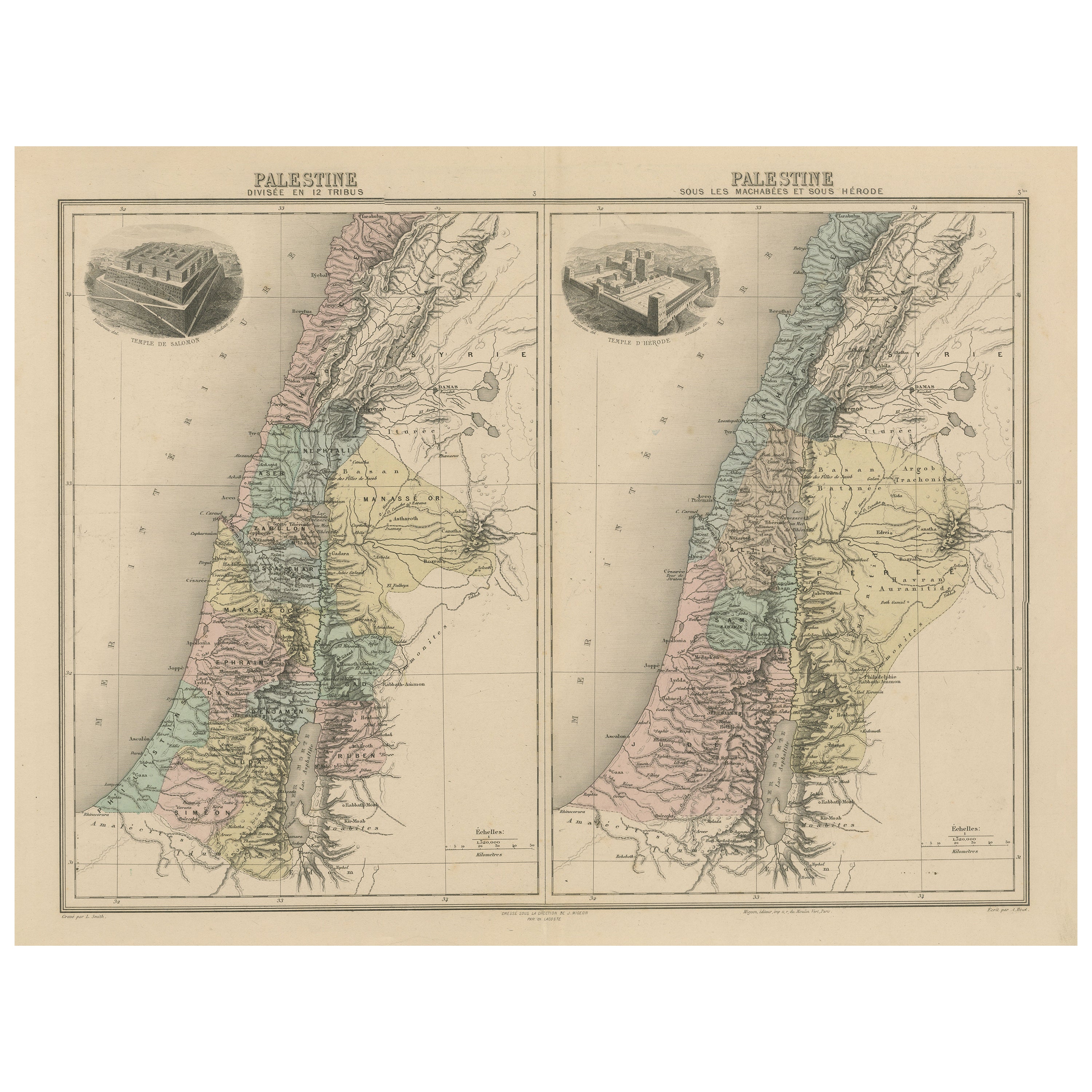
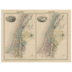
Palestine: Tribes & Maccabees – Antique Map by Migeon, Paris, 1892
Located in Langweer, NL
Palestine Divided into Tribes & Under the Maccabees – Antique Map by Migeon, 1892
This detailed antique map features two historical views of the Holy Land side by side: Palestine di...
Category
Antique Late 19th Century Maps
Materials
Paper
$321 Sale Price
20% Off
Antique Map of Egypt and Palestina by H. Kiepert 'circa 1870'
By Heinrich Kiepert
Located in Langweer, NL
Antique map titled 'Aegyptus, Phoenice et Palestina'. With inset maps of Tyrus, Alexandria and Hierosolyma. This map originates from 'Atlas Antiquus. Zwölf Karten zur Alten Geschicht...
Category
Antique Late 19th Century Maps
Materials
Paper

$151 Sale Price
20% Off
You May Also Like
Map of the Holy Land "Carte de la Syrie et de l'Egypte" by Pierre M. Lapie
By Pierre M. Lapie
Located in Alamo, CA
An early 19th century map of ancient Syria and Egypt entitled "Carte de la Syrie et de l'Egypte anciennes/dressée par M. Lapie, Colonel d'Etat Major, et...
Category
Antique Early 19th Century French Maps
Materials
Paper

Map of the Holy Land "Carte de la Syrie et de l'Egypte" by Pierre Lapie
By Pierre M. Lapie
Located in Alamo, CA
This is an early 19th century map of ancient Syria and Egypt entitled "Carte de la Syrie et de l'Egypte anciennes/dressée par M. Lapie, Colonel d'Etat M...
Category
1830s Landscape Prints
Materials
Engraving

Circa 1825 original engraving of the map of Syria by Giraldon Bovinet
Located in PARIS, FR
The circa 1825 original engraving of "Syrie" by Giraldon Bovinet, based on the work of L. Vivien, is a historically significant map that reflects early 19th-century cartographic tech...
Category
1820s Prints and Multiples
Materials
Engraving, Paper

Large Original Vintage Map of Israel, circa 1920
Located in St Annes, Lancashire
Great map of Israel
Original color.
Good condition
Published by Alexander Gross
Unframed.
Category
Vintage 1920s English Edwardian Maps
Materials
Paper

Original Antique Map of Ancient Greece, Achaia, Corinth, 1786
Located in St Annes, Lancashire
Great map of Ancient Greece. Showing the region of Thessaly, including Mount Olympus
Drawn by J.D. Barbie Du Bocage
Copper plate engraving by P.F Tardieu
Original hand color...
Category
Antique 1780s French Other Maps
Materials
Paper

Large Original Antique Map of Cyprus. 1894
Located in St Annes, Lancashire
Superb Antique map of Cyprus
Published Edward Stanford, Charing Cross, London 1894
Original colour
Good condition
Unframed.
Free shipping
Category
Antique 1890s English Maps
Materials
Paper

More Ways To Browse
Vintage Wood Table With Glass Top
19th Century Square Table
Galle Chairs
Large Chinese Rug
1940s Vintage French Art Deco
20th Century Spanish Table
Antonio Bellini
Retro Fiberglass Furniture
Shipping Crate
Antique Oushak Carpets
Blue Coffee Tables
German Bauhaus Posters
1945 Chair Juhl
Antique Three Leg Table
Folke Arstrom
Silver Over Copper
Vintage Barware Glasses
Antique Etched Glass