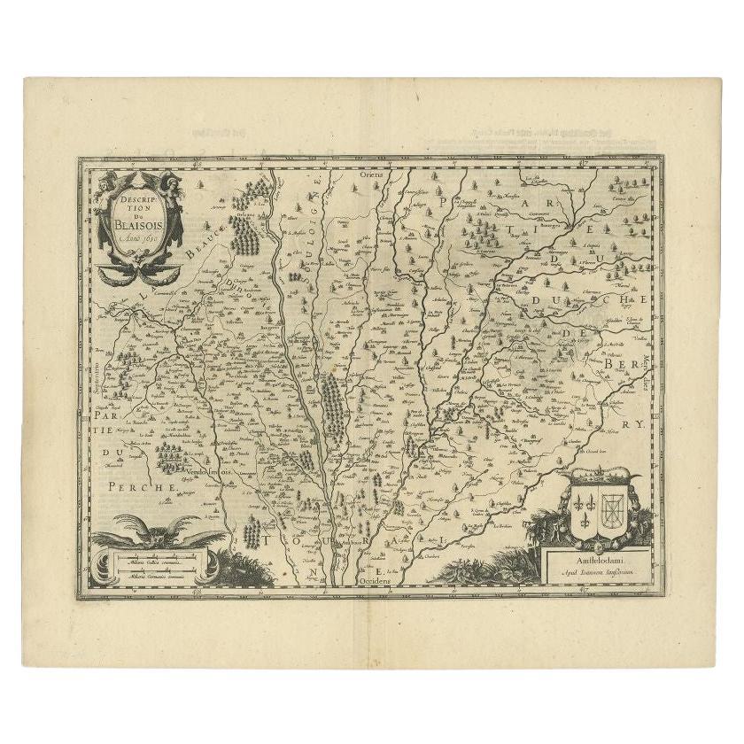
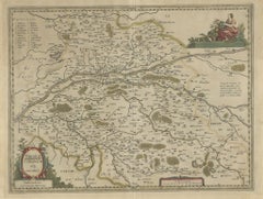
Items Similar to Map of Blaisois by Janssonius, 1633, Decorative Antique Map of Loire Valley

Want more images or videos?
Request additional images or videos from the seller
1 of 10
Map of Blaisois by Janssonius, 1633, Decorative Antique Map of Loire Valley
$512.68
£386.66
€440
CA$708.83
A$794.01
CHF 417.04
MX$9,654.91
NOK 5,281.12
SEK 5,013.21
DKK 3,349.57
About the Item
Map of Blaisois by Janssonius, 1633, Decorative Antique Map of Loire Valley
This finely detailed and colorfully embellished map titled 'Description du Blaisois' was published in 1633 by Johannes Janssonius in Amsterdam. It offers a rich topographical view of the Blaisois region in central France, centering around the historic city of Blois and its surrounding towns. The map is part of the renowned series of provincial French maps featured in Janssonius’s early 17th-century atlases.
Blaisois, located along the Loire River, is historically significant as a royal domain and a seat of French nobility. The map captures the strategic importance of this area, showing rivers, woodlands, and numerous towns in careful detail. Key neighboring regions such as Touraine, Berry, Perche, and Beauce are also represented. The engraving emphasizes the Loire Valley’s natural and political landscape as it appeared before the French Revolution.
This map is highly decorative, with an ornate title cartouche in the upper left corner marked “Anno 1630,” flanked by allegorical figures. A large coat of arms adorns the lower right, featuring heraldic symbols of the region. In the lower left, a secondary cartouche with a sea eagle and decorative foliage provides publication details. The hand coloring, now softly aged, enhances the map’s historic elegance.
Johannes Janssonius (1588–1664), a Dutch cartographer and publisher, was a contemporary and collaborator of Henricus Hondius. His work is known for its high aesthetic quality, cartographic precision, and embellishments. This map is a superb example of Dutch Golden Age cartography and offers both historical insight and decorative appeal.
Condition Report:
Good condition. Hand-colored copper engraving. Some toning to the paper edges and a water stain in the lower right margin, not affecting the engraved area. Fold line visible but stable. Plate still crisp with full margins.
Framing Tips:
This piece benefits from a classic gold or dark wood frame, with a soft cream or parchment-colored mat to match the antique tones. Consider floating the map with visible platemarks or matting to the edge of the engraving for a cleaner presentation. Use UV-protective glazing to preserve the original coloring.
Keywords:
Blaisois antique map, Blois map 1633, Janssonius map France, Loire Valley map, early French cartography, 17th century French map, decorative antique map, Dutch golden age engraving, Janssonius atlas, Touraine Berry Blaisois, pre-revolution France, copper engraved map, hand-colored map France, vintage Loire region print, historical French provinces map.
- Dimensions:Height: 18.9 in (48 cm)Width: 22.64 in (57.5 cm)Depth: 0.01 in (0.2 mm)
- Materials and Techniques:Paper,Engraved
- Period:1630-1639
- Date of Manufacture:circa 1633
- Condition:Good condition. Hand-colored copper engraving. Some overal toning, especially to the paper edges and a water stain in the lower right margin, not affecting the engraved area. Fold line visible but stable. Plate still crisp with full margins.
- Seller Location:Langweer, NL
- Reference Number:Seller: BG-14065-31stDibs: LU3054345049612
About the Seller
5.0
Recognized Seller
These prestigious sellers are industry leaders and represent the highest echelon for item quality and design.
Platinum Seller
Premium sellers with a 4.7+ rating and 24-hour response times
Established in 2009
1stDibs seller since 2017
2,517 sales on 1stDibs
Typical response time: <1 hour
- ShippingRetrieving quote...Shipping from: Langweer, Netherlands
- Return Policy
Authenticity Guarantee
In the unlikely event there’s an issue with an item’s authenticity, contact us within 1 year for a full refund. DetailsMoney-Back Guarantee
If your item is not as described, is damaged in transit, or does not arrive, contact us within 7 days for a full refund. Details24-Hour Cancellation
You have a 24-hour grace period in which to reconsider your purchase, with no questions asked.Vetted Professional Sellers
Our world-class sellers must adhere to strict standards for service and quality, maintaining the integrity of our listings.Price-Match Guarantee
If you find that a seller listed the same item for a lower price elsewhere, we’ll match it.Trusted Global Delivery
Our best-in-class carrier network provides specialized shipping options worldwide, including custom delivery.More From This Seller
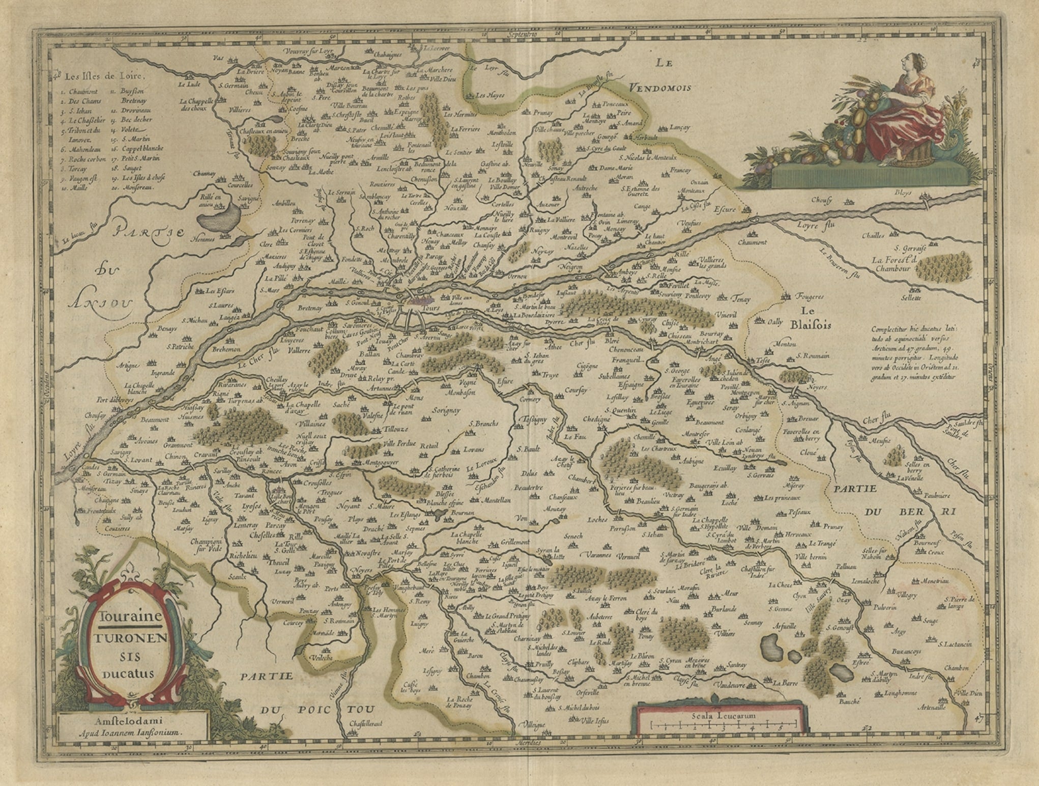
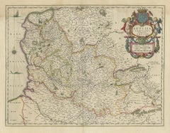
View AllAntique Map of the Region of Touraine in France by Janssonius, 1657
By Johannes Janssonius
Located in Langweer, NL
Antique map titled 'Touraine - Turonensis Ducatus'.
Decorative map of the Touraine region. This map originates from 'Atlas Novus, Sive Theatrum Orbis Orbis Terrarum: In quo Galli...
Category
Antique 17th Century Maps
Materials
Paper
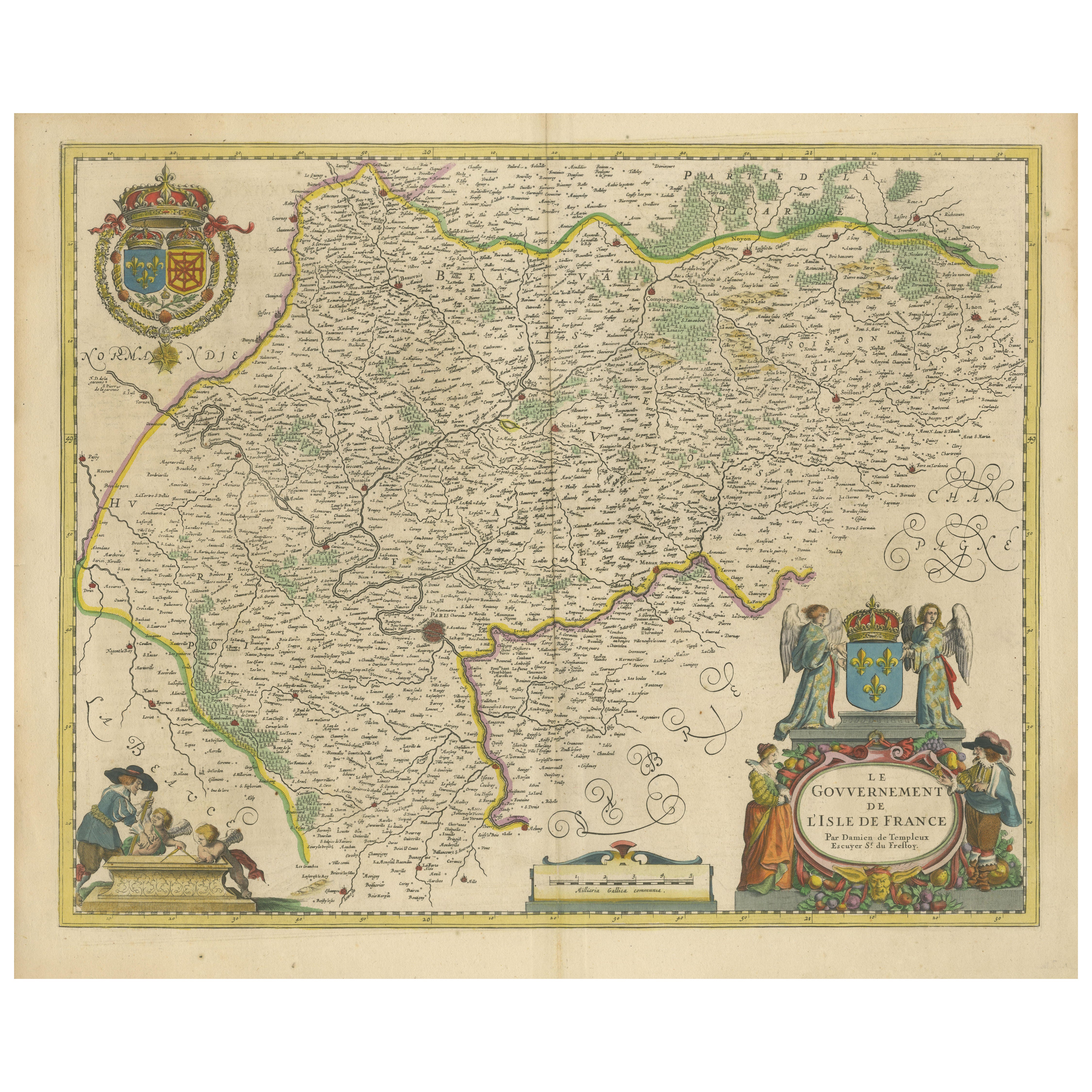
Beautiful 17th Century Map of Paris and Isle de France by Templeux, c.1650
Located in Langweer, NL
Map of Isle de France by D. de Templeux, ca. 1650, Hand-Colored and Decorative
This richly detailed antique map titled *Le Gouvernement de L'Isle de France* was engraved by Daniel d...
Category
Antique 1650s Maps
Materials
Paper

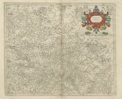
Antique Map of the Region of Blois by Janssonius, 'circa 1640'
By Johannes Janssonius
Located in Langweer, NL
Antique map titled 'Description du Blaisois'. Old map of the region of Blois, France. It shows the city of Blois, Amboise, the Loire River and more. Published by J. Janssonius, circa...
Category
Antique Mid-17th Century Maps
Materials
Paper

$378 Sale Price
35% Off
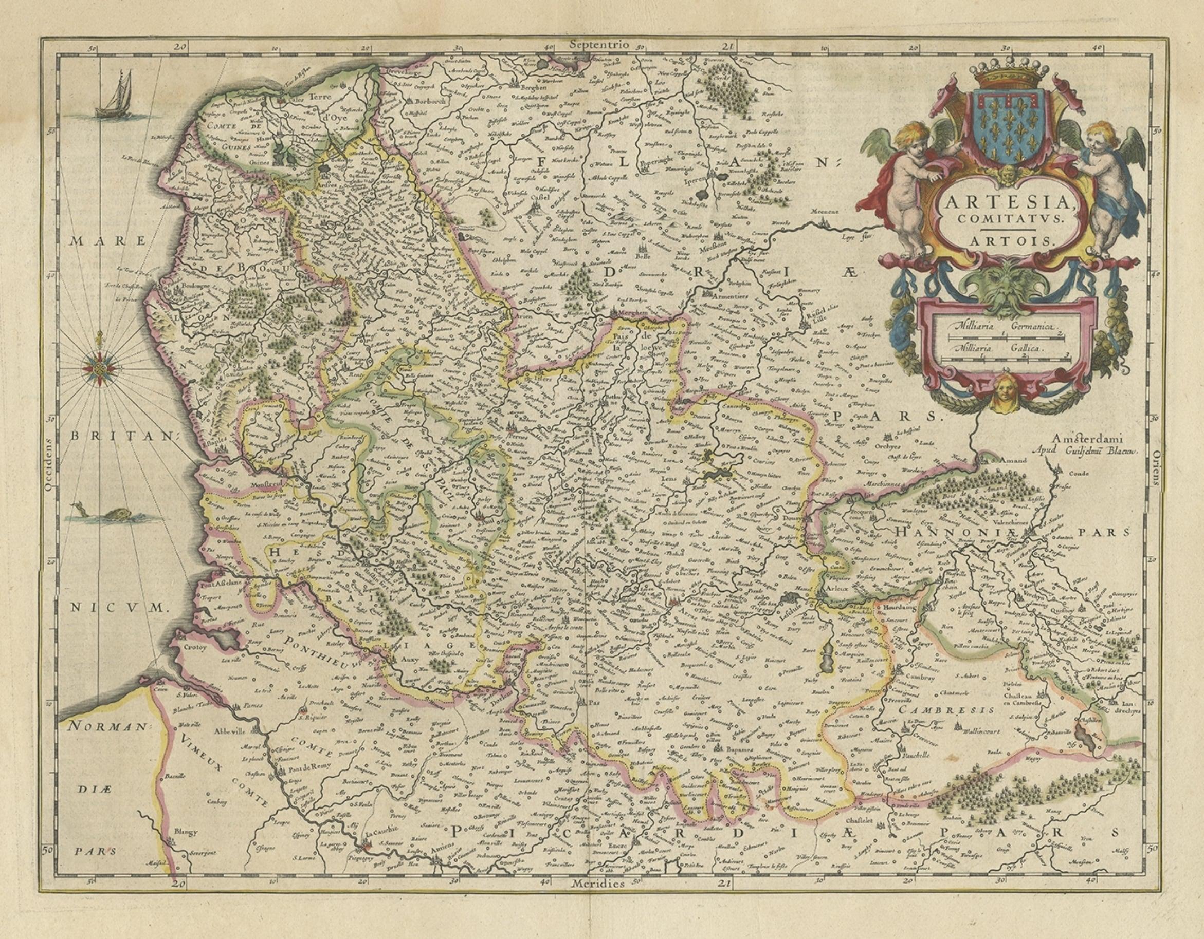
Antique Map of Artois in the North of France by Famous Mapmaker Blaeu, c.1640
Located in Langweer, NL
Antique map titled 'Artesia Comitatus Artois'. Map of Artois or Artesia, France. Artois is former province located in the northwestern part of France, boarding Belgium (Flanders) on ...
Category
Antique 17th Century Maps
Materials
Paper
$447 Sale Price
20% Off
Antique Map of the Region of Blois by Janssonius, c.1650
Located in Langweer, NL
Antique map titled 'Description du Blaisois'. Old map of the region of Blois, France. It shows the city of Blois, Amboise, the Loire River and more.
Artists and Engravers: Johann...
Category
Antique 17th Century Maps
Materials
Paper

$291 Sale Price
20% Off
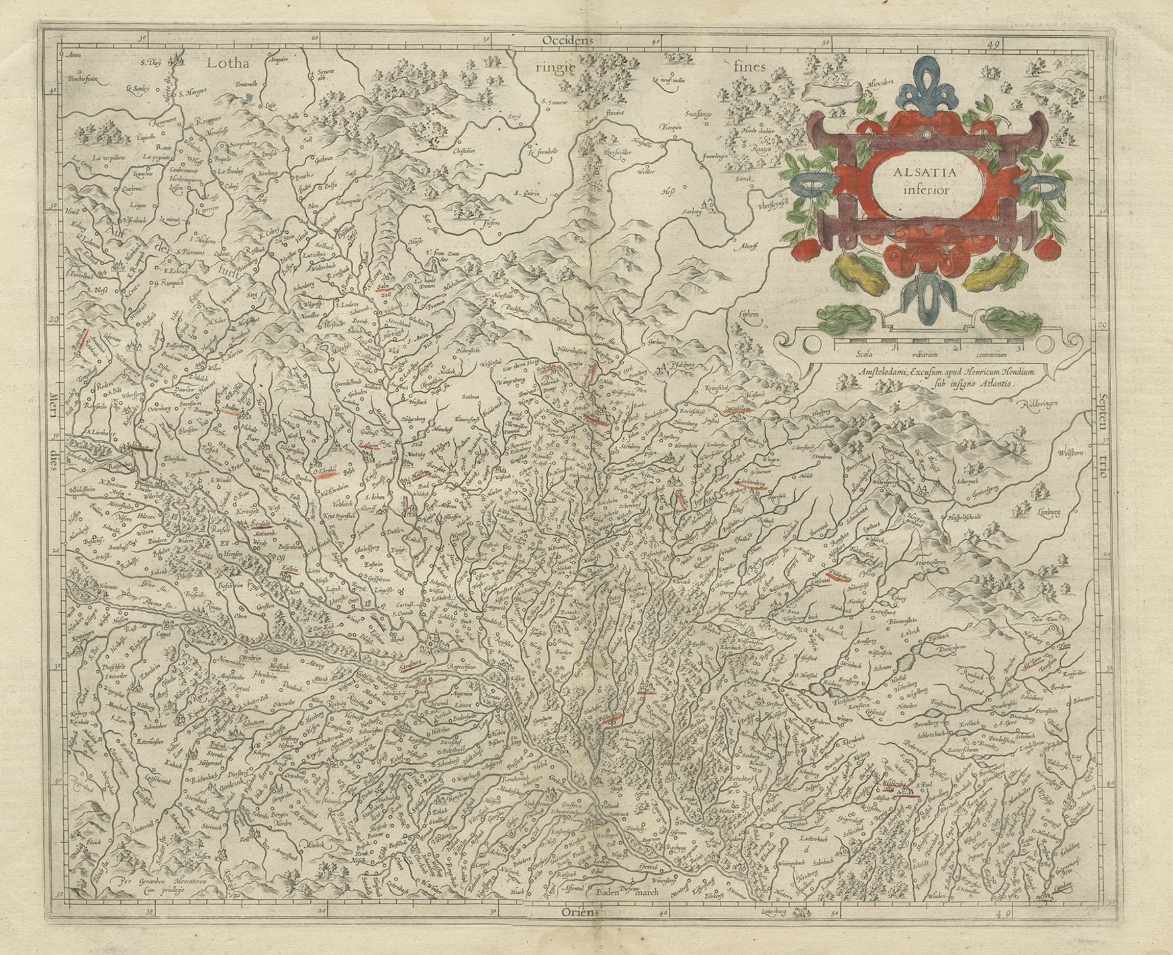
Antique Map of the Lower Alsace Region of France by Mapmaker Hondius, c.1630
Located in Langweer, NL
Antique map titled 'Alsatia Inferior'. Original antique map of the northern Alsace (Elzas) region of France. The map is centered on the course of the Rhine River, with Strasbourg at ...
Category
Antique 17th Century Maps
Materials
Paper
You May Also Like
1640 Joan Bleau Map Entitled"Diocecese de rheims et le pais de rethel, " Eic.a011
Located in Norton, MA
1640 Joan Bleau map entitled
"Diocecese de rheims et le pais de rethel,"
Ric.a011
OAN BLAEU
Diocecese de Rheims, et le pais de Rethel.
Handcolored engraving, c.1640.
...
Category
Antique 17th Century Dutch Maps
Materials
Paper

The Loire Valley of France: A 17th C. Hand-colored Map by Sanson and Jaillot
By Nicholas Sanson d'Abbeville
Located in Alamo, CA
This large 17th century copper plate hand-colored engraved map entitled "Gouvernement D'Orleans et la Generalite divisee en ses Elections Par...
Category
1690s Landscape Prints
Materials
Engraving

1656 Jansson Map Metz Region of France Entitled "Territorium Metense" Ric0014
Located in Norton, MA
1656 Jansson map Metz Region of France entitled "Territorium Metense."
Ric0014
" Authentic" - Map of the historical region surrounding Metz, in Lorraine, France.
Oriented with ...
Category
Antique 17th Century Dutch Maps
Materials
Paper

17th Century Hand-Colored Map of a Region in West Germany by Janssonius
By Johannes Janssonius
Located in Alamo, CA
This attractive highly detailed 17th century original hand-colored map is entitled "Archiepiscopatus Maghdeburgensis et Anhaltinus Ducatus cum terris adjacentibus". It was published ...
Category
Antique Mid-17th Century Dutch Maps
Materials
Paper

1625 Mercator Map of the Provenience of Quercy, "Quercy Cadvrcivm Ric.0013
Located in Norton, MA
1625 Mercator map of the provenience of Quercy, entitled
"Quercy Cadvrcivm,"
Ric.0013
" Authentic" - Map of the provenience of Quercy Cadvrcivm
D...
Category
Antique 17th Century French Maps
Materials
Paper

1635 Willem Blaeu Map of Northern France"Comitatvs Bellovacvm" Ric.a08
Located in Norton, MA
1635 Willem Blaeu map of northern France, entitled.
"Comitatvs Bellovacvm Vernacule Beavvais,"
Colored
Ric.a008
“COMITATVS BELLOVACVM…” Amsterdam: W...
Category
Antique 17th Century Unknown Maps
Materials
Paper

More Ways To Browse
Royal Provincial
Coat Of Arms Engraving
Hand Colored Copper Engraving
Large Antique Copper Plate
French Matting
Used Domain Furniture
17th Century Dutch Wood Frames
Silver Bowl Large
Down Couch
Used Lighter Art
Blue Edge Glass
Mahogany 1950s Furniture
Solid Mahogany Table
Dessert Glasses
Geometric Glass Table
Mid Century Pin
6x10 Rug
Studded Furniture