Items Similar to Map of Brittany and Western France by Gerard Valk, circa 1690


Want more images or videos?
Request additional images or videos from the seller
1 of 10
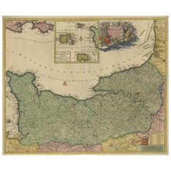
Map of Brittany and Western France by Gerard Valk, circa 1690
$923.37
£686.89
€770
CA$1,264.41
A$1,405.85
CHF 734.06
MX$17,112.59
NOK 9,366.24
SEK 8,775.72
DKK 5,861.58
Shipping
Retrieving quote...The 1stDibs Promise:
Authenticity Guarantee,
Money-Back Guarantee,
24-Hour Cancellation
About the Item
Map of Brittany and Western France by Gerard Valk, circa 1700
This finely detailed antique map, titled *Praefectura Ducatus Britanniae, Quae Superior et Inferior*, was created around 1700 by the Dutch cartographer Gerard Valk. It presents an expansive view of the Duchy of Brittany (Bretagne), historically one of the most culturally distinct and politically significant regions of France. The map reaches eastward to include major cities such as Nantes, Rennes, and Saint-Malo, showing the full extent of both Upper and Lower Brittany.
Gerard Valk (1652–1726) was a prominent mapmaker and globe manufacturer based in Amsterdam. He collaborated with Pieter Schenk and other leading Dutch engravers to publish a number of influential atlases and wall maps. Valk’s maps are known for their clarity, strong engraving technique, and elegant color schemes, and they remain highly desirable among collectors of early cartography.
This particular map displays the western peninsula of France in striking detail, with its rugged coastlines along the Atlantic Ocean, islands such as Belle-Île, and extensive inland geography. Administrative divisions are outlined in yellow and pink hand-coloring, clearly marking the boundaries of ecclesiastical and civil jurisdictions. Towns, rivers, forests, and roadways are all carefully engraved, creating a layered and accurate representation of the region as it stood at the dawn of the 18th century.
The map includes references to bishoprics and archbishoprics, underlining the strong ecclesiastical structure of the region. Its Latin title and classical labeling reflect the scholarly nature of maps in this period, serving both practical and educational purposes.
As a historical object, this map captures a time just before the unification and modernization of the French administrative system. Brittany still retained elements of its medieval autonomy and cultural identity, especially through its language, customs, and religious institutions.
Condition summary:
Good condition with original hand-coloring. Centerfold as issued. Slight toning at edges, but overall crisp and well-preserved. Strong paper.
Framing tips:
Best suited for a gold or dark wood frame with a warm off-white or ivory mat. This will enhance the classical feel and draw out the color contrast. Use museum glass to preserve the detail and reduce glare.
- Dimensions:Height: 20.36 in (51.7 cm)Width: 23.82 in (60.5 cm)Depth: 0.01 in (0.2 mm)
- Materials and Techniques:Paper,Engraved
- Place of Origin:
- Period:Late 17th Century
- Date of Manufacture:circa 1690
- Condition:Good condition with original hand-coloring. Centerfold as issued. Slight toning at edges, but overall crisp and well-preserved. Strong paper.
- Seller Location:Langweer, NL
- Reference Number:Seller: BG-13732-61stDibs: LU3054345364142
About the Seller
5.0
Recognized Seller
These prestigious sellers are industry leaders and represent the highest echelon for item quality and design.
Platinum Seller
Premium sellers with a 4.7+ rating and 24-hour response times
Established in 2009
1stDibs seller since 2017
2,510 sales on 1stDibs
Typical response time: <1 hour
- ShippingRetrieving quote...Shipping from: Langweer, Netherlands
- Return Policy
Authenticity Guarantee
In the unlikely event there’s an issue with an item’s authenticity, contact us within 1 year for a full refund. DetailsMoney-Back Guarantee
If your item is not as described, is damaged in transit, or does not arrive, contact us within 7 days for a full refund. Details24-Hour Cancellation
You have a 24-hour grace period in which to reconsider your purchase, with no questions asked.Vetted Professional Sellers
Our world-class sellers must adhere to strict standards for service and quality, maintaining the integrity of our listings.Price-Match Guarantee
If you find that a seller listed the same item for a lower price elsewhere, we’ll match it.Trusted Global Delivery
Our best-in-class carrier network provides specialized shipping options worldwide, including custom delivery.More From This Seller
View AllRare Hand-Colored Map of Lorraine and Barrois, France by Frederik De Wit c. 1688
Located in Langweer, NL
Title: Rare Hand-Colored Map of Lorraine and Barrois by Frederik De Wit c. 1688
Description: This remarkable 17th-century map, titled "Generalis Lotharingiae Ducatus," offers a deta...
Category
Antique 1680s Maps
Materials
Paper

Beautiful 17th Century Map of Paris and Isle de France by Templeux, c.1650
Located in Langweer, NL
Map of Isle de France by D. de Templeux, ca. 1650, Hand-Colored and Decorative
This richly detailed antique map titled *Le Gouvernement de L'Isle de France* was engraved by Daniel d...
Category
Antique 1650s Maps
Materials
Paper

Original Normandy Map by Frederick de Wit, 1705, with Inset of Channel Islands
Located in Langweer, NL
Normandy Map by Frederick de Wit, 1705, with Inset of Channel Islands
Description:
This beautifully engraved and hand-colored map, titled Duché et Gouvernement General de Normandie,...
Category
Antique Early 1700s Maps
Materials
Paper
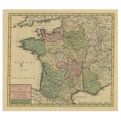
Antique Map of France by Tirion, c.1740
Located in Langweer, NL
Antique map titled 'Nieuwe Kaart van Frankryk.' - Attractive detailed map showing France. Title in block-style cartouche with a simple compass rose. Source unknown, to be determined....
Category
Antique 18th Century Maps
Materials
Paper
$431 Sale Price
20% Off
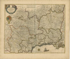
Stunning Hand-Colored Map of Languedoc in France by Frederik De Wit c. 1688
Located in Langweer, NL
Title: Stunning Hand-Colored Map of Languedoc by Frederik De Wit c. 1688
Description: This elegant 17th-century map, "Gouvernement General de Languedoc," beautifully illustrates the...
Category
Antique 1680s Maps
Materials
Paper
Antique Map of France by Mortier 'c.1730'
Located in Langweer, NL
Antique map titled 'Galliae Antiquae Tabula'. Original antique map of France in ancient times. Published by P. Mortier, circa 1730.
Category
Antique Mid-18th Century Maps
Materials
Paper

$1,079 Sale Price
25% Off
You May Also Like
The Normandy Region of France: A 17th C. Hand-colored Map by Sanson and Jaillot
By Nicolas Sanson
Located in Alamo, CA
This large hand-colored map entitled "Le Duché et Gouvernement de Normandie divisée en Haute et Basse Normandie en divers Pays; et par evêchez, avec le Gouvernement General du Havre ...
Category
Antique 1690s French Maps
Materials
Paper

1640 Joan Bleau Map Entitled"Diocecese de rheims et le pais de rethel, " Eic.a011
Located in Norton, MA
1640 Joan Bleau map entitled
"Diocecese de rheims et le pais de rethel,"
Ric.a011
OAN BLAEU
Diocecese de Rheims, et le pais de Rethel.
Handcolored engraving, c.1640.
...
Category
Antique 17th Century Dutch Maps
Materials
Paper

1752 Vaugoundy Map of Flanders : Belgium, France, and the Netherlands, Ric.a002
Located in Norton, MA
Large Vaugoundy Map of Flanders:
Belgium, France, and the Netherlands
Colored -1752
Ric.a002
Description: This is a 1752 Didier Robert de Vaugondy map of Flanders. The map de...
Category
Antique 17th Century Unknown Maps
Materials
Paper

The Normandy Region of France: A 17th C. Hand-colored Map by Sanson and Jaillot
By Nicholas Sanson d'Abbeville
Located in Alamo, CA
This large hand-colored map entitled "Le Duché et Gouvernement de Normandie divisée en Haute et Basse Normandie en divers Pays; et par evêchez, avec le Gouvernement General du Havre ...
Category
1690s Landscape Prints
Materials
Engraving

1771 Bonne Map of Poitou, Touraine and Anjou, France, Ric.a015
Located in Norton, MA
1771 Bonne Map of Poitou,
Touraine and Anjou, France
Ric.a015
1771 Bonne map of Potiou, Touraine and Anjou entitled "Carte des Gouvernements D'Anjou et du Saumurois, de la Touraine, du Poitou,du Pays d'aunis, Saintonge?Angoumois,"
Carte des gouvernements d'Anjou et du Saumurois, de la Touraine, du Poitou, du Pays d'Aunis, Saintonge-Angoumois. Projettee et assujettie au ciel par M. Bonne, Hyd. du Roi. A Paris, Chez Lattre, rue St. Jacques a la Ville de Bord(ea)ux. Avec priv. du Roi. 1771. Arrivet inv. & sculp., Atlas moderne ou collection de cartes sur toutes...
Category
Antique 17th Century Unknown Maps
Materials
Paper

1635 Willem Blaeu Map of Northern France"Comitatvs Bellovacvm" Ric.a08
Located in Norton, MA
1635 Willem Blaeu map of northern France, entitled.
"Comitatvs Bellovacvm Vernacule Beavvais,"
Colored
Ric.a008
“COMITATVS BELLOVACVM…” Amsterdam: W...
Category
Antique 17th Century Unknown Maps
Materials
Paper

More Ways To Browse
Antique Brittany
French Brittany Furniture
Antique Ivory Collectables
Brittany Furniture
Brittany Antique Furniture
17th Century Dutch Wood Frames
Styles Of Antique Desks
Black And White Coffee Table
Curved Velvet Couch
Velvet Curved Sofa
Wood Round Coffee Tables
Antique Paper Flowers
Oak Brutalist
Used College Furniture
Wood Minimalist Chair
2002 Lamp
Antique Imperial Furniture
Gold Modern Coffee Table