Items Similar to Map of Languedoc by Willem Blaeu, Antique French Copper Engraving 1635


Want more images or videos?
Request additional images or videos from the seller
1 of 10
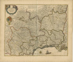
Map of Languedoc by Willem Blaeu, Antique French Copper Engraving 1635
$1,122.38
£841.29
€950
CA$1,541.96
A$1,721.45
CHF 902.02
MX$21,072.27
NOK 11,455.60
SEK 10,801.18
DKK 7,231.75
About the Item
Map of Languedoc by Willem Blaeu, Antique French Copper Engraving 1635
This fine antique map titled "Langvedoc" depicts the historical province of Languedoc in southern France and was produced by Willem Blaeu, one of the most celebrated Dutch cartographers of the 17th century. Originally published in 1631, this specific edition dates from 1635 and was issued as part of Blaeu’s renowned atlas series, Theatrum Orbis Terrarum.
Engraved in copper and delicately hand-colored, the map showcases the region's complex network of towns, rivers, mountain ranges, and coastline along the Mediterranean Sea. Notable cities such as Montpellier, Nîmes, Béziers, and Carcassonne are clearly marked. The level of detail reflects both the cartographic skill and aesthetic ambition of the Blaeu publishing house.
The map is enriched with decorative elements typical of the period, including a large ornate title cartouche at upper left, flanked by cherubs and scrollwork. Beneath the cartouche, the royal coat of arms of France is prominently displayed, colored in vivid red, gold, and blue, underscoring the political affiliation of the region during the reign of Louis XIII. A mileage scale in the upper center and a compass rose in the Mediterranean further enhance the navigational and ornamental qualities of the work. A sailing ship adds charm and visual interest to the sea section.
Willem Blaeu, active in Amsterdam, was a master printer, publisher, and globe maker. His maps were not only among the most accurate of his time but also the most beautiful, combining scientific precision with artistic elegance. This map would have been included in an early Blaeu atlas, valued for both its information and its aesthetic appeal.
This is an exceptional example of early French regional cartography, ideal for collectors of antique maps or those with a connection to the Languedoc region.
Condition:
Good condition with age-toned paper, mainly edge wear, touching the image but mostly outside the plate mark. Old folds as issued.
Tips for Framing:
Best displayed in a classic gold or natural wood frame with an ivory or parchment-tone mat to complement the warm patina and hand-coloring of the map.
- Dimensions:Height: 19.3 in (49 cm)Width: 23.08 in (58.6 cm)Depth: 0 in (0.02 mm)
- Materials and Techniques:Paper,Engraved
- Period:1630-1639
- Date of Manufacture:circa 1635
- Condition:Engraving with original hand coloring. Good condition with age-toned paper, mainly edge wear, touching the image but mostly outside the plate mark. Old folds as issued. Study the images carefully.
- Seller Location:Langweer, NL
- Reference Number:Seller: BG-13732-41stDibs: LU3054345364182
About the Seller
5.0
Recognized Seller
These prestigious sellers are industry leaders and represent the highest echelon for item quality and design.
Platinum Seller
Premium sellers with a 4.7+ rating and 24-hour response times
Established in 2009
1stDibs seller since 2017
2,513 sales on 1stDibs
Typical response time: <1 hour
- ShippingRetrieving quote...Shipping from: Langweer, Netherlands
- Return Policy
Authenticity Guarantee
In the unlikely event there’s an issue with an item’s authenticity, contact us within 1 year for a full refund. DetailsMoney-Back Guarantee
If your item is not as described, is damaged in transit, or does not arrive, contact us within 7 days for a full refund. Details24-Hour Cancellation
You have a 24-hour grace period in which to reconsider your purchase, with no questions asked.Vetted Professional Sellers
Our world-class sellers must adhere to strict standards for service and quality, maintaining the integrity of our listings.Price-Match Guarantee
If you find that a seller listed the same item for a lower price elsewhere, we’ll match it.Trusted Global Delivery
Our best-in-class carrier network provides specialized shipping options worldwide, including custom delivery.More From This Seller
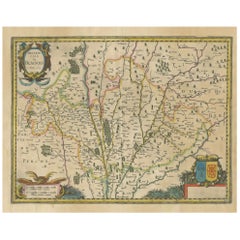
View AllStunning Hand-Colored Map of Languedoc in France by Frederik De Wit c. 1688
Located in Langweer, NL
Title: Stunning Hand-Colored Map of Languedoc by Frederik De Wit c. 1688
Description: This elegant 17th-century map, "Gouvernement General de Languedoc," beautifully illustrates the...
Category
Antique 1680s Maps
Materials
Paper
Map of Blaisois by Janssonius, 1633, Decorative Antique Map of Loire Valley
Located in Langweer, NL
Map of Blaisois by Janssonius, 1633, Decorative Antique Map of Loire Valley
This finely detailed and colorfully embellished map titled 'Description du Blaisois' was published in 163...
Category
Antique 1630s Maps
Materials
Paper
Map of the Provence in Southern France, Original Old Engraving by De Wit c. 1688
Located in Langweer, NL
Title: Provence Map - Hand-Colored 17th-Century Engraving by Frederik De Wit c. 1688
Description: This captivating map, "Gouvernement de Provence," depicts the Provence region of so...
Category
Antique 1680s Maps
Materials
Paper
Beautiful 17th Century Map of Paris and Isle de France by Templeux, c.1650
Located in Langweer, NL
Map of Isle de France by D. de Templeux, ca. 1650, Hand-Colored and Decorative
This richly detailed antique map titled *Le Gouvernement de L'Isle de France* was engraved by Daniel d...
Category
Antique 1650s Maps
Materials
Paper

Antique Map of Catalonia by Blaeu, circa 1650
Located in Langweer, NL
Antique map titled 'Catalonia'. Antique map of Catalonia, extending from C. De Romani on the Northern Coast to Alfachs and Panicola in Valencia on the southern end of the coast and s...
Category
Antique Mid-17th Century Maps
Materials
Paper

$850 Sale Price
20% Off
Antique Map of the Region of Lyon by Hondius, circa 1630
Located in Langweer, NL
Antique map titled 'Lionnois, Forest et Beauiolois'. Old map of the former region of Lyon, Vienne, Bresse, Rohan and the Rhône River. This map originates f...
Category
Antique Mid-17th Century Maps
Materials
Paper

$472 Sale Price
20% Off
You May Also Like
1635 Willem Blaeu Map of Northern France"Comitatvs Bellovacvm" Ric.a08
Located in Norton, MA
1635 Willem Blaeu map of northern France, entitled.
"Comitatvs Bellovacvm Vernacule Beavvais,"
Colored
Ric.a008
“COMITATVS BELLOVACVM…” Amsterdam: W...
Category
Antique 17th Century Unknown Maps
Materials
Paper

1640 Joan Bleau Map Entitled"Diocecese de rheims et le pais de rethel, " Eic.a011
Located in Norton, MA
1640 Joan Bleau map entitled
"Diocecese de rheims et le pais de rethel,"
Ric.a011
OAN BLAEU
Diocecese de Rheims, et le pais de Rethel.
Handcolored engraving, c.1640.
...
Category
Antique 17th Century Dutch Maps
Materials
Paper

1625 Mercator Map of the Provenience of Quercy, "Quercy Cadvrcivm Ric.0013
Located in Norton, MA
1625 Mercator map of the provenience of Quercy, entitled
"Quercy Cadvrcivm,"
Ric.0013
" Authentic" - Map of the provenience of Quercy Cadvrcivm
D...
Category
Antique 17th Century French Maps
Materials
Paper

Antique Map - Gallia - Etching by Johannes Janssonius - 1650s
By Johannes Janssonius
Located in Roma, IT
Antique Map - Gallia is an antique map realized in 1650 by Johannes Janssonius (1588-1664).
The Map is Hand-colored etching, with coeval watercoloring.
Good conditions with slight ...
Category
1650s Modern Figurative Prints
Materials
Etching

1656 Jansson Map Metz Region of France Entitled "Territorium Metense" Ric0014
Located in Norton, MA
1656 Jansson map Metz Region of France entitled "Territorium Metense."
Ric0014
" Authentic" - Map of the historical region surrounding Metz, in Lorraine, France.
Oriented with ...
Category
Antique 17th Century Dutch Maps
Materials
Paper

Ancient Map - Macedonia - Etching by Johannes Janssonius - 1650s
By Johannes Janssonius
Located in Roma, IT
Macedonia is an ancient map realized in 1650 by Johannes Janssonius (1588-1664).
The Map is Hand-colored etching, with coeval watercoloring.
Good condit...
Category
1650s Modern Figurative Prints
Materials
Etching

More Ways To Browse
Antique Copper Engravings
Classic Engraving
Antique Compasses
Antique Ivory Collectables
Coat Of Arms Engraving
Antique Copper Scale
Hand Colored Copper Engraving
Cherub Charm
Large Antique Copper Plate
Dutch Sailing Ship
17th Century Dutch Wood Frames
Antique Gold Compass
Compass Rose Gold
Styles Of Antique Desks
Black And White Coffee Table
Curved Velvet Couch
Velvet Curved Sofa
Wood Round Coffee Tables