Items Similar to Map of the Republic of Genoa

Want more images or videos?
Request additional images or videos from the seller
1 of 5
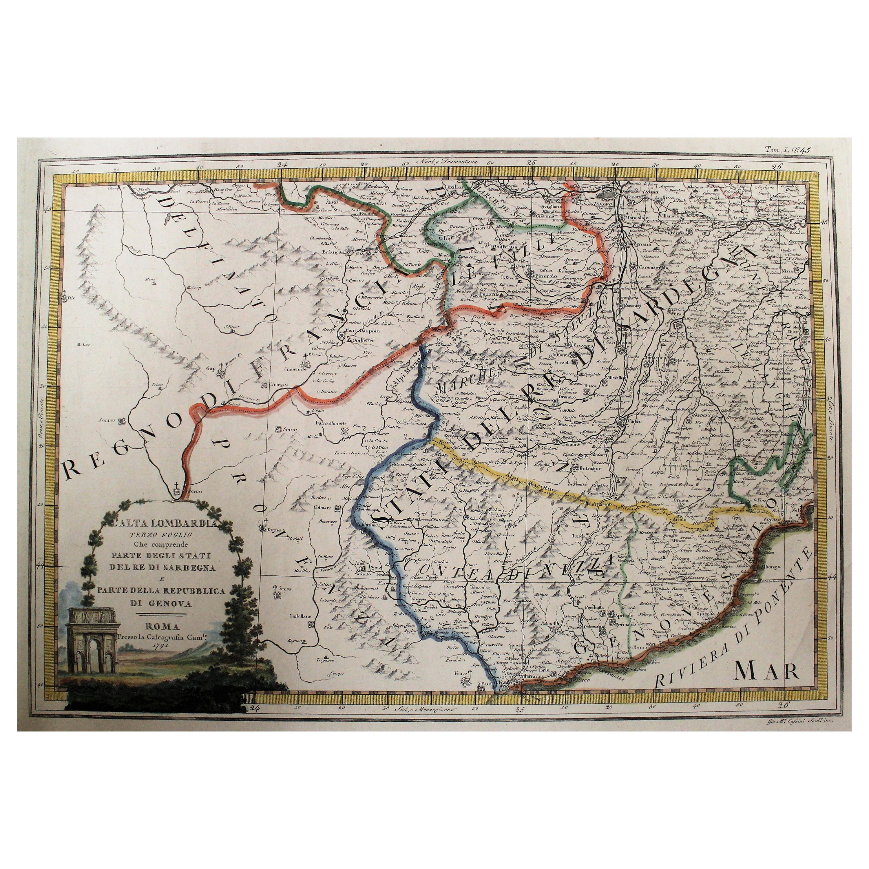
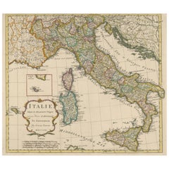
Map of the Republic of Genoa
$750
£573.41
€660.46
CA$1,050.98
A$1,173.32
CHF 614.80
MX$14,362.59
NOK 7,807.99
SEK 7,361.95
DKK 4,929.07
Shipping
Retrieving quote...The 1stDibs Promise:
Authenticity Guarantee,
Money-Back Guarantee,
24-Hour Cancellation
About the Item
Framed antique hand-coloured map of the Republic of Genoa including the duchies of Mantua, Modena, and Parma.
Europe, late 18th century.
Dimension: 25.75 " W x 22.5" H x .75" D; sight 23.25" W x 19.75" H
- Dimensions:Height: 22.5 in (57.15 cm)Width: 25.75 in (65.41 cm)Depth: 0.75 in (1.91 cm)
- Place of Origin:
- Period:
- Date of Manufacture:Unknown
- Condition:Wear consistent with age and use. Minor losses. Small loss to map at middle right, some foxing and staining.
- Seller Location:New York, NY
- Reference Number:1stDibs: LU108423093762
About the Seller
4.9
Platinum Seller
Premium sellers with a 4.7+ rating and 24-hour response times
Established in 1993
1stDibs seller since 2014
588 sales on 1stDibs
Typical response time: <1 hour
- ShippingRetrieving quote...Shipping from: New York, NY
- Return Policy
Authenticity Guarantee
In the unlikely event there’s an issue with an item’s authenticity, contact us within 1 year for a full refund. DetailsMoney-Back Guarantee
If your item is not as described, is damaged in transit, or does not arrive, contact us within 7 days for a full refund. Details24-Hour Cancellation
You have a 24-hour grace period in which to reconsider your purchase, with no questions asked.Vetted Professional Sellers
Our world-class sellers must adhere to strict standards for service and quality, maintaining the integrity of our listings.Price-Match Guarantee
If you find that a seller listed the same item for a lower price elsewhere, we’ll match it.Trusted Global Delivery
Our best-in-class carrier network provides specialized shipping options worldwide, including custom delivery.More From This Seller
View AllAntique Map of Italy by Andriveau-Goujon, 1843
By Andriveau-Goujon
Located in New York, NY
Antique Map of Italy by Andriveau-Goujon, 1843. Map of Italy in two parts by Andriveau-Goujon for the Library of Prince Carini at Palazzo Carini i...
Category
Antique 1840s French Maps
Materials
Linen, Paper

$3,350 / set
Pair Antique Italian Maps of the North American Eastern Seaboard
Located in New York, NY
Pair antique Italian maps of the North American Eastern Seaboard. Late 18th early 19th century original Italian documentation of the East Coast of the United States from Passamaquadd...
Category
Antique Late 18th Century Italian Maps
Materials
Wood, Paper

Giuseppe Casciaro, Ischia, 1929
By Giuseppe Casciaro
Located in New York, NY
Giuseppe Casciaro, Ischia, 1929. Giuseppe Casciaro (1861-1941) Amalfi coast landscape with watchtower on the island of Ischia. Pastel and gouache on card. Signed and dated 19 Feb VII...
Category
Vintage 1920s Italian Paintings
Materials
Giltwood, Paper
Villa at Napoli
Located in New York, NY
Villa at Napoli. Vintage twenties chalk on paper view of a villa near Naples or Amalfi coast with characteristic umbrella pines and vibrant skies in a period gilt frame; signed lower...
Category
Early 20th Century Italian Paintings
Materials
Paper
$3,300
Mid-century view of Piazza del Popolo
Located in New York, NY
Mid-century view of Piazza del Popolo. Large pastel and gouache on paper of the obelisk with lions and the twin churches of the famous Piazza Del Popolo in Rome. Signed lower right "...
Category
Vintage 1960s Italian Mid-Century Modern Paintings
Materials
Paper
Gilt-Framed View of Bensançon
Located in New York, NY
Gilt-framed view of Besançon. Lemon gilt framed engracing of early 19th century view of Besançon France, 19th century
Dimensions: 13.5” W x 7.5” H x...
Category
Antique 19th Century French Prints
Materials
Giltwood, Paper
You May Also Like
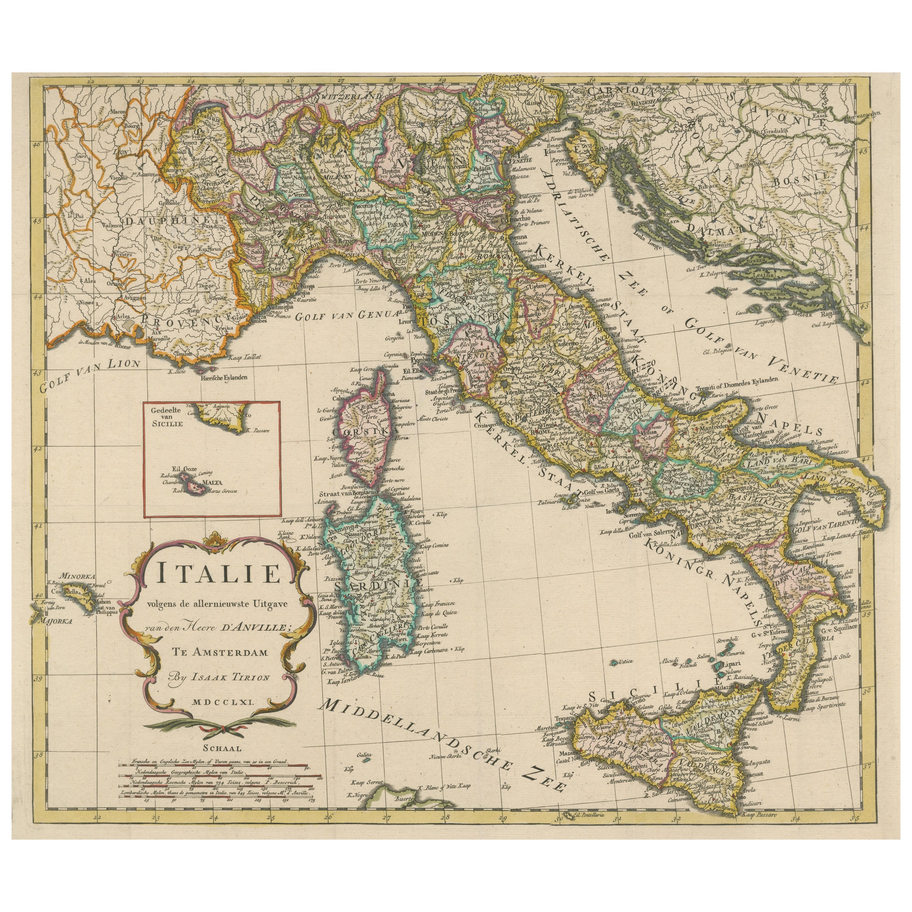
Detailed Antique Map of Italy and surrounding Islands
Located in Langweer, NL
Antique map titled 'Italie volgens de allernieuwste Uitgave van den Heere d'Anville'. Very detailed antique map, based on D'Anville's important map of It...
Category
Antique Mid-18th Century Maps
Materials
Paper
$586 Sale Price
20% Off
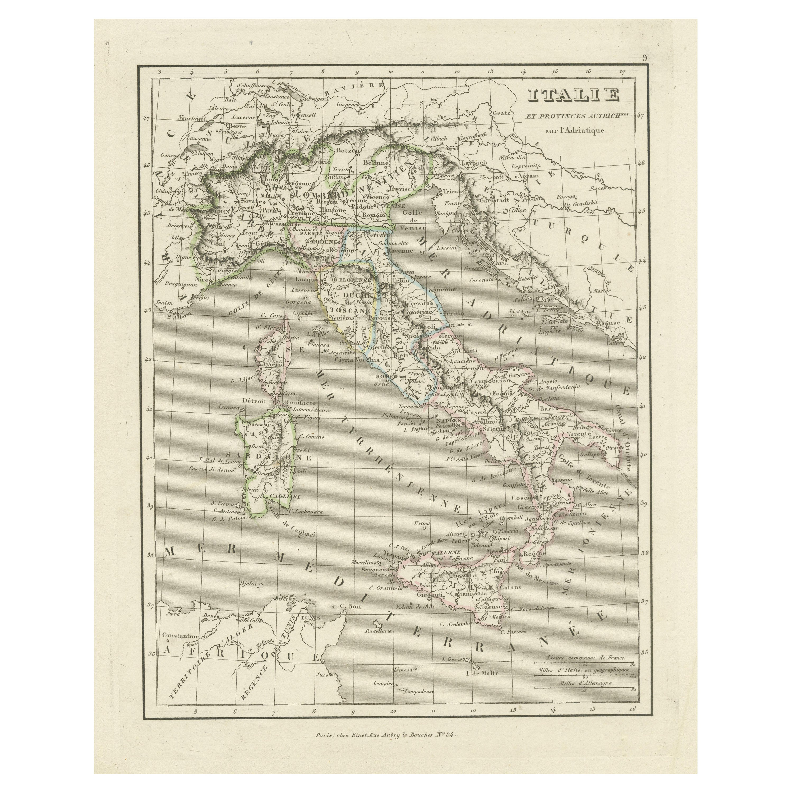
Antique Map of Italy and Other Regions Near the Adriatic Sea
Located in Langweer, NL
Antique map titled 'Italie et Provinces Autrichnes sur l'Adriatique'. Original old map of Italy and surroundings. Also shows Sicily and Sardinia. Ori...
Category
Antique Mid-19th Century Maps
Materials
Paper
$160 Sale Price
20% Off
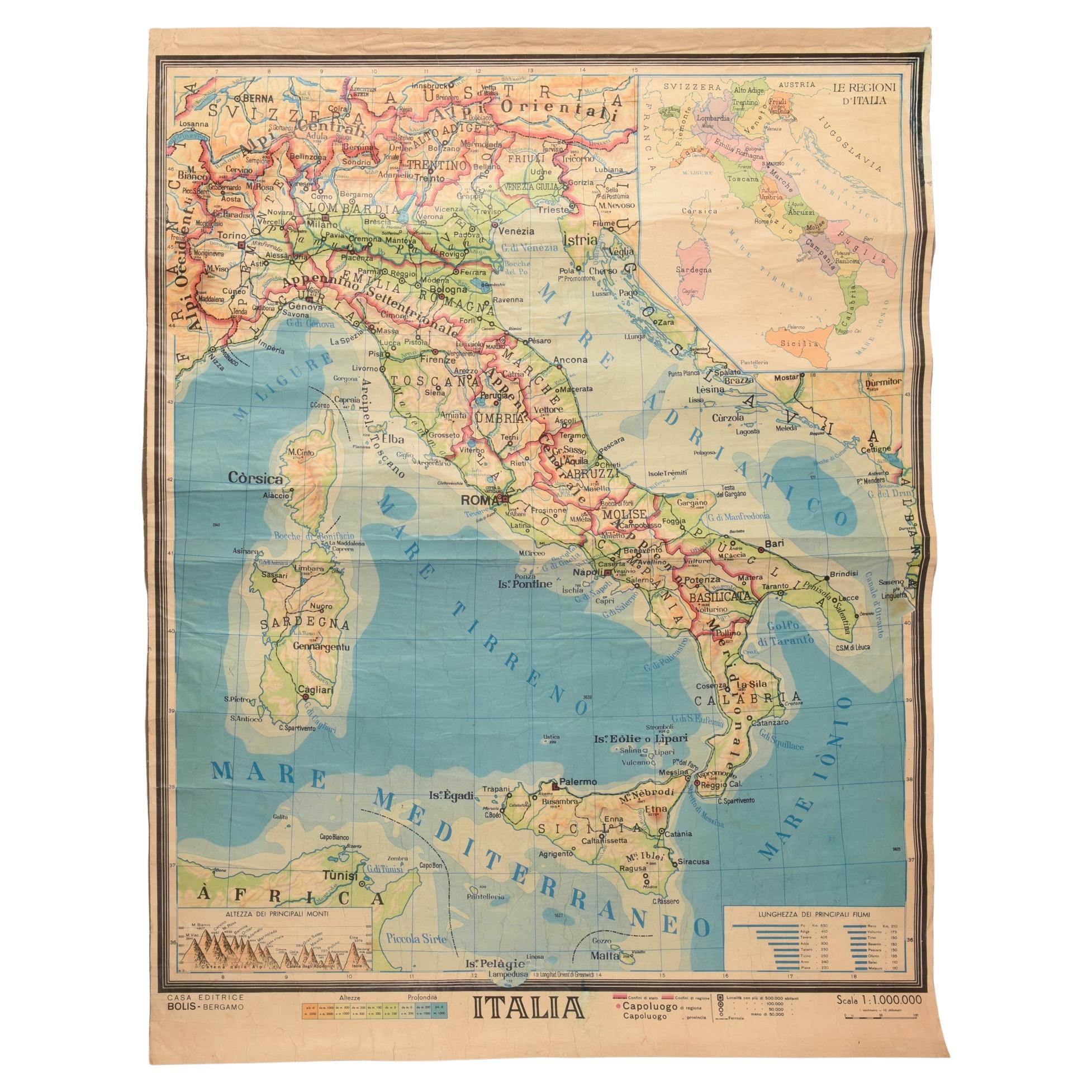
Geographical Map of Italy
Located in Alessandria, Piemonte
BOLIS Publishing House - Bergamo.
A beautiful large map of Italy, on paper but suitably reinforced to preserve it correctly. The maps were usually p...
Category
Mid-20th Century Italian Other Prints
Materials
Paper

Original Antique Map of Italy with an Inset of Sardinia, 1882
Located in Langweer, NL
Embark on a historical odyssey with an original Antique Map of Italy from the esteemed 'Comprehensive Atlas and Geography of the World,' meticulously crafted in 1882. This captivatin...
Category
Antique 1880s Maps
Materials
Paper

$198 Sale Price
20% Off
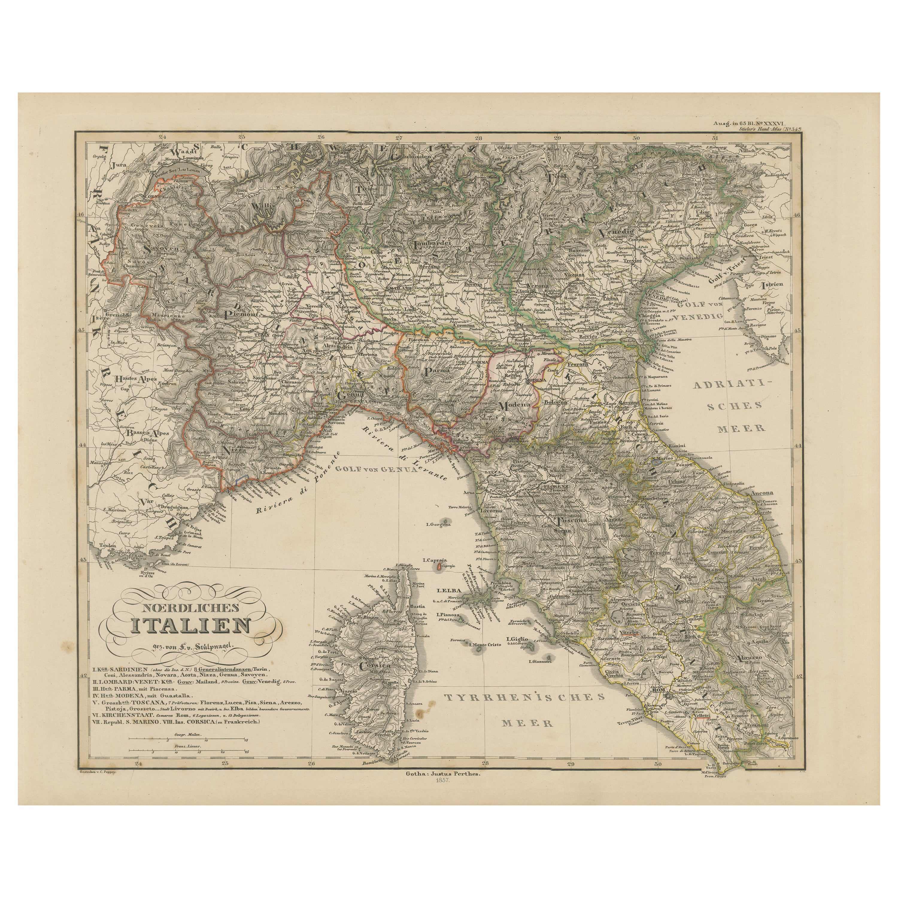
Northern Italy Map – Lombardy, Venetia, Tuscany, and Sardinia 1857
Located in Langweer, NL
Northern Italy Map – Lombardy, Venetia, Tuscany, and Sardinia 1857
This detailed antique print shows “Nördliches Italien” meaning “Northern Italy,” published in 1857 by Justus Perth...
Category
Antique Mid-19th Century German Maps
Materials
Paper

Map of the Kingdom of Sardinia and Part of the Kingdom of Genoa, Rome
By Giovanni Maria Cassini
Located in Hamilton, Ontario
18th century map by Italian engraver Giovanni Maria Cassini (Italy 1745-1824). Map of Part of the Kingdom of Sardinia and Part of the Kingdom of Genoa: Rome. This is a hand colored a...
Category
Antique 18th Century Italian Maps
Materials
Paper

$795 Sale Price
36% Off