Items Similar to Mid-18th Century Hand Drawn English Farm Map on Vellum, circa 1740s


Want more images or videos?
Request additional images or videos from the seller
1 of 10
Mid-18th Century Hand Drawn English Farm Map on Vellum, circa 1740s
$1,250
£944.85
€1,085.80
CA$1,740.62
A$1,936.37
CHF 1,015.07
MX$23,661.91
NOK 12,925.61
SEK 12,167.68
DKK 8,105.05
Shipping
Retrieving quote...The 1stDibs Promise:
Authenticity Guarantee,
Money-Back Guarantee,
24-Hour Cancellation
About the Item
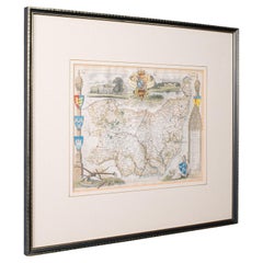
Mid-18th century hand drawn English farm map on Vellum circa 1740s
Henry Maxted & Isaac Terry, Surveyors.
A Map of a Farm in the Parish of Blean in the County of KENT: Belonging to Mrs Elizabeth Hodgson circa 1743.
A beautiful hand drawn map of a private farm in England. The directional on the map is balanced by a Fleur-de-lis.
Dimensions 20.5" x 11". The frame measures 25" x 16".
The back of the frame has a window opening with more text (see pics).
Very good antique condition.
This is truly a wonderful find and will look great hanging in any home library, or office.
No detail was overlooked in the lay of the farm, and the lovely wildflower floral wreath in the center of map adds a colorful touch.
- Dimensions:Height: 16 in (40.64 cm)Width: 25 in (63.5 cm)Depth: 3 in (7.62 cm)
- Materials and Techniques:Lambskin,Hand-Painted
- Place of Origin:
- Period:Mid-18th Century
- Date of Manufacture:circa 1740
- Condition:Wear consistent with age and use.
- Seller Location:San Francisco, CA
- Reference Number:1stDibs: LU5199219585122
About the Seller
5.0
Gold Seller
Premium sellers maintaining a 4.3+ rating and 24-hour response times
Established in 1985
1stDibs seller since 2020
386 sales on 1stDibs
Typical response time: 2 hours
- ShippingRetrieving quote...Shipping from: San Francisco, CA
- Return Policy
Authenticity Guarantee
In the unlikely event there’s an issue with an item’s authenticity, contact us within 1 year for a full refund. DetailsMoney-Back Guarantee
If your item is not as described, is damaged in transit, or does not arrive, contact us within 7 days for a full refund. Details24-Hour Cancellation
You have a 24-hour grace period in which to reconsider your purchase, with no questions asked.Vetted Professional Sellers
Our world-class sellers must adhere to strict standards for service and quality, maintaining the integrity of our listings.Price-Match Guarantee
If you find that a seller listed the same item for a lower price elsewhere, we’ll match it.Trusted Global Delivery
Our best-in-class carrier network provides specialized shipping options worldwide, including custom delivery.More From This Seller
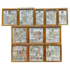
View AllA Variety of Eleven Wonderful Old Maps, Framed
Located in San Francisco, CA
A Variety of Eleven Wonderful Old Maps, Framed
Category
20th Century Decorative Art
Materials
Paper
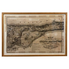
1868 Map of the Upper Part of the Island of Manhattan Above 86th Street
By Wm. Rogers Mfg. Co.
Located in San Francisco, CA
This wonderful piece of New York City history is over 150 years old. It depicts 86th street and above. It was lithographed by WC Rogers and company. It was made to show what was the Battle of Harlem during the Revolutionary war...
Category
Antique 1860s American American Colonial Maps
Materials
Paper
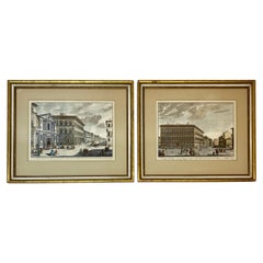
19th Century Pair of Framed Italian Hand Colored Engravings
Located in San Francisco, CA
19th century pair of framed Italian hand colored engravings
One engraving depicts a scene from Florence, Italy
The other depicts a sc...
Category
Antique Late 19th Century Italian Prints
Materials
Paper
Jean Claude Werdier Vintage Normandy Village Landscape, circa 1970s
Located in San Francisco, CA
Jean Claude Werdier (French painter Jean Claude Werdier was born in 1922. He later moved to the U.S. where he painted surrealist landscapes.) created this fine vintage Normandy villa...
Category
Mid-20th Century French Mid-Century Modern Paintings
Materials
Canvas

Late 18th-Early 19th C. Venetian Tapestry
Located in San Francisco, CA
Late 18th- early 19th century framed silk embroidered tapestry in a stunning blend of intricate design and rich colors that will enhance any de...
Category
Antique Late 18th Century European Renaissance Tapestries
Materials
Silk

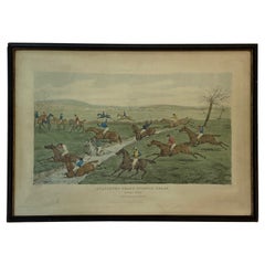
Mid 19th Century "Aylesbury Grand Steeple Chase, Brook Scene" Color Engraving
Located in San Francisco, CA
Mid 19th century "Aylesbury Grand Steeple Chase, Brook Scene" color engraving
Fine old engraving with aquatint published by S&J Fuller in 1866
Measures: 20" wide x 14.5" high
...
Category
Antique Mid-19th Century English Prints
Materials
Paper
You May Also Like
Antique Map of Essex by Overton, circa 1710
Located in Langweer, NL
Antique map titled 'Essex, devided into Hundreds, with the most antient and fayre Towne Colchester (..)'. Map of Essex, England. Includes an inset town pl...
Category
Antique Early 18th Century Maps
Materials
Paper

$910 Sale Price
20% Off
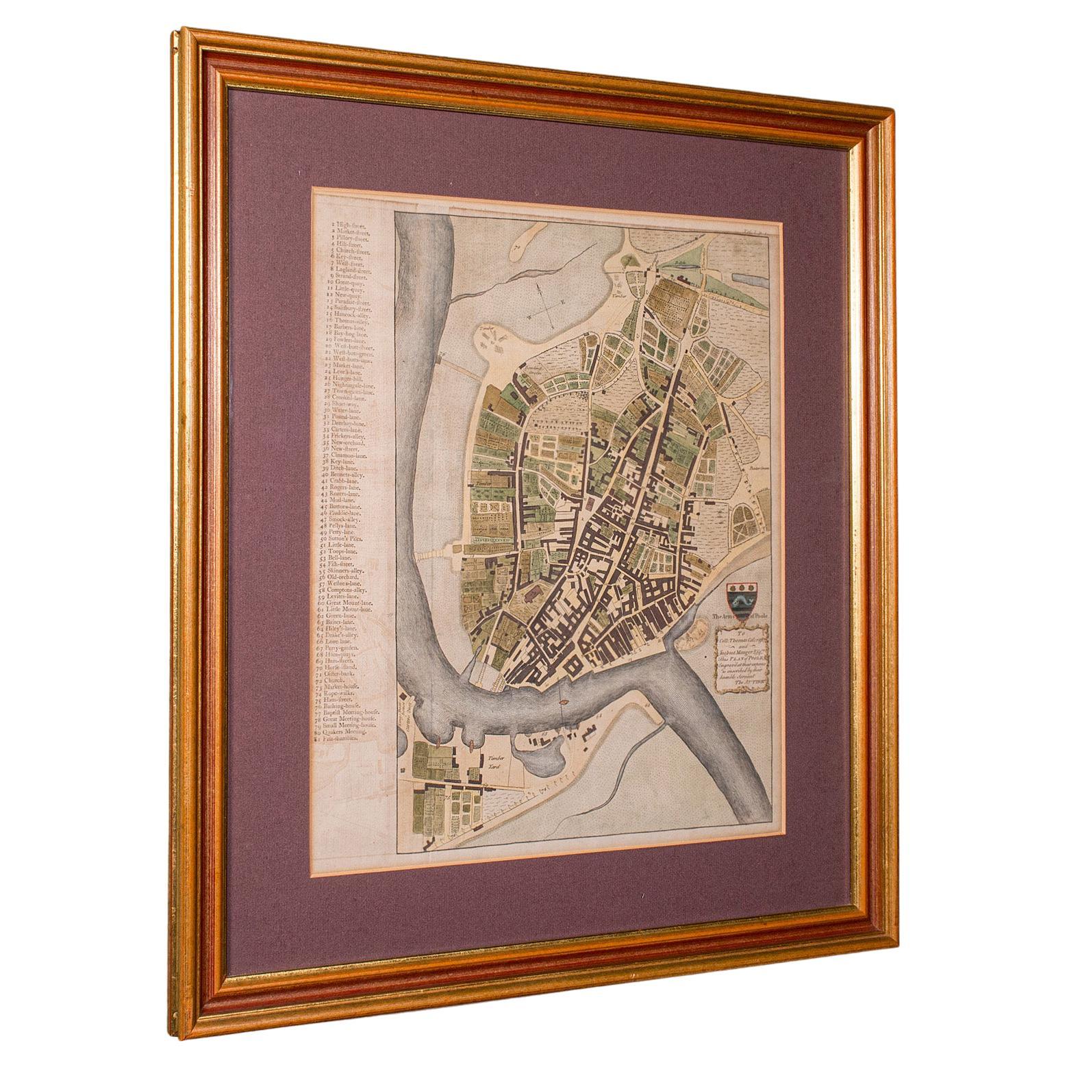
Antique Town Plan Map, Poole, English, Framed Cartography, Georgian, Circa 1780
Located in Hele, Devon, GB
This is an antique town plan map of Poole in Dorset. An English, framed atlas engraving, dating to the 18th century and later.
Fascinating cartography with annotated streets and pl...
Category
Antique Late 18th Century British George III Maps
Materials
Glass, Wood, Paper

Rare 18th C. Newport Map
Located in Sandwich, MA
Rare 18th C, Map titled "A plan of the town of Newport in the province of Rhode Island". Earliest printed plan of Newport, published for the use of the British just prior to their o...
Category
Antique 1770s American Maps
Materials
Paper

$19,500 / item
Framed 17th Century Map of Cumberland, England by John Speed, 1610
By John Speed
Located in Middleburg, VA
A fascinating and richly detailed antique map of Cumberland County in northwest England, drawn and published by the celebrated English cartographer John Spe...
Category
Antique Early 17th Century English British Colonial Maps
Materials
Copper, Gold Leaf

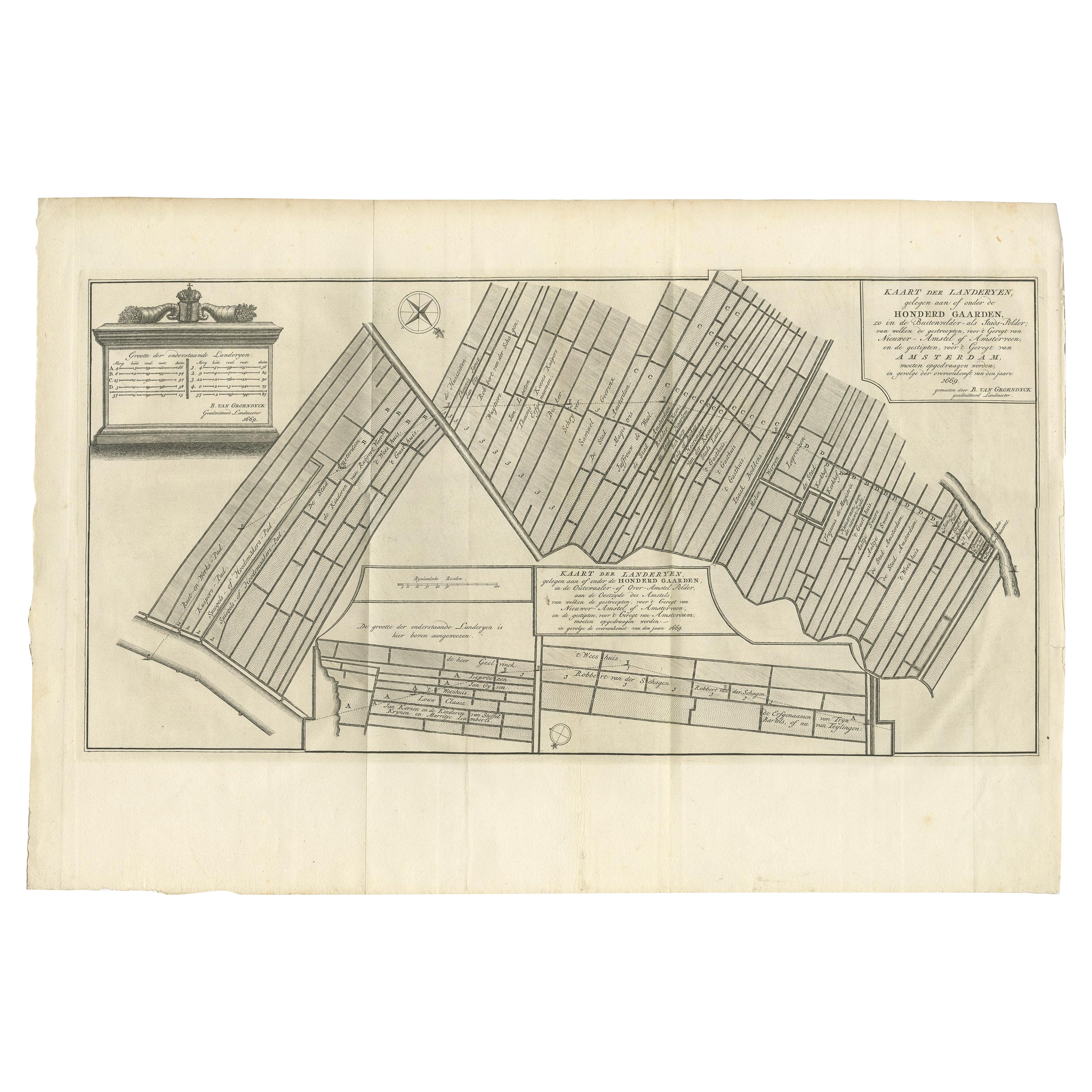
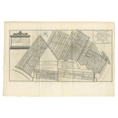
Antique Map Showing Estates of 1669 in Amsterdam, Published in c.1767
Located in Langweer, NL
Antique map titled 'Kaart der landeryen, gelegen aan of onder de honderd gaarden, zo in de Buitenvelder- als Stads-polder; van welken de gestreepten, voor 't geregt van Nieuwer-Amste...
Category
Antique 18th Century Maps
Materials
Paper
$239 Sale Price
20% Off
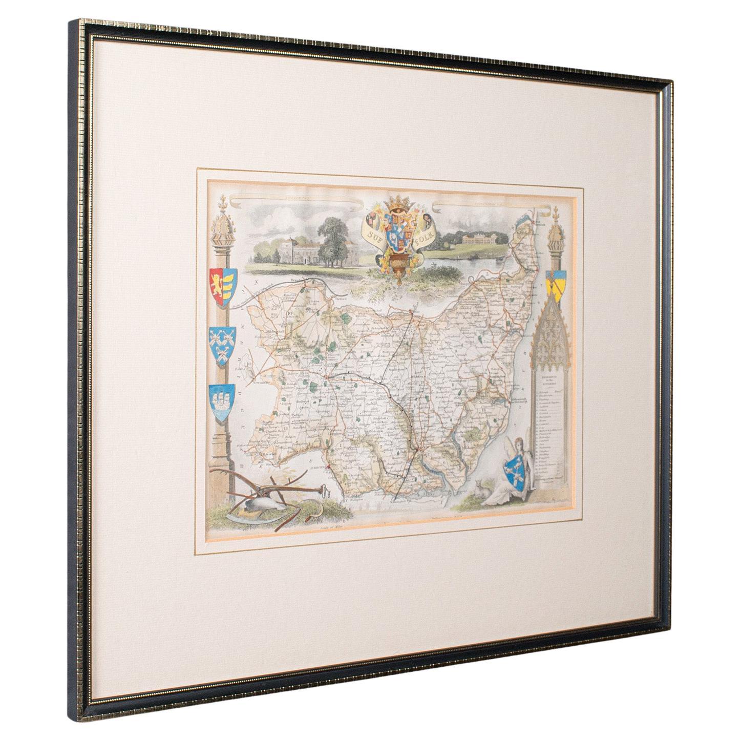
Antique County Map, Suffolk, English, Framed Lithograph, Cartography, Victorian
Located in Hele, Devon, GB
This is an antique lithography map of Suffolk. An English, framed atlas engraving of cartographic interest, dating to the mid 19th century and later.
Superb lithography of Suffolk ...
Category
Antique Mid-19th Century British High Victorian Maps
Materials
Paper
More Ways To Browse
Antique 18th Century English Frames
Hand Drawn Map
Antique Surveyor
Antique Farm Antiques Collectibles
Hand Painted Antique Map
Indonesia Map
Antique Framed Map Engravings
Atlas Furniture Company
Used Office Furniture Edinburgh
Antique 16th Century Plates
Scotland Map
Antique Maps Indonesia
Map Of Japan
Antique Rollers
Compass Rose Antique
Dutch Empire
Swiss Antiques And Collectables
Antique Compass Map