Items Similar to Navigational Chart of Jamaica, Cape Gracias a Dios, and the Mosquito Coast, 1775

Want more images or videos?
Request additional images or videos from the seller
1 of 10
Navigational Chart of Jamaica, Cape Gracias a Dios, and the Mosquito Coast, 1775
$1,006.44
$1,437.7730% Off
£749.23
£1,070.3330% Off
€840
€1,20030% Off
CA$1,378.57
CA$1,969.3930% Off
A$1,533.27
A$2,190.3930% Off
CHF 800.63
CHF 1,143.7530% Off
MX$18,658.30
MX$26,654.7230% Off
NOK 10,225.24
NOK 14,607.4830% Off
SEK 9,589.47
SEK 13,699.2430% Off
DKK 6,394.63
DKK 9,135.1830% Off
Shipping
Retrieving quote...The 1stDibs Promise:
Authenticity Guarantee,
Money-Back Guarantee,
24-Hour Cancellation
About the Item
The map titled "The Island of Jamaica and Cape Gracias a Dios with the Banks (Shows Moskito Kings Party)" illustrates a significant historical period marked by shifting colonial influences and territorial disputes in Central America and the Caribbean. Here's a detailed description:
Key Features of the Map:
1. **Geographical Coverage**:
- The map highlights the Island of Jamaica and Cape Gracias a Dios, including the surrounding banks and coastal regions.
- It prominently features the Mosquito Coast, an area along the eastern coast of present-day Nicaragua and Honduras.
2. **Political Context**:
- During the time this map represents, Spanish power over the Mosquito Coast had diminished, and British influence was resurging.
- The Captaincy General of Guatemala aimed to assert control over the Mosquito Coast but faced challenges.
3. **Significant Historical Events**:
- In 1803, the Spanish government, influenced by the advice of Gil de Taboada and Ezpeleta, decided against Guatemala's request to control the Mosquito Coast.
- Instead, sovereignty over the Mosquito Coast was transferred to the Viceroyalty of New Granada (modern-day Colombia) by a Royal Decree on November 30, 1803.
- This decision reaffirmed the control of New Granada over the Archipelago of San Andrés, Providencia, and Santa Catalina, which were used as bases against British privateers operating from the Mosquito Coast.
4. **Impact of the Royal Decree of 1803**:
- The decree led to ongoing territorial disputes between the United Provinces of Central America (later Nicaragua) and Gran Colombia (later Colombia) throughout the 19th century.
- Spanish rule was never fully restored over the Mosquito Coast, and in 1806, the British occupied the Archipelago of San Andrés, Providencia, and Santa Catalina during their war against Spain.
5. **Historical Interpretation**:
- Ricardo S. Pereira, writing in 1883, considered the Real Audiencia of Guatemala's failure to raise an army and march on the Mosquito Coast a significant miscalculation. He believed that such a move would have solidified the Captaincy General's control over the area once Spanish power was restored.
Conclusion:
The map serves as a visual representation of a period of intense colonial competition and territorial realignment in the Caribbean and Central America. It underscores the complexities of colonial administration, the strategic importance of the Mosquito Coast and nearby archipelagos, and the long-term implications of colonial decisions on regional disputes in the post-independence era.
About the Maker: :
The map's title indicates that it was created by a geographer to His Majesty, suggesting it was an official document commissioned by the British crown or government.
The title reads: "The Island of Jamaica and Cape Gracias a Dios with the Banks by the Messrs. Geographer to His Majesty," indicating that it was produced by a respected cartographer or a team of cartographers with official status.
Publication Details:
The map includes a note at the bottom stating it was published in London, suggesting that it was intended for use by British navigators and officials.
The exact wording from the bottom states: "London Printed for R. Sayer & J. Bennett, Map, Chart & Print sellers, No. 53 Fleet Street, as the Act directs, 1st August 1775." This provides the publication date and the names of the publishers, Richard Sayer and John Bennett, who were prominent map and print sellers in London during the 18th century.
Conclusion:
This map is a detailed navigational chart from the 18th century, providing valuable information about the geography and political landscape of Jamaica, Cape Gracias a Dios, and the surrounding banks. It was created by official geographers for the British monarchy and published in London by well-known map sellers, reflecting its importance for maritime navigation and colonial administration during that era.
- Dimensions:Height: 20.87 in (53 cm)Width: 27.96 in (71 cm)Depth: 0.01 in (0.2 mm)
- Materials and Techniques:Paper,Engraved
- Period:1770-1779
- Date of Manufacture:1775
- Condition:Repaired: repairs of the folding line on the reverse with tape. Good condition, given age. Fold as published. General age-related creasing and toning and/or occasional minor defects from handling. One tiny pinhole in top left corner. Please study image carefully.
- Seller Location:Langweer, NL
- Reference Number:Seller: BG-13744-51stDibs: LU3054340350832
About the Seller
5.0
Recognized Seller
These prestigious sellers are industry leaders and represent the highest echelon for item quality and design.
Platinum Seller
Premium sellers with a 4.7+ rating and 24-hour response times
Established in 2009
1stDibs seller since 2017
2,510 sales on 1stDibs
Typical response time: <1 hour
- ShippingRetrieving quote...Shipping from: Langweer, Netherlands
- Return Policy
Authenticity Guarantee
In the unlikely event there’s an issue with an item’s authenticity, contact us within 1 year for a full refund. DetailsMoney-Back Guarantee
If your item is not as described, is damaged in transit, or does not arrive, contact us within 7 days for a full refund. Details24-Hour Cancellation
You have a 24-hour grace period in which to reconsider your purchase, with no questions asked.Vetted Professional Sellers
Our world-class sellers must adhere to strict standards for service and quality, maintaining the integrity of our listings.Price-Match Guarantee
If you find that a seller listed the same item for a lower price elsewhere, we’ll match it.Trusted Global Delivery
Our best-in-class carrier network provides specialized shipping options worldwide, including custom delivery.More From This Seller
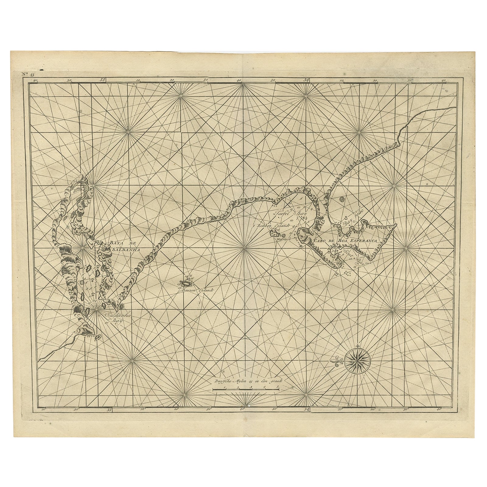
View AllSea Chart Titled 'Baya de Saldanha' with Robben Island in South Africa, 1726
Located in Langweer, NL
Antique map titled 'Baya de Saldanha'.
Sea chart covering the South African coast from the Cape of Good Hope to Saldanha Bay. This print originates from 'Oud en Nieuw Oost-Indiën...
Category
Antique 1720s Maps
Materials
Paper
$1,073 Sale Price
20% Off
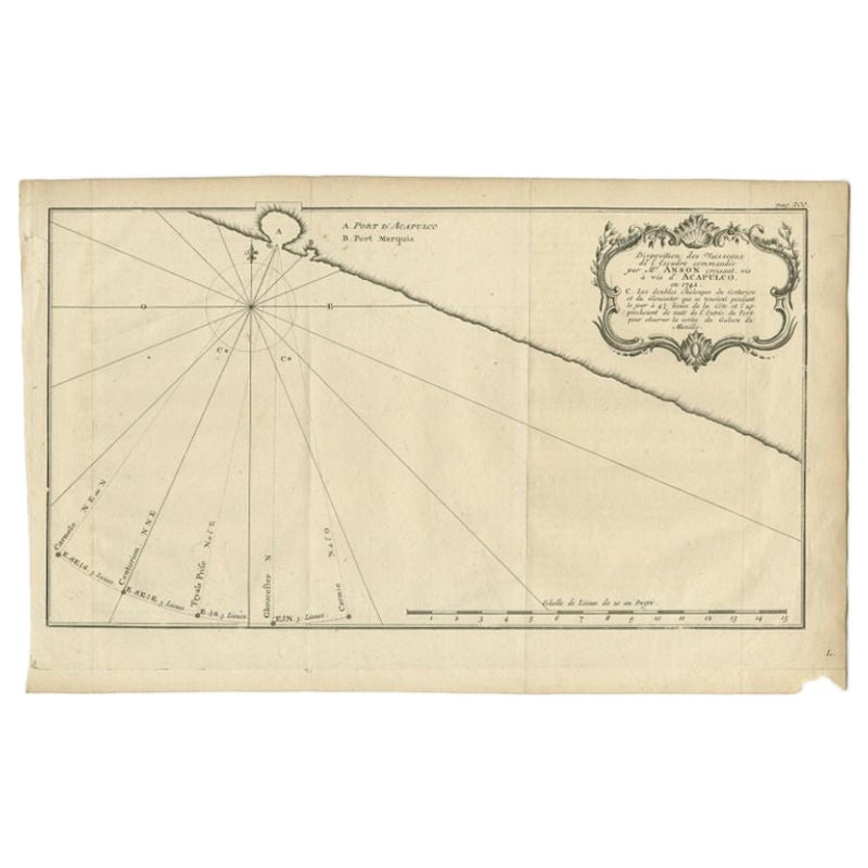
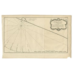
Antique Map of the Coast of Acapulco by Anson, c.1740
Located in Langweer, NL
Antique map titled 'Disposition des Vaisseaux de l'Escadre commandée par Mr. Anson croisant vis à vis d'Acapulco en 1742'. This map depicts the coast of Acapulco in Mexico with a decorative cartouche and windrose. Acapulco and its port were important to the Mission of Commodore George Anson, who captured a Spanish treasure...
Category
Antique 18th Century Maps
Materials
Paper
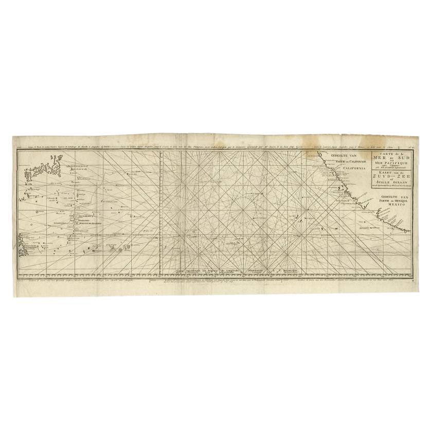
Antique Map of the Pacific Ocean by Anson, 1765
Located in Langweer, NL
Antique map titled 'Carte de la Mer du Sud ou Mer Pacifique - Kaart van de Zuyd-Zee of stille oceaan (..)'. Nautical chart of the Pacific Ocean depicting the trade routes used by Spanish Galleons from Acapulco in Mexico to Manila in the Philippines. In particular this chart depicts the voyages of the Spanish Nostra Seigniora de Cabadonga and the British Navy Commodore George Anson. Anson succeed in capturing the Spanish treasure...
Category
Antique 18th Century Maps
Materials
Paper

$944 Sale Price
20% Off
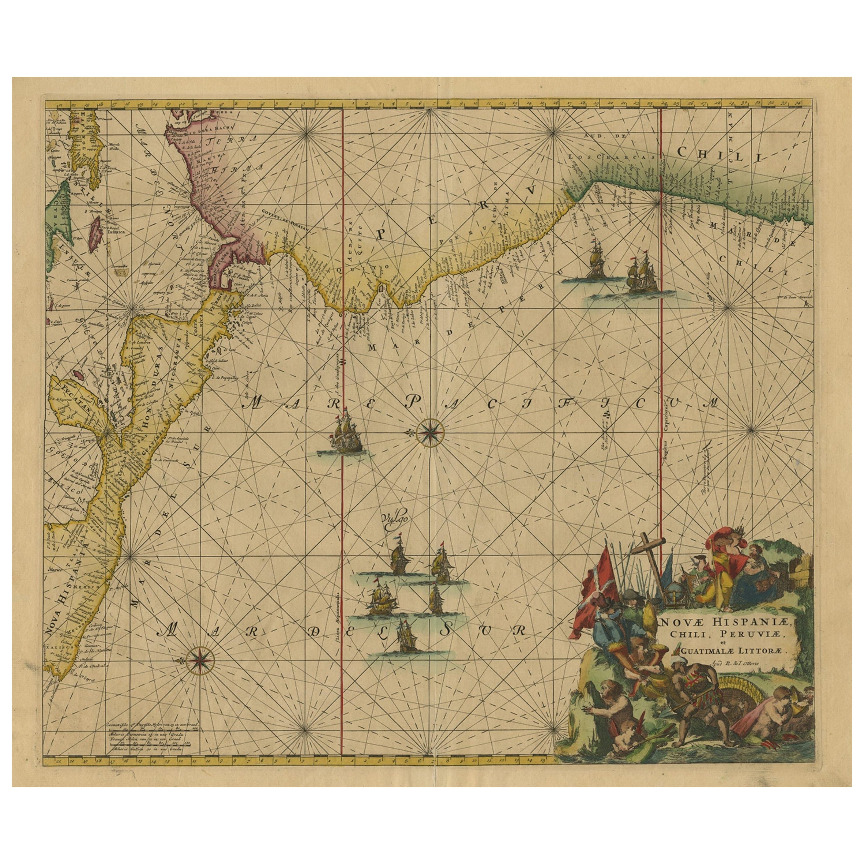
Sea Chart of Central America and the Northwest Coast of South America, ca.1745
Located in Langweer, NL
Antique map titled 'Novae Hispaniae, Chili, Peruviae et Guatamala Littorae.'
Sea chart of Central America and the northwest coast of South America, oriented to the east, by Reinier & Joshua Ottens (after Frederick de Wit - 1675) in 1745 ('Atlas van de Zeevaart'). The map shows all or parts of the coasts of Peru, Chili, Honduras, Costa Rica and Mexico as well as the western Caribbean and the Galapagos...
Category
Antique 1740s Maps
Materials
Paper
$2,348 Sale Price
20% Off
Free Shipping
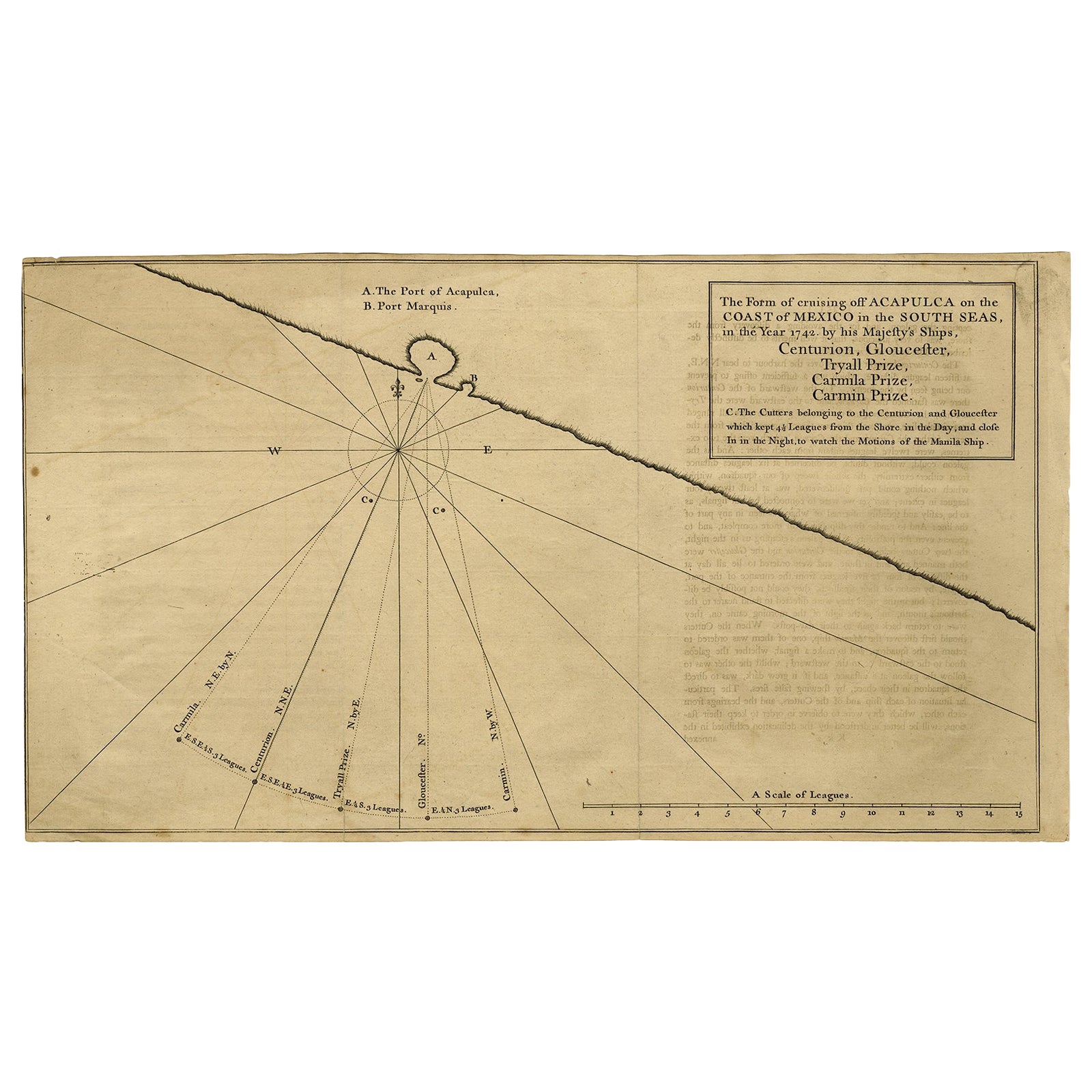
Navigational Chart of Mexico's Coast, with Acapulco and Port Marquis, 1748
Located in Langweer, NL
Antique map titled 'The Form of cruising off Acapulca on the Coast of Mexico in the South Seas in the Year 1742. by His Majesty's Ships, Centurion, Gloucester, Tryall Prize, Carmila ...
Category
Antique 1740s Maps
Materials
Paper

$134 Sale Price
20% Off
Sea Chart of Part of the Southwestern Coast of Sumatra & Nias, Indonesia, C1775
Located in Langweer, NL
Antique map titled 'Carte de la Côte Occidentale de l'Isle Sumatra'. Sea chart of the part of the south-western coast of Sumatra with the Nassau (Nias) and Fortune isles.
Artists ...
Category
Antique 1770s Maps
Materials
Paper

$485 Sale Price
25% Off
You May Also Like
West Coast of Africa, Guinea & Sierra Leone: An 18th Century Map by Bellin
By Jacques-Nicolas Bellin
Located in Alamo, CA
Jacques Bellin's copper-plate map entitled "Partie de la Coste de Guinee Dupuis la Riviere de Sierra Leona Jusquau Cap das Palmas", depicting the coast of Guinea and Sierra Leone in ...
Category
Antique Mid-18th Century French Maps
Materials
Paper

Original Antique Map of South America. C.1780
Located in St Annes, Lancashire
Great map of South America
Copper-plate engraving
Published C.1780
Two small worm holes to left side of map
Unframed.
Category
Antique Early 1800s English Georgian Maps
Materials
Paper

California, Alaska and Mexico: 18th Century Hand-Colored Map by de Vaugondy
By Didier Robert de Vaugondy
Located in Alamo, CA
This is an 18th century hand-colored map of the western portions of North America entitled "Carte de la Californie et des Pays Nord-Ouest separés de l'Asie par le détroit d'Anian, ex...
Category
Antique 1770s French Maps
Materials
Paper

St. Christophe 'St. Kitts' Island: An 18th Century Hand-colored Map by Bellin
By Jacques-Nicolas Bellin
Located in Alamo, CA
Jacques Bellin's copper-plate map of the Caribbean island of Saint Kitts entitled "Carte De De l'Isle St. Christophe Pour servir á l'Histoire Genle. des V...
Category
Antique Mid-18th Century French Maps
Materials
Paper

1627 Hendrik Hondius Map Entitled "Vltoniae Orientalis Pars, " Ric.a009
Located in Norton, MA
1627 Hendrik Hondius map entitled
"Vltoniae orientalis pars,"
Ric.a009
Title:
Vltoniae orientalis : pars
Title (alt.) :
Ultoniae orientalis pars
Creator:
Mercator, Gerh...
Category
Antique 17th Century Dutch Maps
Materials
Paper

Dartmouth, England: A Hand-Colored 17th Century Sea Chart by Captain Collins
By Captain Greenvile Collins
Located in Alamo, CA
This hand-colored sea chart of the area around Dartmouth, England is from "Great Britain's Coasting Pilot. Being a New and Exact Survey of the Sea-Coast of England", first published ...
Category
Antique Late 17th Century English Maps
Materials
Paper

More Ways To Browse
Cape Antique Furniture
Used Furniture Jamaica
Maritime Antiques
Antique Oushak Carpets
Blue Coffee Tables
1945 Chair Juhl
Antique Three Leg Table
Folke Arstrom
Silver Over Copper
Vintage Barware Glasses
Antique Etched Glass
Antique French Shell
Coffee Table Black Italian Modern
Christofle America
Iranian Silk Rug Carpet
Poul Moller
Tables With Inlaid Wood
World War Table