Items Similar to Old Print with a View of the Cape of Good Hope and Table Bay, South Africa, 1750


Want more images or videos?
Request additional images or videos from the seller
1 of 8
Old Print with a View of the Cape of Good Hope and Table Bay, South Africa, 1750
$182.55
$228.1920% Off
£134.45
£168.0620% Off
€152
€19020% Off
CA$248.34
CA$310.4320% Off
A$275.97
A$344.9620% Off
CHF 144.61
CHF 180.7620% Off
MX$3,384.23
MX$4,230.2920% Off
NOK 1,844.40
NOK 2,305.5120% Off
SEK 1,735.15
SEK 2,168.9420% Off
DKK 1,157.15
DKK 1,446.4420% Off
Shipping
Retrieving quote...The 1stDibs Promise:
Authenticity Guarantee,
Money-Back Guarantee,
24-Hour Cancellation
About the Item
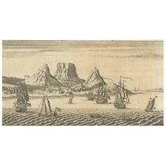
Antique print titled 'Gezigt van de Kaap de Goede-Hoop'.
Old print with a view of the Cape of Good Hope and Table Bay. Engraved by J. van Schley for a Dutch edition of 'l'Histoire Generale des Voyages', by Antoine François Prévost (the Abbé Prévost).
Artists and Engravers: Jakob van der Schley (Amsterdam 1715-1779) was a Dutch draughtsman and engraver. He studied under Bernard Picart and became heavily influenced by his style.
- Dimensions:Height: 9.93 in (25.2 cm)Width: 7.17 in (18.2 cm)Depth: 0 in (0.02 mm)
- Materials and Techniques:
- Period:1750-1759
- Date of Manufacture:circa 1750
- Condition:Condition: Very good, general age-related toning. Please study image carefully.
- Seller Location:Langweer, NL
- Reference Number:Seller: CD-12291 1stDibs: LU3054327350352
About the Seller
5.0
Recognized Seller
These prestigious sellers are industry leaders and represent the highest echelon for item quality and design.
Platinum Seller
Premium sellers with a 4.7+ rating and 24-hour response times
Established in 2009
1stDibs seller since 2017
2,494 sales on 1stDibs
Typical response time: 1 hour
- ShippingRetrieving quote...Shipping from: Langweer, Netherlands
- Return Policy
Authenticity Guarantee
In the unlikely event there’s an issue with an item’s authenticity, contact us within 1 year for a full refund. DetailsMoney-Back Guarantee
If your item is not as described, is damaged in transit, or does not arrive, contact us within 7 days for a full refund. Details24-Hour Cancellation
You have a 24-hour grace period in which to reconsider your purchase, with no questions asked.Vetted Professional Sellers
Our world-class sellers must adhere to strict standards for service and quality, maintaining the integrity of our listings.Price-Match Guarantee
If you find that a seller listed the same item for a lower price elsewhere, we’ll match it.Trusted Global Delivery
Our best-in-class carrier network provides specialized shipping options worldwide, including custom delivery.More From This Seller
View AllOld Engraving of Cape Good Hope in South Africa, 1754
Located in Langweer, NL
The text in the image reads: "The Cape of Good Hope" and "London Mag: 1754." This suggests that this small image is a rare copper engraving that was featured in the London Magazine i...
Category
Antique 1750s Prints
Materials
Paper
$124 Sale Price
20% Off
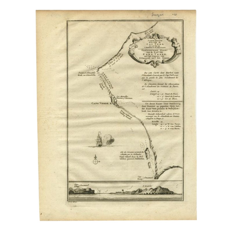
Antique Map of the Coast of Cape Verde by J. Van Der Schley, circa 1750
Located in Langweer, NL
An early map of what is now the coast of the capital city of Dakar, Senegal. What is now a dense, bustling city was at this time a uninhabited coast. Shows the overall contours of th...
Category
Antique Mid-18th Century Maps
Materials
Paper

$153 Sale Price
20% Off
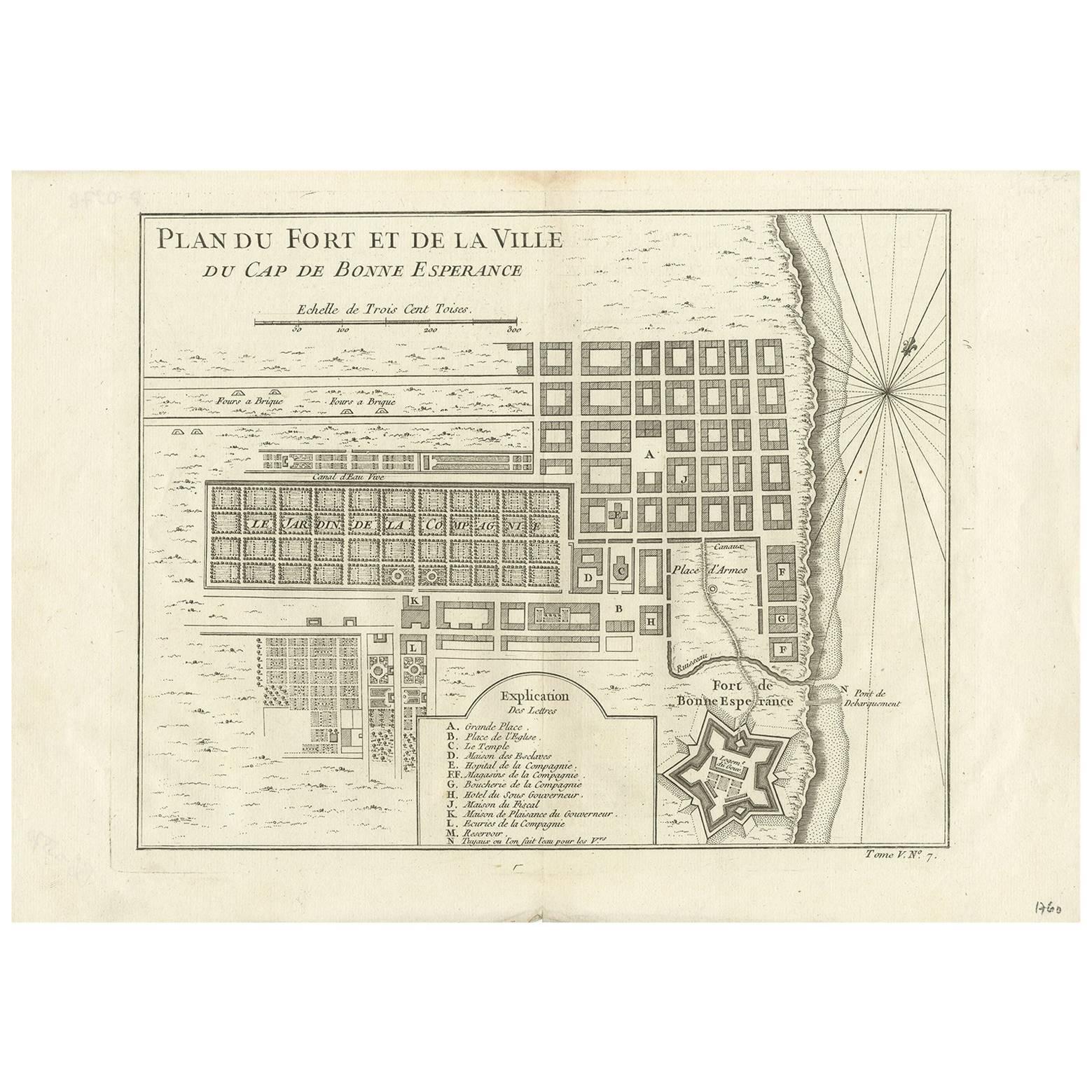
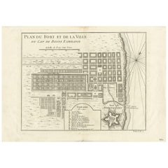
Antique Map of the Cape of Good Hope by J.N. Bellin, 1748
Located in Langweer, NL
Early plan of the Cape of Good Hope, includng a town plan and illustrations of the fortificatons. This map originates from Tome V of Abbe Prevost's Histoire generale du voyages.
Category
Antique Mid-18th Century Maps
Materials
Paper
$331 Sale Price
20% Off
The Cape Verde Islands Coast Antique Engraving by Van Schley, 1747
Located in Langweer, NL
Antique map titled ‘Carte Exacte de la cote du Cap Verd (..) - Naauwkeurige Kaart van de Kust van Kabo Verde (..)'. Original antique map of the coast of the Cape Verde Islands. This ...
Category
Antique 18th Century Maps
Materials
Paper
$100 Sale Price
20% Off
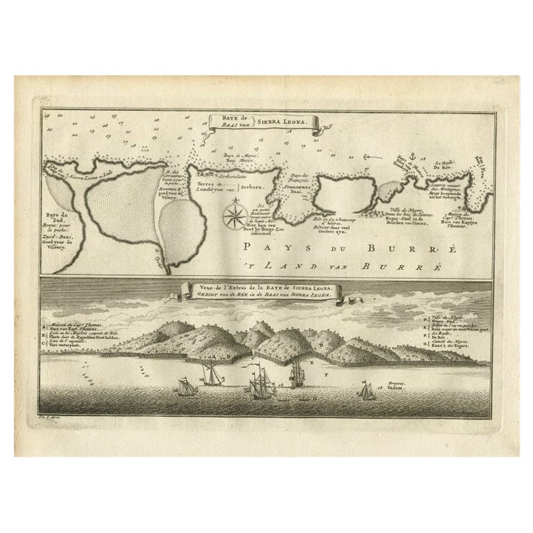
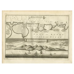
Antique Map and View of the Bay of Sierra Leone in Africa, C.1750
Located in Langweer, NL
Antique print titled 'Baye de Sierra Leona (..) - Baai van Sierra Leona (..)'. Map and view of the bay of Sierra Leone. This print originates from 'Historische beschryving der Reizen...
Category
Antique 18th Century Prints
Materials
Paper
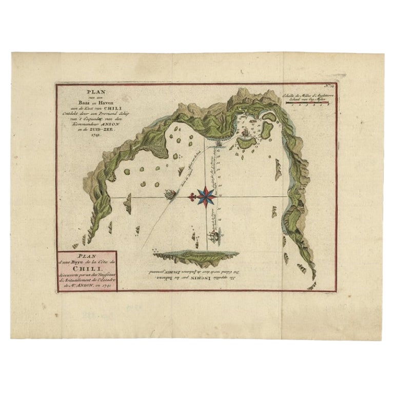
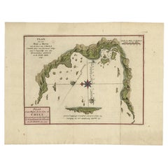
Chile Coast Bay Map – Antique 1749 Chart by Anson from Voyage Around the World
Located in Langweer, NL
Antique map titled 'Plan van een Baai en Haven aan de Kust van Chili (..) - Plan d'une Baye de la Côte du Chili (..)'. Original antique map of a bay on the coast of Chile discovered ...
Category
Antique 18th Century Maps
Materials
Paper
You May Also Like
Original Antique Map of South Africa, Arrowsmith, 1820
Located in St Annes, Lancashire
Great map of South Africa.
Drawn under the direction of Arrowsmith.
Copper-plate engraving.
Published by Longman, Hurst, Rees, Orme and Br...
Category
Antique 1820s English Maps
Materials
Paper

Very Large Hand-Drawn View of St Iago Cape Verde, by Frederici, 1783
Located in Amsterdam, NL
Johann Christian Friderici [= Frederici] (Heldburg 1766 - Cape Town 1804)
Prospect van het eyland, en de rheede van St. Iago. Geteekend van Johann Christian Friderici / Verbeelding van de inwoonders op St Iago
(View of the island, and the roadstead of St. Iago. Drawn by Johann Christian Friderci / Depiction of the inhabitants on St Iago)
?Porto Praia, Cape Verde...
Category
Antique Late 18th Century Cape Verdean Dutch Colonial Maps
Materials
Paper

West Coast of Africa, Guinea & Sierra Leone: An 18th Century Map by Bellin
By Jacques-Nicolas Bellin
Located in Alamo, CA
Jacques Bellin's copper-plate map entitled "Partie de la Coste de Guinee Dupuis la Riviere de Sierra Leona Jusquau Cap das Palmas", depicting the coast of Guinea and Sierra Leone in ...
Category
Antique Mid-18th Century French Maps
Materials
Paper

Map of Nubia and Abissinia - Original Etching by Antonio Zatta - 1784
Located in Roma, IT
This Map of Nubia and Abissinia is an etching realized by Antonio Zatta in Venice in 1784.
The state of preservation of the artwork is good expect for the worn paper with some littl...
Category
1770s Landscape Prints
Materials
Etching

18th Century French Map and City View of Joppe/Jaffa (Tel Aviv) by Sanson
By Nicholas Sanson d'Abbeville
Located in Alamo, CA
An original antique engraving entitled "Joppe; in ’t Hebreeusch by ouds Japho; hedendaags Japha, of Jaffa; volgens d’aftekening gedaan 1668", by Nicholas Sanson d'Abbeville (1600 - 1667). This is a view of the city of Joppe (in Hebrew Japho), now called Japha or Jaffa, the harbor portion of modern day Tel Aviv, Israel as it appeared in 1668 . It depicts a very busy harbor with numerous boats. A large ship on the left appears to be firing its canons and a small ship on the right appears to be sitting very low in the water, either heavily loaded with cargo or sinking. The town is seen on the far shore with a fortress on a hill across in the background. The map is printed from the original Sanson copperplate and was published in 1709 by his descendants.
The map is presented in an ornate brown wood frame embellished by gold-colored leaves and gold inner trim with a double mat; the outer mat is cream-colored and the inner mat is black. There is a central vertical fold, as issued. There are two small spots in the lower margin and one in the upper margin, as well as two tiny spots adjacent to the central fold. 1717 is written below the date 1668 in the inscription. The map is otherwise in very good condition.
Another map of the "Holy Land" (by Claes Visscher in 1663), with an identical style frame and mat is available. This pair of maps would make a wonderful display grouping. Please see Reference #LU117324709892.
Artist: Nicholas Sanson d'Abbeville (1600 - 1667) and his descendents were important French cartographer's active through the 17th century. Sanson started his career as a historian and initially utilized cartography to illustrate his historical treatises. His maps came to the attention of Cardinal Richelieu and then King Louis XIII of France, who became a supporter and sponsor. He subsequently appointed Sanson 'Geographe Ordinaire du Roi' the official map maker to the king. Sanson not only created maps for the king, but advised him on geographical issues and curated his map collection...
Category
Early 1700s Prints and Multiples
Materials
Engraving

Antique Map - Gallia - Etching by Johannes Janssonius - 1650s
By Johannes Janssonius
Located in Roma, IT
Antique Map - Gallia is an antique map realized in 1650 by Johannes Janssonius (1588-1664).
The Map is Hand-colored etching, with coeval watercoloring.
Good conditions with slight ...
Category
1650s Modern Figurative Prints
Materials
Etching

More Ways To Browse
Antique South Africa
Cape Antique Furniture
South African Antique
Antique Furniture South Africa
Hoop Table
Cape Dutch Furniture
Antique Maps Of Cape Of Good Hope
Antique Map Of Thailand
Antique Mississippi Map
Antique Ohio Maps
Burgundy Map
John Speed Maps
Antique Map Of Turkish Empire
Antique Portuguese Scales
Canadian Atlas Furniture
Prussia Map
Afghanistan Map
Malabar Map