Items Similar to Original Antique Map of Austria from an Old Dutch School Atlas, 1852

Want more images or videos?
Request additional images or videos from the seller
1 of 5
Original Antique Map of Austria from an Old Dutch School Atlas, 1852
$179.15
$223.9420% Off
£134.94
£168.6720% Off
€152
€19020% Off
CA$247.06
CA$308.8220% Off
A$277.56
A$346.9520% Off
CHF 145.02
CHF 181.2820% Off
MX$3,387.71
MX$4,234.6420% Off
NOK 1,841.38
NOK 2,301.7220% Off
SEK 1,733.27
SEK 2,166.5920% Off
DKK 1,156.97
DKK 1,446.2120% Off
About the Item
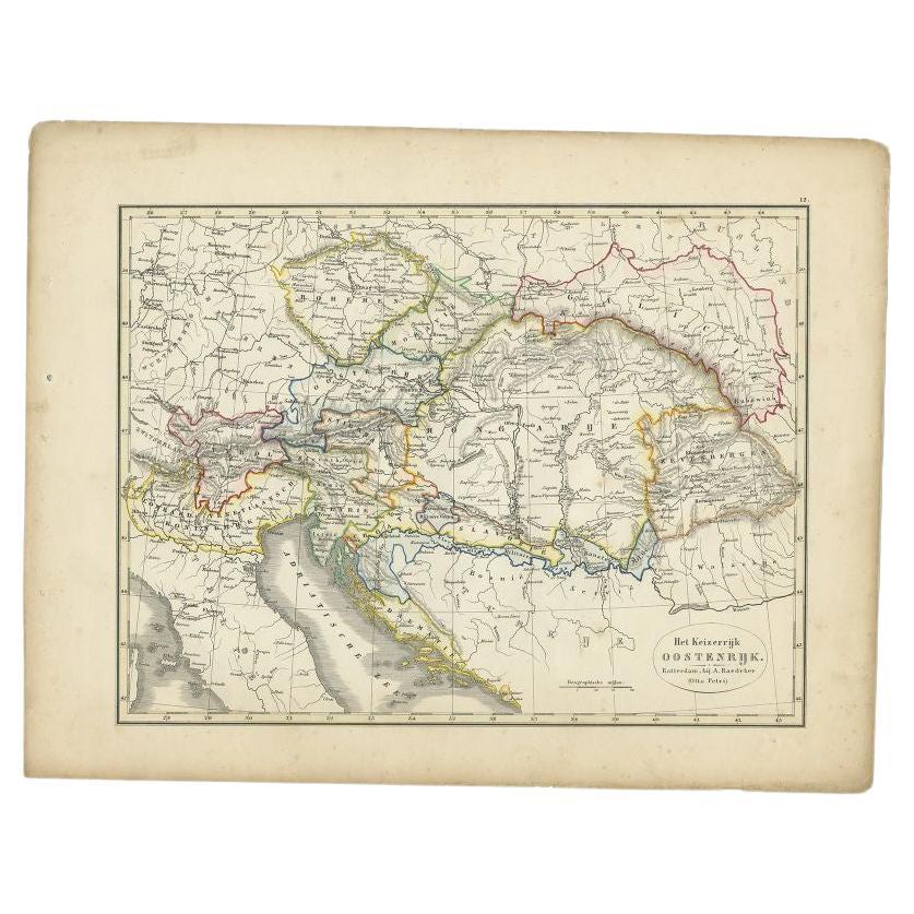
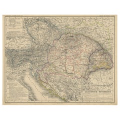
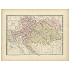
Antique map titled 'Het Keizerrijk Oostenrijk'.
Map of the Austrian Empire. This map originates from 'School-Atlas van alle deelen der Aarde' by Otto Petri.
Artists and Engravers: Published by A. Baedeker (Otto Petri).
Condition: Good, general age-related toning. Minor wear, mainly in margins. Blank verso, please study image carefully.
About the Seller
5.0
Recognized Seller
These prestigious sellers are industry leaders and represent the highest echelon for item quality and design.
Platinum Seller
Premium sellers with a 4.7+ rating and 24-hour response times
Established in 2009
1stDibs seller since 2017
2,533 sales on 1stDibs
Typical response time: <1 hour
- ShippingRetrieving quote...Shipping from: Langweer, Netherlands
- Return Policy
Authenticity Guarantee
In the unlikely event there’s an issue with an item’s authenticity, contact us within 1 year for a full refund. DetailsMoney-Back Guarantee
If your item is not as described, is damaged in transit, or does not arrive, contact us within 7 days for a full refund. Details24-Hour Cancellation
You have a 24-hour grace period in which to reconsider your purchase, with no questions asked.Vetted Professional Sellers
Our world-class sellers must adhere to strict standards for service and quality, maintaining the integrity of our listings.Price-Match Guarantee
If you find that a seller listed the same item for a lower price elsewhere, we’ll match it.Trusted Global Delivery
Our best-in-class carrier network provides specialized shipping options worldwide, including custom delivery.More From This Seller
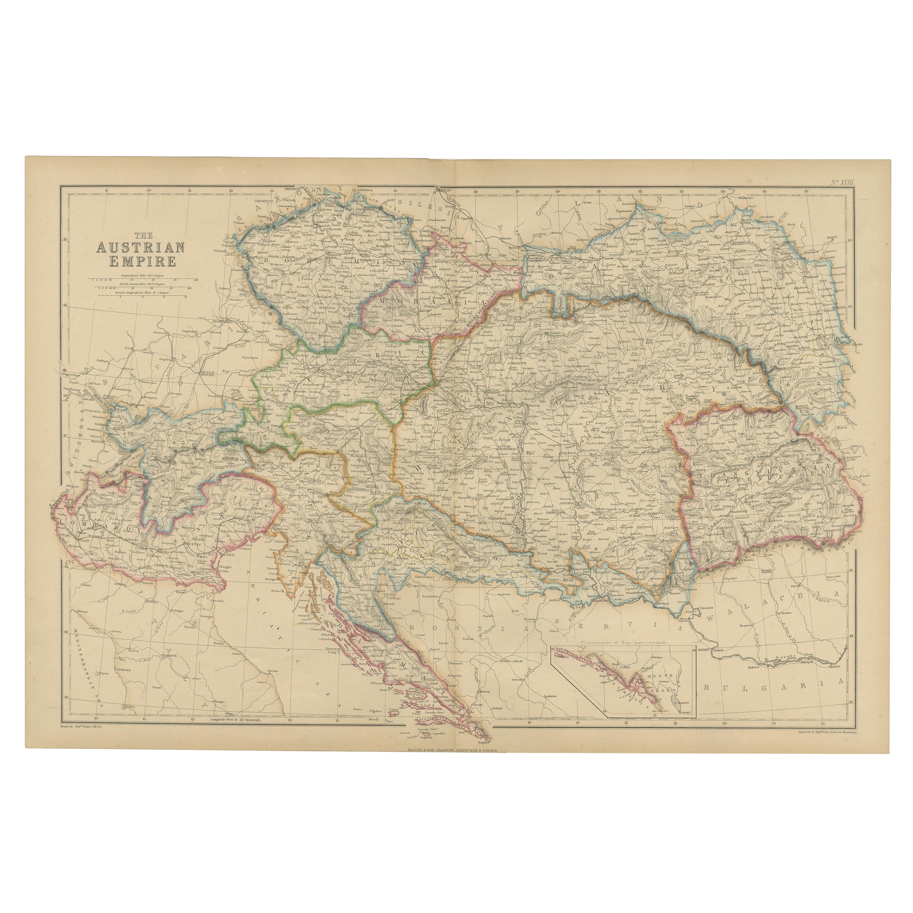
View AllAntique Map of the Austrian Empire by W. G. Blackie, 1859
Located in Langweer, NL
Antique map titled 'The Austrian Empire'. Original antique map of the Austrian Empire with inset map of Montenegro. This map originates from ‘The Imperial Atlas of Modern Geography’....
Category
Antique Mid-19th Century Maps
Materials
Paper
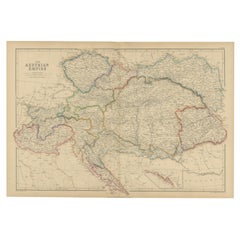
$206 Sale Price
30% Off
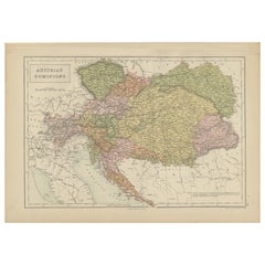
Antique Map of the Austrian Empire by Petri, 1852
Located in Langweer, NL
Antique map titled 'Het Keizerrijk Oostenrijk'. Map of the Austrian Empire. This map originates from 'School-Atlas van alle deelen der Aarde' by Otto Petri....
Category
Antique 19th Century Maps
Materials
Paper

$113 Sale Price
20% Off
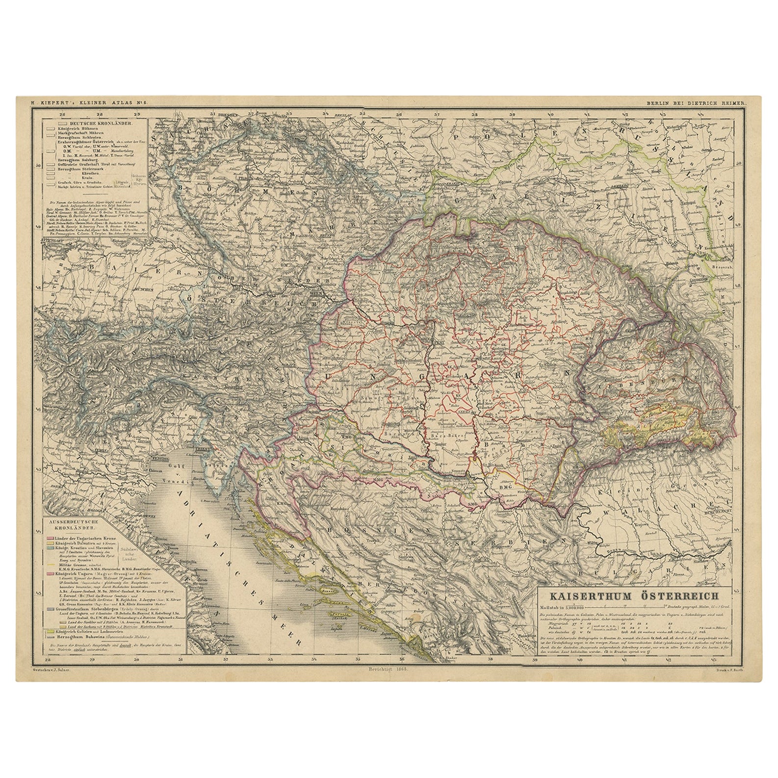
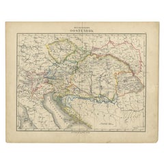
Old German Map of the Austrian Empire, ca.1870
Located in Langweer, NL
Antique map titled 'Kaiserthum Österreich'.
Old map of the Austrian Empire. This map originates from 'H. Kiepert's Kleiner Atlas der Neueren Geographie für Schule und Haus'.
Arti...
Category
Antique 1870s Maps
Materials
Paper
$273 Sale Price
20% Off
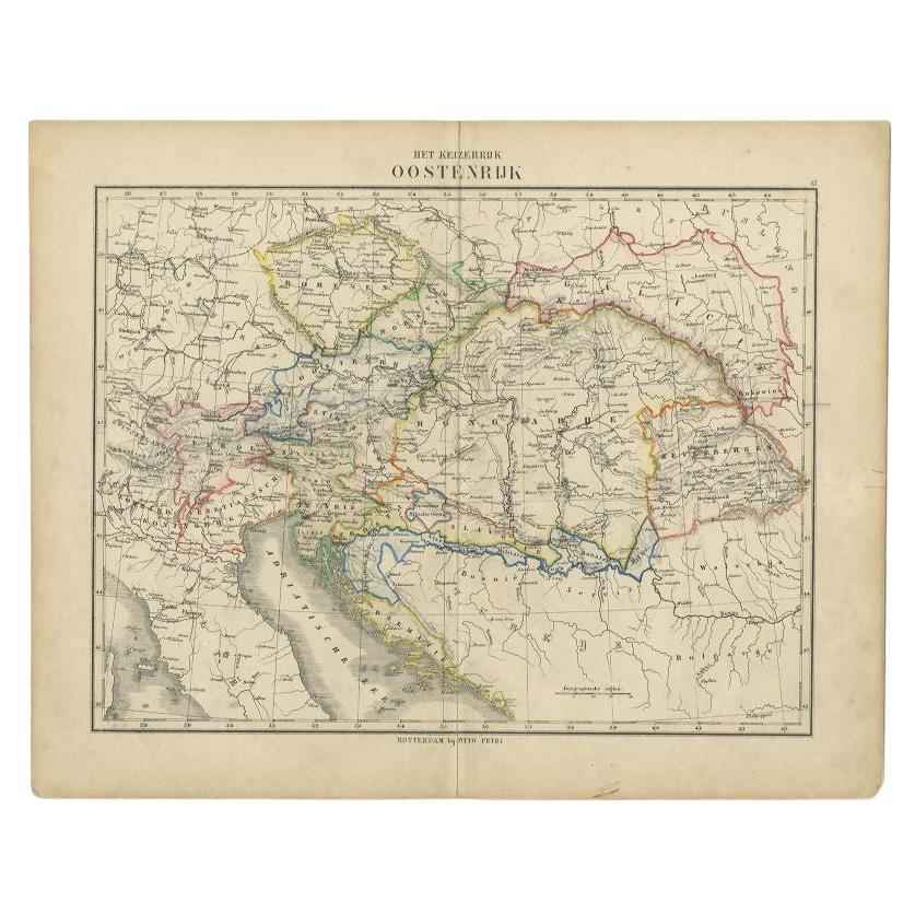
Antique Map of the Austrian Empire by Petri, c.1873
Located in Langweer, NL
Antique map titled 'Het Keizerrijk Oostenrijk'. Old map depicting the Austrian Empire. This map originates from 'School-Atlas van alle Deelen der Aarde'. Artists and Engravers: Publi...
Category
Antique 19th Century Maps
Materials
Paper
$87 Sale Price
20% Off
Antique Map of Austria-Hungary by Levasseur, '1875'
Located in Langweer, NL
Antique map titled 'Carte générale de la Monarchie Austro-Hongroise (..)'. Large map of Austria-Hungary. This map originates from 'Atlas de Géographie M...
Category
Antique Late 19th Century Maps
Materials
Paper
$306 Sale Price
35% Off
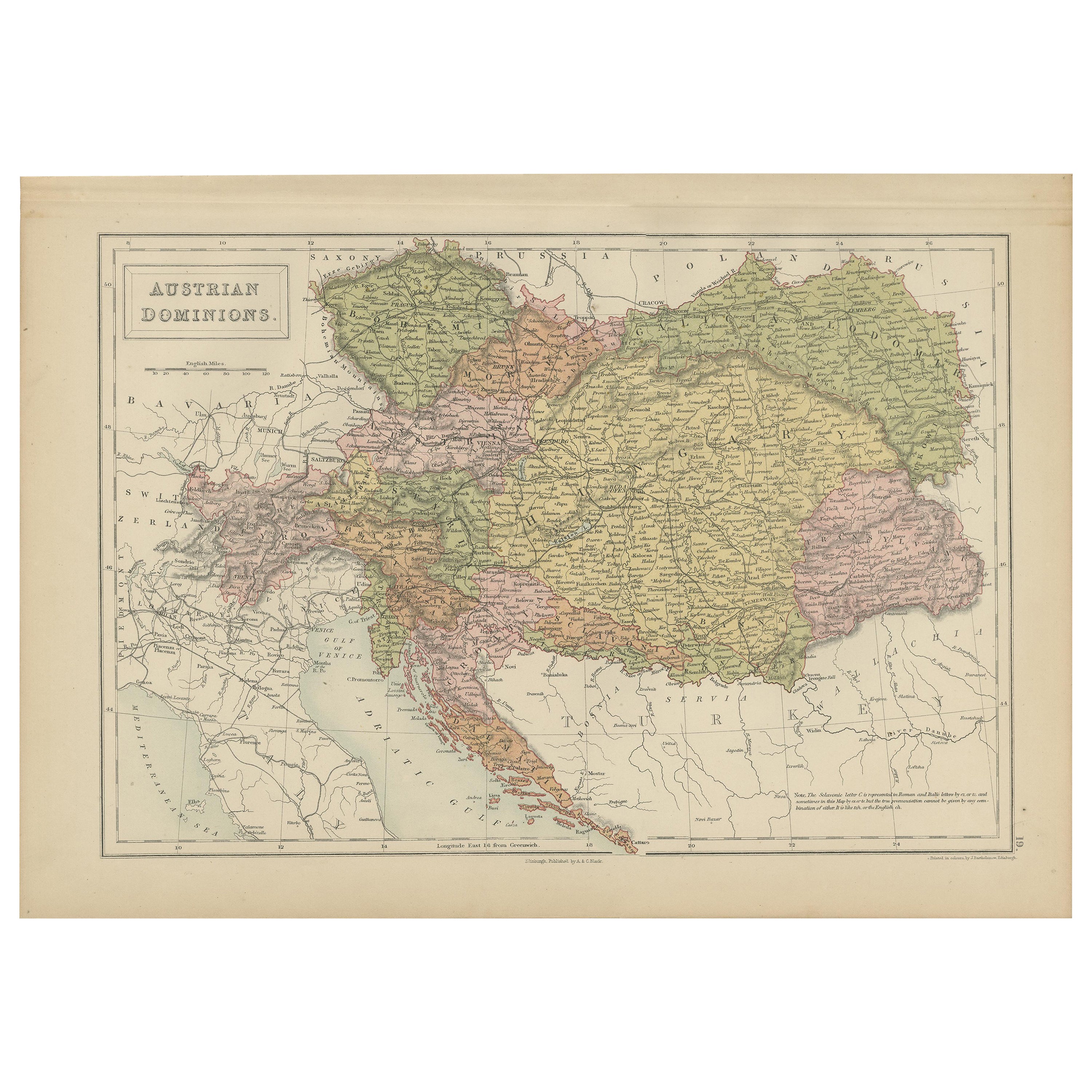
Antique Map of Austrian Dominions by A & C. Black, 1870
Located in Langweer, NL
Antique map titled 'Austrian Dominions'. Original antique map of Austrian Dominions. This map originates from ‘Black's General Atlas of The Worl...
Category
Antique Late 19th Century Maps
Materials
Paper
$165 Sale Price
20% Off
You May Also Like
Austria-Hungary, Western Part. Century Atlas antique vintage map
Located in Melbourne, Victoria
'The Century Atlas. Austria-Hungary, Western Part'
Original antique map, 1903.
Central fold as issued. Map name and number printed on the reverse corners.
Sheet 40cm by 29.5cm.
Category
Early 20th Century Victorian More Prints
Materials
Lithograph

Large Original Antique Map of Poland by Sidney Hall, 1847
Located in St Annes, Lancashire
Great map of Poland
Drawn and engraved by Sidney Hall
Steel engraving
Original colour outline
Published by A & C Black. 1847
Unframed
...
Category
Antique 1840s Scottish Maps
Materials
Paper

17th Century Nicolas Visscher Map of Southeastern Europe
Located in Hamilton, Ontario
A beautiful, highly detailed map of southeastern Europe by Nicolas Visscher. Includes regions of Northern Italy (showing the cities Bologna, Padua, and Venice), Bohemia, Austria (sho...
Category
Antique 17th Century Dutch Maps
Materials
Paper

$1,350 Sale Price
38% Off
1849 Map of "Europaische Russland", 'Meyer Map of European Russia', Ric. R017
Located in Norton, MA
1849 Map of
"Europaische Russland"
( Meyer Map of European Russia)
Ric.r017
A lovely map of European Russia dating to 1849 by Joseph Meyer. It covers the European portions of...
Category
Antique 19th Century Unknown Maps
Materials
Paper

1853 Map of "Russia in Europe Including Poland" Ric.r016
Located in Norton, MA
Description
Russia in Europe incl. Poland by J Wyld c.1853
Hand coloured steel engraving
Dimension: Paper: 25 cm W x 33 cm H ; Sight: 22 cm W x 28 cm H
Condition: Good ...
Category
Antique 19th Century Unknown Maps
Materials
Paper

Original Antique Map of Hungary, Arrowsmith, 1820
Located in St Annes, Lancashire
Great map of Hungary
Drawn under the direction of Arrowsmith.
Copper-plate engraving.
Published by Longman, Hurst, Rees, Orme and Brown, 1820
Unframed.
Category
Antique 1820s English Maps
Materials
Paper

More Ways To Browse
Dutch School Furniture
Austrian Empire
Otto Petri
World Map Of Trade Routes
Albanian Antique
Antique Furniture Wiltshire
Antique Maps Of Israel
Framed Africa Maps
Antique Furniture Goa
Croatian Antiques
Map Of Israel
Teak Sphere
18th Century Scottish Collectibles
Map Of Mexican California
Ottoman Map
Antique Map Of Korea
Maps South East Asia
Antique Furniture Kansas City