Items Similar to Original Antique Map of Central America / Florida, Arrowsmith, 1820


Want more images or videos?
Request additional images or videos from the seller
1 of 6
Original Antique Map of Central America / Florida, Arrowsmith, 1820
$45
£34.62
€40.18
CA$63.46
A$71.09
CHF 37.34
MX$864.39
NOK 472.81
SEK 448.83
DKK 299.88
About the Item
Great map of Central America.
Drawn under the direction of Arrowsmith.
Copper-plate engraving.
Published by Longman, Hurst, Rees, Orme and Brown, 1820
Unframed.
- Dimensions:Height: 10.5 in (26.67 cm)Width: 16 in (40.64 cm)Depth: 0.07 in (1.78 mm)
- Materials and Techniques:Paper,Other
- Place of Origin:
- Period:
- Date of Manufacture:1820
- Condition:Wear consistent with age and use.
- Seller Location:St Annes, GB
- Reference Number:1stDibs: LU1836331113542
About the Seller
4.9
Platinum Seller
Premium sellers with a 4.7+ rating and 24-hour response times
1stDibs seller since 2016
3,116 sales on 1stDibs
Typical response time: 1 hour
Associations
International Confederation of Art and Antique Dealers' Associations
- ShippingRetrieving quote...Shipping from: St Annes, United Kingdom
- Return Policy
Authenticity Guarantee
In the unlikely event there’s an issue with an item’s authenticity, contact us within 1 year for a full refund. DetailsMoney-Back Guarantee
If your item is not as described, is damaged in transit, or does not arrive, contact us within 7 days for a full refund. Details24-Hour Cancellation
You have a 24-hour grace period in which to reconsider your purchase, with no questions asked.Vetted Professional Sellers
Our world-class sellers must adhere to strict standards for service and quality, maintaining the integrity of our listings.Price-Match Guarantee
If you find that a seller listed the same item for a lower price elsewhere, we’ll match it.Trusted Global Delivery
Our best-in-class carrier network provides specialized shipping options worldwide, including custom delivery.More From This Seller
View AllOriginal Antique Map of North America by Dower, circa 1835
Located in St Annes, Lancashire
Nice map of North America
Drawn and engraved by J.Dower
Published by Orr & Smith. C.1835
Unframed.
Free shipping
Category
Antique 1830s English Maps
Materials
Paper

Original Antique Map of The Western Hemisphere by Dower, circa 1835
Located in St Annes, Lancashire
Nice map of the Western Hemisphere
Drawn and engraved by J.Dower
Published by Orr & Smith. C.1835
Unframed.
Free shipping
Category
Antique 1830s English Maps
Materials
Paper

Original Antique Map of The United States of America by Dower, circa 1835
Located in St Annes, Lancashire
Nice map of the USA
Drawn and engraved by J.Dower
Published by Orr & Smith. C.1835
Unframed.
Free shipping
Category
Antique 1830s English Maps
Materials
Paper

Original Antique Map of The World by Dower, circa 1835
Located in St Annes, Lancashire
Nice map of the World
Drawn and engraved by J.Dower
Published by Orr & Smith. C.1835
Unframed.
Free shipping
Category
Antique 1830s English Maps
Materials
Paper

Original Antique Map of South America. C.1780
Located in St Annes, Lancashire
Great map of South America
Copper-plate engraving
Published C.1780
Two small worm holes to left side of map
Unframed.
Category
Antique Early 1800s English Georgian Maps
Materials
Paper

Large Original Antique Map of The West Indies by Sidney Hall, 1847
Located in St Annes, Lancashire
Great map of The West Indies
Drawn and engraved by Sidney Hall
Steel engraving
Original colour outline
Published by A & C Black. 1847
Unframed
Free shipping.
Category
Antique 1840s Scottish Maps
Materials
Paper

You May Also Like
Original Antique Map of the West Indies by J. Arrowsmith, 1842
Located in Langweer, NL
Title: "J. Arrowsmith's 19th Century Map of the West Indies"
This original antique map, crafted by J. Arrowsmith, details the West Indies with a focus on the Caribbean Sea and its s...
Category
Antique Early 19th Century Maps
Materials
Paper

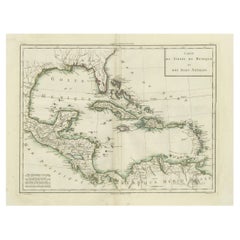
Authentic Antique Map of the Caribbean, Gulf Coast and Central America, 1787
Located in Langweer, NL
Antique map titled 'Les Isles Antilles et le Golfe du Méxique'. Original old map of the Caribbean, Gulf Coast and Central America. With inset map of Bermuda...
Category
Antique Late 18th Century Maps
Materials
Paper

$288 Sale Price
20% Off
Free Shipping
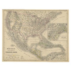
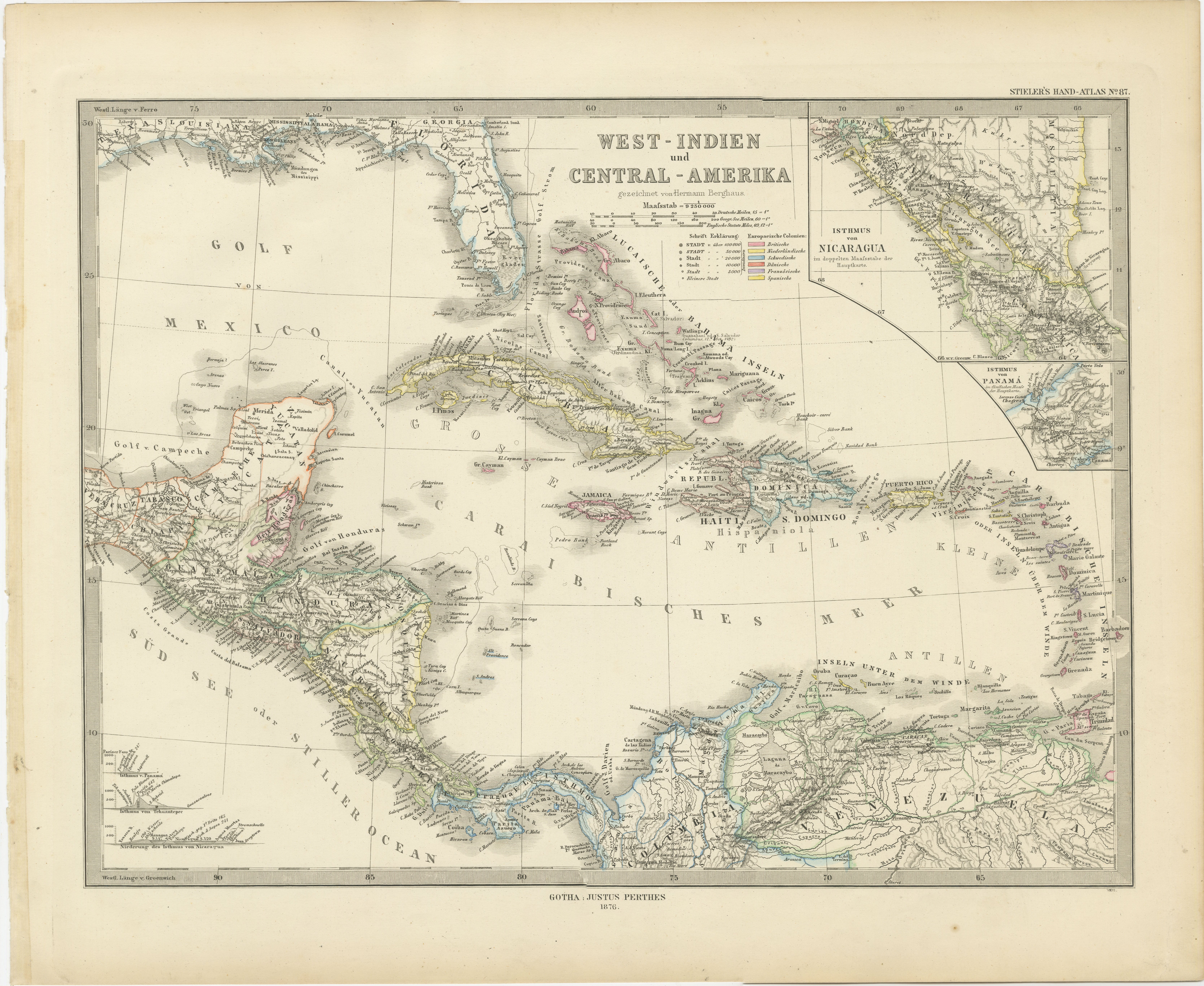
1880 Map of the Caribbean and Central America by Adolf Stieler
Located in Langweer, NL
This is a detailed map titled "West-Indien und Central-Amerika," created by Adolf Stieler and published in Gotha in 1880. The map covers the Caribbean islands and the Central America...
Category
Antique 1880s Maps
Materials
Paper
$270 Sale Price
20% Off
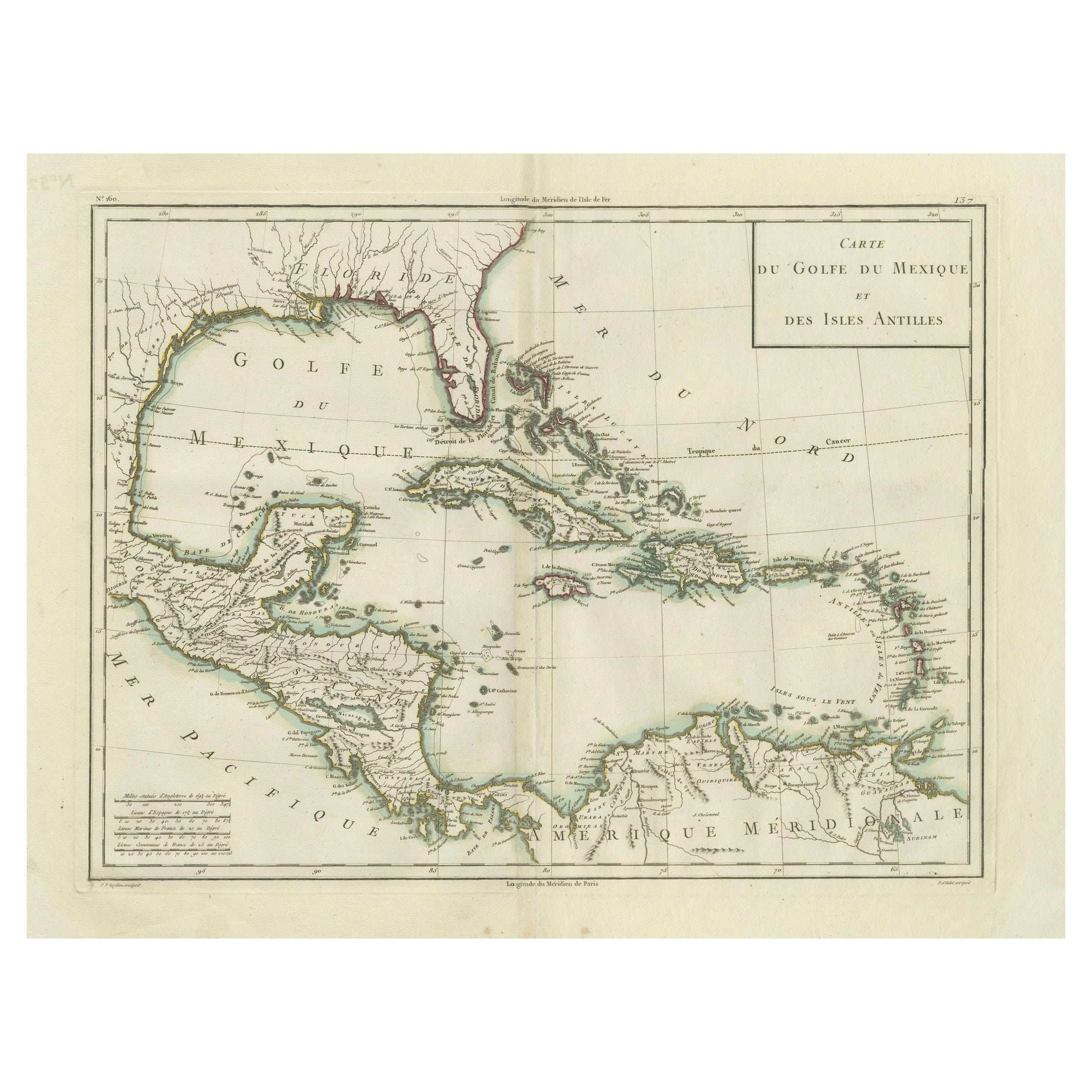
Antique Map of the Gulf of Mexico and Caribbean Islands by Tardieu, 1802
Located in Langweer, NL
This is an original antique map titled "Carte du Golfe du Mexique et des Isles Antilles," depicting the Gulf of Mexico and the Caribbean islands. Created by Pierre Antoine Tardieu, t...
Category
Antique Early 1800s Maps
Materials
Paper
$522 Sale Price
20% Off
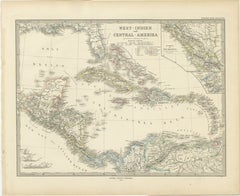
Antique Map of Central America and the West Indies, 1882
Located in Langweer, NL
Antique map titled 'West India Islands and Central America'. Old map of Central America and the West Indies. This map originates from 'The Royal Atlas of Modern Geography, Exhibiting...
Category
Antique 19th Century Maps
Materials
Paper

$167 Sale Price
20% Off
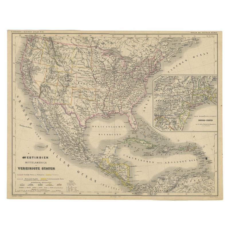
Old German Map of the United States, Central America and the West Indies, c.1870
Located in Langweer, NL
Antique map titled 'Westindien, Mittelamerica und Vereinigte Staten'. Old map of the United States, Central America and the West Indies. This map originates from 'H. Kiepert's Kleine...
Category
Antique 19th Century Maps
Materials
Paper