Items Similar to Original Antique Map of the Duchy of Luxembourg by De Wit, Amsterdam circa 1680


Want more images or videos?
Request additional images or videos from the seller
1 of 11
Original Antique Map of the Duchy of Luxembourg by De Wit, Amsterdam circa 1680
$2,003.66
£1,509.15
€1,700
CA$2,763.13
A$3,104.25
CHF 1,621.98
MX$37,888.87
NOK 20,594.38
SEK 19,385.27
DKK 12,939.75
About the Item
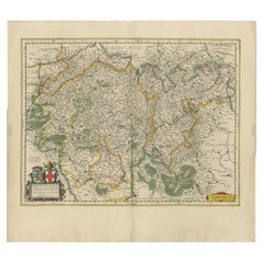
Map of the Duchy of Luxembourg by De Wit, Amsterdam circa 1680
Rare original antique map of the Duchy of Luxembourg by Frederick de Wit, published in Amsterdam circa 1680. A highly decorative 17th-century collectible.
This rare and beautifully engraved map titled Ducatus Lutzenburgici Tabula Nuperrime in Lucem Edita was published around 1680 by the renowned Amsterdam cartographer Frederick de Wit. It offers a detailed representation of the Duchy of Luxembourg and its surrounding regions, capturing the complex political geography of late 17th-century Europe.
The map is rich in detail, featuring mountains, forests, rivers, and a dense network of towns and villages. Key cities such as Luxembourg, Bastogne, Arlon, and Neufchâteau are marked with red symbols, while delicate hachuring illustrates the region’s varied topography. Hand-colored borders distinguish the different provinces, reflecting territorial divisions under the Holy Roman Empire.
The decorative elements are particularly charming. The upper right features two cherubs holding surveying instruments, symbolizing cartographic science, while the lower right corner shows a female figure representing Luxembourg beside the province’s red lion coat of arms. These vignettes are both decorative and emblematic, enhancing the artistic and historic appeal of the map.
Frederick de Wit (circa 1629–1706) was one of the foremost Dutch map publishers of the Golden Age. His *Atlas sive Descriptio Terrarum Orbis* was a major cartographic work of the late 17th century, and his maps are celebrated for their precision, beauty, and decorative qualities. This map of the Duchy of Luxembourg is a fine example of his craftsmanship and remains a scarce find, particularly in such well-preserved condition.
Condition summary:
Overall in very good condition with strong hand-coloring. One small tear on a green border from oxidation, otherwise clean with full margins and sharp detail. A fine and rare map of 17th-century Luxembourg.
Framing tip:
Frame with a deep walnut or gold-burnished frame and a soft cream or ivory mat. UV-protective glass is advised to preserve the original colors and delicate engraving. Ideal for classical, historical, or diplomatic interiors.
- Dimensions:Height: 20.67 in (52.5 cm)Width: 23.75 in (60.3 cm)Depth: 0.01 in (0.2 mm)
- Materials and Techniques:Paper,Engraved
- Place of Origin:
- Period:Late 17th Century
- Date of Manufacture:circa 1680
- Condition:Overall in very good condition with strong hand-coloring. One small tear on a green border from oxidation, otherwise clean with full margins and sharp detail. A fine and rare map of 17th-century Luxembourg.
- Seller Location:Langweer, NL
- Reference Number:Seller: BG-14092-11stDibs: LU3054345467652
About the Seller
5.0
Recognized Seller
These prestigious sellers are industry leaders and represent the highest echelon for item quality and design.
Platinum Seller
Premium sellers with a 4.7+ rating and 24-hour response times
Established in 2009
1stDibs seller since 2017
2,534 sales on 1stDibs
Typical response time: <1 hour
- ShippingRetrieving quote...Shipping from: Langweer, Netherlands
- Return Policy
Authenticity Guarantee
In the unlikely event there’s an issue with an item’s authenticity, contact us within 1 year for a full refund. DetailsMoney-Back Guarantee
If your item is not as described, is damaged in transit, or does not arrive, contact us within 7 days for a full refund. Details24-Hour Cancellation
You have a 24-hour grace period in which to reconsider your purchase, with no questions asked.Vetted Professional Sellers
Our world-class sellers must adhere to strict standards for service and quality, maintaining the integrity of our listings.Price-Match Guarantee
If you find that a seller listed the same item for a lower price elsewhere, we’ll match it.Trusted Global Delivery
Our best-in-class carrier network provides specialized shipping options worldwide, including custom delivery.More From This Seller
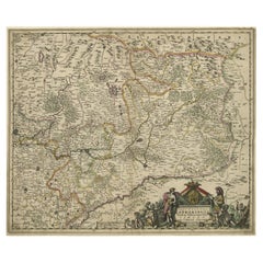
View AllAntique Map of the Namur Region 'France' by F. de Wit, circa 1680
Located in Langweer, NL
Antique map titled 'Comitatus Namurci Tabula in Lucem Edita'. Large map of the Namur region, France. Published by F. de Wit, circa 1680.
Category
Antique Late 17th Century Maps
Materials
Paper

$542 Sale Price
20% Off
Antique Map of the Hainaut Region 'France' by F. de Wit, circa 1680
Located in Langweer, NL
Antique map titled 'Comitatus Hannoniae et Episcopatus Cambresis Descriptio'. Large map of the Hainaut region, France. Published by F. de Wit, circa 1680.
Category
Antique Late 17th Century Maps
Materials
Paper

$542 Sale Price
20% Off
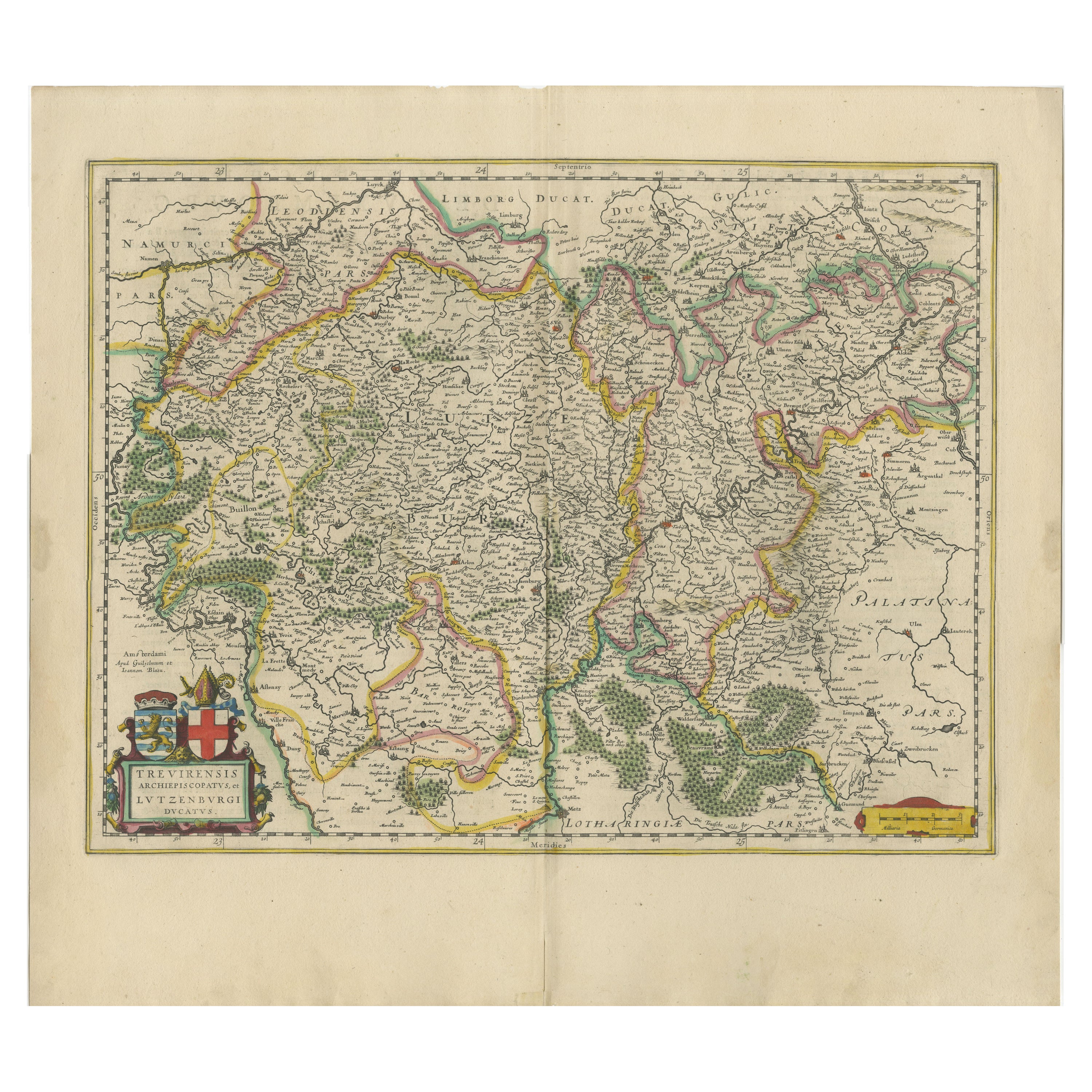
Original Antique Map of Trier and Luxembourg by Joan Blaeu, Amsterdam circa 1640
Located in Langweer, NL
Map of Trier and Luxembourg by Joan Blaeu, Amsterdam circa 1640
This beautifully engraved and hand-colored map titled Trevirensis Archiepiscopatus, et Lutzenburgi Ducatus depicts th...
Category
Antique Mid-17th Century Dutch Maps
Materials
Paper
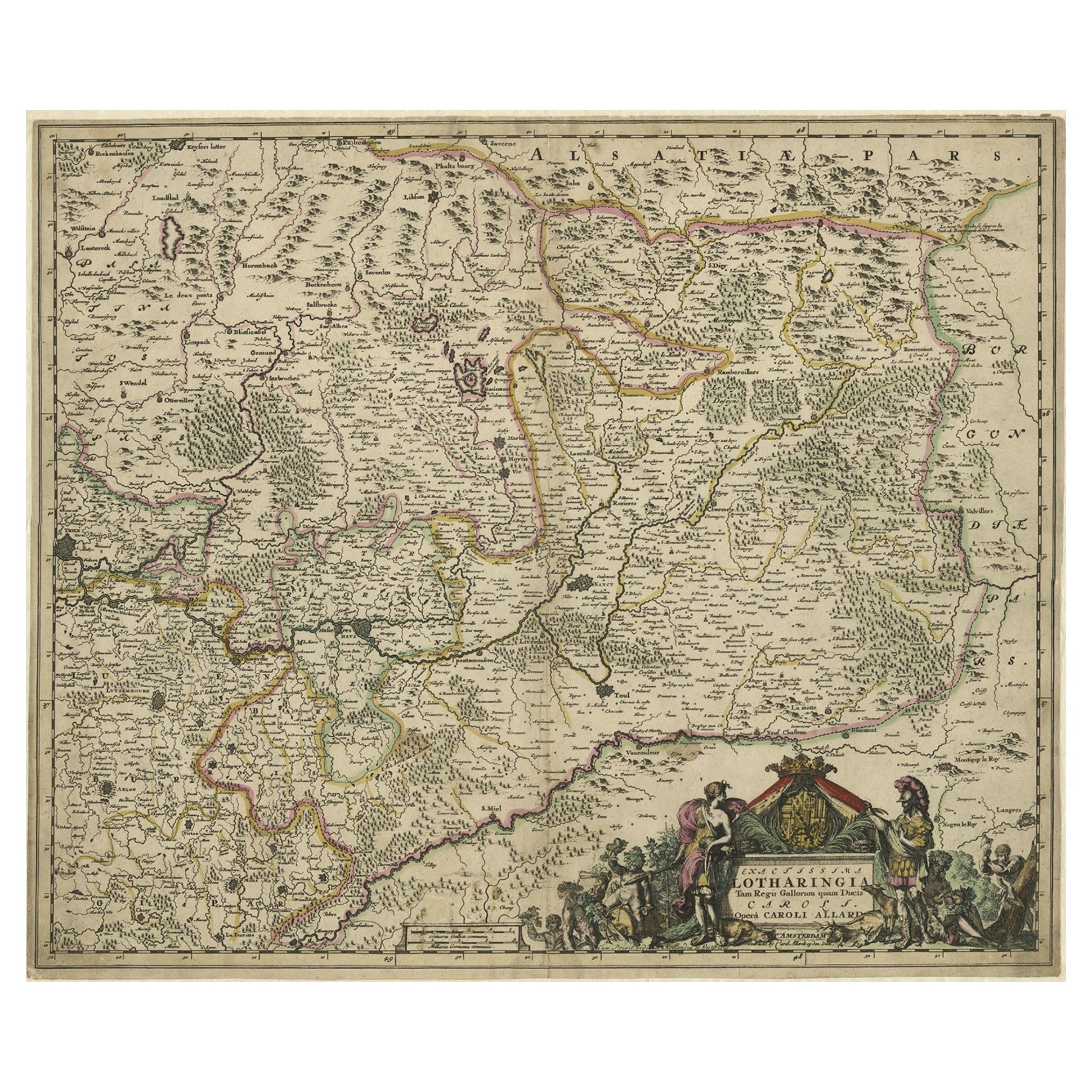
Striking Antique Map of Luxembourg and Northern France 'Lotharingen', c.1680
Located in Langweer, NL
Description: Antique map titled 'Exactissima Lotharingia tam Regis Gallorum quam Ducis.' -
Striking map of Luxembourg and Northern France. Includ...
Category
Antique 1680s Maps
Materials
Paper
$612 Sale Price
20% Off
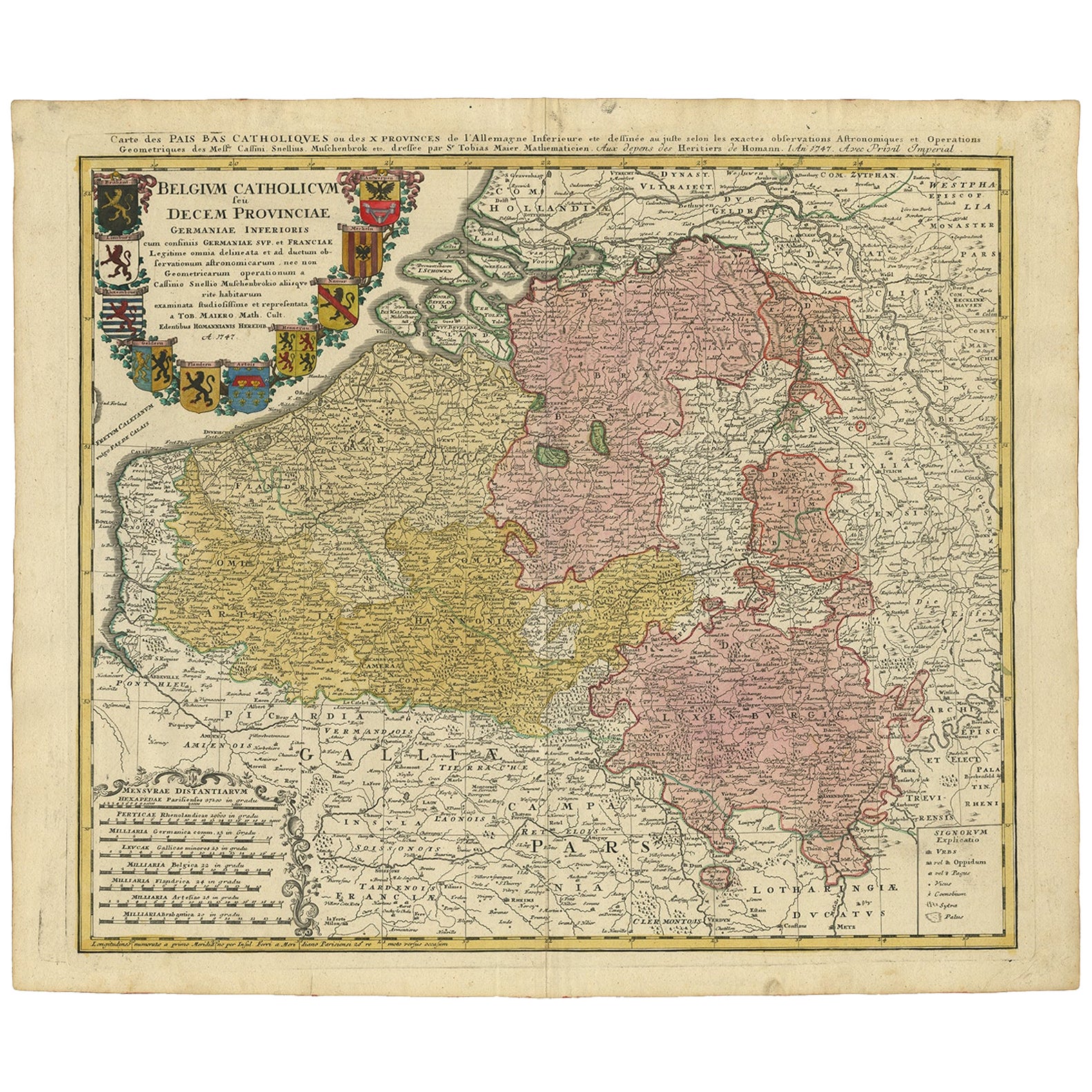
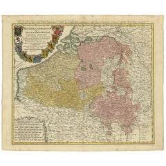
Antique Map of Belgium and Luxembourg by Homann Heirs, 1747
Located in Langweer, NL
Antique map titled 'Belgium Catholicum seu Decem provinciae Germaniae Inferioris cum confiniis Germaniae sup. et Francia (..).' Detailed map of Belgium and Luxembourg showing parts o...
Category
Antique 18th Century Maps
Materials
Paper
$424 Sale Price
20% Off
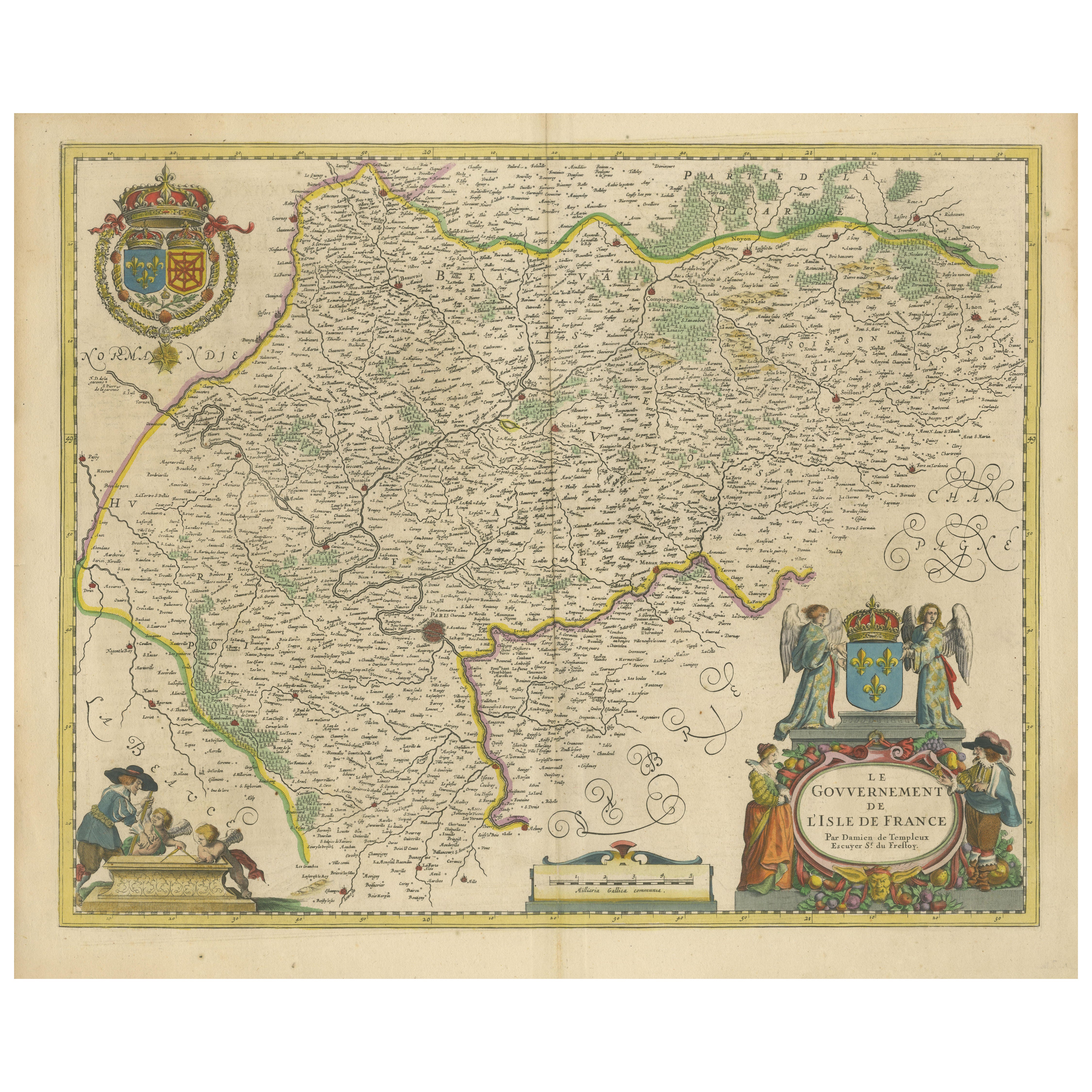
Beautiful 17th Century Map of Paris and Isle de France by Templeux, c.1650
Located in Langweer, NL
Map of Isle de France by D. de Templeux, ca. 1650, Hand-Colored and Decorative
This richly detailed antique map titled *Le Gouvernement de L'Isle de France* was engraved by Daniel d...
Category
Antique 1650s Maps
Materials
Paper

You May Also Like
West Germany: Original Hand Colored 17th Century Map by Johannes Janssonius
By Johannes Janssonius
Located in Alamo, CA
An original hand colored copperplate engraved map entitled in Latin "Archiepiscopatus Maghdeburgensis et Anhaltinus Ducatus cum terris adjacentibus", published in Amsterdam in 1640 i...
Category
Mid-17th Century Old Masters More Prints
Materials
Engraving

1640 Joan Bleau Map Entitled"Diocecese de rheims et le pais de rethel, " Eic.a011
Located in Norton, MA
1640 Joan Bleau map entitled
"Diocecese de rheims et le pais de rethel,"
Ric.a011
OAN BLAEU
Diocecese de Rheims, et le pais de Rethel.
Handcolored engraving, c.1640.
...
Category
Antique 17th Century Dutch Maps
Materials
Paper

1752 Vaugoundy Map of Flanders : Belgium, France, and the Netherlands, Ric.a002
Located in Norton, MA
Large Vaugoundy Map of Flanders:
Belgium, France, and the Netherlands
Colored -1752
Ric.a002
Description: This is a 1752 Didier Robert de Vaugondy map of Flanders. The map de...
Category
Antique 17th Century Unknown Maps
Materials
Paper

1635 Willem Blaeu Map of Northern France"Comitatvs Bellovacvm" Ric.a08
Located in Norton, MA
1635 Willem Blaeu map of northern France, entitled.
"Comitatvs Bellovacvm Vernacule Beavvais,"
Colored
Ric.a008
“COMITATVS BELLOVACVM…” Amsterdam: W...
Category
Antique 17th Century Unknown Maps
Materials
Paper

1656 Jansson Map Metz Region of France Entitled "Territorium Metense" Ric0014
Located in Norton, MA
1656 Jansson map Metz Region of France entitled "Territorium Metense."
Ric0014
" Authentic" - Map of the historical region surrounding Metz, in Lorraine, France.
Oriented with ...
Category
Antique 17th Century Dutch Maps
Materials
Paper

L'Isle de France: A Hand-colored 17th Century Map by De Wit
By Frederick de Wit
Located in Alamo, CA
This colorful and detailed 17th century hand-colored copperplate map by Frederick De Wit was published in Amsterdam between 1666 and 1760. The map depicts the Île-de-France, which is one of the ancient provinces of France. Paris is located in the center of the map, with Versailles to the southwest The map extends from Rouen in the west to Reims in the east. The area around Paris, the Véxin Français, was the original domain of the king of France. Other areas were ruled by French feudal lords. For example, the Véxin Normand area was the domain of the Duke of Normandy...
Category
Early 18th Century Old Masters More Prints
Materials
Engraving

More Ways To Browse
Red Lion
Antique Ivory Collectables
Antique Village Soft
Coat Of Arms Engraving
Coat Of Arms Lions
Lion Engraving
Surveying Instrument
Antique Survey Instruments
Antique Surveying Instruments
Styles Of Antique Desks
Black And White Coffee Table
Curved Velvet Couch
Velvet Curved Sofa
Wood Round Coffee Tables
Antique Paper Flowers
Oak Brutalist
Used College Furniture
Wood Minimalist Chair