Items Similar to Original Chart Showing the Region between Cape Grenville and Cape Suckling, 1803


Want more images or videos?
Request additional images or videos from the seller
1 of 5
Original Chart Showing the Region between Cape Grenville and Cape Suckling, 1803
$546.35
$682.9420% Off
£406.72
£508.4120% Off
€456
€57020% Off
CA$748.37
CA$935.4620% Off
A$832.35
A$1,040.4420% Off
CHF 434.63
CHF 543.2820% Off
MX$10,128.79
MX$12,660.9920% Off
NOK 5,550.84
NOK 6,938.5520% Off
SEK 5,205.71
SEK 6,507.1420% Off
DKK 3,471.37
DKK 4,339.2120% Off
Shipping
Retrieving quote...The 1stDibs Promise:
Authenticity Guarantee,
Money-Back Guarantee,
24-Hour Cancellation
About the Item
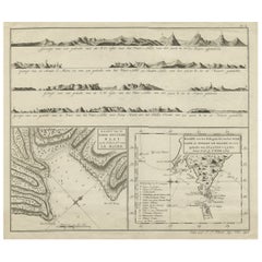
Antique map titled 'Kaart van Cook's Rivier in het N.O. gedeelte van Amerika'.
Chart showing the region between Cape Grenville and Cape Suckling, including Whitsuntide Bay, Cape Whitsunday, Smokey Bay, Cape Douglas, Mount St. Augustine, Volcano Mountain, R. Turn-again, Cook's River, Point Possession, Anchor Point, Point Beale Cape Elizabeth Montagu Isle, Prince William Sound, Snug Corner Bay, Comptrollers Bay and Cape Hinchingbrook. Originates from 'Reizen Rondom de Waereld door James Cook (..)'.
Artists and Engravers: Translated by J.D. Pasteur. Published by Honkoop, Allart en Van Cleef.
- Dimensions:Height: 11.62 in (29.5 cm)Width: 19.49 in (49.5 cm)Depth: 0 in (0.02 mm)
- Materials and Techniques:
- Period:
- Date of Manufacture:1803
- Condition:Wear consistent with age and use. Condition: Very good, general age-related toning and minor foxing. Please study image carefully.
- Seller Location:Langweer, NL
- Reference Number:Seller: BG-11487-14 1stDibs: LU3054327134942
About the Seller
5.0
Recognized Seller
These prestigious sellers are industry leaders and represent the highest echelon for item quality and design.
Platinum Seller
Premium sellers with a 4.7+ rating and 24-hour response times
Established in 2009
1stDibs seller since 2017
2,508 sales on 1stDibs
Typical response time: <1 hour
- ShippingRetrieving quote...Shipping from: Langweer, Netherlands
- Return Policy
Authenticity Guarantee
In the unlikely event there’s an issue with an item’s authenticity, contact us within 1 year for a full refund. DetailsMoney-Back Guarantee
If your item is not as described, is damaged in transit, or does not arrive, contact us within 7 days for a full refund. Details24-Hour Cancellation
You have a 24-hour grace period in which to reconsider your purchase, with no questions asked.Vetted Professional Sellers
Our world-class sellers must adhere to strict standards for service and quality, maintaining the integrity of our listings.Price-Match Guarantee
If you find that a seller listed the same item for a lower price elsewhere, we’ll match it.Trusted Global Delivery
Our best-in-class carrier network provides specialized shipping options worldwide, including custom delivery.More From This Seller
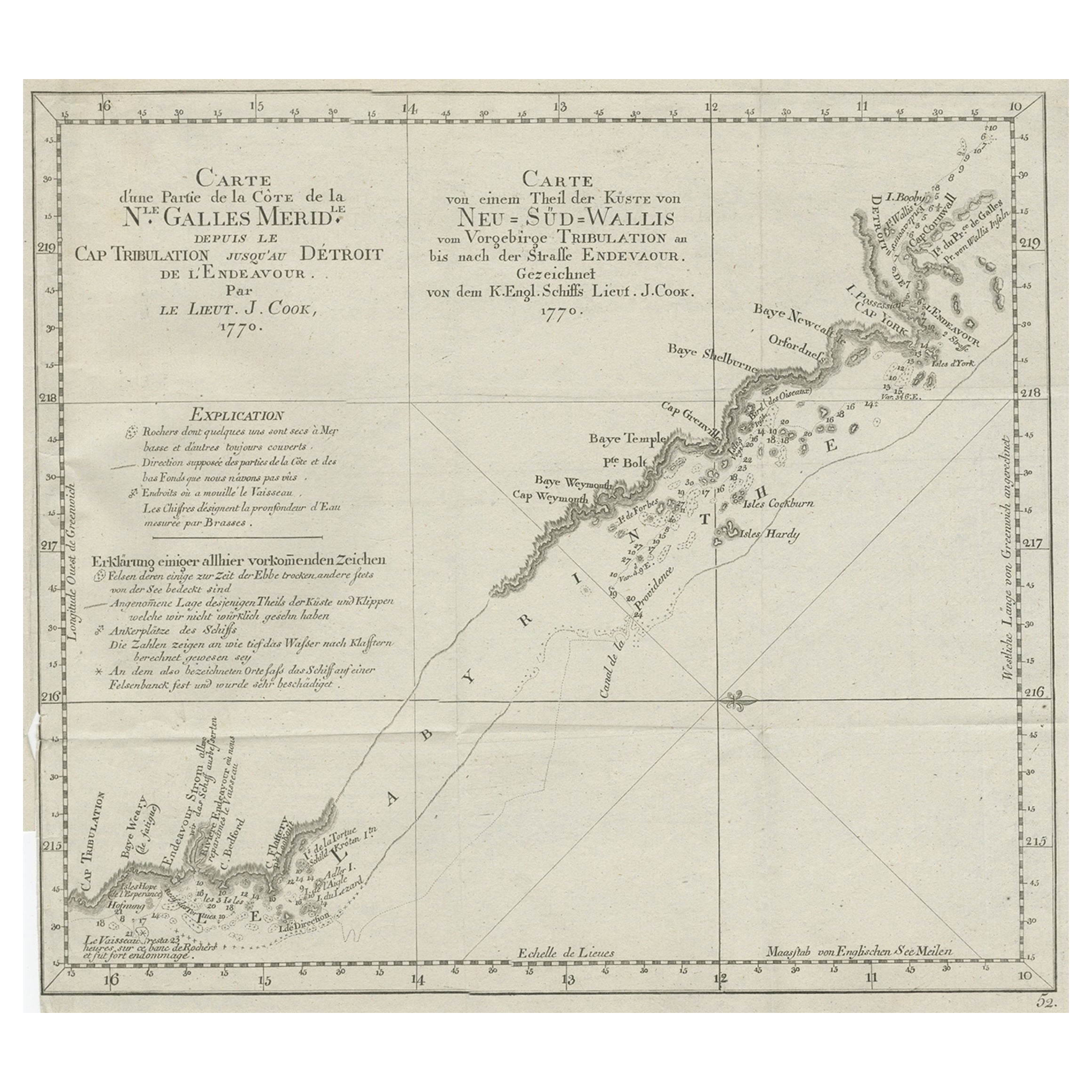
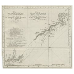
View AllOld Chart of the North-Eastern Coast of Australia Discovered by Cook, 1774
Located in Langweer, NL
Antique print titled Carte d'une Partie de la Cote de la N.le Galles Merid etc.
An interesting chart of the north-eastern coast of Australia discovered by Cook in 1770, showing th...
Category
Antique 1770s Maps
Materials
Paper
$728 Sale Price
20% Off
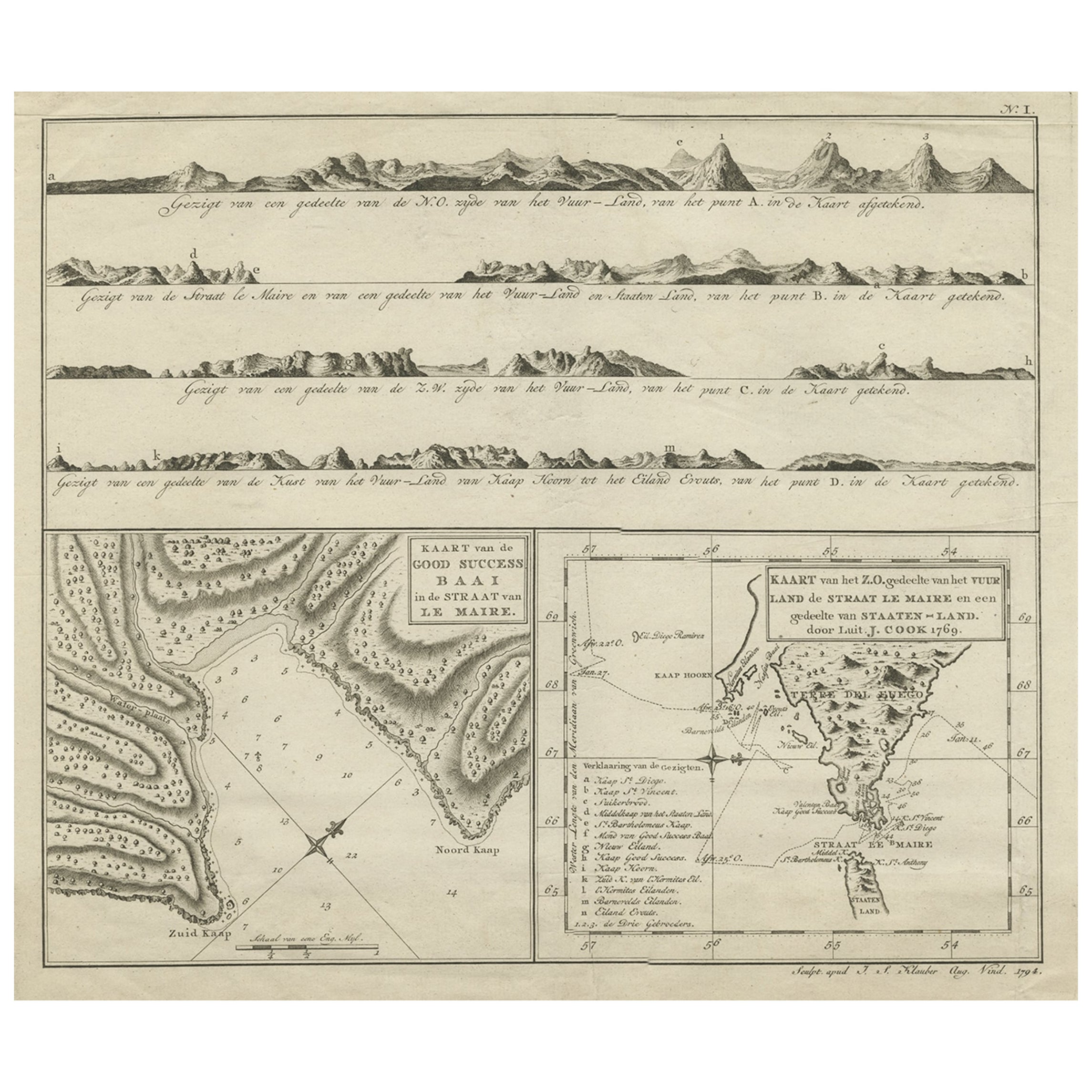
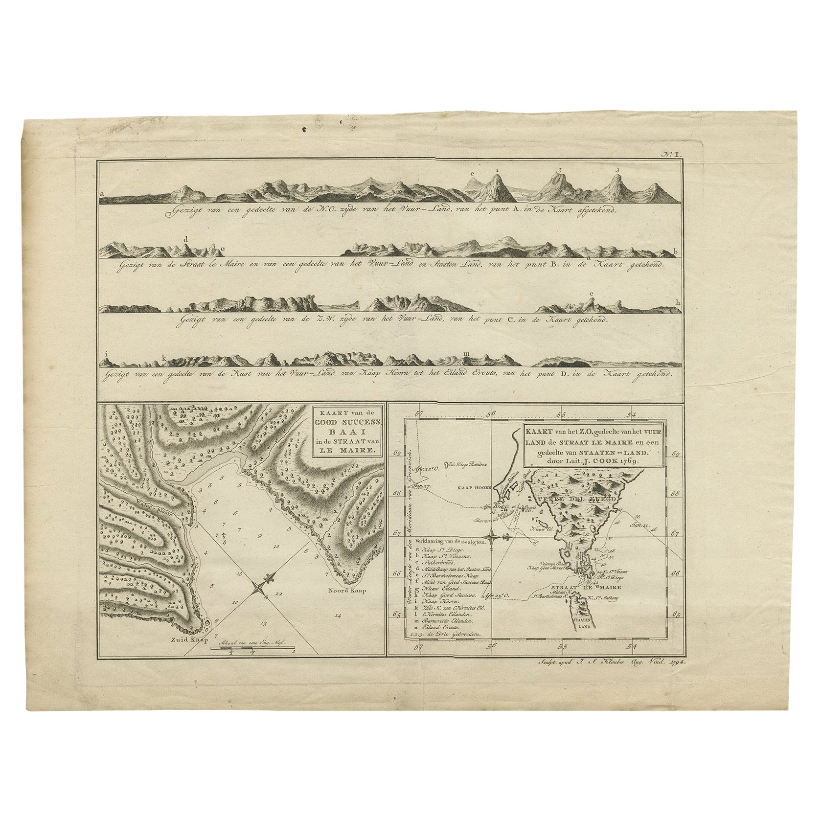
Antique Map of the Strait of Le Maire Between Terra Fuego & Staten Island, 1803
Located in Langweer, NL
Antique map titled 'Kaart van de Good Success Baai in de Straat van Le Maire (..)'.
Antique map of the Strait of Le Maire between Terra Fuego and Staten Island. On top, various c...
Category
Antique Early 1800s Maps
Materials
Paper
$603 Sale Price
20% Off
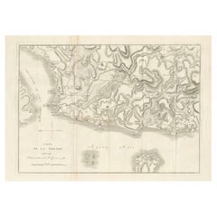
Old Map of Cook's Discovery and Charting of the East Coast of Australia, 1803
Located in Langweer, NL
Antique map titled 'Kaart van Nieuw Zuid Wales of de Oostlyke Kust van Nieuw Holland ontdekt en onderzogt door den Luitenant J. Cook met het Schip de Endeavour in het Jaar 1770'.
...
Category
Antique Early 1800s Maps
Materials
Paper

$1,677 Sale Price
20% Off
Antique Map of the Strait of Le Maire by Cook, 1803
Located in Langweer, NL
Antique map titled 'Kaart van de Good Success Baai in de Straat van Le Maire (..)'. Antique map of the Strait of Le Maire between Terra Fuego and Staten Island. On top, various coast...
Category
Antique 19th Century Maps
Materials
Paper

$603 Sale Price
20% Off
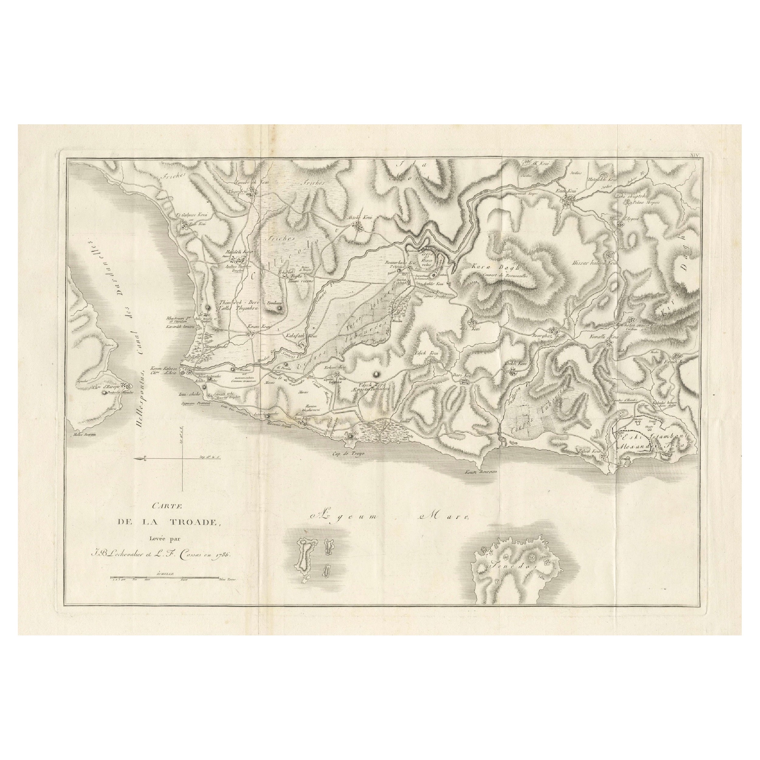
Circa 1802 Map of the Troad Region by Tardieu – From the Voyage de la Troade
Located in Langweer, NL
This is a large fold-out map titled *Carte de la Troade*, measuring approximately 53.5 x 68 cm, engraved by Tardieu, and extracted from the atlas of *Voyage de la Troade, fait dans l...
Category
Antique Early 1800s Maps
Materials
Paper
$239 Sale Price
20% Off
Antique Map of Port Pallisers & Kersmis by Cook, c.1781
Located in Langweer, NL
Antique map Kerguelen titled 'Sketch of Port Palliser on Kerguelen's Land (..)'. Antique map of Port Pallisers & Kersmis, Kerguelen or Desolation Islands. Originates from an edition ...
Category
Antique 18th Century Maps
Materials
Paper

$220 Sale Price
20% Off
You May Also Like
West Coast of Africa, Guinea & Sierra Leone: An 18th Century Map by Bellin
By Jacques-Nicolas Bellin
Located in Alamo, CA
Jacques Bellin's copper-plate map entitled "Partie de la Coste de Guinee Dupuis la Riviere de Sierra Leona Jusquau Cap das Palmas", depicting the coast of Guinea and Sierra Leone in ...
Category
Antique Mid-18th Century French Maps
Materials
Paper

Original Antique Map of South America. C.1780
Located in St Annes, Lancashire
Great map of South America
Copper-plate engraving
Published C.1780
Two small worm holes to left side of map
Unframed.
Category
Antique Early 1800s English Georgian Maps
Materials
Paper

Dartmouth, England: A Hand-Colored 17th Century Sea Chart by Captain Collins
By Captain Greenvile Collins
Located in Alamo, CA
This hand-colored sea chart of the area around Dartmouth, England is from "Great Britain's Coasting Pilot. Being a New and Exact Survey of the Sea-Coast of England", first published ...
Category
Antique Late 17th Century English Maps
Materials
Paper

Original Antique Map of South Africa, Arrowsmith, 1820
Located in St Annes, Lancashire
Great map of South Africa.
Drawn under the direction of Arrowsmith.
Copper-plate engraving.
Published by Longman, Hurst, Rees, Orme and Br...
Category
Antique 1820s English Maps
Materials
Paper

St. Christophe 'St. Kitts' Island: An 18th Century Hand-colored Map by Bellin
By Jacques-Nicolas Bellin
Located in Alamo, CA
Jacques Bellin's copper-plate map of the Caribbean island of Saint Kitts entitled "Carte De De l'Isle St. Christophe Pour servir á l'Histoire Genle. des V...
Category
Antique Mid-18th Century French Maps
Materials
Paper

Long Island Chart from 1828
Located in Norwell, MA
Rare original chart of Long Island Sound by E + G Blunt of New York, 179 Water St. "Surveyed in the years 1828, 29 & 30" Exceedingly rare and early chart, titled Long Island Sound fr...
Category
Antique 1830s Nautical Objects
Materials
Paper

More Ways To Browse
Cape Antique Furniture
Used Furniture St Augustine
Van Cleef Anchor
Arnold And Son
Indianapolis Antique Furniture
Antique Map Of Jerusalem
Antique Maps Of Sicily
Antique Celestial Maps
Antique Compass Maritime Compasses
Bengal Map
J C Walker Map
Map Of Ancient Greece
Ptolemy Map
Antique Marine Compass
Map Of Jerusalem
1820 World Map
Cyprus Antique Maps
Antique Ecuador