Items Similar to Original Map of The Northern Arabian Peninsula, Palestine, Iraq & Iran, 1732


Want more images or videos?
Request additional images or videos from the seller
1 of 5
Original Map of The Northern Arabian Peninsula, Palestine, Iraq & Iran, 1732
On Hold
$518.59
$648.2420% Off
On Hold
£390.60
£488.2620% Off
On Hold
€440
€55020% Off
On Hold
CA$715.16
CA$893.9520% Off
On Hold
A$803.45
A$1,004.3220% Off
On Hold
CHF 419.81
CHF 524.7620% Off
On Hold
MX$9,806.53
MX$12,258.1620% Off
On Hold
NOK 5,330.31
NOK 6,662.8920% Off
On Hold
SEK 5,017.36
SEK 6,271.7020% Off
On Hold
DKK 3,349.11
DKK 4,186.3920% Off
About the Item
Antique map titled 'Nieuwe kaart van Irak Arabi, Kurdistan, Diarbek (..).'
Detailed map including the northern part of the Arabian peninsula, Palestine, Iraq, Iran and the eastern part of Cyprus. Source unknown, to be determined.
Artists and Engravers: Made by 'Isaak Tirion' after an anonymous artist. Isaak Tirion, a Dutch publisher in Amsterdam, was born 1705. He produced serveral Atlases and Dutch town plans. The maps mainly based on those of Guillaume de l'Isle. He died in 1765. Tirion was born in Utrecht in 1705. He moved to Amsterdam in 1725 and set up shop on Damrak as a book publisher. Tirion quick rose in prominence by publishing pamphlets, historical works, and, most importantly, maps and atlases. He eventually relocated his printing house to the prestigious Kalverstraat. In his long career he produced eight atlases in multiple editions, some of which were published posthumously until about 1784. Most of his cartographic work is based on the earlier maps of Guillaume de L'Isle.
- Dimensions:Height: 11.66 in (29.6 cm)Width: 14.69 in (37.3 cm)Depth: 0.01 in (0.2 mm)
- Materials and Techniques:
- Period:1730-1739
- Date of Manufacture:1732
- Condition:Condition: Good, given age. A few minor crinkles. Original folds as issued. General age-related toning and/or occasional minor defects from handling. Top left margin cut short. Please study image carefully.
- Seller Location:Langweer, NL
- Reference Number:Seller: PCT-61410 1stDibs: LU3054326822362
About the Seller
5.0
Recognized Seller
These prestigious sellers are industry leaders and represent the highest echelon for item quality and design.
Platinum Seller
Premium sellers with a 4.7+ rating and 24-hour response times
Established in 2009
1stDibs seller since 2017
2,533 sales on 1stDibs
Typical response time: <1 hour
- ShippingRetrieving quote...Shipping from: Langweer, Netherlands
- Return Policy
Authenticity Guarantee
In the unlikely event there’s an issue with an item’s authenticity, contact us within 1 year for a full refund. DetailsMoney-Back Guarantee
If your item is not as described, is damaged in transit, or does not arrive, contact us within 7 days for a full refund. Details24-Hour Cancellation
You have a 24-hour grace period in which to reconsider your purchase, with no questions asked.Vetted Professional Sellers
Our world-class sellers must adhere to strict standards for service and quality, maintaining the integrity of our listings.Price-Match Guarantee
If you find that a seller listed the same item for a lower price elsewhere, we’ll match it.Trusted Global Delivery
Our best-in-class carrier network provides specialized shipping options worldwide, including custom delivery.More From This Seller
View AllAntique Map of the Arabian Peninsula by Bonne 'c.1780'
Located in Langweer, NL
Antique map titled 'Carte de l'Arabie, du Golfe Persique, et de la Mer Rouge (..)'. Original antique map of the Arabian Peninsula, including the horn...
Category
Antique Late 18th Century Maps
Materials
Paper

$518 Sale Price
20% Off
Antique Map of the Arabian Peninsula by Franceschini, '1739'
Located in Langweer, NL
Antique map titled 'Conventus et Residentiae'. Rare map of the Arabian Peninsula. This map originates from 'Provinciarum et Conventum Fratrum Discalc...
Category
Antique Mid-18th Century Maps
Materials
Paper

$530 Sale Price
40% Off
Antique Map of the Arabian Peninsula by Bonne 'c.1780'
Located in Langweer, NL
Antique map titled 'Carte de l'Arabie, du Golfe Persique, et de la Mer Rouge (..)'. Original antique map of the Arabian Peninsula, including the horn...
Category
Antique Late 18th Century Maps
Materials
Paper

$471 Sale Price
20% Off
Antique Map of the Arabian Peninsula by Bellin 'c.1740'
Located in Langweer, NL
Antique map titled 'Carte de la Coste d'Arabie, Mer Rouge et Golfe de Perse'. Original antique map of the Arabian Peninsula, labes both Mecca and Med...
Category
Antique Mid-18th Century Maps
Materials
Paper

$471 Sale Price
20% Off
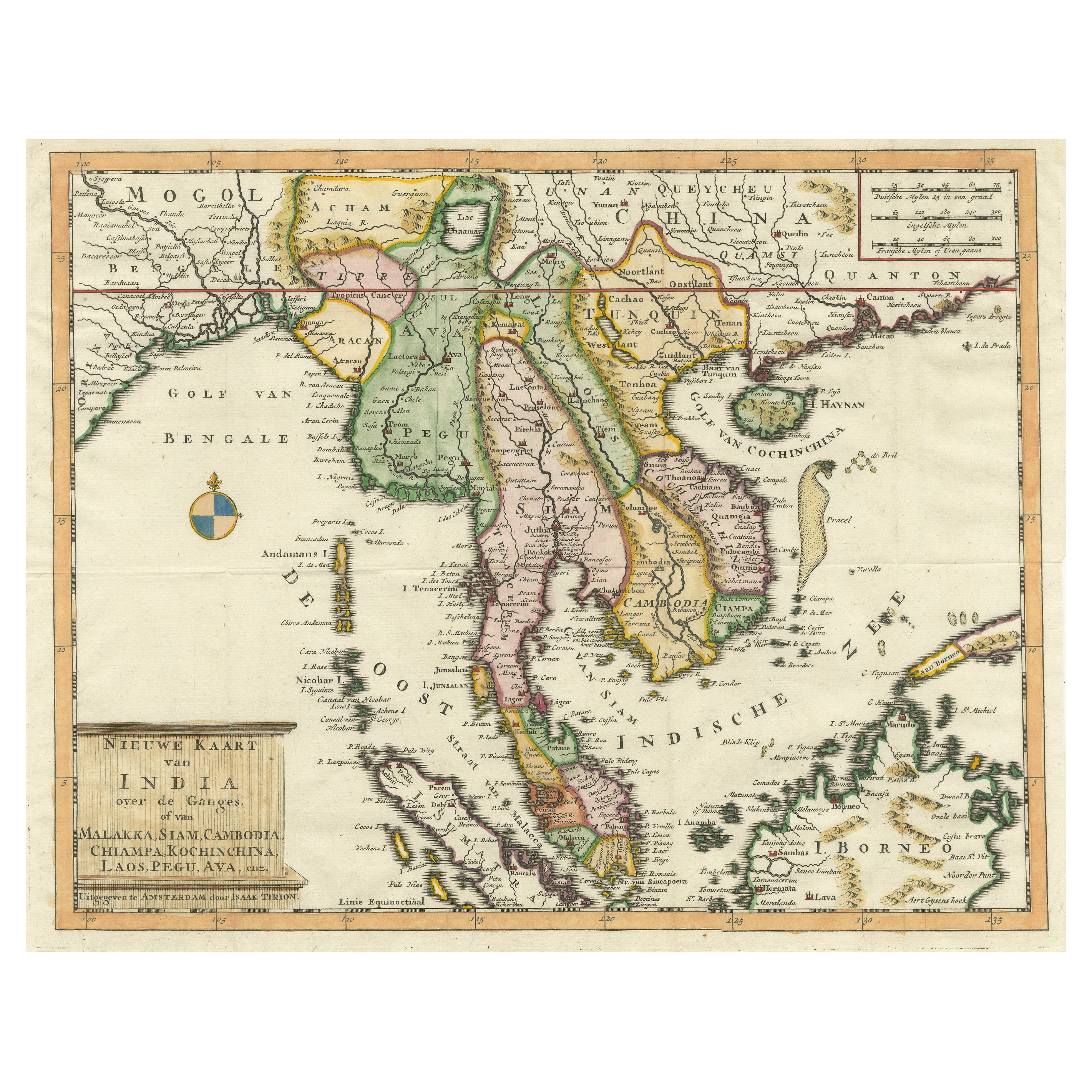
Antique Map of Indochina, the Malaysian Peninsula and Northern Sumatra
Located in Langweer, NL
Antique map titled 'Nieuwe Kaart van India over de Ganges of van Malakka, Siam, Cambodia, Chiampa, Kochinchina, Laos, Pegu, Ava, enz'. Original old map of Indochina, the Malaysian Pe...
Category
Antique Mid-18th Century Maps
Materials
Paper
$603 Sale Price
20% Off
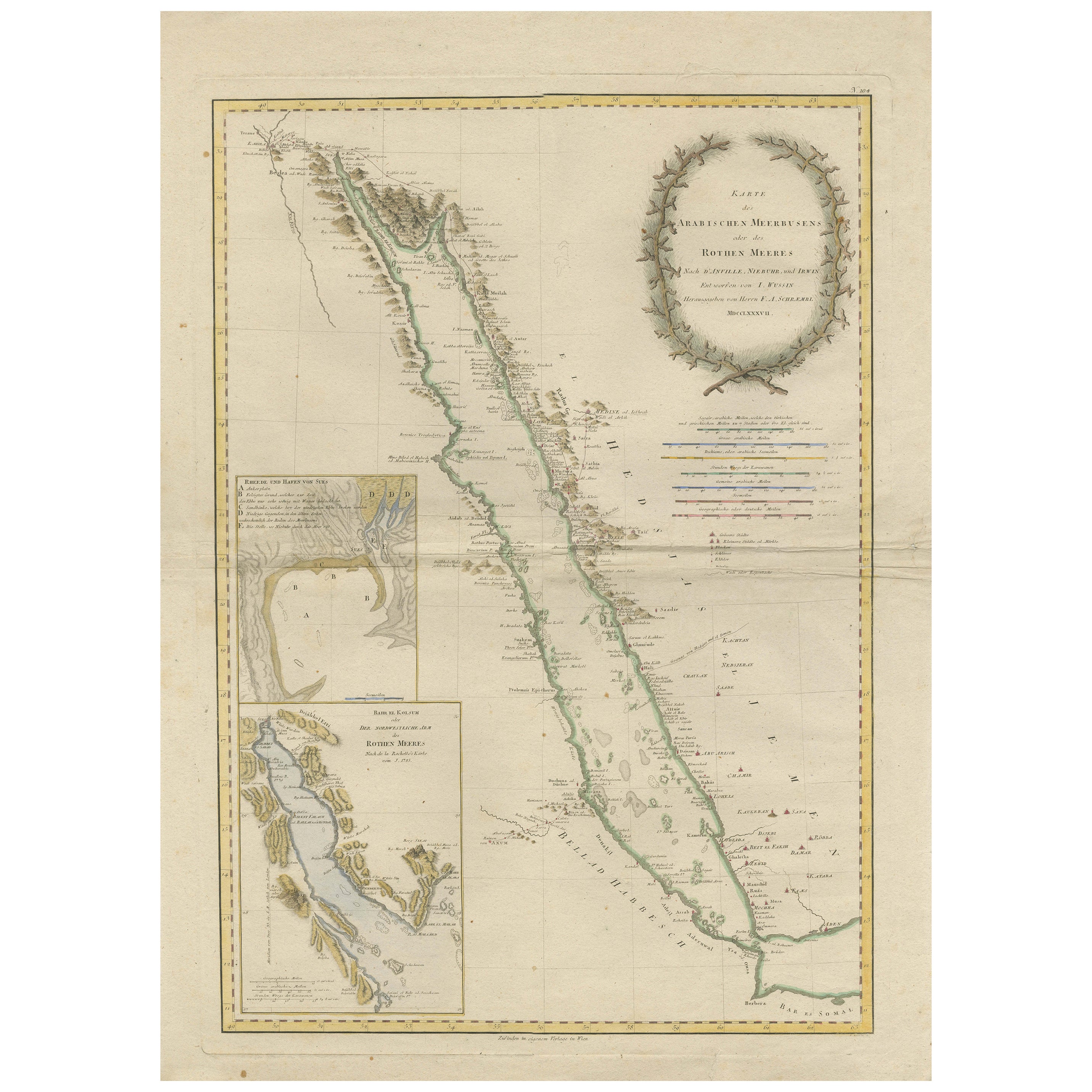
Impressive Decorative Engraved Map of the Red Sea and Arabian Peninsula, 1787
Located in Langweer, NL
This map, titled "Karte des arabischen Meerbusens oder des Rothen Meeres," is an original engraving from 1787 created by F. A. Schraembl, based on the cartographic work of d'Anville.
It is a partially colored copper engraving.
Key features and notable details of the map include:
1. The title is prominently displayed within a large, ornate cartouche, enhancing the aesthetic appeal and indicating the map's subject as the Red Sea (Rothen Meeres).
2. The map covers the Red Sea and its surrounding regions, including significant portions of the Arabian Peninsula and northeastern Africa.
3. There are two detailed inset maps:
- The first inset map shows the roadstead of the port of Suez (Rheede des Hafen von Sues).
- The second inset map depicts Bahr el Kolsum, the northwestern arm of the Red Sea, based on a map by De la Rochette from 1785.
4. Geographical Features: The map meticulously details the coastline, islands, and notable port cities along the Red Sea. The cartography highlights both natural and man-made features, with elevations and mountains represented through hachures.
5. Condition and Preservation: The map has a horizontal centerfold and is partially backed to prevent tears. The edges of the map sheet show minor holes, tears, and faint brown spots, yet it remains in overall good condition considering its age.
6. Historical Importance: This map is a valuable historical document, reflecting the cartographic knowledge of the late 18th century. It serves as a significant piece for collectors interested in antique maps, particularly those focusing on the Arabian Peninsula and maritime navigation in the Red Sea region.
The map shows the coastline of the Red Sea and the Arabian Peninsula, detailing regions and places along the western coast of Saudi Arabia and Yemen, as well as the eastern coast of Egypt and Sudan. Here are some of the most important places identified on the map:
1. Jeddah (Gedda): A major city and port on the western coast of Saudi Arabia, significant for its role as a gateway for pilgrims traveling to Mecca.
2. Mecca (Mekka): A holy city in Islam, located inland from the Red Sea, important for being the site of pilgrimage (Hajj) for Muslims.
3. Medina (Medina): Another important Islamic city, known for the Prophet's Mosque and being a key pilgrimage site.
4. Suez (Suess): Located at the northern end of the Red Sea, near the Suez Canal, it's a crucial link between the Mediterranean Sea and the Red Sea.
5. Aden: A port city in Yemen, located at the southern tip of the Arabian Peninsula, historically significant as a trading hub.
6. Mocha (Mokka): A port city in Yemen, historically known for being a major marketplace for coffee.
7. Sana'a: The capital city of Yemen, noted for its historical and cultural significance.
8. Bab el Mandeb: The strait connecting the Red Sea to the Gulf of Aden, crucial for maritime navigation.
These locations are critical due to their historical, religious, and economic significance, especially in terms of trade routes and pilgrimage sites. The map also illustrates the mountainous terrain and coastal features of the region.
The condition and preservation status, which, despite minor imperfections, is considered well-preserved for its age.
Overall, this map is a rare and valuable artifact, offering both historical insights and aesthetic appeal for collectors and enthusiasts of antique cartography.
Category
Antique 1780s Maps
Materials
Paper
$1,593 Sale Price
20% Off
Free Shipping
You May Also Like
Large Original Vintage Map of Persia / Iran, circa 1920
Located in St Annes, Lancashire
Great maps of Persia.
Unframed.
Original color.
By John Bartholomew and Co. Edinburgh Geographical Institute.
Published, circa 1920.
Free shipping.
Category
Vintage 1920s British Maps
Materials
Paper

Original Antique Map of the American State of Illinois ( Northern Part ), 1903
Located in St Annes, Lancashire
Antique map of Illinois ( Northern part )
Published By A & C Black. 1903
Original colour
Good condition
Unframed.
Free shipping
Category
Antique Early 1900s English Maps
Materials
Paper

Original Antique Map of the American State of Michigan ( Northern Part ), 1903
Located in St Annes, Lancashire
Antique map of Michigan ( Northern part )
Published By A & C Black. 1903
Original colour
Good condition
Unframed.
Free shipping
Category
Antique Early 1900s English Maps
Materials
Paper

Original Antique Map of the American State of Ohio ( Northern Part ), 1903
Located in St Annes, Lancashire
Antique map of Ohio ( Northern part )
Published By A & C Black. 1903
Original colour
Good condition
Unframed.
Free shipping
Category
Antique Early 1900s English Maps
Materials
Paper

Original Antique Map of the American State of California ( Northern Part ), 1903
Located in St Annes, Lancashire
Antique map of California ( Northern part )
Published By A & C Black. 1903
Original colour
Good condition
Unframed.
Free shipping
Category
Antique Early 1900s English Maps
Materials
Paper

Original Antique Map of the American State of Missouri ( Northern part ), 1903
Located in St Annes, Lancashire
Antique map of Missouri ( Northern Part )
Published By A & C Black. 1903
Original colour
Good condition
Unframed.
Free shipping
Category
Antique Early 1900s English Maps
Materials
Paper

More Ways To Browse
World Map Of Trade Routes
Albanian Antique
Antique Furniture Wiltshire
Antique Maps Of Israel
Framed Africa Maps
Antique Furniture Goa
Croatian Antiques
Map Of Israel
Teak Sphere
18th Century Scottish Collectibles
Map Of Mexican California
Ottoman Map
Antique Map Of Korea
Maps South East Asia
Antique Furniture Kansas City
Antique Great Lakes Map
Arnold And Son
Indianapolis Antique Furniture