Items Similar to Original Map of the Rhine River in the Holy Roman Empire by Janssonius, c.1645


Want more images or videos?
Request additional images or videos from the seller
1 of 14
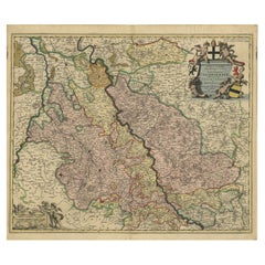
Original Map of the Rhine River in the Holy Roman Empire by Janssonius, c.1645
$1,736.15
£1,307.06
€1,470
CA$2,391.66
A$2,678.51
CHF 1,397.60
MX$32,716.88
NOK 17,781.59
SEK 16,761.28
DKK 11,189.84
About the Item
This striking original antique map, titled "Rhenus Fluviorum Europae celeberrimus," showcases the historic Rhine River region, a vital artery of European trade, culture, and history. Created by the renowned Dutch cartographer Johannes Janssonius around 1640-1650, this hand-colored copperplate engraving represents both artistry and precision in early European mapmaking. This impressive large map captures the intricate network of rivers, forests, and settlements that defined one of Europe’s most important regions.
A major focal point is the Rhine River, one of Europe’s most celebrated and storied waterways, depicted here flowing through the rich cultural landscapes of the Low Countries, the Rhineland, and beyond. This river has been a lifeline of commerce and a cradle of Western civilization for centuries. As you trace its path on the map, you can follow the historic routes that connected merchants, artists, and scholars, facilitating the exchange of goods, ideas, and innovations across the continent.
The map itself is adorned with beautiful decorative features. In the lower right, a lavishly illustrated cartouche presents allegorical river gods reclining beside the Rhine, symbolizing the wealth and bounty of the land. Above, an elegant frieze of ten coats of arms represents various regions and cities connected to the river, each held by putti (cherubs), underscoring the importance and unity of these diverse territories within the Holy Roman Empire.
For a collector, this map holds historical significance as it reflects the height of the Dutch Golden Age of cartography, when mapmakers like Janssonius were producing some of the world’s finest and most accurate maps. Janssonius, a contemporary of Blaeu, brought together the best available geographic knowledge with beautiful, intricate design, making his maps prized objects of art as well as essential tools for explorers and merchants. The 17th century was a period when maps symbolized power and prestige, so a piece of this scale and quality would likely have been owned by someone of considerable influence.
In terms of historical context, the map captures a dynamic period when regions like the Duchy of Cleves, the Electorate of Cologne, and the County of Flanders were pivotal centers of power. The Rhine itself played a central role in the economic and political developments that shaped modern Europe, including the spread of the Renaissance, the Reformation, and later the Enlightenment. Important cities visible along the Rhine’s course include Cologne, with its iconic cathedral; Mainz, a center of book printing; and Strasbourg, known for its medieval charm.
This map is not only a beautiful decorative piece but also a window into the past, inviting the viewer to explore the geographical and political landscapes of 17th-century Europe. Its age-related wear, minor foxing, and reinforcement make it clear that this map has been appreciated over the centuries, adding to its character and authenticity. Owning this piece connects you to a time when the world was being mapped, understood, and explored anew, making it a fascinating acquisition for anyone interested in European history, cartography, or art.
Tips for Framing This Map:
Frame the map using a wide, neutral-toned archival mat (or float-mount it to show the edges) and place it in a gold-leaf or dark wooden frame that matches the map’s 17th-century style. Use UV-protective museum glass to preserve the colors and reduce glare. Mount the map with acid-free, reversible materials. Optionally, add a small engraved title plaque below the frame for context. This approach highlights the map’s historical charm while ensuring long-term preservation.
- Dimensions:Height: 16.54 in (42 cm)Width: 37.21 in (94.5 cm)Depth: 0 in (0.02 mm)
- Materials and Techniques:Paper,Engraved
- Place of Origin:
- Period:Mid-17th Century
- Date of Manufacture:circa 1645
- Condition:The map is in very good condition for its age. The hand coloring remains vibrant. There is some light toning consistent with age and a vertical fold, as originally issued. Minor edge wear and a few small marginal spots, but overall fine.
- Seller Location:Langweer, NL
- Reference Number:Seller: BG-13951 1stDibs: LU3054342338362
About the Seller
5.0
Recognized Seller
These prestigious sellers are industry leaders and represent the highest echelon for item quality and design.
Platinum Seller
Premium sellers with a 4.7+ rating and 24-hour response times
Established in 2009
1stDibs seller since 2017
2,533 sales on 1stDibs
Typical response time: <1 hour
- ShippingRetrieving quote...Shipping from: Langweer, Netherlands
- Return Policy
Authenticity Guarantee
In the unlikely event there’s an issue with an item’s authenticity, contact us within 1 year for a full refund. DetailsMoney-Back Guarantee
If your item is not as described, is damaged in transit, or does not arrive, contact us within 7 days for a full refund. Details24-Hour Cancellation
You have a 24-hour grace period in which to reconsider your purchase, with no questions asked.Vetted Professional Sellers
Our world-class sellers must adhere to strict standards for service and quality, maintaining the integrity of our listings.Price-Match Guarantee
If you find that a seller listed the same item for a lower price elsewhere, we’ll match it.Trusted Global Delivery
Our best-in-class carrier network provides specialized shipping options worldwide, including custom delivery.More From This Seller
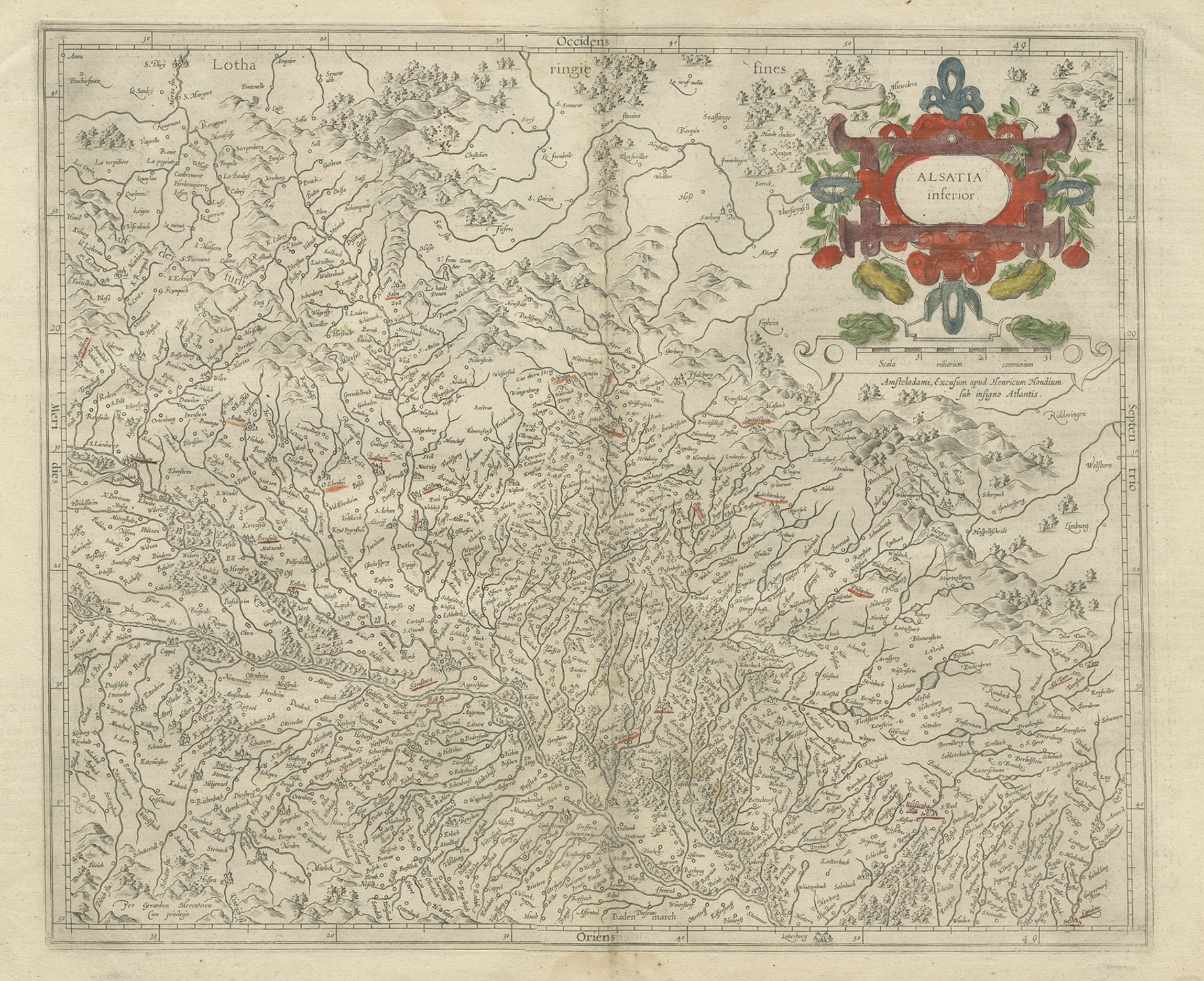
View AllAntique Map of the Lower Alsace Region of France by Mapmaker Hondius, c.1630
Located in Langweer, NL
Antique map titled 'Alsatia Inferior'. Original antique map of the northern Alsace (Elzas) region of France. The map is centered on the course of the Rhine River, with Strasbourg at ...
Category
Antique 17th Century Maps
Materials
Paper
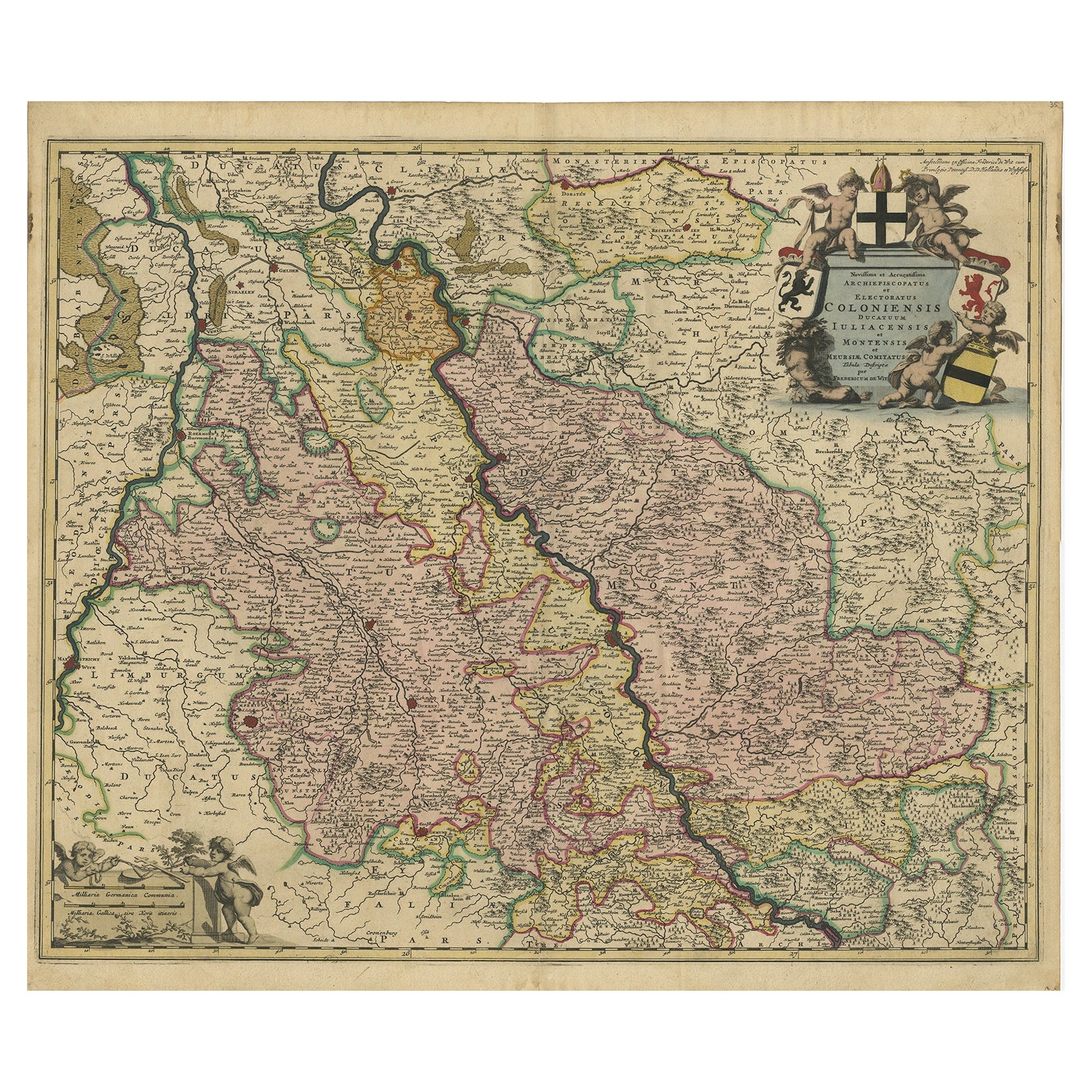
Rhine Splendor: Antique Map of the Lower Rhine Region, circa 1680
Located in Langweer, NL
The antique map titled 'Novissima et Accuratissima Archiepiscopatus et Electoratus Coloniensis Ducatuum Iuliancensis et Montensis et Meursiae Comitatus' is a handsome and detailed ma...
Category
Antique 1680s Maps
Materials
Paper
$907 Sale Price
20% Off
Free Shipping
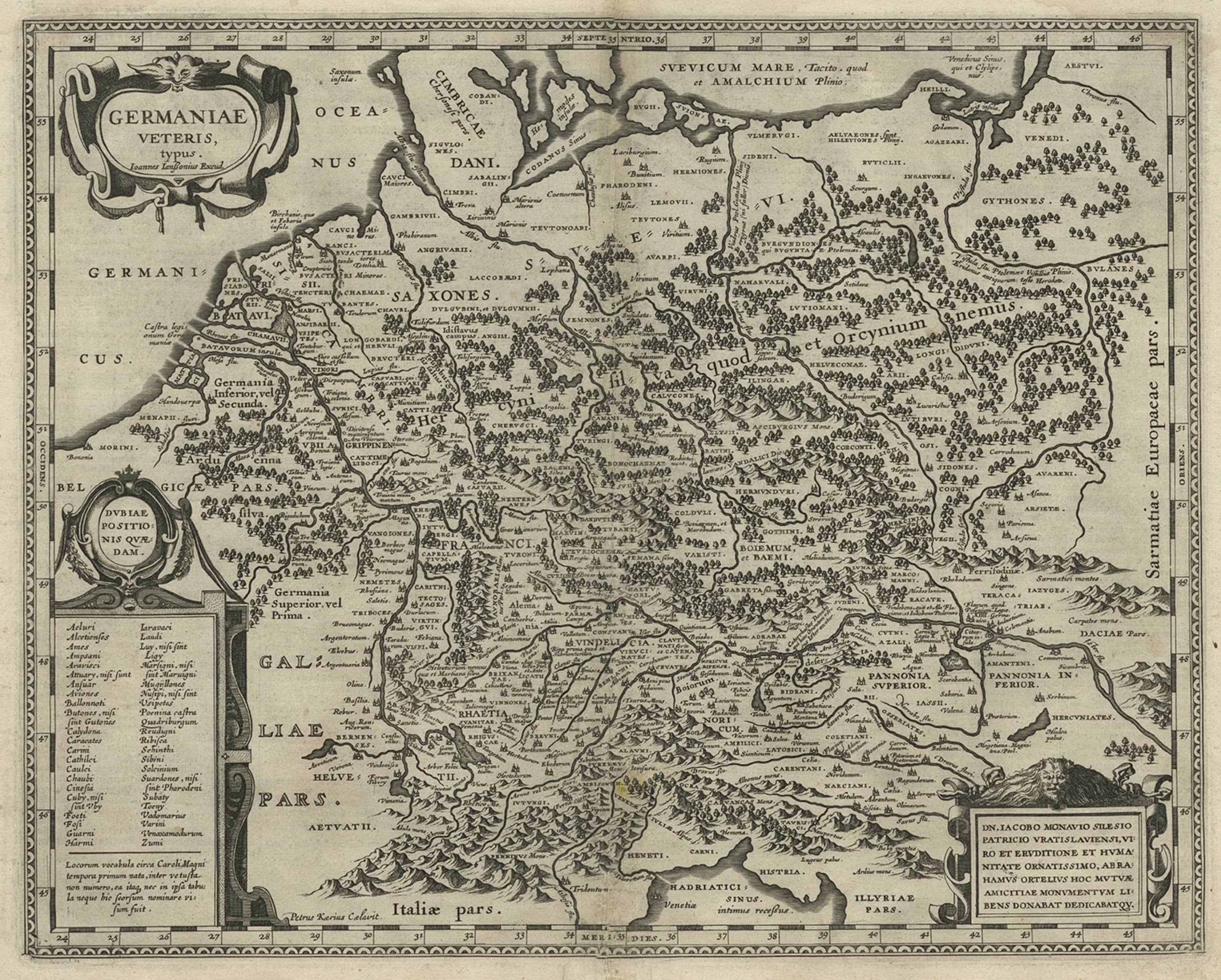
Antique Map of Germany of German in Roman Times, c.1660
Located in Langweer, NL
Antique map Germany titled 'Germaniae Veteris Typus'. Antique map probably by Blaeu or based on an earlier state by W. Blaeu.
Minor differences shown in the cartouches. Top left ha...
Category
Antique 17th Century Maps
Materials
Paper

$803 Sale Price
20% Off
Old Map of the Western Part of Central Europe, c.1680
Located in Langweer, NL
Antique map titled 'Carta nova accurate del Passagio et strada dalli Paesi Bassi'. Old map of the western portion of Central Europe. Oriented to the Northeast.
Artists and Engrav...
Category
Antique 17th Century Maps
Materials
Paper

$354 Sale Price
20% Off
Original Rare Antique Map of the Ancient German Empire in Northern Europe, c1650
Located in Langweer, NL
Antique map titled 'Germaniae Veteris typus.'
Map of the ancient German Empire in Northern Europe, based upon an earlier map by Ortelius. Extends fr...
Category
Antique 1650s Maps
Materials
Paper
$623 Sale Price
20% Off
Antique Map of the Rhine and Moselle River Region in Germany and France, c.1680
Located in Langweer, NL
Antique map titled 'Tabula Geographica qui Pars Meridionalis sive Superior Rheni, Mosae et Mosellae (..).'
Detailed map of the Rhine and Moselle River regions and contigous parts...
Category
Antique 17th Century Maps
Materials
Paper

$519 Sale Price
20% Off
You May Also Like
West Germany: Original Hand Colored 17th Century Map by Johannes Janssonius
By Johannes Janssonius
Located in Alamo, CA
An original hand colored copperplate engraved map entitled in Latin "Archiepiscopatus Maghdeburgensis et Anhaltinus Ducatus cum terris adjacentibus", published in Amsterdam in 1640 i...
Category
Mid-17th Century Old Masters More Prints
Materials
Engraving

1640 Joan Bleau Map Entitled"Diocecese de rheims et le pais de rethel, " Eic.a011
Located in Norton, MA
1640 Joan Bleau map entitled
"Diocecese de rheims et le pais de rethel,"
Ric.a011
OAN BLAEU
Diocecese de Rheims, et le pais de Rethel.
Handcolored engraving, c.1640.
...
Category
Antique 17th Century Dutch Maps
Materials
Paper

1657 Janssonius Map of Vermandois and Cappelle, Ric. A-004
Located in Norton, MA
1657 Janssonius map of
Vermandois and Cappelle
Ric.a004
Description: Antique map of France titled 'Descriptio Veromanduorum - Gouvernement de la Cappelle'. Two detailed maps o...
Category
Antique 17th Century Unknown Maps
Materials
Paper

1640 Willem Blaeu Map Entitled "Contado di molise et principato vltra, " Ric.a003
By Willem Blaeu
Located in Norton, MA
1640 Willem Blaeu map entitled
"Contado di molise et principato vltra,"
Colored
Ric. a003
Measures: 38 x 49.6 cm and wide margins
DBLAEU.
Cou...
Category
Antique 17th Century Dutch Maps
Materials
Paper

Ancient Map - Macedonia - Etching by Johannes Janssonius - 1650s
By Johannes Janssonius
Located in Roma, IT
Macedonia is an ancient map realized in 1650 by Johannes Janssonius (1588-1664).
The Map is Hand-colored etching, with coeval watercoloring.
Good condit...
Category
1650s Modern Figurative Prints
Materials
Etching

A Hand Colored 17th Century Janssonius Map of Prussia: Poland, N. Germany, etc.
By Johannes Janssonius
Located in Alamo, CA
An attractive hand-colored copperplate engraved 17th century map of Prussia entitled "Prussia Accurate Descripta a Gasparo Henneberg Erlichensi", published in Amsterdam by Joannes Janssonius in 1664. This very detailed map from the golden age of Dutch cartography includes present-day Poland, Latvia, Lithuania, Estonia and portions of Germany. This highly detailed map is embellished by three ornate pink, red, mint green and gold...
Category
Mid-17th Century Old Masters Landscape Prints
Materials
Engraving

More Ways To Browse
Antique Engraving Tools
Wooden Recliner
Cherub Plaque
Antique Cathedral Glass
Cherub Charm
Antique Glass Floats
Wooden Cradle
Gold Charm Connector
17th Century Plaque
Putti Plaque
Coat Of Arms Plaque
Medieval Plaque
Cherub Putti Wooden
Strasbourg Cathedral
Elios Chair
Plata Lappas
Red Retro Dining Set
Antique Bouquet