Items Similar to Original Steel Engraved Map of French Colonies in America, 1854
Want more images or videos?
Request additional images or videos from the seller
1 of 9
Original Steel Engraved Map of French Colonies in America, 1854
$302.45
$378.0620% Off
£226.71
£283.3820% Off
€256
€32020% Off
CA$415.52
CA$519.4020% Off
A$463.89
A$579.8620% Off
CHF 243.07
CHF 303.8420% Off
MX$5,678.42
MX$7,098.0320% Off
NOK 3,086.98
NOK 3,858.7320% Off
SEK 2,910.63
SEK 3,638.2920% Off
DKK 1,948.77
DKK 2,435.9620% Off
About the Item
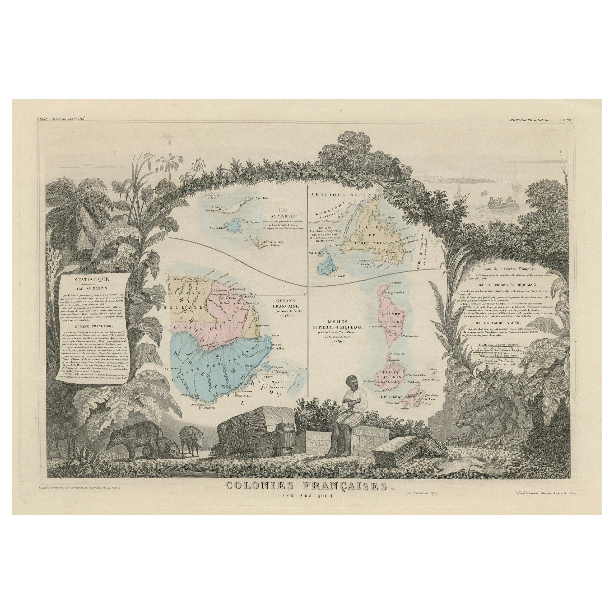
Antique map titled 'Colonies Francaises (en Amerique)'. Detailed map bordered by vignettes showing local animals, produce and activities of the various French Colonies in America. This map originates from ‘Atlas National de la France Illustré’. Published by A. Combette, Paris, 1854.
On the antique map "Colonies Françaises (en Amérique)," several areas stand out as particularly special due to their historical significance, natural resources, or cultural prominence. Here are some notable regions highlighted on the map:
1. **French West Indies**: This includes the islands of Martinique, Guadeloupe, Saint Martin, Saint Barthélemy, and others. Known for their sugar plantations, rum production, and vibrant Creole culture, these islands were key components of the French colonial empire in the Caribbean.
2. **French Guiana**: Located on the northeastern coast of South America, French Guiana is known for its dense rainforests, diverse wildlife, and infamous Devil's Island, a former penal colony.
3. **Louisiana**: While much of Louisiana had been sold to the United States in the Louisiana Purchase of 1803, French influence and culture remained strong in the region, particularly in New Orleans and surrounding areas.
4. **Québec**: This Canadian province was a significant French colonial settlement and retains a strong French cultural identity to this day. Québec City, founded in 1608, is one of the oldest European settlements in North America.
5. **Haiti**: The western part of the island of Hispaniola, Haiti was a French colony known for its lucrative sugar plantations worked by enslaved Africans. It became the site of the only successful slave revolt in history, leading to its independence from France in 1804.
6. **French Guyana**: This territory, located on the northeastern coast of South America, was a site of French penal colonies and remains an overseas department of France today.
These areas are highlighted not only for their geographic significance but also for their historical, cultural, and economic importance within the French colonial empire in the Americas. The vignettes around the map's border likely depict scenes and products specific to these regions, further emphasizing their uniqueness and importance.
This antique map titled "Colonies Françaises (en Amérique)" holds several characteristics that make it special:
1. **Detailed Representation**: The map offers a detailed depiction of the French colonies in America during the mid-19th century. This level of detail provides insights into the geographic extent and layout of these colonies during this historical period.
2. **Vignettes**: The inclusion of vignettes around the map's border showcasing local animals, produce, and activities of the various French colonies adds both decorative and informative elements. These vignettes provide a glimpse into the cultural and natural diversity of the regions depicted on the map.
3. **Historical Context**: Produced in 1854, the map provides a snapshot of the French colonial presence in America during a time when European powers were actively colonizing and competing for territories in the New World. Understanding the historical context surrounding the map's creation enriches its significance.
4. **Publication Details**: The map originates from the "Atlas National de la France Illustré," published by A. Combette in Paris. The association with this renowned atlas adds to the map's provenance and prestige.
5. **Artistic Value**: Beyond its informational content, the map likely possesses artistic value through its design, typography, and decorative elements. Antique maps of this nature often appeal to collectors and enthusiasts for their aesthetic qualities.
Overall, the combination of historical, geographical, and artistic elements makes this antique map a special and valuable piece, offering not only cartographic information but also insights into the cultural and natural landscapes of the French colonies in America during the 19th century.
- Dimensions:Height: 13.12 in (33.3 cm)Width: 18.71 in (47.5 cm)Depth: 0.02 in (0.5 mm)
- Materials and Techniques:
- Period:
- Date of Manufacture:1854
- Condition:General age-related toning. Minor wear and soiling, light pencil notation below title. Blank verso. Please study image carefully.
- Seller Location:Langweer, NL
- Reference Number:Seller: BG-13528-21stDibs: LU3054338412012
About the Seller
5.0
Recognized Seller
These prestigious sellers are industry leaders and represent the highest echelon for item quality and design.
Platinum Seller
Premium sellers with a 4.7+ rating and 24-hour response times
Established in 2009
1stDibs seller since 2017
2,513 sales on 1stDibs
Typical response time: <1 hour
- ShippingRetrieving quote...Shipping from: Langweer, Netherlands
- Return Policy
Authenticity Guarantee
In the unlikely event there’s an issue with an item’s authenticity, contact us within 1 year for a full refund. DetailsMoney-Back Guarantee
If your item is not as described, is damaged in transit, or does not arrive, contact us within 7 days for a full refund. Details24-Hour Cancellation
You have a 24-hour grace period in which to reconsider your purchase, with no questions asked.Vetted Professional Sellers
Our world-class sellers must adhere to strict standards for service and quality, maintaining the integrity of our listings.Price-Match Guarantee
If you find that a seller listed the same item for a lower price elsewhere, we’ll match it.Trusted Global Delivery
Our best-in-class carrier network provides specialized shipping options worldwide, including custom delivery.More From This Seller
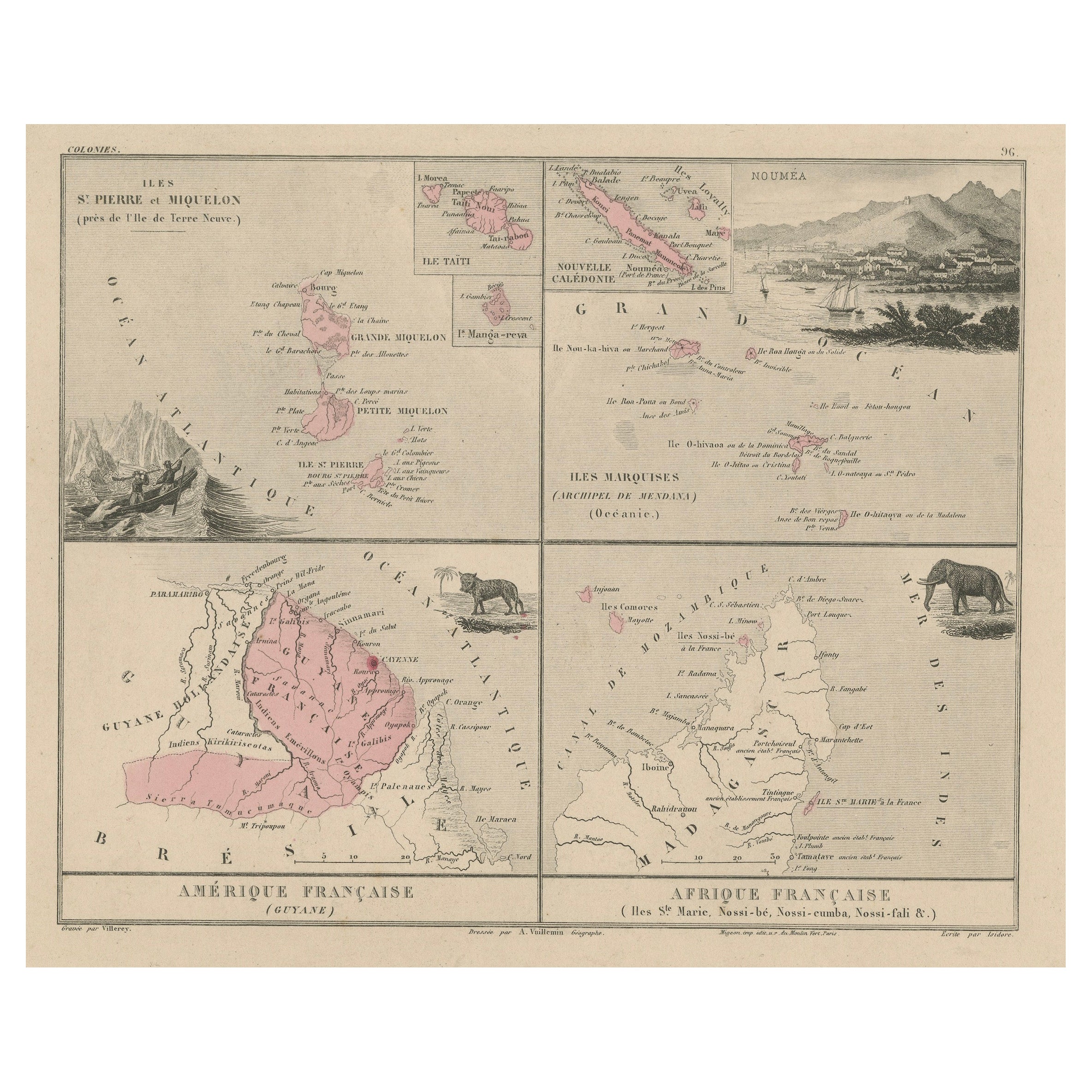
View AllMap of French Colonies in the Americas: St. Martin, French Guiana and St. Pierre
Located in Langweer, NL
This is an intricately detailed map from 1852 titled *Colonies Françaises en Amérique*, depicting several key French colonies in the Americas.
The map focuses on regions such as Fr...
Category
Antique 1850s Maps
Materials
Paper
$179 Sale Price
20% Off
Antique Map of French Colonies – La France, 19th Century
Located in Langweer, NL
Title: Antique Map of French Colonies – La France, 19th Century
Description: This antique 19th-century map, titled La France, presents a detailed depiction of France’s overseas c...
Category
Antique 1870s Maps
Materials
Paper

Antique Map of the French Colony Guadeloupe by V. Levasseur, 1854
By Victor Levasseur
Located in Langweer, NL
Antique map titled 'Colonies Françaises (en Amerique). Detailed map of the island of Guadeloupe in the Caribbean Sea, with decorative frame containing views of the island. This map o...
Category
Antique Mid-19th Century Maps
Materials
Paper
$189 Sale Price
20% Off
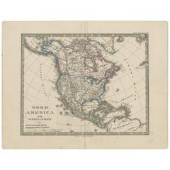
Antique Map of North America and the West Indies by Stieler, circa 1865
Located in Langweer, NL
Antique map titled 'Nord-America und West-Indien'. Old map of North America and the West Indies. This map originates from Stieler's 'Schul-Atlas'.
Category
Antique Mid-19th Century Maps
Materials
Paper
$113 Sale Price
20% Off
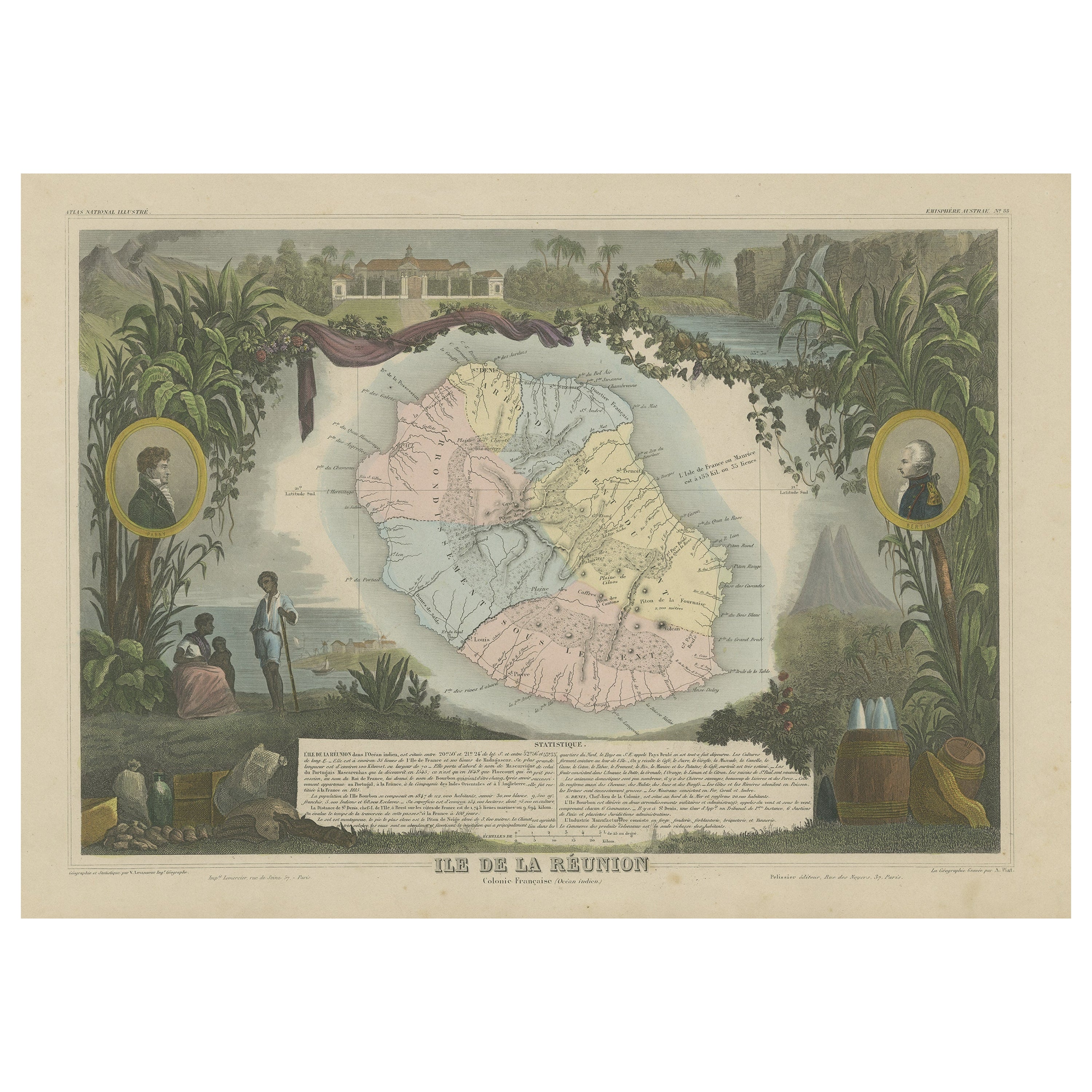
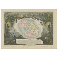
Antique Map of Bourbon, or Reunion, Colony of France
Located in Langweer, NL
Original antique map titled 'Ile de la Réunion'. This is a fascinating map of the French department of Ile. Bourbon or Reunion. Bourbon, or Reunion, is a volcanic island off the coas...
Category
Antique Mid-19th Century Maps
Materials
Paper
$321 Sale Price
20% Off
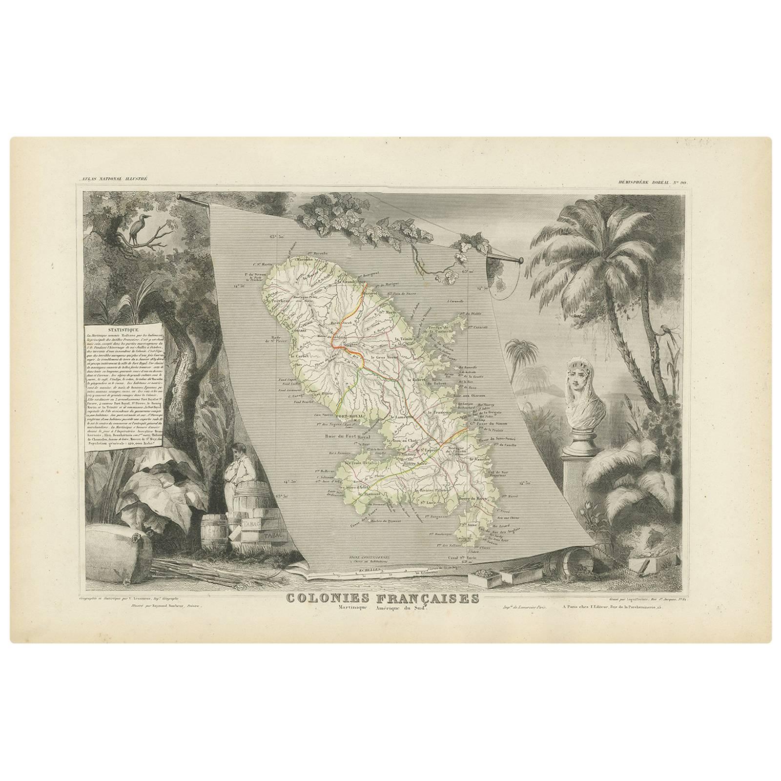
Antique Map of the French Colony Martinique by V. Levasseur, 1854
By Victor Levasseur
Located in Langweer, NL
Antique map titled 'Colonies Françaises. Martinique, Amérique du Sud'. This map originates from ‘Atlas National de la France Illustré’. Published by A. Combette, Paris, 1854.
Category
Antique Mid-19th Century Maps
Materials
Paper

$189 Sale Price
20% Off
You May Also Like
Map Colonies Francaises Martinique, 1845
Located in BUNGAY, SUFFOLK
Colonies Francaises, Martinique, Amerique DU SUD
Geographie et Statistique par V.Levasseur. Ing'r Geographe.
Illustre par Raymond Bonheur, peintre.
Grave par Laguihermie, Rue St...
Category
Antique 19th Century French Maps
Materials
Paper

Original Antique Map of United States, Grattan and Gilbert, 1843
Located in St Annes, Lancashire
Great map of United States
Drawn and engraved by Archer
Published by Grattan and Gilbert. 1843
Original colour
Unframed.
Category
Antique 1840s English Maps
Materials
Paper

English Engraved Hand Colored Map of the North Eastern United States, circa 1817
Located in Charleston, SC
English copper engraved hand colored map of the North Eastern United States matted under glass in a gilt frame, Early 19th Century. Drawn and Engraved for Thomson's New General Atlas...
Category
Antique 1810s English George III Maps
Materials
Glass, Giltwood, Paint, Paper

Original Antique Map of The United States of America by Dower, circa 1835
Located in St Annes, Lancashire
Nice map of the USA
Drawn and engraved by J.Dower
Published by Orr & Smith. C.1835
Unframed.
Free shipping
Category
Antique 1830s English Maps
Materials
Paper

1846 "North America" Map, Engraved by I. Dower
Located in Colorado Springs, CO
Presented is an original 1846 map of “North America.” The map was drawn and engraved by I. Dower and published in London by Orr & Company. The map depicts North America, to include G...
Category
Antique 1840s English Victorian Maps
Materials
Paper

Original Antique Map of Central America / Florida, Arrowsmith, 1820
Located in St Annes, Lancashire
Great map of Central America.
Drawn under the direction of Arrowsmith.
Copper-plate engraving.
Published by Longman, Hurst, Rees, Orme and Brown, 1820
Unframed.
Category
Antique 1820s English Maps
Materials
Paper

More Ways To Browse
African American Antique
Used Furniture In New Orleans
Original American Colonial Furniture
African American 19th Century
Antique Plantation Furniture
Antique Rum
Antique Rummer
Creole Furniture
Vintage Wood Table With Glass Top
19th Century Square Table
Galle Chairs
Large Chinese Rug
1940s Vintage French Art Deco
20th Century Spanish Table
Antonio Bellini
Retro Fiberglass Furniture
Shipping Crate
Antique Oushak Carpets