Items Similar to Plan of the Dutch Fort in Formosa – Antique French Jesuit Engraving, ca.1790
Want more images or videos?
Request additional images or videos from the seller
1 of 10
Plan of the Dutch Fort in Formosa – Antique French Jesuit Engraving, ca.1790
$414.83
£308.84
€350
CA$571.58
A$636.45
CHF 336.57
MX$7,745.20
NOK 4,242.53
SEK 3,997.09
DKK 2,664.39
About the Item
Plan of the Dutch Fort in Formosa – Antique French Jesuit Engraving by Portier, c.1790
This antique French engraving by Portier, produced around 1790, shows a detailed plan of the Dutch fort on the island of Formosa (modern Taiwan), identified in the French title as “Plan du Fort de Hollande à l’Ile Formose.” The Chinese called this fort “Ngan-ping-Tching,” and the plan is noted as being based on surveys ordered by the Emperor of China.
The engraving presents two geometric fortifications in precise measured outline, drawn at a scale of 20 toises per division, with a note explaining that 20 leagues equal one degree of latitude, corresponding to 5,000 toises. The star-shaped bastion layout, with angled walls and projecting defensive points, reflects European military architecture of the 17th century, introduced to Asia during the Dutch colonial period.
This fort is almost certainly Fort Zeelandia in Tainan, built by the Dutch East India Company between 1624 and 1634. The stronghold was a key base for Dutch trade and military operations in the region until 1662, when it was surrendered to Chinese forces led by Koxinga (Zheng Chenggong). Its depiction here reflects both historical interest and the Jesuit mission to accurately document geographic and architectural features of strategic sites.
The clean, uncluttered linework and precise proportions are typical of Enlightenment-era French surveying engravings, intended for both scientific accuracy and publication in missionary or travel accounts.
Condition report: Good condition with a strong plate mark and crisp impression. Minor toning and a few faint foxing spots in the margins. A light horizontal fold as issued. Paper remains strong and stable.
Framing tips: Best displayed in a black or walnut frame with an off-white archival mat. A thin gold inner slip could enhance the historic military cartography aesthetic.
Technique: Engraving
Maker: Portier, France, c.1790
- Dimensions:Height: 5.83 in (14.8 cm)Width: 7.88 in (20 cm)Depth: 0.01 in (0.2 mm)
- Materials and Techniques:Paper,Engraved
- Place of Origin:
- Period:
- Date of Manufacture:circa 1790
- Condition:Condition report: Good condition with a strong plate mark and crisp impression. Minor toning and a few faint foxing spots in the margins. A light horizontal fold as issued. Paper remains strong and stable.
- Seller Location:Langweer, NL
- Reference Number:Seller: BG-14078-181stDibs: LU3054346211312
About the Seller
5.0
Recognized Seller
These prestigious sellers are industry leaders and represent the highest echelon for item quality and design.
Platinum Seller
Premium sellers with a 4.7+ rating and 24-hour response times
Established in 2009
1stDibs seller since 2017
2,569 sales on 1stDibs
Typical response time: <1 hour
- ShippingRetrieving quote...Shipping from: Langweer, Netherlands
- Return Policy
Authenticity Guarantee
In the unlikely event there’s an issue with an item’s authenticity, contact us within 1 year for a full refund. DetailsMoney-Back Guarantee
If your item is not as described, is damaged in transit, or does not arrive, contact us within 7 days for a full refund. Details24-Hour Cancellation
You have a 24-hour grace period in which to reconsider your purchase, with no questions asked.Vetted Professional Sellers
Our world-class sellers must adhere to strict standards for service and quality, maintaining the integrity of our listings.Price-Match Guarantee
If you find that a seller listed the same item for a lower price elsewhere, we’ll match it.Trusted Global Delivery
Our best-in-class carrier network provides specialized shipping options worldwide, including custom delivery.More From This Seller
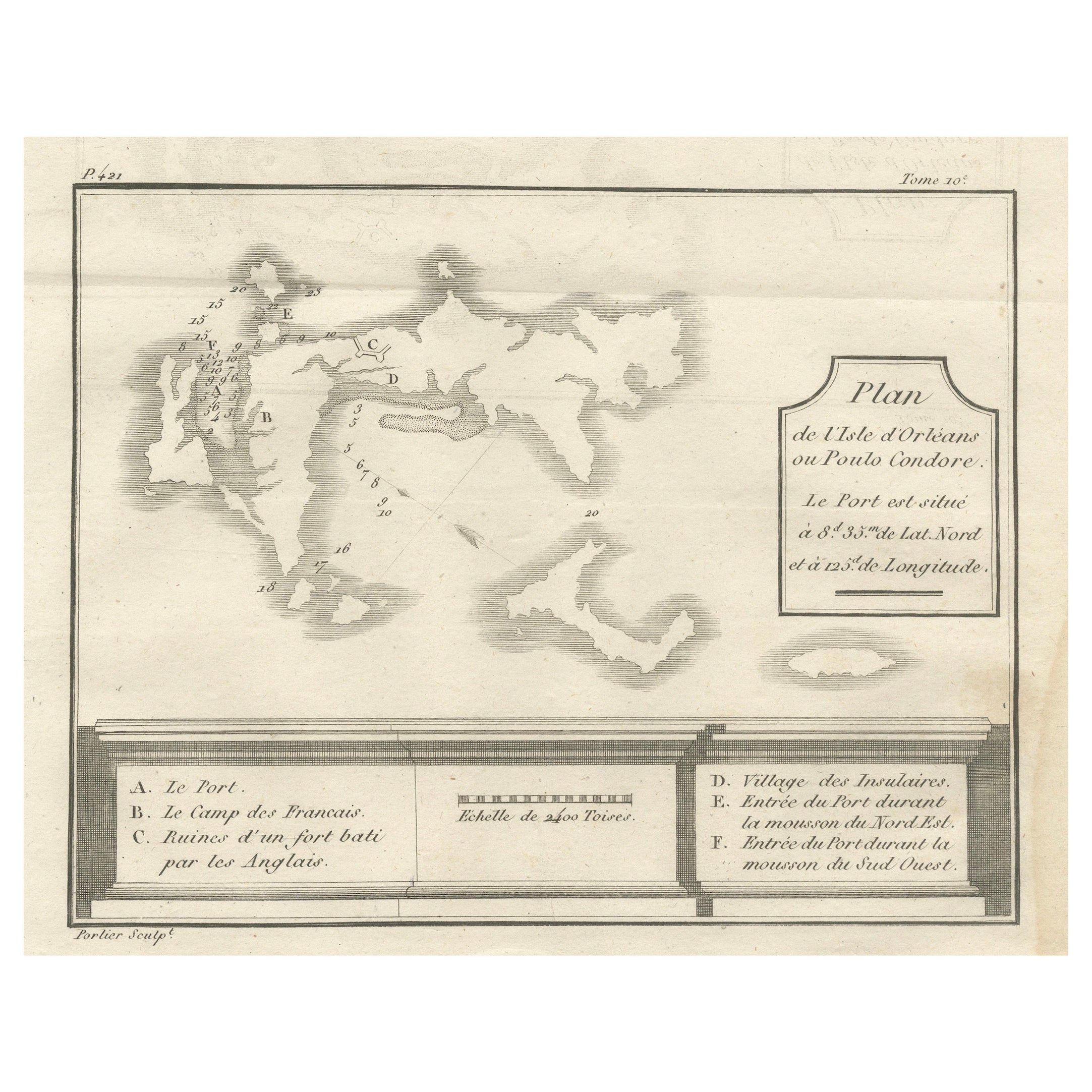
View AllPlan of Poulo Condore (Côn Sơn Island) – Antique French Engraving, ca.1790
Located in Langweer, NL
Plan of Poulo Condore (Côn Sơn Island) – Antique French Engraving by Portier, c.1790
This antique French engraving, created by Portier around 1790, presents a detailed plan of Poulo...
Category
Antique Late 18th Century French Maps
Materials
Paper
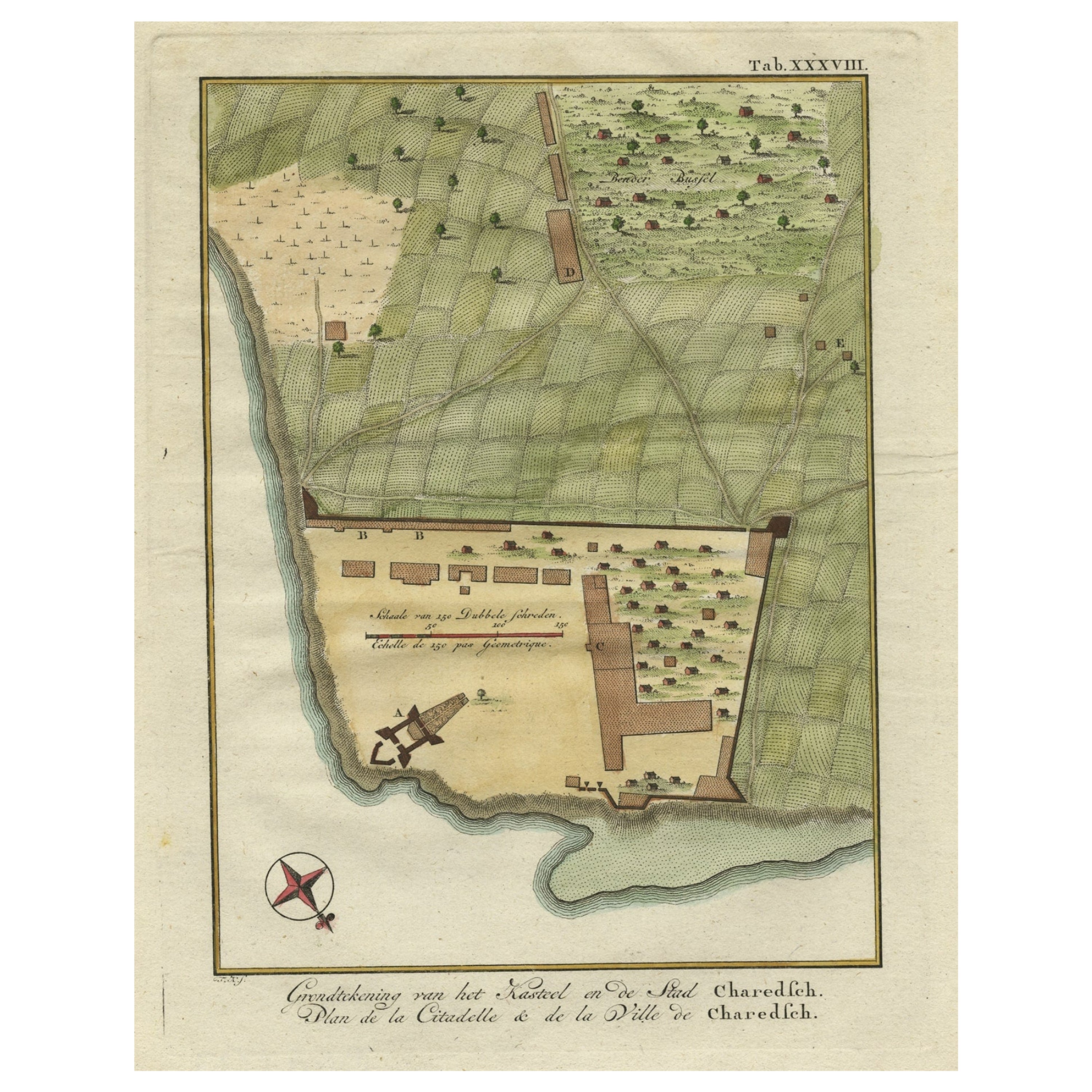
Original Antique Plan of the Fortress of Charedsch in Persia or Iran, ca.1780
Located in Langweer, NL
Antique map, titled: 'Plan de la Citadelle de la Ville de Charedsch.'
Plan of the fortress of Charedsch, Iran / Persia. This original antique print originates from 'Reize naar Ar...
Category
Antique 1780s Maps
Materials
Paper

$305 Sale Price
20% Off
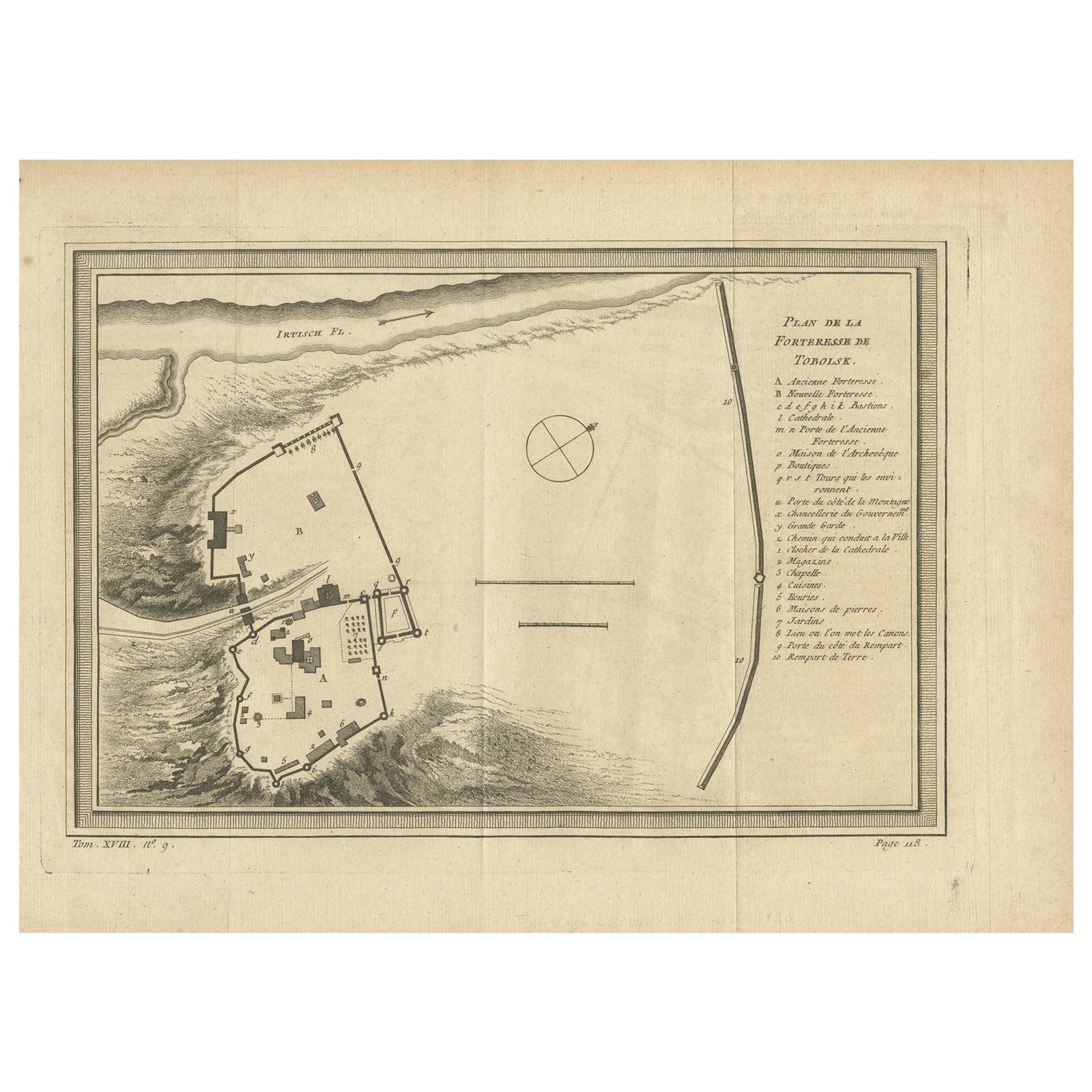
Antique Plan of the Fortress of Tobolsk by Bellin '1768'
Located in Langweer, NL
Antique map titled 'Plan de la Forteresse de Tobolsk'. Original plan of the Fortress of Tobolsk, a town in Tyumen Oblast, Russia. Engraved by J.N. Bellin ...
Category
Antique Mid-18th Century Maps
Materials
Paper
$190 Sale Price
20% Off
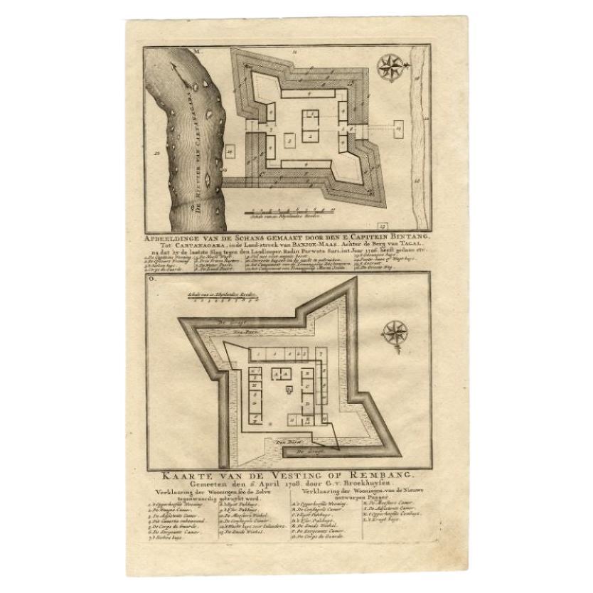
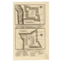
Antique Map of the Fortress of Captain E. Bintang by Valentijn, 1726
Located in Langweer, NL
Antique print titled 'Kaarte van de Schans gemaakt door den E. Capitein Bintang. Kaarte van de Vesting op Rembang.' A plan of the fort constructed by the Captain E. Bintang, in the B...
Category
Antique 18th Century Maps
Materials
Paper
$88 Sale Price
20% Off
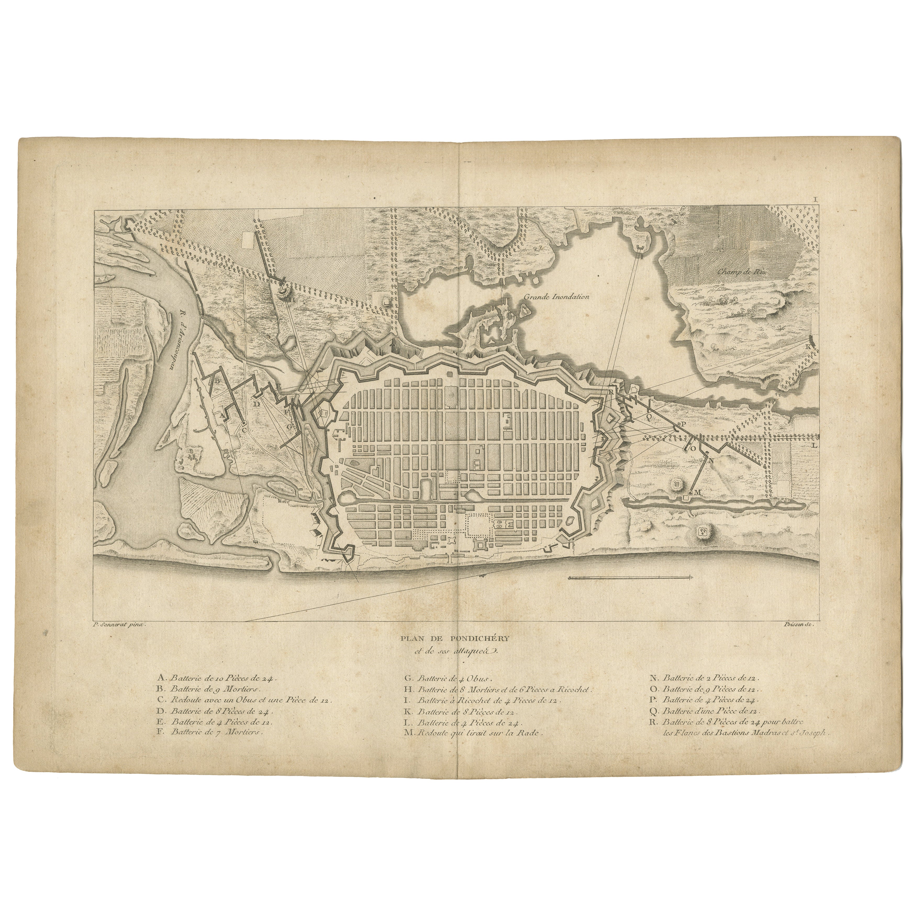
Plan of Pondicherry Fortifications and Attacks, France, c.1750
Located in Langweer, NL
Plan of Pondicherry Fortifications and Attacks, France, c.1750
This finely engraved map depicts the fortified city of Pondicherry, titled "Plan de Pondichéry et de ses attaques." It...
Category
Antique Mid-18th Century French Maps
Materials
Paper
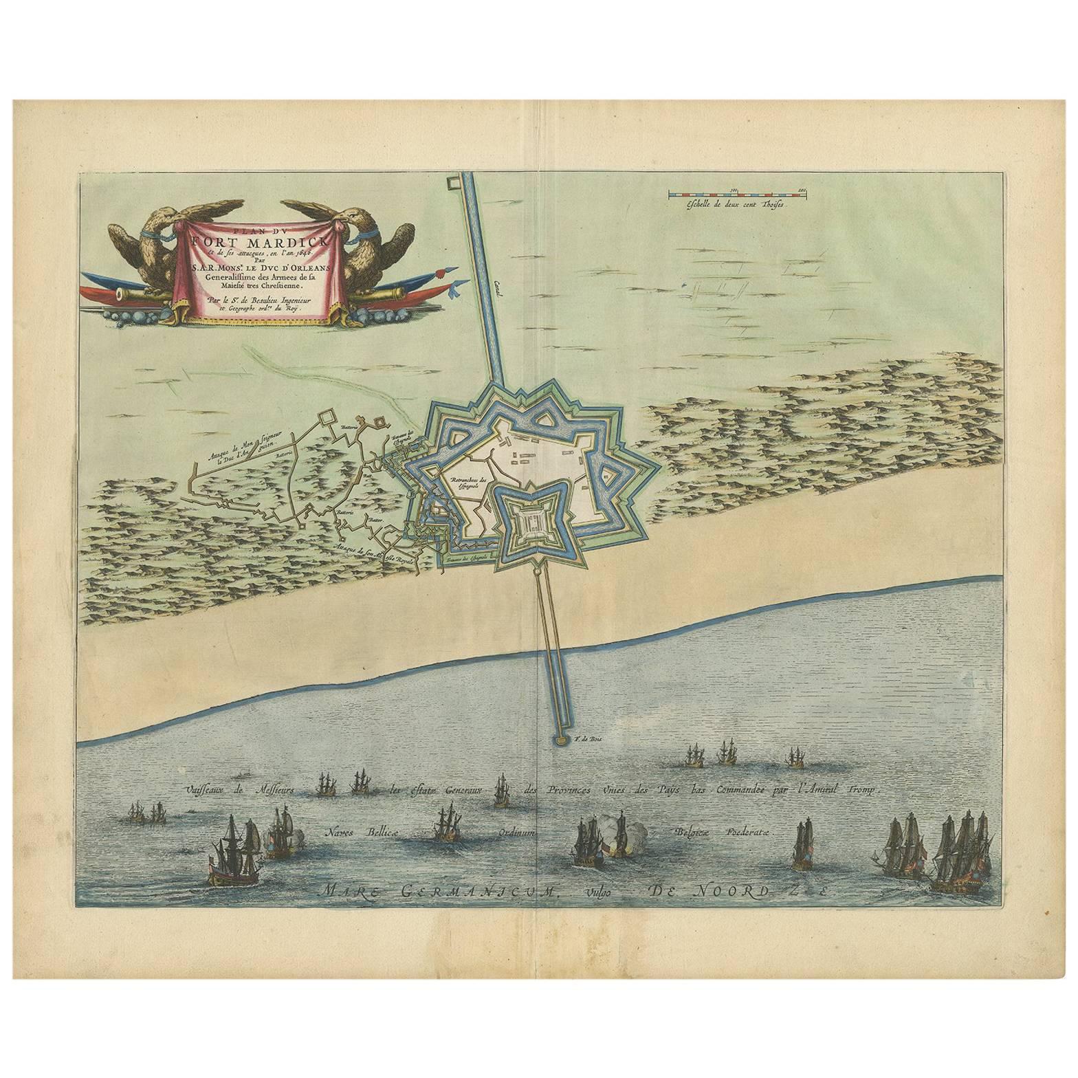
Antique Plan of Fort Mardyck Mardijk, France by S. Beaulieu, 1649
Located in Langweer, NL
Plan of Fort Mardyck (Fort Mardijk) and surroundings by Sébastian de Pontault Beaulieu. Mardyck is a former commune in the Nord department in northern France. It is an associated com...
Category
Antique Mid-17th Century Maps
Materials
Paper

$510 Sale Price
20% Off
You May Also Like
Plan of Port Siagi - Etching by Joseph Roux - 1795
Located in Roma, IT
Plan of Port Siagi is al colored etching realized by Joseph Roux in 1795.
The title at the top " Plan du Port Siagi"
Passepartout included: 34 x 49
The artwork is hand water-color...
Category
1790s Modern Figurative Prints
Materials
Etching

Original Antique Map or City Plan of Geneva, Switzerland. Circa 1835
Located in St Annes, Lancashire
Nice map of Geneva
Drawn and engraved by J.Dower
Published by Orr & Smith. C.1835
Unframed.
Free shipping
Category
Antique 1830s English Maps
Materials
Paper

Plan of the Park, Garden and Plantations of Goodwood, 18th century engraving
By Colen Campbell
Located in Melbourne, Victoria
Plan of the Park, Garden and Plantations of Goodwood in Sussex the Seat of his Grace the Duke of Richmond and Lenox &c
Copper-line engraving with later hand-colouring by Hendrik Hul...
Category
18th Century English School Landscape Prints
Materials
Engraving
Map - Etching by Nicola Fiorillo - 18th Century
Located in Roma, IT
Map from "Antiquities of Herculaneum" is an etching on paper realized by Nicola Fiorillo in the 18th Century.
Signed on the plate.
Good conditions with some folding and foxing.
Th...
Category
18th Century Old Masters Figurative Prints
Materials
Etching
17th-18th Century Siege of Graves Mapping Engraving By Willian III
Located in Kingston, NY
RARE French 17th-18th Century Enhanced Siege of Graves Mapping Engraving BY William III, also widely known as William of Orange,
The Siege of Grave in Dutch Brabant started by Monsie...
Category
Antique 17th Century French Prints
Materials
Paper

Architectural Roman Map - Etching by Vincenzo Scarpati - 18th Century
Located in Roma, IT
Architectural Roman Map from "Antiquities of Herculaneum" is an etching on paper realized by Vincenzo Scarpati in the 18th Century.
Signed on the plate.
Go...
Category
18th Century Old Masters Figurative Prints
Materials
Etching
