Items Similar to Rare 1757 Jesuit Map of California and Baja, Dedicated to the King of Spain

Want more images or videos?
Request additional images or videos from the seller
1 of 6
Rare 1757 Jesuit Map of California and Baja, Dedicated to the King of Spain
$1,055.28
£785.02
€880
CA$1,445.04
A$1,606.68
CHF 838.92
MX$19,557.25
NOK 10,704.27
SEK 10,029.39
DKK 6,698.95
Shipping
Retrieving quote...The 1stDibs Promise:
Authenticity Guarantee,
Money-Back Guarantee,
24-Hour Cancellation
About the Item
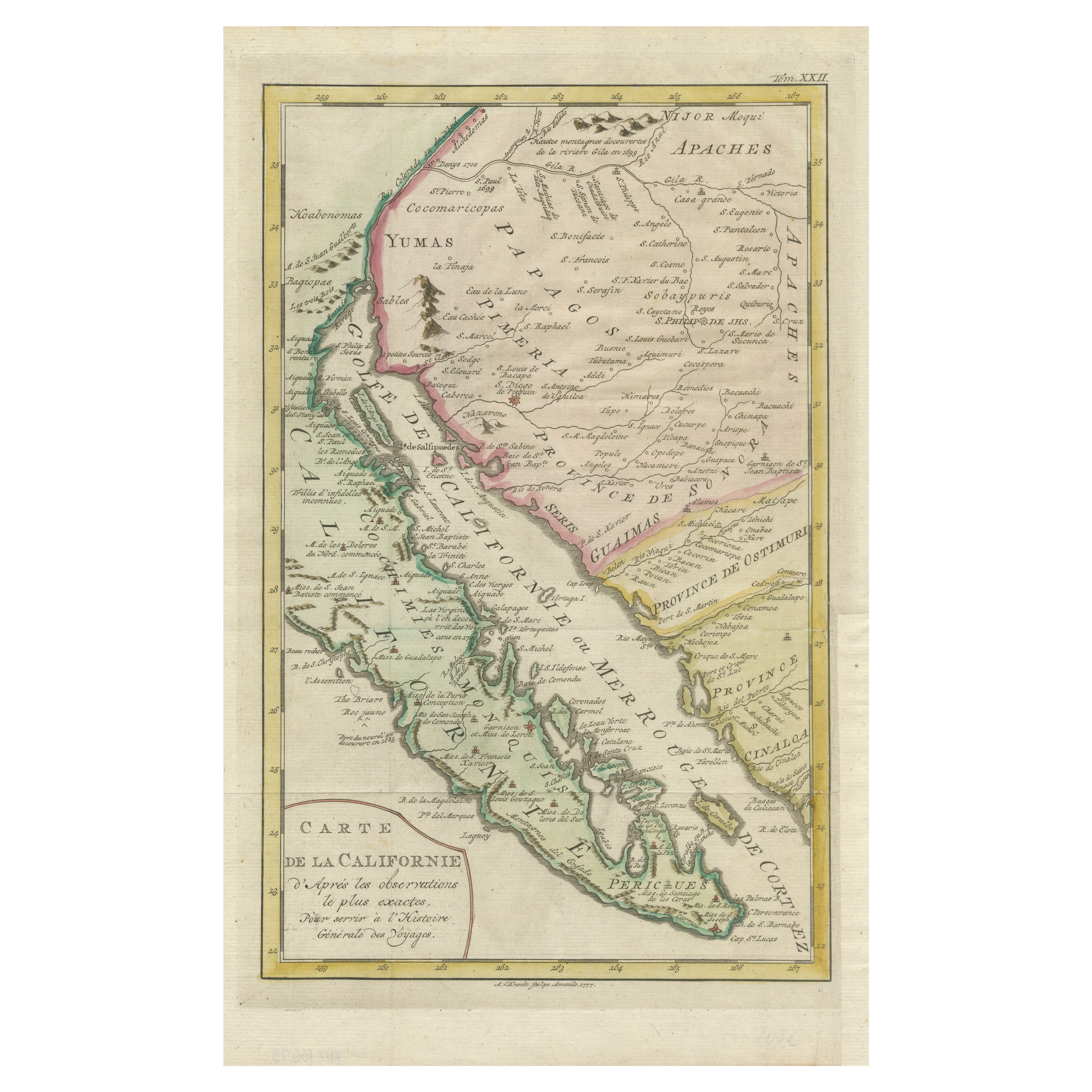
Title: Rare 1757 Jesuit Map of California and Baja, Dedicated to the King of Spain
This rare and detailed map, titled *Carte de la Californie Levee par la Société des Jésuites*, was produced in 1757 and dedicated to the King of Spain. It is a significant artifact from the Jesuit cartographic tradition, showcasing the geography of California, Baja California, and surrounding territories during the 18th century. The map highlights the missions established by the Jesuits, as well as key geographic features, including the Gulf of California (Sea of Cortez), the Colorado River, and the vast deserts inhabited by the Yumas, Apaches, and Papago tribes.
The map combines artistry and precision, reflecting the Jesuits’ commitment to scientific exploration and missionary work. It provides insights into the extensive network of missions and the relationships between European settlers and indigenous populations. Notable regions such as "Province de Ostimuri" and "Côte de Californie" are depicted, along with topographical details, rivers, mountain ranges, and coastal landmarks. The decorative cartouche adds a touch of elegance, underscoring its dedication to the Spanish monarchy.
The map holds historical value not only as a representation of the Jesuits’ efforts in the Americas but also as a testament to the evolving understanding of California's geography during this period. It is an exceptional piece for collectors interested in early cartography, Jesuit missions, or the history of California.
Condition:
This map is in very good condition for its age, with light toning and minimal foxing along the edges. The original hand coloring remains vibrant, enhancing the map's visual appeal. A slight centerfold is present, as issued.
Tips for Matting and Framing:
For an elegant display, use an archival cream or off-white mat that complements the warm tones of the map's hand coloring. Pair it with a gold or antique-style wooden frame to enhance its historical aesthetic. To preserve the map’s condition, use UV-protective glass and avoid displaying it in direct sunlight.
- Dimensions:Height: 14.77 in (37.5 cm)Width: 9.22 in (23.4 cm)Depth: 0.01 in (0.2 mm)
- Materials and Techniques:Paper,Engraved
- Period:1750-1759
- Date of Manufacture:1757
- Condition:This map is in very good condition for its age, with light toning and minimal foxing along the edges. The original hand coloring remains vibrant, enhancing the map's visual appeal. A slight centerfold is present, as issued.
- Seller Location:Langweer, NL
- Reference Number:Seller: BHZ100751stDibs: LU3054343469072
About the Seller
5.0
Recognized Seller
These prestigious sellers are industry leaders and represent the highest echelon for item quality and design.
Platinum Seller
Premium sellers with a 4.7+ rating and 24-hour response times
Established in 2009
1stDibs seller since 2017
2,511 sales on 1stDibs
Typical response time: <1 hour
- ShippingRetrieving quote...Shipping from: Langweer, Netherlands
- Return Policy
Authenticity Guarantee
In the unlikely event there’s an issue with an item’s authenticity, contact us within 1 year for a full refund. DetailsMoney-Back Guarantee
If your item is not as described, is damaged in transit, or does not arrive, contact us within 7 days for a full refund. Details24-Hour Cancellation
You have a 24-hour grace period in which to reconsider your purchase, with no questions asked.Vetted Professional Sellers
Our world-class sellers must adhere to strict standards for service and quality, maintaining the integrity of our listings.Price-Match Guarantee
If you find that a seller listed the same item for a lower price elsewhere, we’ll match it.Trusted Global Delivery
Our best-in-class carrier network provides specialized shipping options worldwide, including custom delivery.More From This Seller
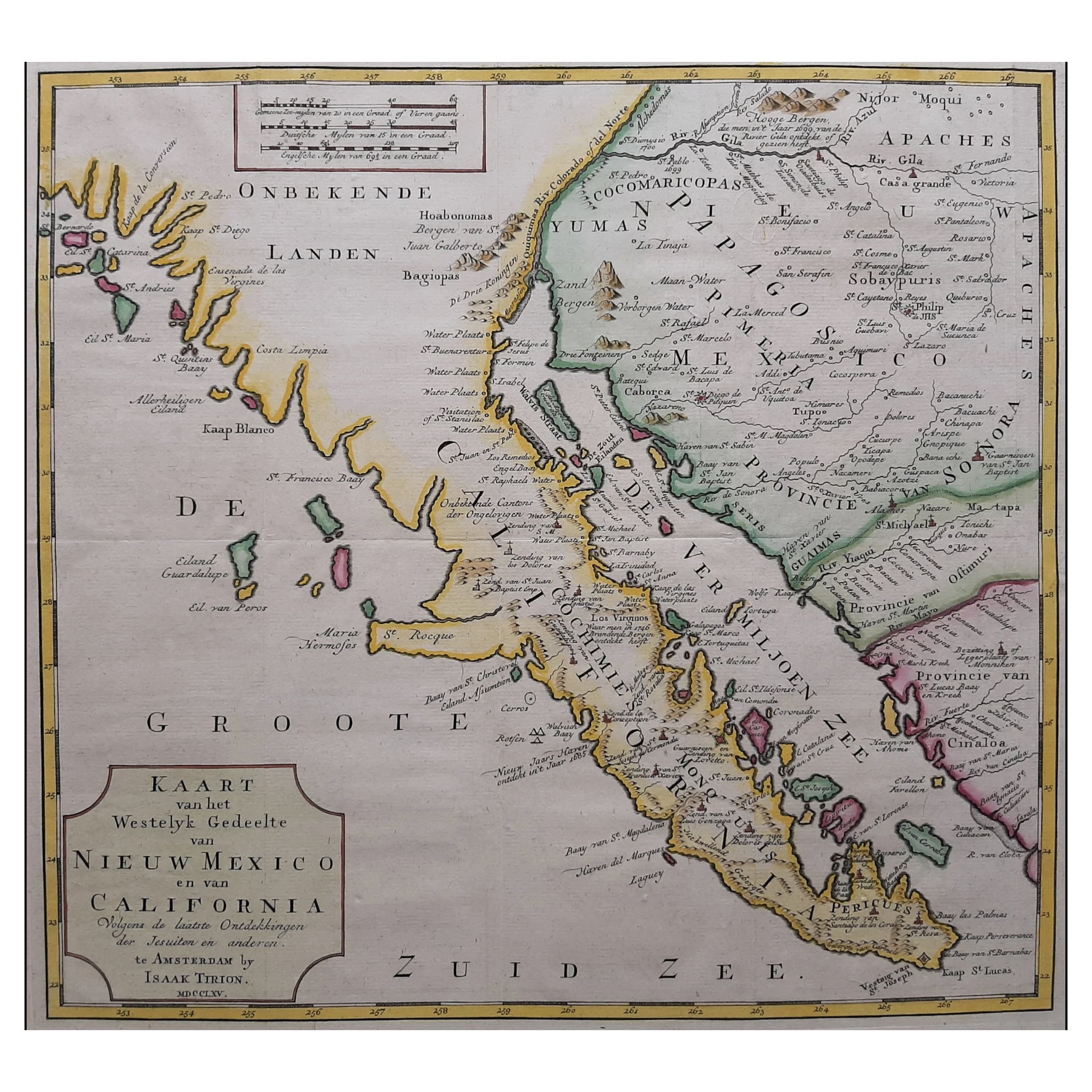
View AllMap of Baja California and Mexico - Jesuit Observations and Native Tribes, 1777
Located in Langweer, NL
1777 A. Krevelt Map of Baja California and Northwestern Mexico - Jesuit Observations and Native Tribes
A. Krevelt - Carte de la Californie d'Après les observations les plus exactes ...
Category
Antique 1770s Maps
Materials
Paper

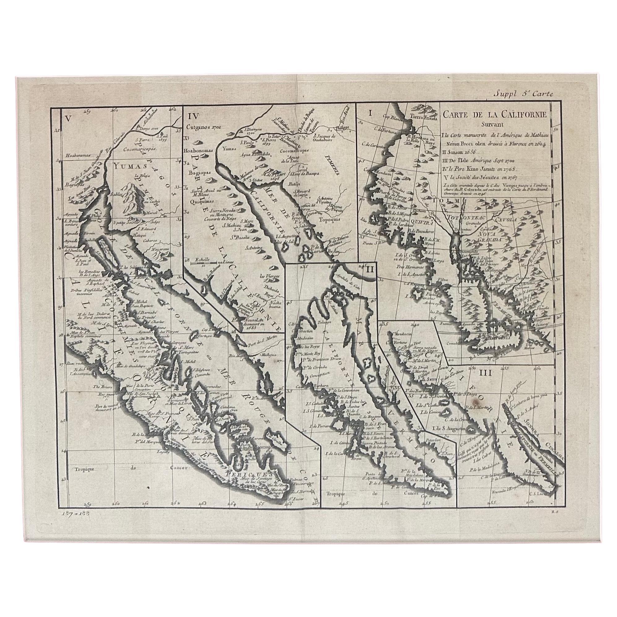
Original Antique Map of the Western Part of NEW MEXICO & CALIFORNIA
Located in Langweer, NL
Title: "Map of the Western Part of NEW MEXICO and CALIFORNIA According to the Latest Discoveries by the Jesuits and Others"
Description:
This exquisite original Dutch map, titled "...
Category
Antique 1760s Maps
Materials
Paper
$1,247 Sale Price
20% Off
Antique Map of America with California as an Island by Homann '1710'
Located in Langweer, NL
This antique map, titled "Totius Americae Septentrionalis et Meridionalis," represents a significant cartographic piece from 1710 by Johann Baptist Homann. Here's a description of this remarkable map:
- Title: Totius Americae Septentrionalis et Meridionalis (...)
- Date: Published in 1710 by Johann Baptist Homann.
Description:
This map is a first edition of Johann Baptiste Homann's map of America, and it is notable for several cartographic features and historical representations:
1. California as an Island...
Category
Antique Early 18th Century Maps
Materials
Paper

$2,248 Sale Price
25% Off
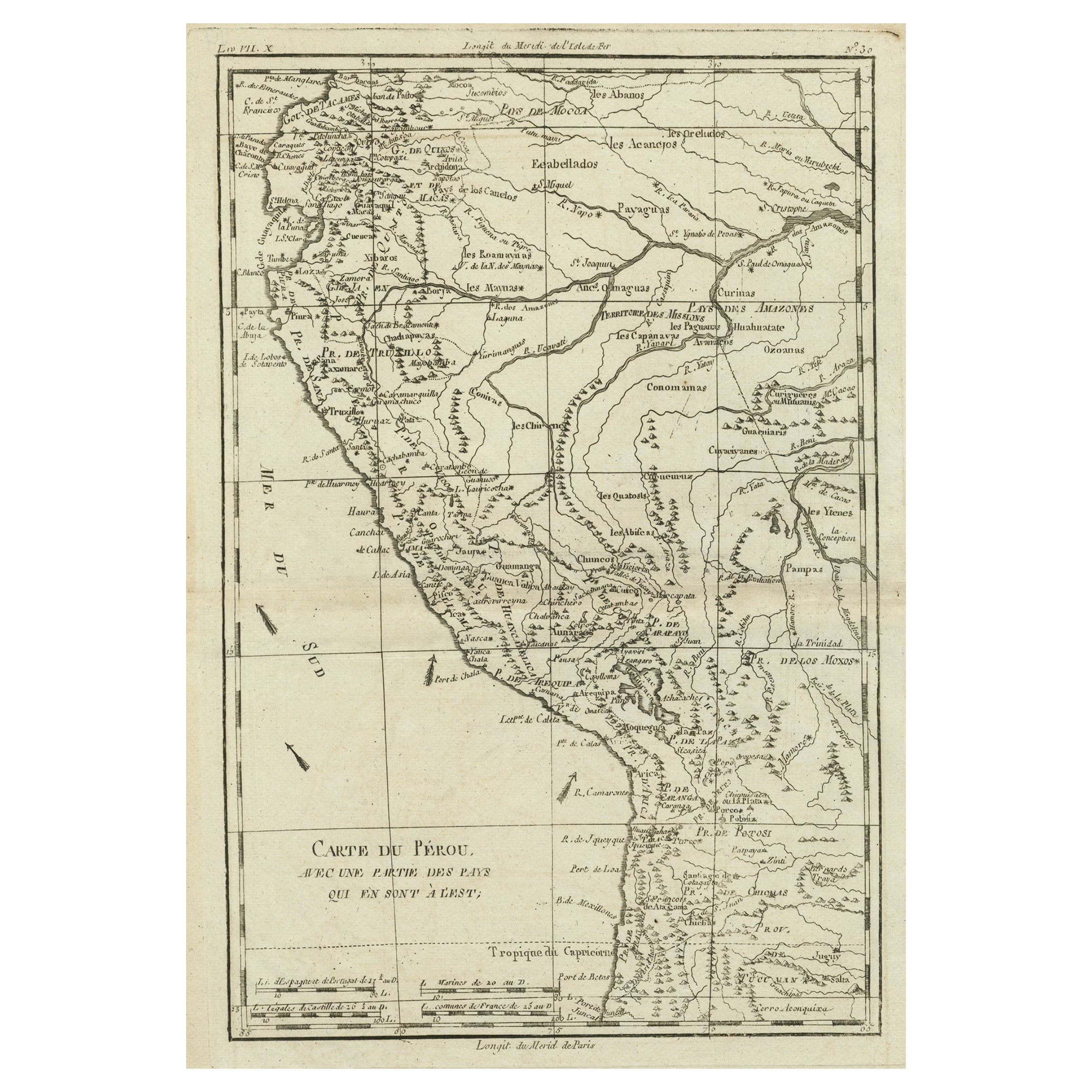
Map of the Western Coast of South America from Ecuador into Chili, ca.1780
Located in Langweer, NL
Antique map titled 'Carte du Perou avec une partie des pays qui en sont a l'est.'
Map of the western coast of South America extending from Ecuador, through Peru and present-day B...
Category
Antique 1780s Maps
Materials
Paper
$326 Sale Price
20% Off
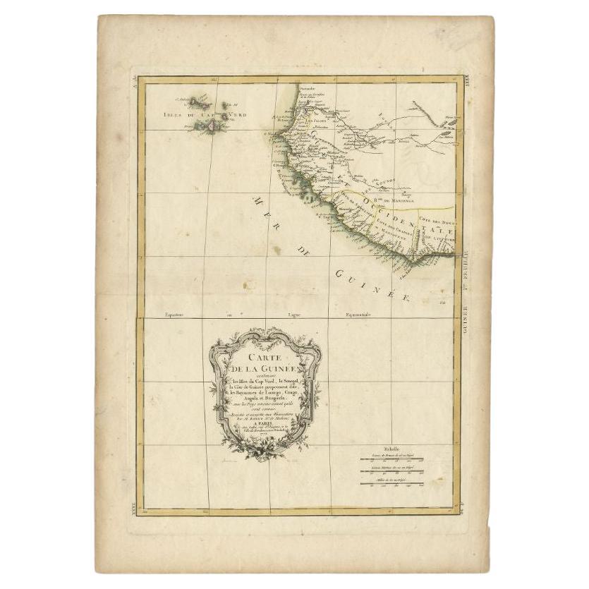
Antique Map of the West Coast of Africa, 1771
By Rigobert Bonne
Located in Langweer, NL
Antique map titled 'Carte de la Guinee contenant les Isles du Cap Verd, le Senegal, la Cote de Guinee proprement dite, les Royaumes de Loango, Congo, Angola, et Benguela avec les Pay...
Category
Antique 18th Century Maps
Materials
Paper

$335 Sale Price
20% Off
Rare Antique Map of Southwestern Europe and West Africa by V.M. Coronelli, 1692
By Vincenzo Coronelli
Located in Langweer, NL
Antique Globe Gore: Southwestern Europe and West Africa by Vincenzo Coronelli
This exquisite, hand-colored globe gore by Vincenzo Coronelli, one of the most renowned 17th-century cartographers, represents Southwestern Europe and West Africa. A segment of Coronelli's monumental 42-inch terrestrial globe, this gore is a remarkable example of the artistry and geographical knowledge of the late 1600s. Covering France, the Iberian Peninsula, and all of Africa west of a line extending from Algeria to the Bight of Benin, it also includes the Canary Islands and Madeira.
Coronelli’s globe gores are celebrated for their exceptional engraving and accuracy, and this piece is no exception. The coastline of Africa is depicted with remarkable precision for its time, reflecting the latest geographical knowledge of European explorers. In contrast, the interior of Africa—still a mystery to European mapmakers—features mythical elements such as fantastical mountain ranges and exotic fauna. Giraffes, elephants, lions, and mysterious giant birds populate the landscape, offering a glimpse into the imagination and curiosity of the era. One notable detail is the Gambia...
Category
Antique Late 17th Century Maps
Materials
Paper
$2,350 Sale Price
20% Off
You May Also Like
Antique Map of California as an Island "The 5 Californias" by Robert de Vaugondy
Located in San Diego, CA
A very nice and rare antique map entitled "Carte de la Californie Suivant" (The 5 Californias), by Didier Robert de Vaugondy of Paris, circa 1772. The map itself measures 15.5" x 13...
Category
Antique Mid-19th Century American Maps
Materials
Paper

California, Alaska and Mexico: 18th Century Hand-Colored Map by de Vaugondy
By Didier Robert de Vaugondy
Located in Alamo, CA
This is an 18th century hand-colored map of the western portions of North America entitled "Carte de la Californie et des Pays Nord-Ouest separés de l'Asie par le détroit d'Anian, ex...
Category
Antique 1770s French Maps
Materials
Paper

1847 Antique Map of Mexico, Texas and California by Samuel Augustus Mitchell
By Samuel Augustus Mitchell 1
Located in Colorado Springs, CO
Presented is the second edition of Samuel Augustus Mitchell's Map of Mexico, Including Yucatan & Upper California, an important map showing the progress of the Mexican-American War. ...
Category
Antique 1840s American Maps
Materials
Paper

West Coast of Africa, Guinea & Sierra Leone: An 18th Century Map by Bellin
By Jacques-Nicolas Bellin
Located in Alamo, CA
Jacques Bellin's copper-plate map entitled "Partie de la Coste de Guinee Dupuis la Riviere de Sierra Leona Jusquau Cap das Palmas", depicting the coast of Guinea and Sierra Leone in ...
Category
Antique Mid-18th Century French Maps
Materials
Paper

California: 18th Century Hand-colored Map by de Vaugondy
By Didier Robert de Vaugondy
Located in Alamo, CA
This is an 18th century hand-colored map of the western portions of North America entitled "Carte de la Californie et des Pays Nord-Ouest separés de l'Asie par le détroit d'Anian, ex...
Category
1770s Landscape Prints
Materials
Engraving

"Nova Barbariae Descriptio", a 17th Century Hand-Colored Map of North Africa
By Johannes Janssonius
Located in Alamo, CA
This original attractive 17th century hand-colored map of North Africa entitled "Nova Barbariae Descriptio" by Johannes Janssonius was published in Paris in 1635. It includes the Med...
Category
Antique Mid-17th Century Dutch Maps
Materials
Paper

More Ways To Browse
Spanish Mission Furniture
Antique Furniture California
Spanish Mission Style
California Mission Furniture
Carlo Scarpa 1934 Chairs
Christofle Marly
1900 Antique Chairs
Glass Table Italian Round
Alvar Aalto Poster
Geometric Metal Table
Post Modern High Chairs
Vintage Vine Rug
Cancel An Order
Antique Framing Square
Silver Metal Chair
Swedish Kilim
Vintage Scandanavian Chairs
Vintage Tropical Furniture